
Stations
Go directly to a station using the buttons below, or at the top of the screen to move through the stations in order. You can review and provide feedback on any or all of the areas that interest you. You do not have to visit every page or answer every question.
Please provide your comments by Monday, June 7th.
Click or tap “Get Started” above or use the links below to skip to specific information.

= Page includes questions or opportunities for comment.
Image gallery contents:
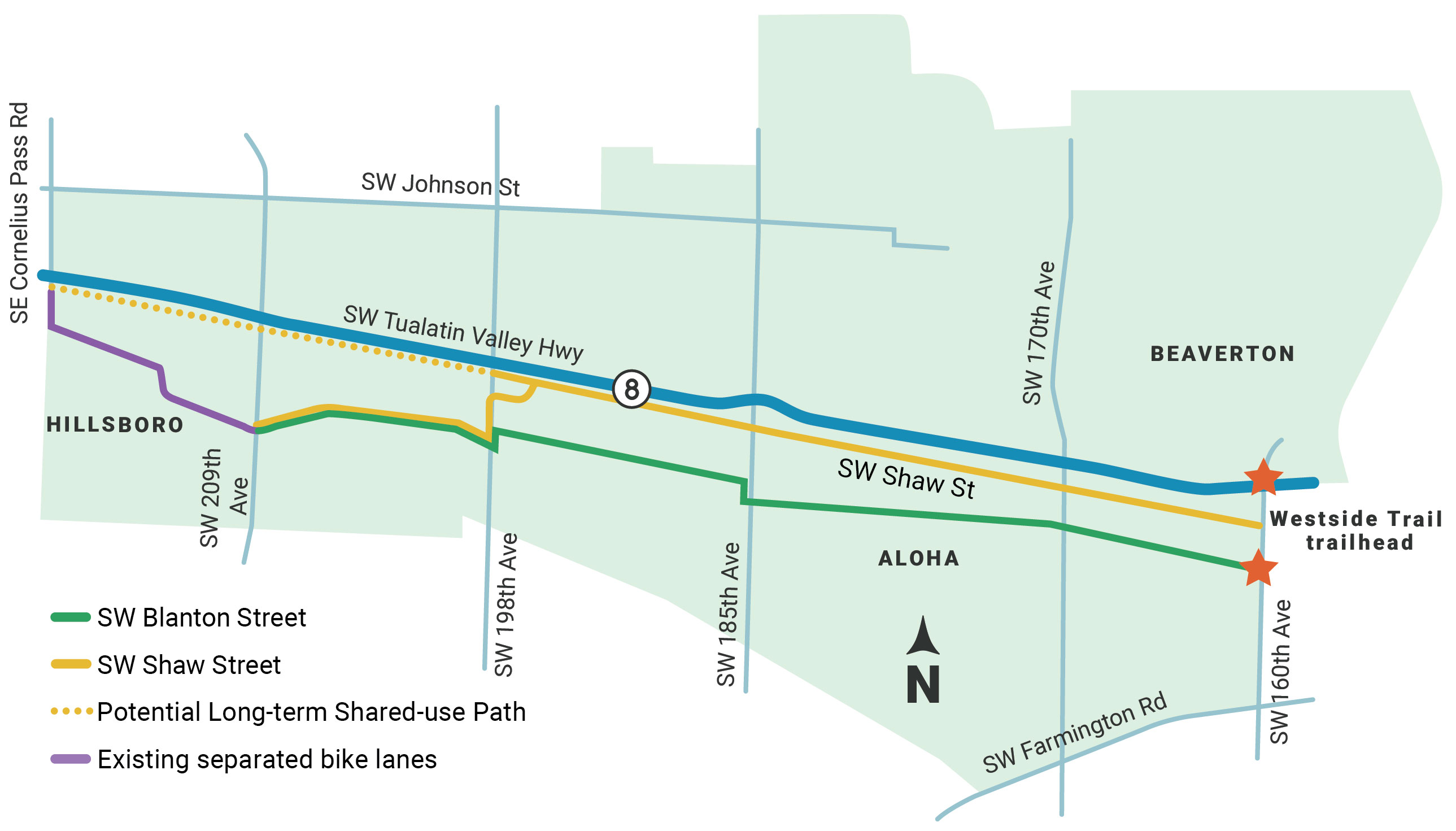
TV Trail Corridor Map
TV Trail Corridor Map


What has been done so far
We’ve heard a clear preference for better walking, rolling and biking conditions south of TV Highway. Based on that feedback we narrowed down five potential routes down to two: SW Blanton and SW Shaw. The County has spent the last few months developing and evaluating potential design concepts for both streets. Now, we need your input about both corridors as we finalize the TV Trail Concept Plan.
Conceptual design is an early phase of the design process in which the broad outlines of function and form are defined.
A new trail would offer…
An alternative to TV Highway that feels comfortable for all ages and abilities to walk, roll and bike – whether for fun and fitness or getting to work or school, running errands, or catching a bus or MAX train.
A connection to other regional trails.
Goals, Objectives and Evaluation Criteria
The project goals, objectives, and evaluation criteria were developed with direction from policymakers, the project management team, and community input.
Image gallery contents:
Blanton Corridor
Blanton Typical Cross-Section
Cross-section intended for illustrative purposes only
Blanton 3D Visualization
Visualization intended for illustrative purposes only
Blanton Cross-Section with Parking on One Side
Cross-section intended for illustrative purposes only
Blanton 3D Visualization with Parking on One Side
Visualization intended for illustrative purposes only
Blanton Narrow Cross-Section
Cross-section intended for illustrative purposes only
Half-signal
Walker at Waterhouse Trail


Background
The majority of SW Blanton Street between 160th Ave and 209th Ave lacks sidewalks and bike lanes. We have heard Blanton Street is a priority for better walking, rolling, and biking conditions. The TV Trail Concept Plan is exploring design concepts for SW Blanton that is accessible and comfortable for all ages and abilities.
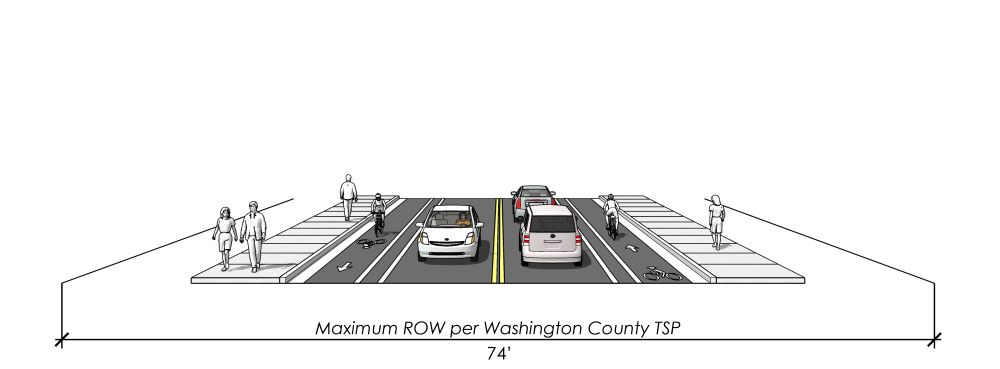
Washington County’s Transportation System Plan designates SW Blanton Street as a Collector Street. Collector Streets provide both access and circulation between residential, commercial, and industrial areas and provide access to larger streets. Collector Streets require up to 74-foot of right-of-way.
Design and traffic considerations:
- Design as a “complete street” - narrower travel lanes, separated bike lanes, landscape buffer, sidewalks, and parking where feasible.
Tradeoffs between private property impacts, level of comfort for people walking, rolling and biking, and how to accommodate on-street parking.
Signalized trail crossings at major streets like SW 198th Avenue, SW 185th Avenue, and SW 160th Avenue.
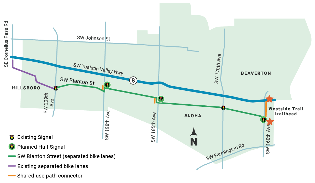
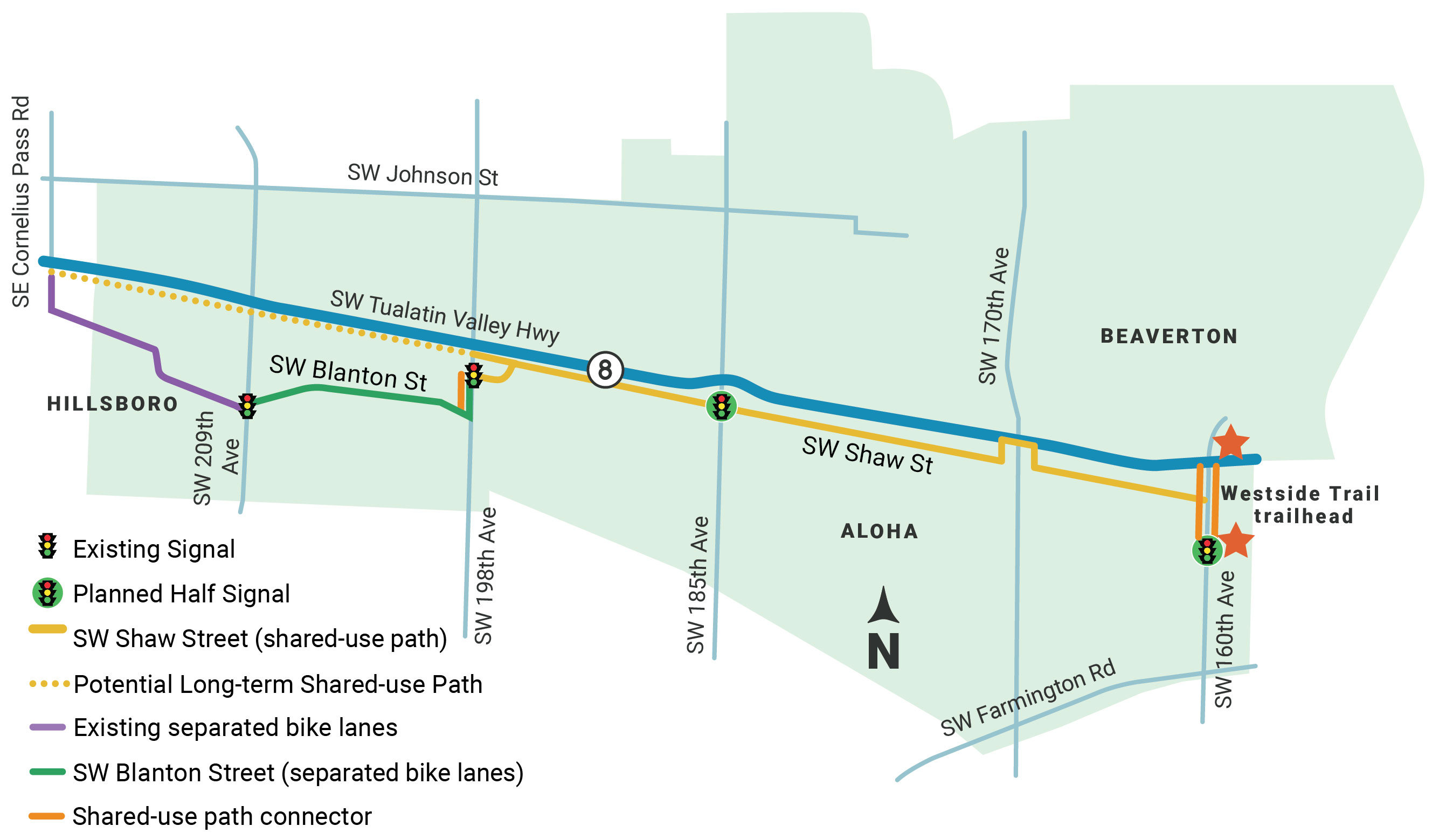
Blanton Corridor Map

Click on the image to enlarge.
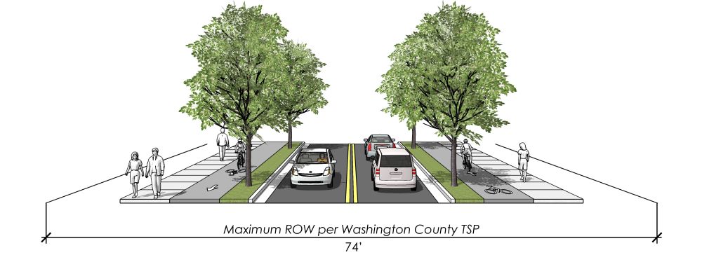
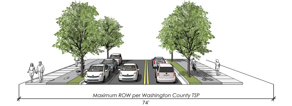
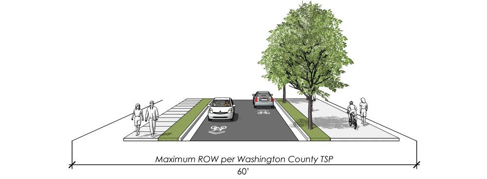
Typical Cross-Section

Click on the image to enlarge.
Cross-section intended for illustrative purposes only.
The typical cross-section is approximately 60-feet wide and physically separates bike lanes and sidewalks from the roadway with landscape buffers and raised curbs providing the highest level of comfort for all ages and abilities. This cross-section requires relatively minimal property impacts.
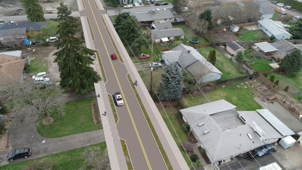
Blanton 3-D Visualization

Click on the image to enlarge.
Visualization intended for illustrative purposes only.
Wider Cross-section (Parking on One Side)
Click on the image to enlarge.
Cross-section intended for illustrative purposes only.
A wider cross-section could be considered on segments of the corridor creating space for on-street parking and turn-lanes, where applicable. However, this would require additional property and result in a more expensive project.
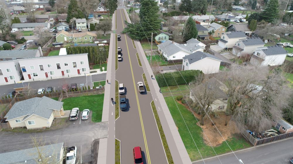
3D Visualization Cross-Section with Parking on One Side

Click on the image to enlarge.
Visualization intended for illustrative purposes only.
Narrower Cross-Section
Click on the image to enlarge.
Cross-section intended for illustrative purposes only.
The narrower cross-section separates the bike lane from traffic with a painted buffer only which may not be comfortable for all ages and abilities compared to the fully separated bike lane shown in the typical cross-section. However, this cross-section requires the least amount of additional property.
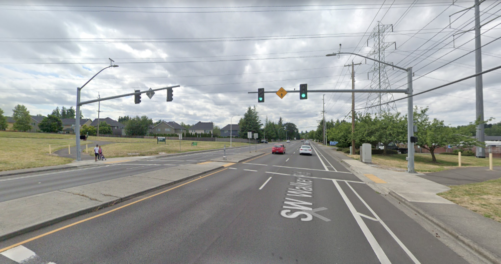
Signalized Crossings

Click on the image to enlarge.
Example of a half-signal at SW Walker Rd and Waterhouse Trail
Half-signals are recommended at the major unsignalized intersections along SW Blanton Street at SW 198th Ave, SW 185th Ave, and SW 160th Ave to help people walking, biking, and rolling to cross the street.
At a half-signal, cars have a green light until a person walking, biking, or rolling presses a button to cross. Then cars get a red light and people crossing get a walk sign.
Questions
Image gallery contents:
Shaw Corridor
Shaw Corridor
Typical Cross-Section
Shaw Corridor
3D Visualization Graphic
Shaw Crossing at 185th
Shaw Crossing at 170th
Shaw Crossing at 160th


Overview
The majority of SW Shaw Street between 160th Ave and 198th Ave lacks sidewalks. We have heard Shaw Street lacks the type of environment that people would like to travel within and doesn’t have as many community destinations as SW Blanton. However, SW Shaw does offer fewer conflict points between cars and people biking, walking and rolling since there are no driveways along the northside of the street between 160th Ave and 198th Ave.
The TV Trail route would likely need to use Blanton west of 198th Ave in the near-term to connect to existing separated bike lanes and sidewalks at 209th Ave. However, in the longer-term the TV Trail could connect more directly to a future segment of the TV Trail west of 209th Ave.
Design and traffic considerations:
- Designed with a shared-use path between the street and the railroad tracks.
Direct and signalized crossings of the major streets may be needed for the trail to be comfortable and convenient for users.
Map of Shaw Corridor

Click image to enlarge.
Typical Cross-Section

Click image to enlarge.
Cross-section intended for illustrative purposes only.
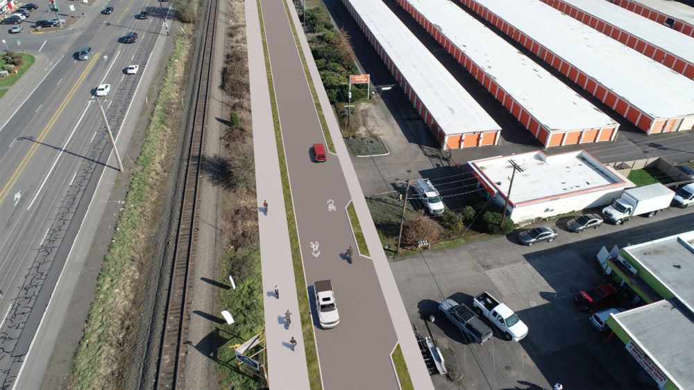
The typical cross-section includes a shared-use path physically separated from the roadway with a landscape buffer and raised curbs.
3D Visualization of Shaw

Click image to enlarge.
Visualization intended for illustrative purposes only.
Future design considerations for Shaw Street:
- Where on-street parking may be needed
- Designated railroad crossing opportunities
- Need for a barrier between the railroad and the trail
Signalized Crossings
Similar to Blanton Street, crossings are an essential element in providing an accessible, comfortable, and low-stress experience for people walking, biking, and rolling across major intersections.
We are exploring the feasibility of pedestrian half-signals at the major streets such as SW 185th Avenue, SW 170th Avenue, and SW 160th Avenue. However, building these will be challenging due to the proximity to the railroad and TV Highway. If not feasible, people would need to cross the railroad tracks and use the existing crosswalks at TV Highway.
Crossing at SW 185th St
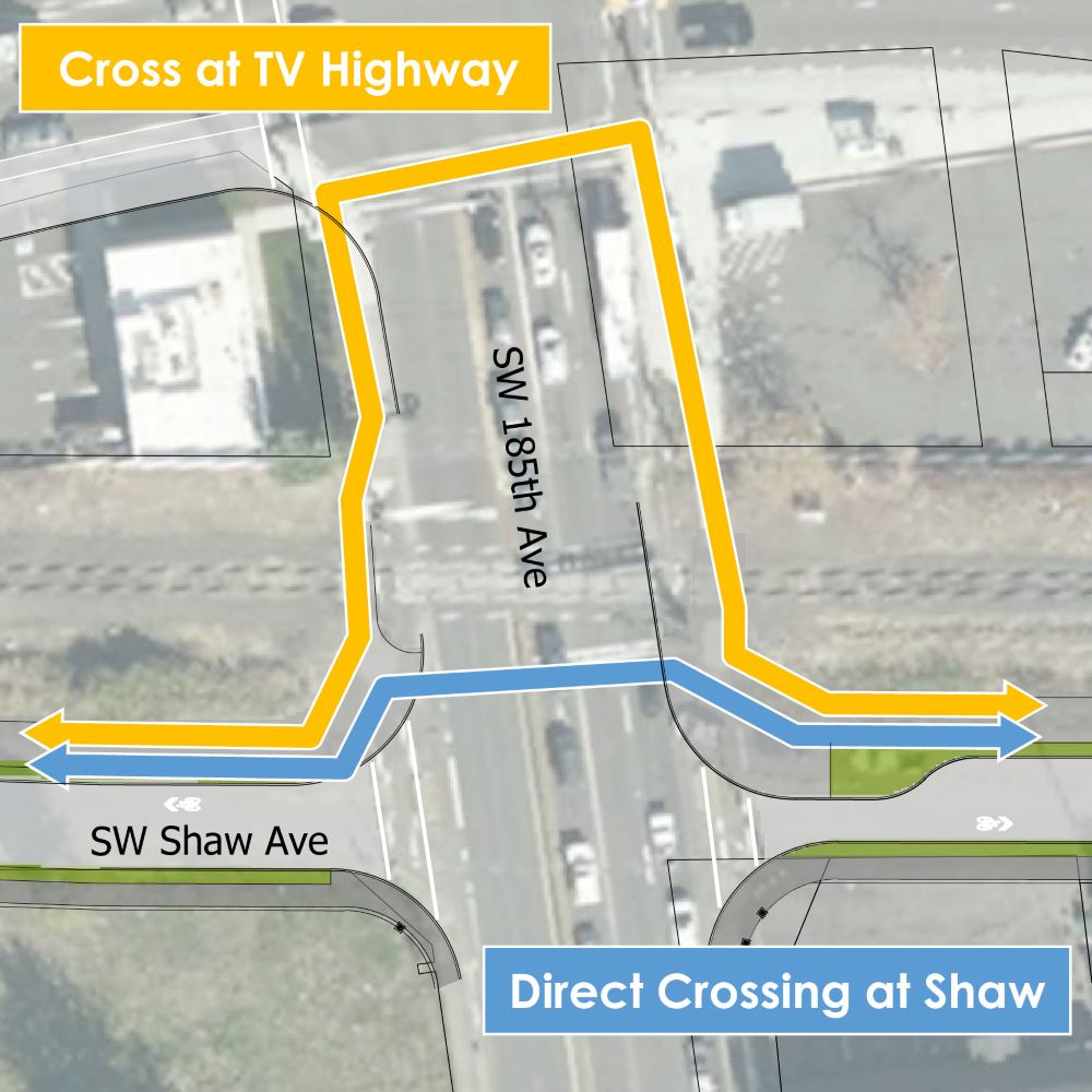
Click image to enlarge.
Crossing at SW 170th St
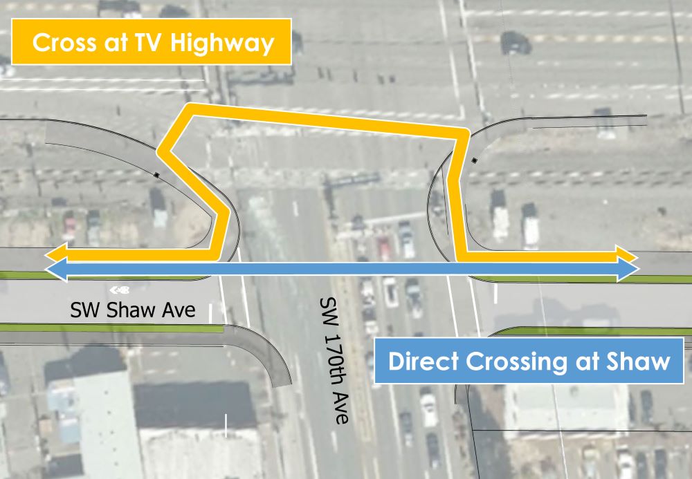
Click image to enlarge.
Crossing at SW 160th St
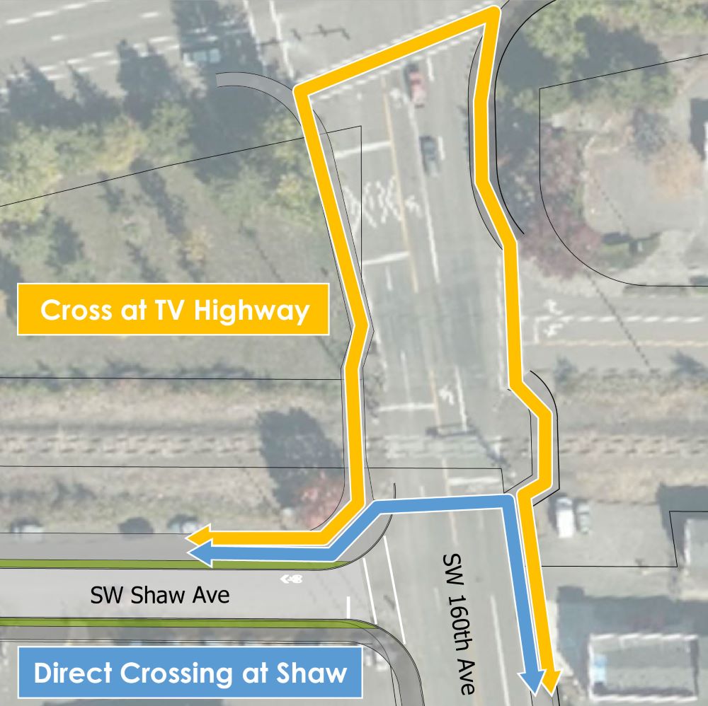
Click image to enlarge.
Questions
Image gallery contents:
Route Tradeoffs
Route Tradeoffs


Timeline
Both corridors are likely to be included in the TV Trail Concept Plan which will document the design concept for each corridor and the key issues that need further evaluation. It is anticipated that the TV Trail Concept Plan will inform applicable Washington County Comprehensive Plan elements including the Transportation System Plan and Aloha-Reedville Community Plan. The Board of County Commissioners will be briefed on the TV Trail Concept Plan recommendations and community input during a June 1, 2021 work session and will direct staff on next steps.
The following table describes some of the tradeoffs between the two TV Trail route options.
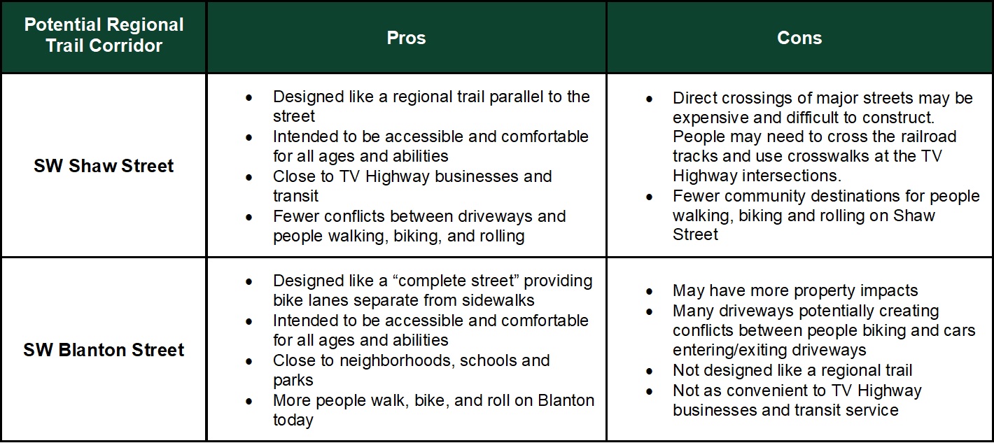
Click table to enlarge. You can also view a PDF version here.
Final Questions
Email Sign-up
Demographics Questions (Optional)
We're asking these questions to help us evaluate the effectiveness of our outreach activities. Answering these questions is completely optional.
The option to review and submit answers will appear after you answer at least one question.
