View the information on this site using the buttons below or click "Get Started" above to move through the content in order.

= Page includes questions or opportunities for comment.
Josephine County is also considering a major update to their TSP for that part of the county outside of Grants Pass. You can visit the County TSP website and public open house meeting here:


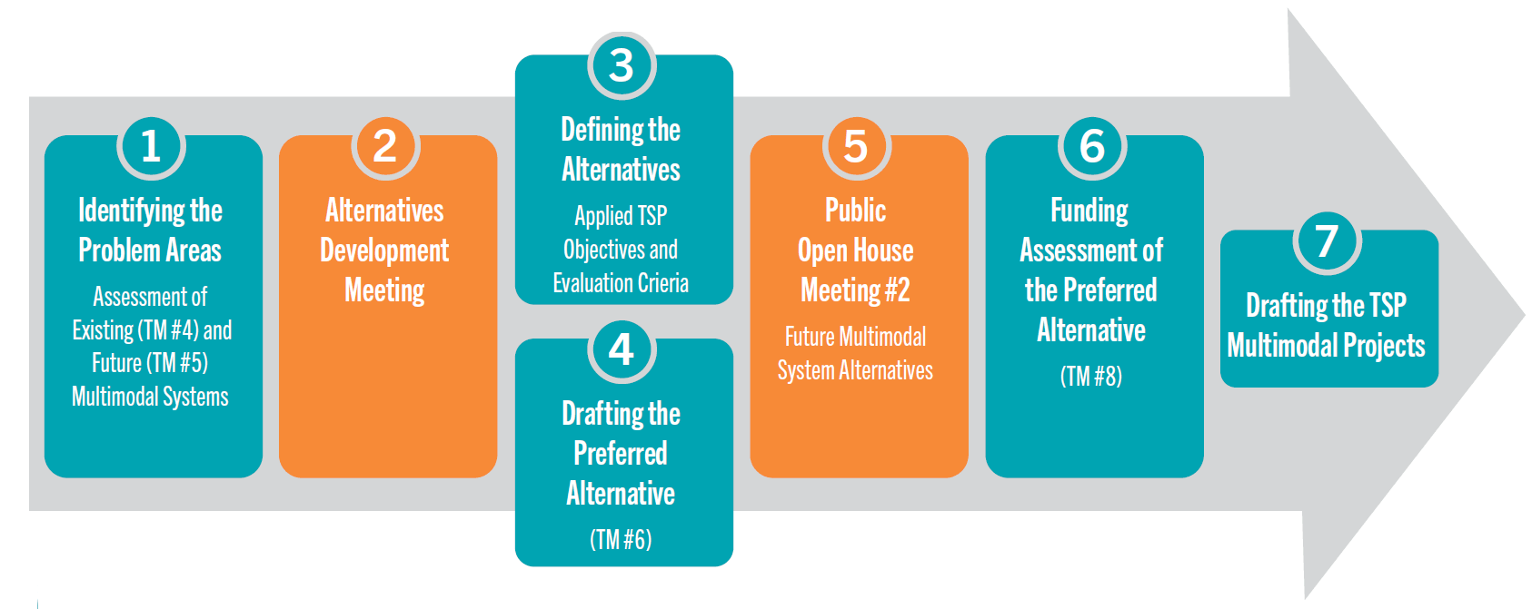
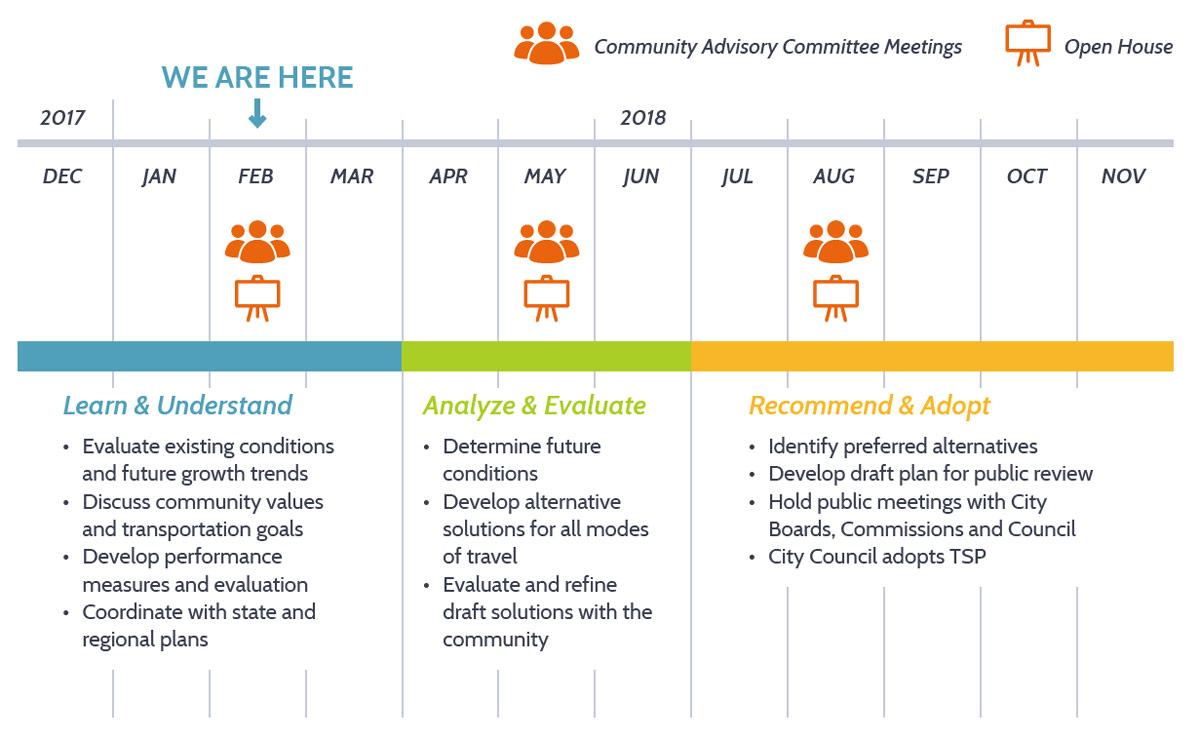
Process overview
The 2040 Grants Pass TSP process followed a series of analytical steps with technical committee advisory guidance and citizen input to help identify key transportation system problem areas and potential solutions to resolve them.
(Click to enlarge.)
...READ MORE: Steps to Drafting the TSP
What we heard
At our last online open house, we identified a set of problem areas and asked for feedback. Most respondents agreed with the set of identified problems and many provided additional suggestions, specific project ideas and general comments. Commenters emphasized the importance of:
- Addressing increasing traffic and congestion.
- Addressing cut-through traffic in neighborhoods.
- Providing safer pedestrian crossings.
- Providing better sidewalks and walking connections.
Project goals
The TSP Update has been informed by a set of Goals. These goals provided the project team with direction throughout the project and guide the City after plans are adopted. The project team used public feedback to refine these draft Goals and to develop performance measures to evaluate the proposed improvements and projects.
- Provide for the safe and efficient accommodation of travel through a variety of transportation modes, including private vehicles, public transportation, bicycles, and walking.
- A well-coordinated plan between the City of Grants Pass, Josephine County and the Oregon Department of Transportation.
- Provide continued funding to invest in the maintenance and operations of the Grants Pass transportation network.
- Provide a transportation network with acceptable levels of traffic congestion, accessibility to jobs and adequate movement of goods to support economic development.
- A transportation plan that helps preserve and enhance the city's physical surroundings and maintains a high quality of life.
- A plan that ensures stable financing sources to fund new transportation improvements and conduct ongoing maintenance and operations.
- A plan with effective strategies to systematically implement the city’s planned transportation improvements.
- Provide a transportation system that enhances the health and safety of Grants Pass' residents.
Read the full list of Goals (pdf, 513 KB.)
On the following pages, we will want to know if the proposed projects successfully achieve the project goals and address public concerns.
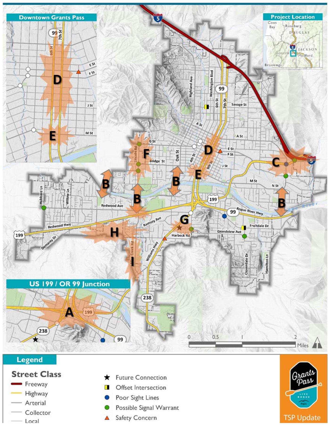
Problem Areas

(Click to enlarge.) The decisions we make today will directly impact how the city can grow in the future. There are currently 143 miles of city streets in the Grants Pass transportation system, as well as over 190 miles of sidewalks and trails. All of this infrastructure requires money to maintain, so we have to choose new investments carefully.


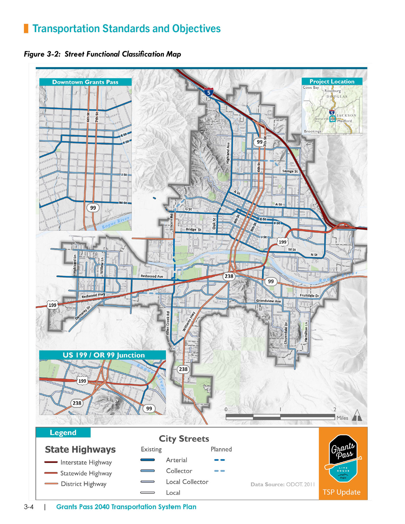
Street Functional Classification
Streets and highways within the Grants Pass urban network are grouped, or classified, with other streets that share similar characteristics of purpose, design, and function.
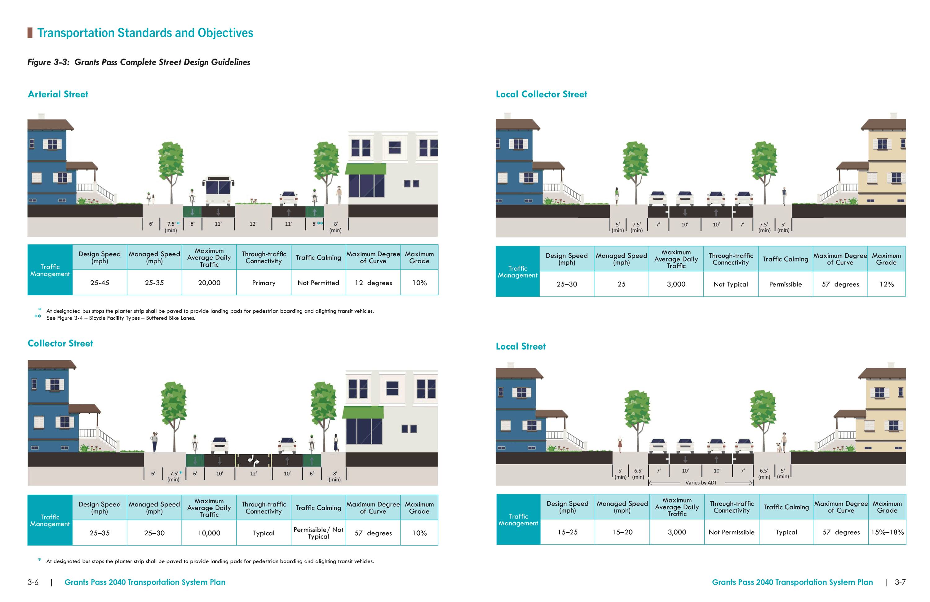
Complete Street Design Guide
Consistent application of the city’s street design standards help ensure that each street improvement is consistent with the look and feel of the surrounding land use, and meets the expectations of motorists, pedestrians, and cyclists. The TSP has identified minor refinements to the Grants Pass street design standards and Development Code to better implement the city’s policies of multimodal streets.
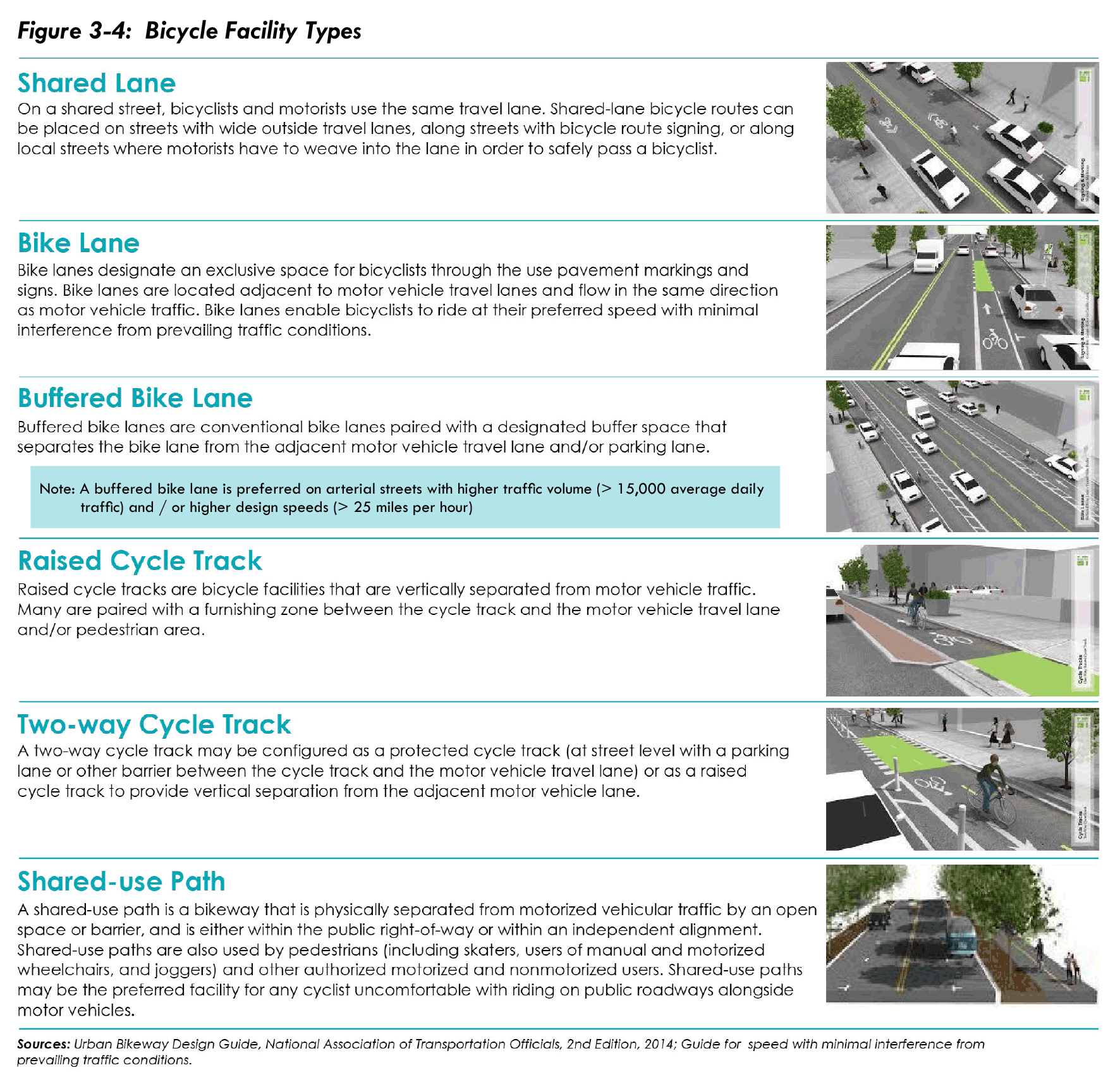
Bicycle Facility Types
The City can continue proactively planning for bicycle facilities by expanding upon and clarifying the definitions of the various bicycle facilities, especially for the on-street bicycle system. The TSP Update introduces a wider array of bicycle facility design options that better match the cycling needs of Grants Pass residents. Implementation of the TSP bicycle facility types help make a more connected and accessible network of bicycle routes that serve riders with vary skill and confidence levels.
...READ MORE: Transportation Standards and Guidelines
Questions

Sources
The 2040 TSP has identified and estimated three key measures to determine the City's capacity to fund projects:
- Grants Pass' future transportation revenues (2040 planning horizon), by revenue source (see table)
- The City's future transportation operations and maintenance program needs (Program Expenses)
- The City's future transportation revenue capacity available for multi-modal capital improvement projects
Subtracting the city's operation and maintenance program needs ($42 million) from total transportation revenues ($113.7 million) leaves approximately $71.7 million available for capital improvements.
...READ MORE: Funding Assessment
Prioritizing Projects
Grants Pass’ multimodal project priorities were drafted based on future traffic conditions, gaps in the city-wide network, community feedback and estimated available funding.
To categorize the TSP priorities, the multimodal project list has been divided into three tiers:
- Tier 1 projects are of the highest priority and most likely to be funded by year 2040. Tier 1 is the ‘constrained’ project list based on 100% of the city’s estimated funding capacity for capital improvements through year 2040 (a relatively conservative estimate).
- Tier 2 projects are high priority, but it is uncertain that there will be sufficient funding to complete all Tier 2 projects by 2040, unless there is more transportation revenue available than conservatively estimated. Tier 2 is based on 150% of the city’s funding capacity.
- Tier 3 contains projects that are likely to be completed after year 2040 or when unforeseen funding becomes available. Tier 3 also contains projects that are funded by private development.
Tier 1 and Tier 2 projects were also selected based on two complimentary objectives: 1) they should be multimodal projects that are evenly spread throughout the Grants Pass urban area and 2) they should help complete critical pedestrian and bicycle network connections that support future transit systems development and offer Grants Pass residents and visitors the greatest mobility choice. State highway improvement projects are noted in the Grants Pass TSP and prioritized only by general need in each Tier, but not by the State’s funding capacity.
On the next pages, you can give us feedback on how the proposed projects are prioritized by tier.
Funding for Capital Improvements - 20-Year Estimate
| Transportation Revenue | through 2040 | |
CMAQ | $7,700,000 | |
Total Revenue | $113,725,000 | |
| less | Program Expenses | through 2040 |
| Operations Maintenance | $16,099,000 $25,906,000 | |
Total Expenses | $42,005,000 | |
| net | Available for Capital Improvements | through 2040 |
Tier 1 Projects | $71,720,000 |
All figures in 2019 dollars. Source: City of Grants Pass.
Street Projects


Proposed Projects
Tier 1
- New Fourth Bridge rights-of-way and approach improvements (cost of new bridge prioritized in Tier 3),
- West Park Street extension (to the new Fourth Bridge corridor, north of Josephine County Fairgrounds),
- Redwood Avenue re-alignment,
- Dimmick Street Extension between G Street and F Street (including new railroad crossing),
- Upgrades to urban street standards on Highland Avenue, Fruitdale Road, East Park , Harbeck Road, Hillcrest Drive, 10th Street and Savage Street, and
- New smart parking, intelligent transportation system (ITS) signing and infrastructure in downtown Grants Pass.
High priority, Tier 1 improvements also include the I-5 Exit 55 Interchange enhancements, with new traffic signal or roundabout at the intersection of US 199 and Southbound I-5 off-ramp, and intersection enhancements at US 199/Agness Avenue to better accommodate truck movements.
Tier 2
- New street extensions including Shutzwohl Lane, Leonard Road (to Kellenbeck Avenue), and Dimmick Street,
- Urban street upgrades on Beacon Drive, Dowell Road, Fruitdale Drive, Cloverlawn Drive, and
- New traffic signals on Bridge Street at 4th and 5th Streets.
Tier 3
The City will likely pursue state and federal funding support for the construction of the new Fourth Bridge, as prioritized in Tier 3.
Urban street upgrade projects are identified on several city streets, including Hamilton Lane, Dowell Road, Fruitdale Drive, Haviland Drive, Cloverlawn Drive, Shannon Lane, Scenic Drive, Scoville Road, Estates Lane, Vine Street and Wolf Lane. New traffic signals may be warranted at the interstions of A Street and Beacon Drive, and at N Street and Agness Road.
Several new street improvement projects identified in Tier 3 are located in areas of planned development, thus it is likely that private development will contribute to their funding or fund them entirely. Tier 3 street projects include portions of Service Road, Crown Street, Coach Drive, Raydean Drive and George Tweed Boulevard.
Future improvements to the state highway system are also prioritized in Tier 3, including (1) widening OR 238 from New Hope Road to the UGB (two travel lanes, bike lanes and new sidewalks), and (2) widening US 199 to six travel lanes from Tussey Lane to Dowell Road ( a state-funded project). These projects are dependent on state funding sources and ODOT priorities, and may occur within the 20-year planning horizon
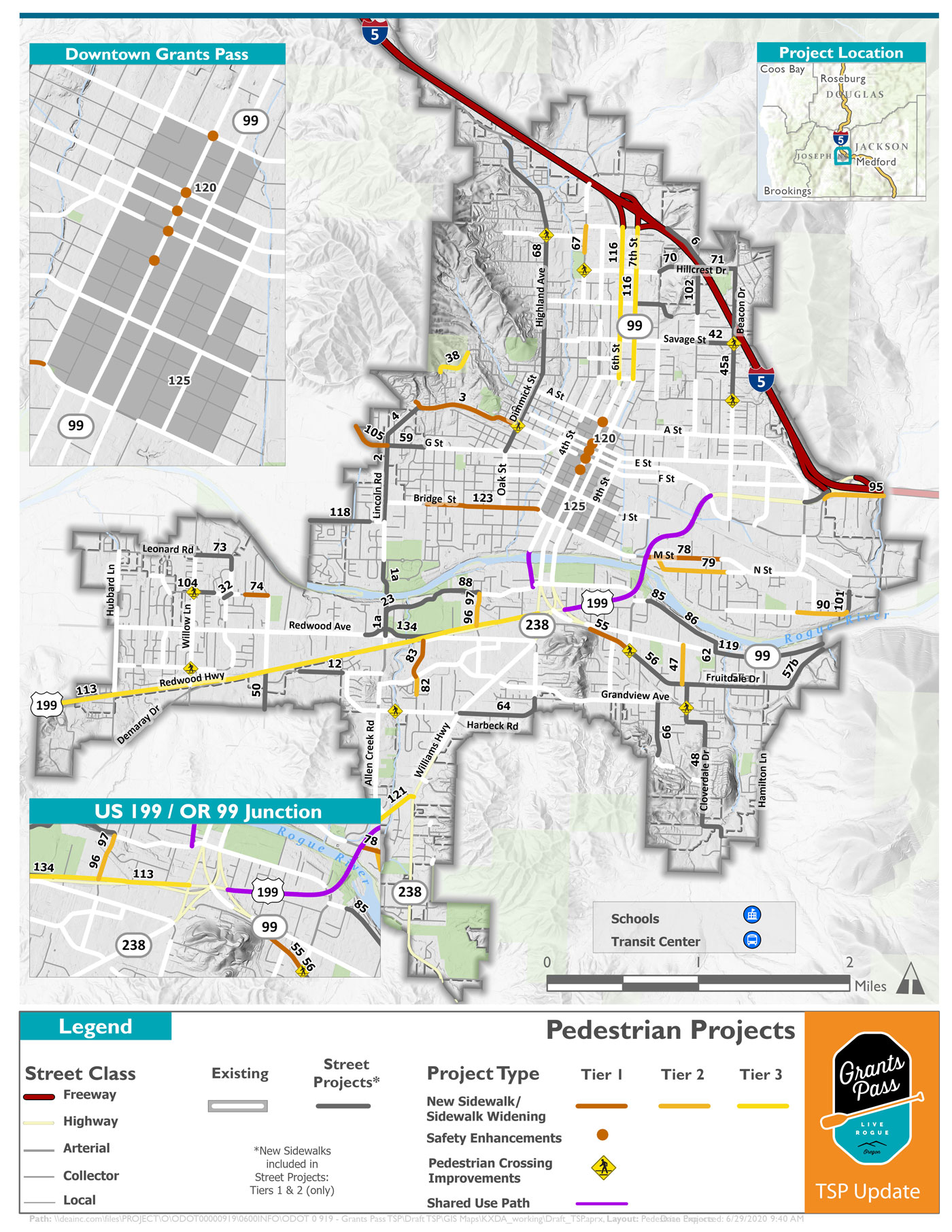
Street Project Locations
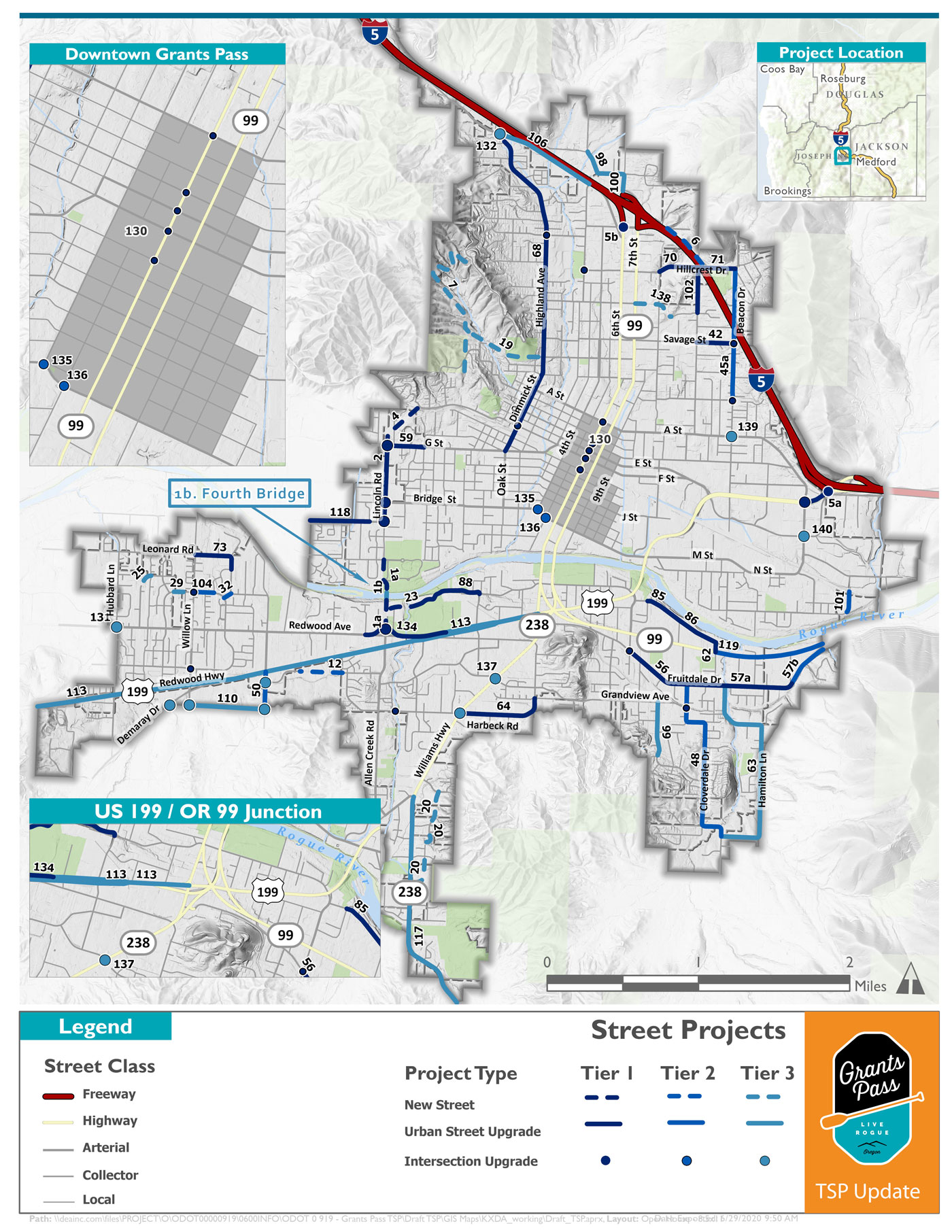
Click to enlarge image.
Questions
grants-pass-tsp/ooh3/map-pedestrian-projects


Proposed Projects
Tier 1
- New sidewalks to complete the pedestrian network along key street corridors (F Street, Fruitdale Drive, M Street, Nebraska Avenue, Upper River Road, Bridge Street and Hawthorne Lane),
- New 5th Street Rogue River Pedestrian-Bicycle Bridge,
- 6th Street curb extensions in downtown Grants Pass, and
- Multiple installation of flashing signals at key pedestrian street crossings.
Tier 1 priorities street improvement projects also contain important sidewalk connections.
Tier 2
- New sidewalks along Ringuette Street, Hamilton Lane, N Street, Portola Drive and Foothill Boulevard.
Tier 3
- The completion of sidewalks along New Hope Road west of OR 238, and along OR 238 south of New Hope Road, and
- Widening and replacing sidewalks along 6th and 7th Streets (Morgan Lane to ) to meet ADA standards
Tier 3 improvements are noted on the state highway system, including upgrading sidewalks along OR 99 (6th and 7th Street) and installing sidewalks or a shared-use path along the north side of US 199.
Pedestrian Project Locations
Click to enlarge image.
Questions
Bicycle Projects


Proposed Projects
Tier 1
- Re-striping key sections of Oak Street with new bike lanes, and re-striping 9th Street with buffered bike lanes,
- Designating bike boulevards with additional signing and shared-lane symbols on Hillcrest Drive (Hawthorne Ave. to 6th St.), Savage Street, Midland Avenue and Manzanita Street, and
- Re-striping and re-designating US 199 with buffered bike lane re-striping, and new shared-use paths for continuous connectivity from Agness Avenue, across the Rogue River to OR 99
- Tier 1 priorities street improvement projects also contain important new bike lane connections.
Tier 2
- Re-striping Hillcrest Drive with on-street bicycle lanes (6th Street to 9th Street)
Tier 3
- Designating bike boulevards with additional signing and shared-lane symbols on A Street, Beacon Drive, and 10th Street
Bicycle Project Locations
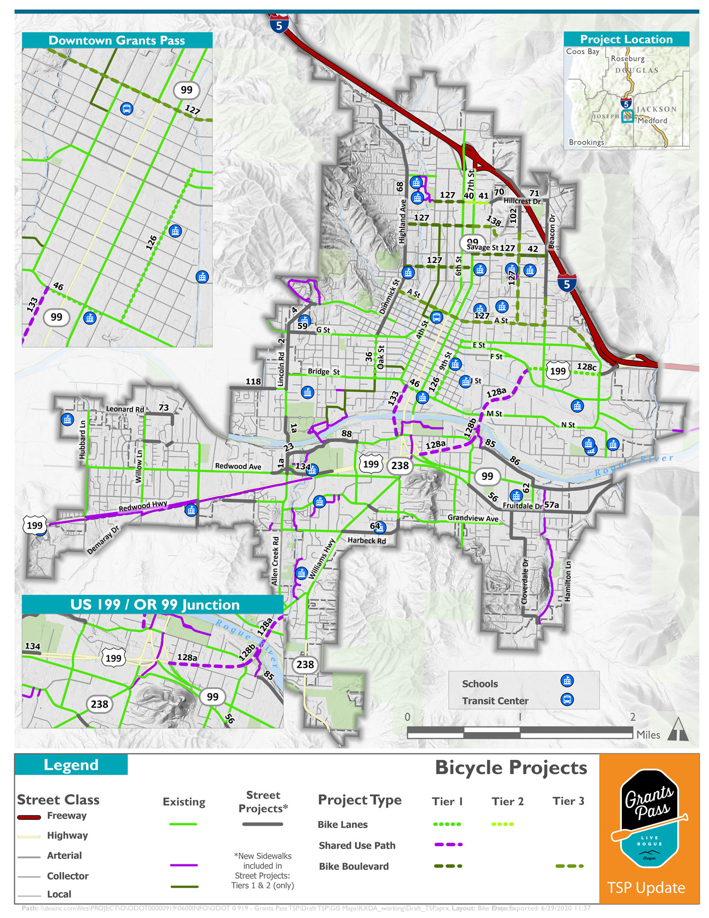
Click to enlarge image.
Questions
Exit 55


Proposed Projects
Exit 55 IAMP
Existing and future traffic volumes make it difficult for southbound I-5 off-ramp motorists to cross US 199 and turn south onto Agness Avenue. Either a new traffic signal or roundabout is needed at the junction of US 199 and the I-5 southbound off-ramp.
Exit 58 IAMP
No immediate or significant interchange improvement needs are identified in the Exit 58 IAMP area. The Grants Pass TSP Update will include recommended city code refinements that guide new east-west street connectivity (south of Morgan Lane) as part of the land development review process.
Exit 55
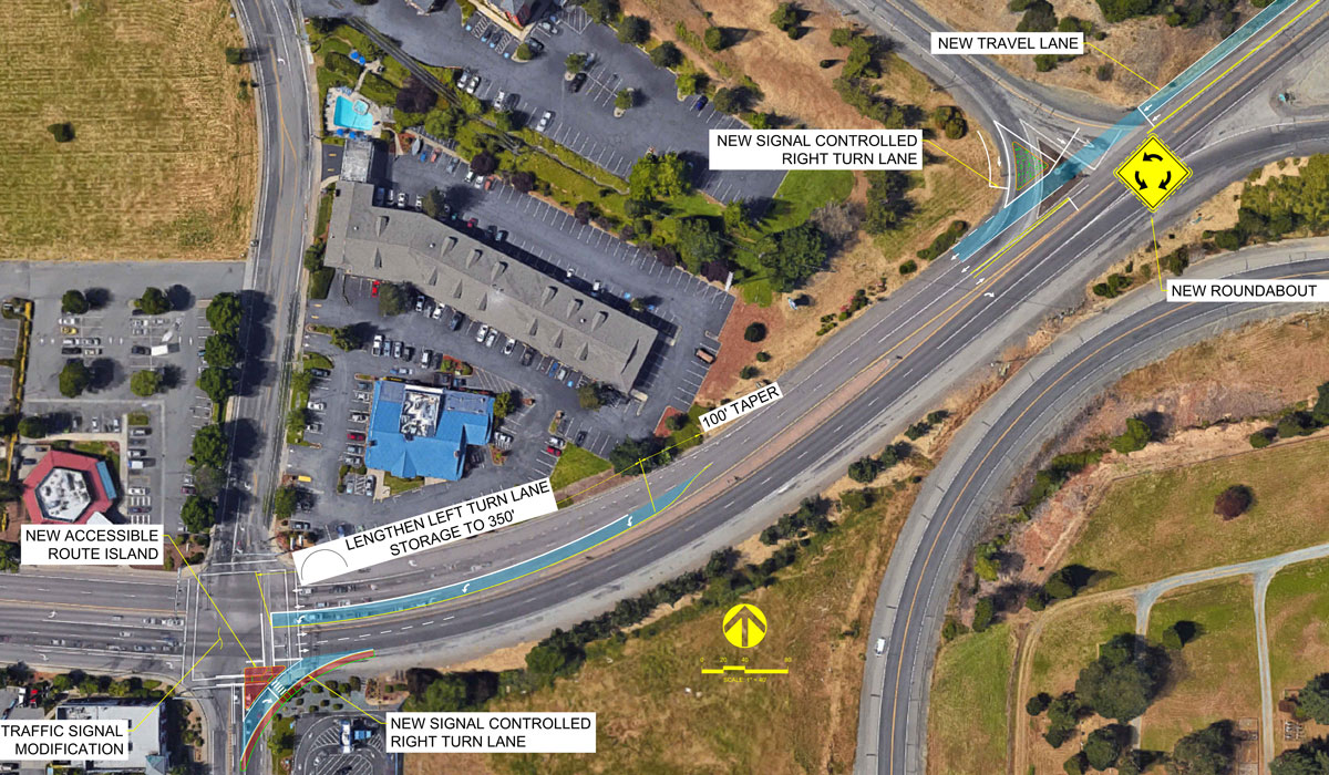
Click to enlarge image.
Questions
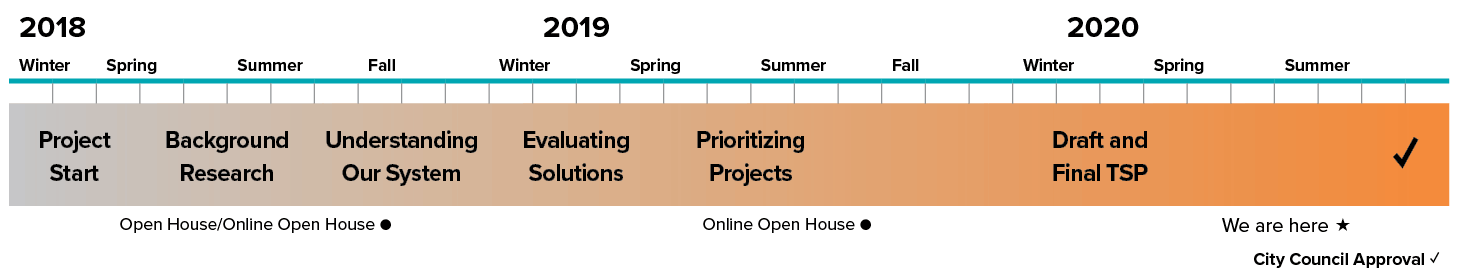
Project Schedule

Stay involved
- Learn more at grantspassoregon.gov/1201/Transportation-System-Plan
Timeline
Final questions
Before you leave, be sure to submit any comments you've provided.
