View the information on this site using the buttons below or click "Get Started" above to move through the content in order.

= Page includes questions or opportunities for comment.
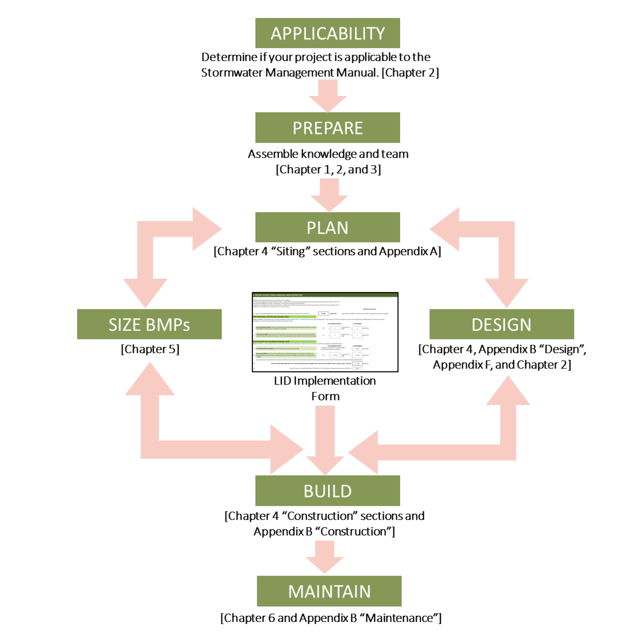
Using the Stormwater Management Manual
... Download the Manual (22 MB)
The SWMM provides detailed planning, design, construction, and maintenance information on best management practices (BMPs) that treat stormwater runoff on-site and reduce runoff volumes to protect water quality and reduce flooding downstream.
The last page of this online tool includes forms that can be used to determine which BMPs are necessary for a project.
WHAT IS LOW IMPACT DEVELOPMENT?
Also known as Green Infrastructure, Green Development Practices, or Alternative Storm Water Management Systems, LID is a pattern of land development that preserves natural resources and promotes managing stormwater where it falls. LID relies on carefully selected techniques for reducing, receiving and cleaning stormwater runoff to protect and improve water availability and quality.
The Puget Sound Partnership defines LID as “a stormwater and land use management strategy that strives to mimic pre-disturbance hydrologic processes of infiltration, filtration, storage, evaporation and transpiration by emphasizing conservation, use of on-site natural features, site planning and distributed stormwater management practices that are integrated into a project design.”
WHAT IS A BMP?
The EPA defines a best management practice (BMP) as "a device, practice, or method for removing, reducing, retarding, or preventing targeted stormwater runoff constituents, pollutants and contaminants from reaching receiving waters.”
Despite widespread use of “best,” these practices may not be effective unless properly applied:
- Use several BMPs together, not just one.
- Select BMPs appropriate for the site’s opportunities and constraints and for the project’s objectives.
- Apply BMPs during the appropriate phase(s) of the project. Some BMPs are important during more than one project phase.
You will learn more about specific BMPs later in this site.
WHY USE LOW IMPACT DEVELOPMENT?
- It can cost less to build and maintain.
- It reduces water pollution, which supports community health and welfare with better drinking-water quality, reduced treatment costs and cleaner waterways for recreation and commerce.
- It reduces local flooding during storms, except at sites with a history of flooding.
- It’s the most accepted path to meeting a community’s water quality goals as defined by an MS4 (National Pollutant Discharge Elimination System [NPDES] Municipal Separate Storm Sewer System) permit, or the Total Maximum Daily Load (TMDL) program.
In 2009 the EPA wrote, “Until recently, stormwater programs established to address water quality objectives have been designed to control traditional pollutants that are commonly associated with municipal and industrial discharges, e.g., nutrients, sediment and metals. Increases in runoff volume and peak discharge rates have been regulated through state and local flood control programs. Although these programs have merit, knowledge accumulated during the past 20 years has led stormwater experts to the conclusion that conventional approaches to control runoff are not fully adequate to protect the nation’s water resources.”
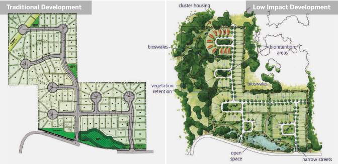
Traditional development versus low impact development patterns on a residential subdivision, where each site has 110 lots. Parcels are clustered to preserve valuable existing trees and reduce impervious areas, cut and fill are significantly reduced, and relatively small-scale, BMPs are distributed throughout the site to manage rainfall and runoff where it is generated.
READ MORE: Chapter 1 defines low impact development and its benefits, including the intersection of LID with Department of Environmental Quality (DEQ) regulations.
BMP SIZING METHODS
To design stormwater facilities, select either the Simplified Sizing Approach or the Engineered Design Approach. Each has a unique process to review and approve plans. Final selection of an approach is subject to City approval. The City may require a different approach upon review.
Some stormwater facilities require a specific approach. A combination of approaches may be used for a single project, but review and submittal requirements will be for the more intensive approach.
Simplified Sizing Approach
This approach is for projects with less than 10,000 square feet (0.23 acre) of total new or redeveloped impervious area on private property, including but not limited to roofs, concrete, asphalt, pavers, compacted gravel, compacted clay, plastic liners and clogged landscape fabric. The landowner or any other qualified, licensed professional or contractor may perform the sizing.
This approach is most appropriate for small-scale residential development, typically with limited professional design services. It is not allowed for:
- Large, complex projects
- Projects with multiple catchments totaling more than 10,000 square feet of new or redeveloped impervious area
- Projects that include a public right of way or are a Public Improvement (Municipal Code).
BMPs using this approach may require the Engineered Design Approach upon review by the City.
Engineered Design Approach
When any of the conditions for the Simplified Sizing Approach are not met, use the Engineered Design Approach. This approach may also be required as determined by the City Engineer. It requires a licensed engineer to design BMPs based on the criteria in Sections “Stormwater Management: Water Quality” and “Stormwater Management: Flow Control.” Submission of the Chapter 5 LID forms is not required with this approach.
Selecting an Approach
On this page is a "Sizing Methods" logic tree for selecting a sizing approach.
First determine if the manual applies based on the footprint of new or replaced impervious surface area. If the manual applies, select an approach.
If all the conditions in the “Simplified Sizing Approach” section and Chapter 2 requirements are met, the Simplified Sizing Approach may be used at the discretion of the City Engineer. Otherwise, use the Engineered Design Approach.
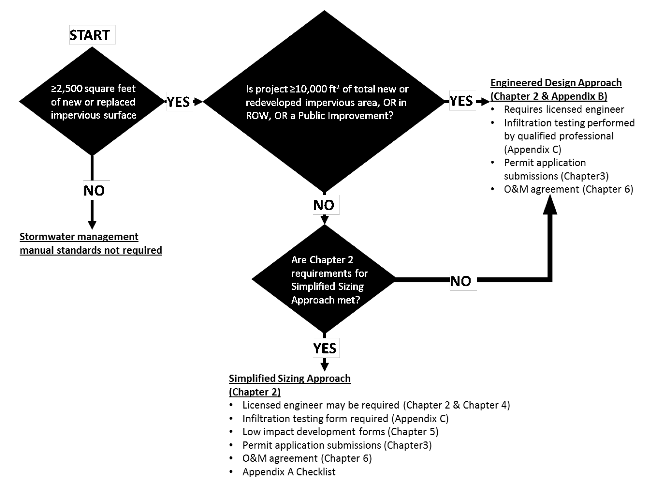
Logic tree for selecting sizing methods.
...READ MORE: Chapter 2 covers project applicability and how to meet landscaped area, water quality and flow control management requirements.
Site Planning Tools
This manual has three tools for site assessment and design.
Site Assessment Checklist. This is a comprehensive list of environmental, social and financial considerations for making decisions about best practices. Six steps, each with its own checklist items, are critical for planning:
- On-site natural resources
- On-site infrastructure/built environment
- Off-site natural resources
- Off-site infrastructure/built environment
- Municipal, state and federal guidelines/laws
- Programmatic requirements
BMP Suitability Matrix. This table guides gathering preliminary information to help choose appropriate BMPs based on natural conditions, land uses and water-quality considerations.
LID Implementation Form. This form steps through a preferred stormwater hierarchy, with the most preferred BMPs appearing first. The LID Worksheets help determine which information is most critical to implementing a BMP, and assist with its sizing.
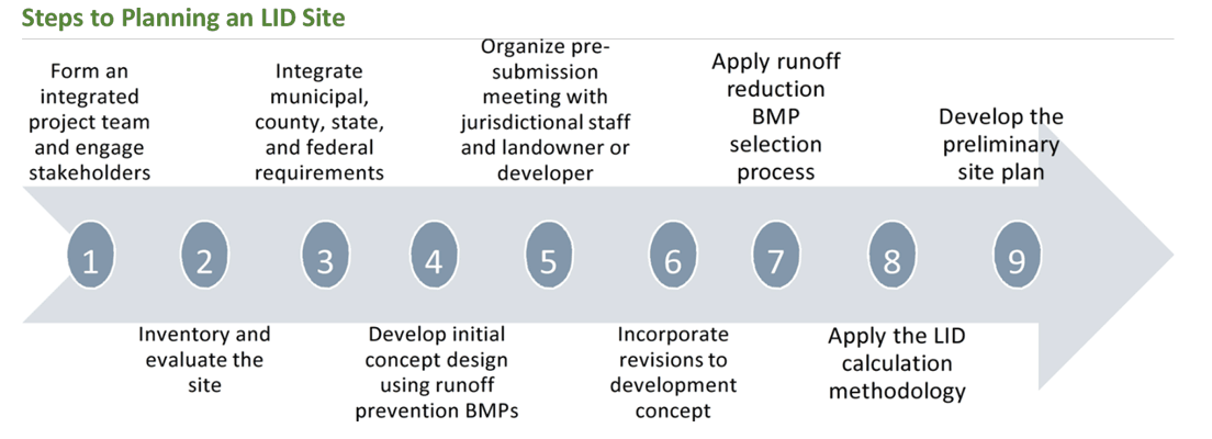
The LID site design process could be consolidated into nine basic steps.
READ MORE: Chapter 3 details LID site development through planning, design, construction and maintenance. Planners, designers, contractors and maintenance staff play unique but interwoven roles in impacting or protecting water quality.
Learn more about proposed BMPs and give feedback using the tabs below.
Water Quality indicates which BMPs address water quality on-site and which reduce runoff to protect against downstream erosion that re-pollutes waterways.
Drainage Area indicates which BMPs can be applied to which surfaces.
Challenging Sites indicates which BMPs are feasible where infiltration of runoff is not recommended.
Flow Control indicates which BMPs substitute for a detention basin, for flood control.
Land Use indicates the land uses and zoning classifications where LID can and has been implemented in Oregon.
Ownership indicates which BMPs may be used in private development or public development.
Development Type indicates which BMPs may be used in a retrofit, redevelopment or new development.
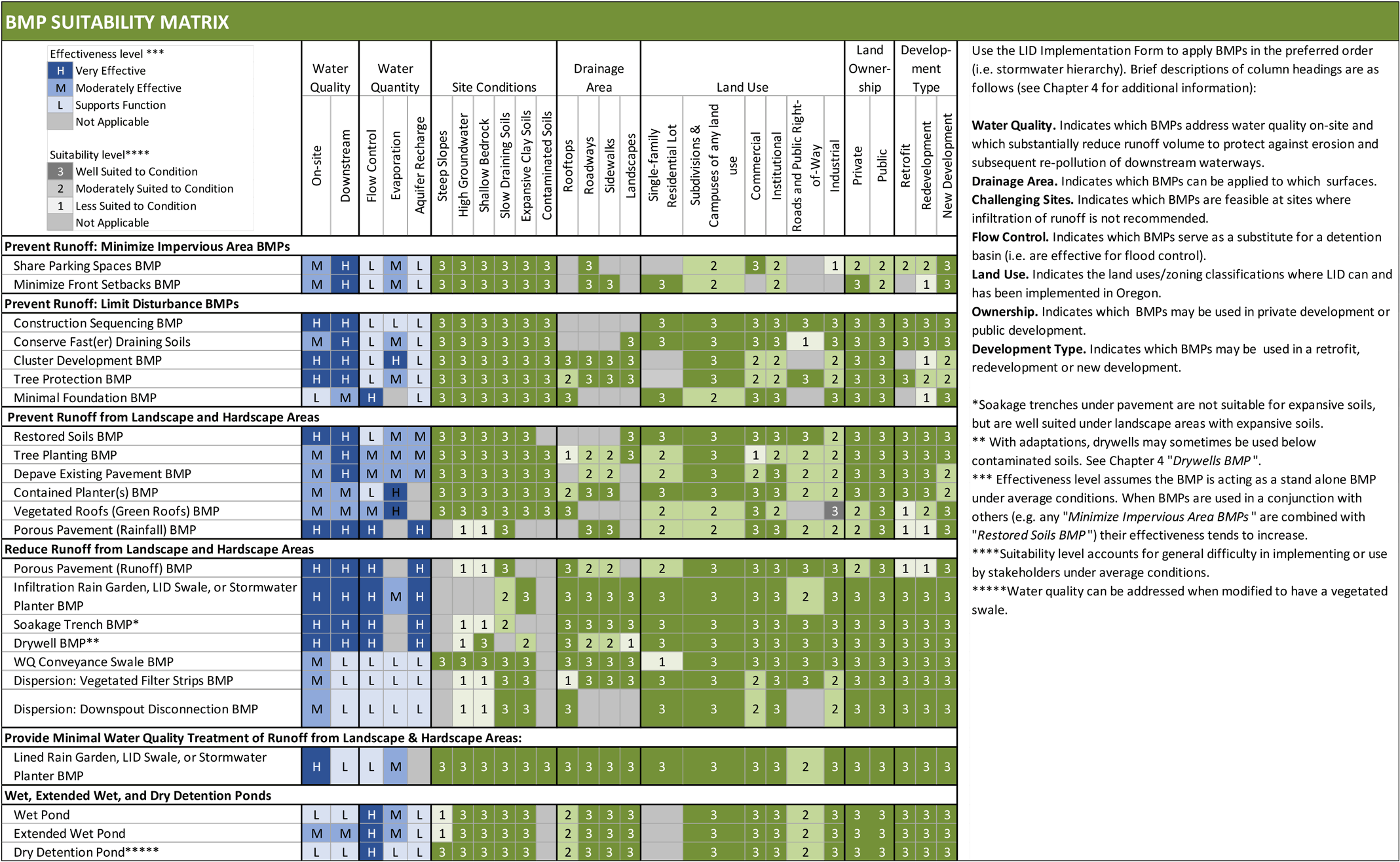
Click to enlarge. Use the BMP Suitability Matrix to identify potential BMPs in early planning. Consider printing this table out for easy reference when planning projects, and revisit it as the site plan changes.
OPERATIONS & MAINTENANCE
To function as intended over the long term, BMPs need maintenance. Private facilities such as rain gardens, stormwater planters and porous pavements on private property are the sole responsibility of the property owner. Before getting a development permit, the owner must sign an O&M agreement with the City (O&M Form), committing the owner and future owners to maintenance. This agreement is recorded with the deed during site-plan review.
The City is responsible for maintaining BMPs within public street rights-of-way and easements dedicated to the City. That responsibility includes removing trash, debris and sediment, along with repairing or replacing curbing, inlet drains and rock check-dams. The adjacent private-property owner is responsible for weeding, trimming or replacement of shrubs, grasses, or other plantings. Private-property owners must not place fill, trash, lawn trimmings, leaves or unapproved plants in public or private BMPs.
Conserving Fast(er) Draining Soils
Place impervious surfaces only on a site's slower draining areas. This conserves the faster draining soils, leaving them open to manage rainfall more effectively, and available for runoff-reduction BMPs. That allows such BMPs to be smaller, saving money during construction and during long-term maintenance. Read more about this BMP...
Does "Conserving Fast(er) Draining Soils" make sense in Grants Pass?
(Check one.)How do you feel about the operation and maintenance requirements related to "Conserving Fast(er) Draining Soils"?
(Check one.)Clustered Development
Place buildings and other infrastructure requiring road access together on a site, to reduce the total area of impervious surfaces. This can help with runoff prevention, runoff reduction, flood control and air quality (which helps water quality, since many water pollutants start out as airborne pollutants). Read more about this BMP...
Does "Clustered Development" make sense in Grants Pass?
(Check one.)How do you feel about the operation and maintenance requirements related to "Clustered Development"?
(Check one.)Protecting and Planting Trees
Protect individual trees and groves of trees. Groves can save more money and do more environmental good than scattered individual trees, but both are beneficial. Read more about this BMP...
Does "Protecting and Planting Trees" make sense in Grants Pass?
(Check one.)How do you feel about the operation and maintenance requirements related to "Protecting and Planting Trees"?
(Check one.)Minimal Excavation Foundations
Use minimal-excavation foundations, such as pier foundations. In undeveloped watersheds, some rain soaks into the ground and flows through voids in the soil (even dense clay soils), seeping downhill to keep waterways flowing days, weeks and sometimes months after rainfall. Basements and slab-on-grade foundations fill the soil voids, increasing both runoff and the likelihood of flooding. Read more about this BMP...
Does "Minimal Excavation Foundations" make sense in Grants Pass?
(Check one.)How do you feel about the operation and maintenance requirements related to "Minimal Excavation Foundations"?
(Check one.)Sequenced Construction
Specify a schedule that coordinates land-disturbing work with installing erosion prevention and sediment control (EPSC) measures. The goal is to prevent erosion and control sediment by minimizing how much land is cleared at one time and by installing EPSC measures before land clearing begins. Read more about this BMP...
Does "Sequenced Construction" make sense in Grants Pass?
(Check one.)How do you feel about the operation and maintenance requirements related to "Sequenced Construction"?
(Check one.)Shared Parking Spaces
In commercial districts, consider sharing off-street parking with another organization that has different peak hours. Read more about this BMP...
Does "Shared Parking Spaces" make sense in Grants Pass?
(Check one.)How do you feel about the operation and maintenance requirements related to "Shared Parking Spaces"?
(Check one.)Minimized Front Setbacks
The closer a building is to the street, the shorter the driveway and sidewalk — thus minimizing impervious area. Read more about this BMP...
Does "Minimized Front Setbacks" make sense in Grants Pass?
(Check one.)How do you feel about the operation and maintenance requirements related to "Minimized Front Setbacks"?
(Check one.)Shared Driveway
A shared driveway for multiple buildings reduces impervious area, compared to each building having its own driveway. Read more about this BMP...
Do "Shared Driveways" make sense in Grants Pass?
(Check one.)How do you feel about the operation and maintenance requirements related to "Shared Driveways"?
(Check one.)Depaving
Depaving — tearing out pavement and replacing it with landscaping — reduces the runoff from a developed site by allowing rainfall to infiltrate and evaporate. It also makes room for runoff BMPs such as rain gardens. Key steps for depaving appear in Appendix A. Read more about this BMP...
Does "Depaving" make sense in Grants Pass?
(Check one.)How do you feel about the operation and maintenance requirements related to "Depaving"?
(Check one.)Restored Soil
Amend disturbed soils to make them water-permeable again. Any site in a historically populated area is likely to have compaction and loss of topsoil, from vehicle traffic or even foot traffic. (See Chapter 3.) Restoring it can be simple and cost-effective. Along with preventing runoff, soil restoration also conserves water and reduces the need to use pesticides, herbicides and fertilizers. Read more about this BMP...
Does "Restored Soil" make sense in Grants Pass?
(Check one.)How do you feel about the operation and maintenance requirements related to "Restored Soil"?
(Check one.)Contained Planters
Place contained planters over impervious areas on the ground or roof. They intercept rainfall and evaporate it back into the air, even in winter. Acting much like vegetated roofs, contained planters can reduce annual runoff by 40 to 60 percent while also improving aesthetics. Consider placing them on unused pavement as an alternative to depaving. Read more about this BMP...
Does "Contained Planters" make sense in Grants Pass?
(Check one.)How do you feel about the operation and maintenance requirements related to "Contained Planters"?
(Check one.)Tree Planting
Plant new trees. Trees benefit both water quantity and water quality. (See Chapter 1.) They can also screen off conflicting uses, improve livability and health, reduce energy demand through windbreaks and shading and express a community’s historical and cultural identity. The benefits of new trees are often small when first planted, but they accrue over time. Proper tree planting is essential to trees’ long-term survival, health and safety. Read more about this BMP...
Does "Tree Planting" make sense in Grants Pass?
(Check one.)How do you feel about the operation and maintenance requirements related to "Tree Planting"?
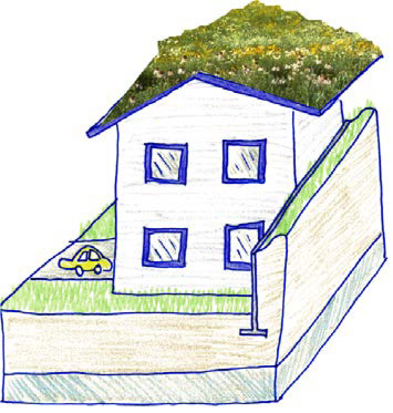
(Check one.)Vegetated Roofs (Green Roofs)
Consider vegetated roofs. These roof-system assemblies manage stormwater by holding rainfall in the pores of a growing medium and in a drainage layer below (if used), for use by plants. “Green roof” is the more commonly used term, but "vegetated roof" is more appropriate for dry summers in Grants Pass, where some plants are dry and inactive until the rainy season. Read more about this BMP...
Do "Vegetated Roofs" make sense in Grants Pass?
(Check one.)How do you feel about the operation and maintenance requirements related to "Vegetated Roofs"?
(Check one.)Porous Pavement
Consider porous pavement, also known as permeable or pervious pavement. It allows water to move through voids within the pavement surface and through rock below, infiltrating underlying soils. It can be used to intercept rainfall or to manage runoff from other areas. It can accommodate both vehicular and pedestrian traffic, in many cases. See Table 4-4 for applications. Read more about this BMP...
Does "Porous Pavement" make sense in Grants Pass?
(Check one.)How do you feel about the operation and maintenance requirements related to "Porous Pavement"?
(Check one.)Rain Garden
A rain garden has gentle side slopes and may be any shape (round, kidney, etc.). It should be installed on flat ground (finish grade slopes generally less than 1 percent or where no more than a difference of 0.5 inch of ponded water would occur).It has a single area where water is ponded before it infiltrates — or in large storms, overflows. Read more about this BMP...
Do "Rain Gardens" make sense in Grants Pass?
(Check one.)How do you feel about the operation and maintenance requirements related to "Rain Gardens"?
(Check one.)LID Swale
An LID swale has gentle side slopes but is linear in shape. It can be installed on sloping areas, using check dams that allow water to back up (similar to rain gardens). Each cell created by the check dam ponds up before water cascades over the check dam and into the next cell, infiltrating and evaporating along the way. At the last cell at the bottom of the LID swale, stormwater finally may overflow. The centerline of a swale cell should slope 1 percent or less. Read more about this BMP...
Do "LID Swales" make sense in Grants Pass?
(Check one.)How do you feel about the operation and maintenance requirements related to "LID Swales"?
(Check one.)Stormwater Planter
A stormwater planter may be either above- or in-ground. It has vertical sides created by deep curbs (in ground), walls or a container (free-standing/above ground) instead of gentle side slopes. It can be any shape. Those above-ground tend to be square or rectangular. It may be installed on flat areas (finish-grade slopes generally less than 1 percent or where no more than a difference of 0.5 inch of ponded water would occur). It may be installed on sloping ground, with check dams to create a series of cells where overflow may occur in the lowest-elevation cell. Read more about this BMP...
Do "Stormwater Planters" make sense in Grants Pass?
(Check one.)How do you feel about the operation and maintenance requirements related to "Stormwater Planters"?
(Check one.)Soakage Trench
Soakage trenches — also called infiltration trenches and recharge beds — are excavated trenches filled with coarse stone (storage rock) and wrapped in geotextile. They receive runoff though a pipe and store it in the rock voids until it infiltrates surrounding soils.
The EPA defines soakage trenches as an assemblage of perforated pipes, drain tiles or similar that distribute fluids below the ground surface. The primary difference between a soakage trench and a vegetated stormwater facility is that water is injected underground though a pipe, rather than infiltrating the soil surface.
Soakage trenches can underlie surfaces such as parking areas on porous or impervious pavement, lawns and perennial groundcover or shrub areas. They manage stormwater invisibly but cost more to maintain. Read more about this BMP...
Do "Soakage Trenches" make sense in Grants Pass?
(Check one.)How do you feel about the operation and maintenance requirements related to "Soakage Trenches"?
(Check one.)Drywell
A drywell can be a shaft, an assemblage of perforated pipes, or a collection of drain tiles that receive runoff from impervious surfaces and infiltrate it underground. Drywells reduce runoff flow rates and volumes but have limited storage capacity, so they are generally installed in fast-draining soils such as buried gravelly and sandy flood deposits.
Because drywells are underground injection control (UIC) devices, they require authorization from Oregon DEQ. (See UIC Authorization.) In all but residential roof drainage areas, this requires pretreating discharge water before directing it to a drywell.
Drywells have fewer benefits than other measures. Use other LID techniques such as rain gardens, planters and porous pavements before implementing drywells. Read more about this BMP...
Do "Drywells" make sense in Grants Pass?
(Check one.)How do you feel about the operation and maintenance requirements related to "Drywells"?
(Check one.)Water Quality Conveyance Swale
Water quality (WQ) conveyance swales are linear, vegetated, channeled depressions that convey and treat runoff. Runoff may be piped or channeled, or flow overland to a swale. These can be used where ponded water might be considered a hazard, such as near highways. Read more about this BMP...
Do "Water Quality Conveyance Swales" make sense in Grants Pass?
(Check one.)How do you feel about the operation and maintenance requirements related to "Water Quality Conveyance Swales"?
(Check one.)Dispersion
Dispersion spreads runoff over a landscape area, reducing pollution as well as runoff volume. Dispersion is suitable for many roadside applications and development densities. However, denser development has less setback of structures from the road — which, unless structures are clustered, reduces the size of dispersion areas and the amount of water they can disperse. (See Chapter 4.) Read more about this BMP...
Does "Dispersion" make sense in Grants Pass?
(Check one.)How do you feel about the operation and maintenance requirements related to "Dispersion"?
(Check one.)Wet Pond
Wet ponds have a permanent pool of water, also called pool storage or dead storage. Stormwater enters the pond at one end and displaces water from the permanent pool. Pollutants are removed from newly arrived stormwater through gravitational settling and biological processes.
When criteria for the Engineered Design Approach (see Chapter 2) are followed, water quality requirements are presumed to be met. To meet applicable flow-control requirements, additional facilities may be required. Read more about this BMP...
Do "Wet Ponds" make sense in Grants Pass?
(Check one.)How do you feel about the operation and maintenance requirements related to "Wet Ponds"?
(Check one.)Extended Wet Pond
Extended wet ponds also have a permanent pool of water, but have additional storage above that fills during storms and releases water slowly — over a number of hours. The permanent pool is sized to reduce pollution through gravitational settling and biological processes, while the additional storage above (also called the extended detention area) is sized to meet flow-control requirements.
When criteria for the Engineered Design Approach (see Chapter 2) are followed, water quality requirements are presumed to be met. The extended detention must be designed using acceptable hydrologic modeling techniques (see Appendix B and Chapter 2) to meet applicable flow-control requirements. Read more about this BMP...
Do "Extended Wet Ponds" make sense in Grants Pass?
(Check one.)How do you feel about the operation and maintenance requirements related to "Extended Wet Ponds"?
(Check one.)Dry Detention Pond
Dry detention ponds fill during storms and release water over a number of hours. They must be designed using acceptable hydrologic modeling techniques (see Appendix B) to meet applicable flow control requirements. Additional facilities are required to meet water quality requirements unless the bottom flow path of the pond is designed as a swale according to criteria for swale sizing and design. Read more about this BMP...
Do "Dry Detention Ponds" make sense in Grants Pass?
(Check one.)How do you feel about the operation and maintenance requirements related to "Dry Detention Ponds"?
(Check one.)Read More
Chapter 4 provides detailed guidance for each BMP through the planning, design, construction and maintenance project phases, as well as BMP-specific cost considerations. A quick-reference table shows what each BMP can manage, what sizing approaches can be used and if infiltration testing is required.
Chapter 6 explains how to complete and file the Operations and Maintenance Agreement Form, which documents who will be responsible for BMP maintenance, what specific maintenance is needed, where the BMPs are located, and legal language.
STORMWATER MANAGEMENT HIERARCHY
Choose BMPs based on their ability to mimic pre-development hydrology, following the preferred hierarchy:
- Lay out the site to minimize impacts to natural resources and to minimize impervious areas.
- Prevent runoff by intercepting, evaporating and/or infiltrating rainfall.
- Reduce runoff using BMPs with surface storage (such as ponding) that infiltrate and to a lesser extent, intercept and evaporate runoff and the rainfall they receive.
- Reduce runoff using BMPs with underground storage that infiltrate runoff.
- Reduce runoff using flow-based BMPs without storage (i.e. conveyance) that infiltrate lower volumes and to a lesser extent, intercept and evaporate runoff and rainfall.
- If the first five choices are not feasible, then the only remaining LID choice is to improve the water quality of runoff without significantly reducing the volume, using a lined BMP or proprietary device. This is not preferred. (See Chapter 1.)
- To manage stormwater water quality and flow control on larger sites when LID facilities are not sufficient, use a Wet Pond, Extended Wet Pond, or Dry Detention Pond. (See Chapter 4.) Consider steps 1-6 before using ponds, especially at sites with higher infiltration rates.
LID IMPLEMENTATION FORM REQUIREMENTS
Complete the LID Implementation Form at the beginning of a project, during site planning. Revisit it when detailing a set of plans for construction.
If using the Simplified Sizing Approach to design BMPs, submit all LID Forms for the permit application package:
- Project Summary Form
- LID Forms A through C once.
- LID Forms D through J for each basin
- A relevant Worksheet for each BMP
Refer to Chapter 3 for further requirements.
If using the Engineered Design Approach to design BMPs, LID Forms and worksheets are not required. The permit application package should include the following along with a drainage report:
- Information on project summary form
- Any sizing factors used to design BMPs on-site
Refer to Chapter 3 for further requirements.
Example runoff prevention BMPs applied to a single-family home:
- Minimize Building Footprint (with a two-story house, impervious area reduced)
- Minimize Front Setbacks (impervious area reduced)
- Vegetated Roof BMP (50% prevented, 50% runoff)
- Restored Soils to lawn BMP (100% managed)
- Porous Pavement (Rainfall) BMP (100% prevented)
...READ MORE: Chapter 5 explains how to complete the LID Implementation Forms (Excel format), which define a hierarchy of BMPs and steps the planner or designer can use to size BMPs.
Some sites could generate pollutants that stormwater quality measures would not address. They have characteristics and uses involving oil and grease, toxic hydrocarbons, heavy metals, toxic compounds, solvents, abnormal pH levels, nutrients, organics, bacteria, chemicals or suspended solids. This chapter presents source controls for managing such pollutants at their source.
Industrial facilities may be subject to additional requirements through State of Oregon NPDES permits or as outlined in Oregon Administrative Rules (OAR) 340 Division 041. The Municipal Code has lists of prohibited discharges to the City’s storm sewer system.
The requirements and implementation of this chapter is in additionto applicable water-quality and flow-control requirements.
Applicants may propose alternatives to the source controls identified in this chapter, with an additional review process.
Site Uses and Characteristics That Trigger Source Controls
Projects with the following site uses and characteristics are subject to the design methodologies of this chapter:
- Fuel dispensing facilities and surrounding traffic areas
- Above-ground storage of liquid materials
- Solid-waste storage areas, containers and trash compactors
- Outdoor storage of bulk materials
- Equipment and/or vehicle washing facilities
- Stormwater and groundwater management for development on land with suspected or known contamination
Applicants are required to address all the site characteristics and uses listed in this chapter. For example, if a development includes both a fuel dispensing area and a vehicle washing facility, the source controls in both sections will apply.
READ MORE: Chapter 6 presents on-site source controls for managing site specific sources of pollutants. Implementation of this chapter is in addition to the required water quality and flow control measures.
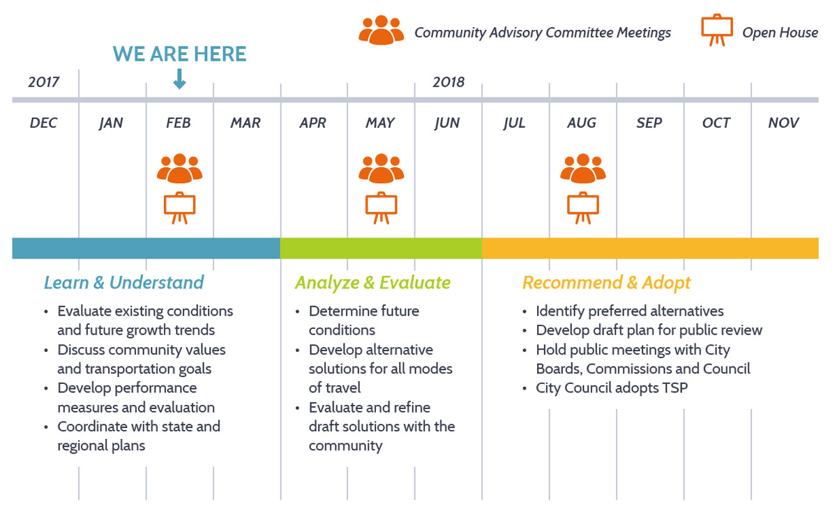
Project Schedule


For more information
- Sign up for project notices below.
- Contact Wade Elliott, City of Grants Pass Public Works
(541) 450-6110 welliott@grantspassoregon.gov. - Visit the project website at grantspassoregon.gov.
Final questions
Before you leave, be sure to submit any comments you've provided.
Tell us about you...
This information helps us understand who is interested in this process.
