
Project Information
- Open House Guide (pdf, 245 K)
- January 2018 Newsletter (pdf, 850 K)
- Technical Memos (LINK)
Open House Stations

= Page includes questions or opportunities for comment.
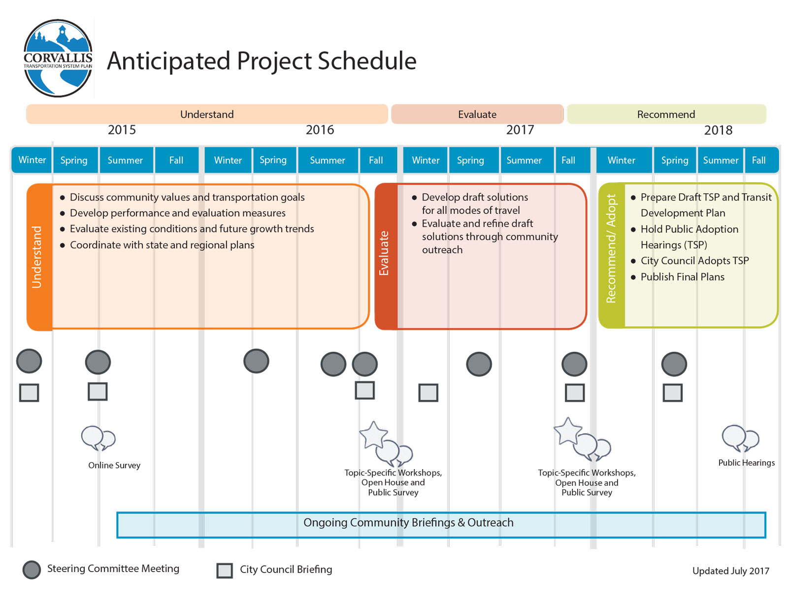
Anticipated Project Schedule


Anticipated Funding
- TSP Funding: There are more than $1 billion in transportation system improvements proposed as part of this Transportation System Plan (TSP) update. The City of Corvallis will have approximately $42 million to spend on projects from the TSP through the year 2040, after maintenance and operations costs are covered. Funding sources of future improvements may include the developers, the City, County, and State. Cost, in addition to stakeholder input and evaluation results, will factor into the City's final prioritized project list.
- Transit Funding: HB 2017 will provide the City with additional transit revenue for operating and capital needs. Initial projections estimate $1-$2 million per year for the City.
How Proposed Solutions Were Developed and Evaluated
The recommended transportation solutions were based on the project goals and objectives and input from three main sources:
- Stakeholder input
- Previous plans (such as the 1996 TSP and area plans for North, South, and West Corvallis)
- Technical evaluation (Technical Memoranda #7 and #12)
The solutions were compared to a set of evaluation criteria. The criteria were developed directly from the project goals and objectives and are intended to see how strongly each solution supports community-expressed interests.
Evaluation Criteria
Evaluation Criteria
- Significantly reduces vehicle-miles traveled (VMT)
- Improves the performance of a substandard intersection
- Significantly improves travel time on a freight route during the PM peak
- Significantly improves percentage of households and employment in close proximity to high quality pedestrian or bicycle facilities
- Significantly improves percentage of households and employment near (within ¼-mile) transit service served by at least 30 transit vehicles per day
+ Goal 2: Provide a transportation system that enhances the health and safety of residents.
Evaluation Criteria
- Provides a bicycle facility on an arterial or collector roadway
- Provides a pedestrian facility on an arterial or collector roadway
- Improves a recognized safety issue
- Improves safety for vulnerable users
Evaluation Criteria
- Improves span and frequency of transit service by route classification
- Improves percent of collectors and higher roadway mileage with transit service served by at least 30 transit vehicles per day
- Reduces the bicycle level of traffic stress
- Reduces the pedestrian level of traffic stress on arterial/ collector segments
- Improves pedestrian network quality at arterial/collector intersections
- Significantly improves percentage of households and employment near (within 1/4-mile) transit service served by at least 30 transit vehicles per day
Evaluation Criteria
- Focuses on travel demand management or existing transportation system management
- Provides a bicycle facility on an arterial or collector roadway
- Provides a pedestrian facility on an arterial or collector roadway
- Improves safety for vulnerable users
- Encourages increased travel by transit
- Significantly reduces vehicle-miles traveled (VMT)
Provide Your Input
Proposed solutions have been rated as "High, Medium, or Low" priority based on the number of evaluation criteria met.
These initial ratings will be reviewed after consideration of public input through the Open House.
Review the projects, then give feedback
Click the tabs below to browse the potential projects as a map or searchable list, then answer the questions.
 button in the upper left corner of the map window. You may need to turn off layers with large map objects to select other objects beneath.
(The projects shown on this map are the same as shown in the project list.)
The map should be considered a high-level overview of potential projects; it is not intended to provide precise or final locations of projects or alignments.
(The projects listed in this table are the same as shown on the project map.)
Review the evaluation results for the auto/freight projects and please provide your input.
(Check one.)Of the auto/freight projects evaluated, which ones best support driving in Corvallis?
(Choose up to 10 priority projects. Refer to the list of projects on the previous tabs for more information.)
Review the projects, then give feedback
Click the tabs below to browse the potential projects as a map or searchable list, then answer the questions.
(The projects shown on this map are the same as shown in the project list.)
The map should be considered a high-level overview of potential projects; it is not intended to provide precise or final locations of projects or alignments.
(The projects listed in this table are the same as shown on the project map.)
Review the evaluation results for the pedestrian projects and please provide your input.
(Check one.)Of the pedestrian projects evaluated, which ones best support walking in Corvallis?
(Choose up to 10 priority projects. Refer to the list of projects on the previous tabs for more information.)
Review the projects, then give feedback
Click the tabs below to browse the potential projects as a map or searchable list, then answer the questions.
(The projects shown on this map are the same as shown in the project list.)
The map should be considered a high-level overview of potential projects; it is not intended to provide precise or final locations of projects or alignments.
(The projects listed in this table are the same as shown on the project map.)
Review the evaluation results for the bike projects and please provide your input.
(Check one.)Of the bike projects evaluated, which ones best support biking in Corvallis?
(Choose up to 10 priority projects. Refer to the list of projects on the previous tabs for more information.)


Summary of Route Changes
(Click each for more information.)
- A - Restructure Routes 1, 4 and 7
- Shorten Route 1 to improve reliability. Discontinue Routes C1/C1R and add resources to Routes 1 and 5.
- Add Timberhill Shopping Center to Route 7.
- Reduce amount of service to Good Samaritan Hospital and Hewlett-Packard. Discontinue Route C2.
- Add strong market to Route 4 (Conser/Conifer). Provide more direct service from Conser/Conifer to downtown.
- B - Service adjustments at Timberhill Shopping Center
- Shorten Route 1 to improve reliability.
- Add Timberhill Shopping Center to Route 7.
- C - New crosstown service
- Add Route 9 between Walnut Boulevard and Witham Hill Drive, along Witham Hill Drive, Grant Avenue, Buchanan Avenue, 5th Street, to Downtown Corvallis.
- D - New service area
- Realign Route 1 after Circle Boulevard extension is completed to serve future development.
- E - Market CVA to general public
- Rename to Route 11. Modify routing.
- F - Service adjustments on Harrison Boulevard and 53rd Street
- Discontinue Route C3.
- Extend Route 8 to serve Grand Oaks.
- G - Service adjustments in Southwest Corvallis
- Realign Route 8 to provide bi-directional service on Country Club Drive.
- Modify Routes 3 and 8 along 49th Street and 53rd Street to operate in consistent direction.
- H - Add frequency to Route 3
- Realign Route 3 outbound trips on OSU’s campus onto Washington Way (after roadway improvements)
- I - Improve transit access to Downtown
- Add Route 10 from Downtown Transit Center, serving 5th Street, Van Buren Avenue, 2nd Street and Western Boulevard.
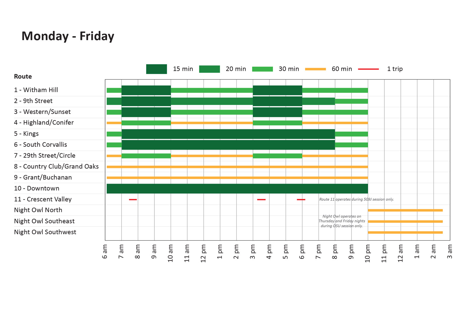
Frequency and Service Hours
Monday - Friday
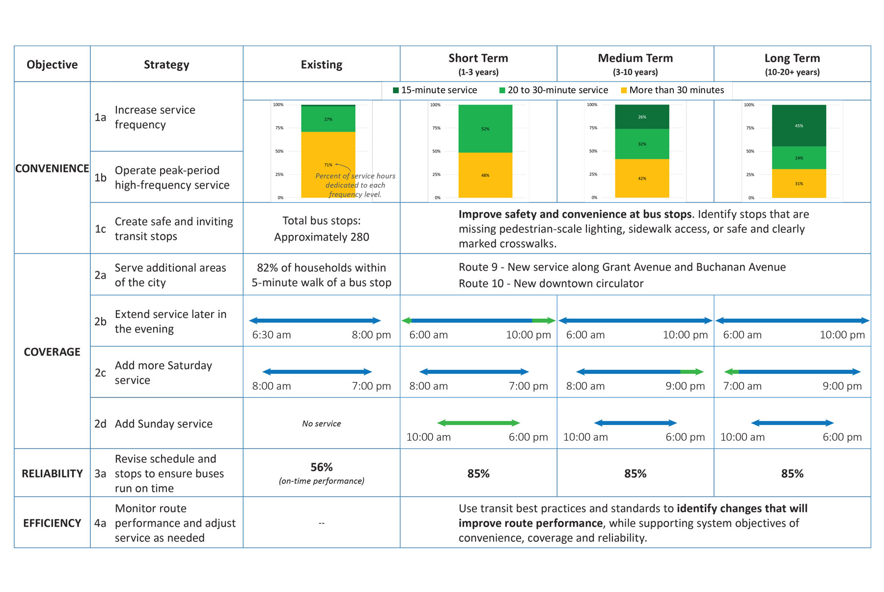
- Routes 1 - 10 operate 6 am to 10 pm (currently 6:30 am to 8 pm)
- High-frequency service on high demand routes: 15-20 minutes all day on Routes 2, 5, 6 and 10
- Peak-Hour Frequency: 15-minute peak service on Routes 1, 2 and 3
- More frequent all-day service on Routes 4 and 7
- All routes – except for Night Owl and Route 11 – will operate all year round
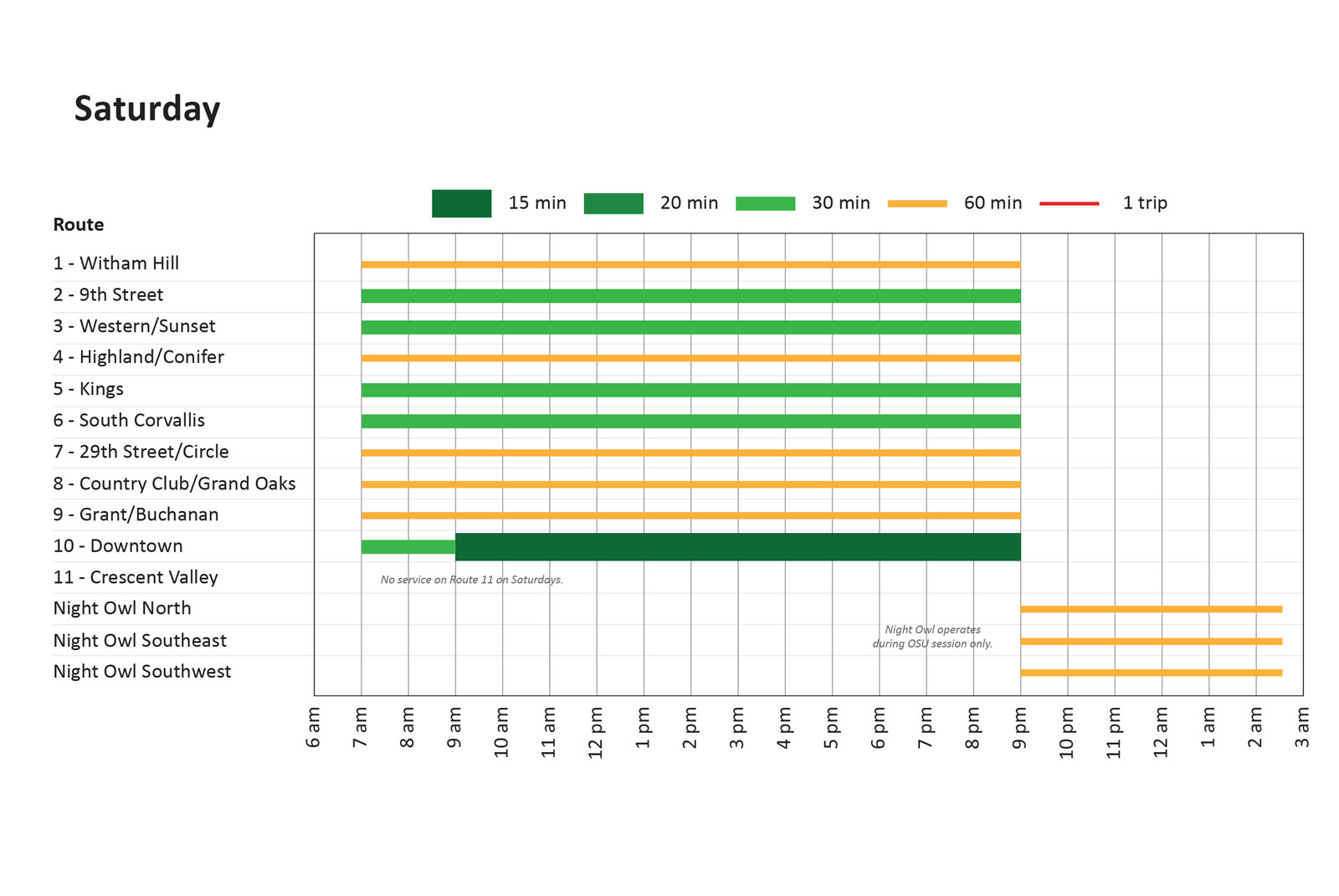
Saturday
- Routes 1 - 10 operate 7 am to 9 pm
- Routes 2, 3, 5, 6 and 10 operate at least every 30 minutes all day
- Routes 1, 4, 7, 8 and 9 operate every hour
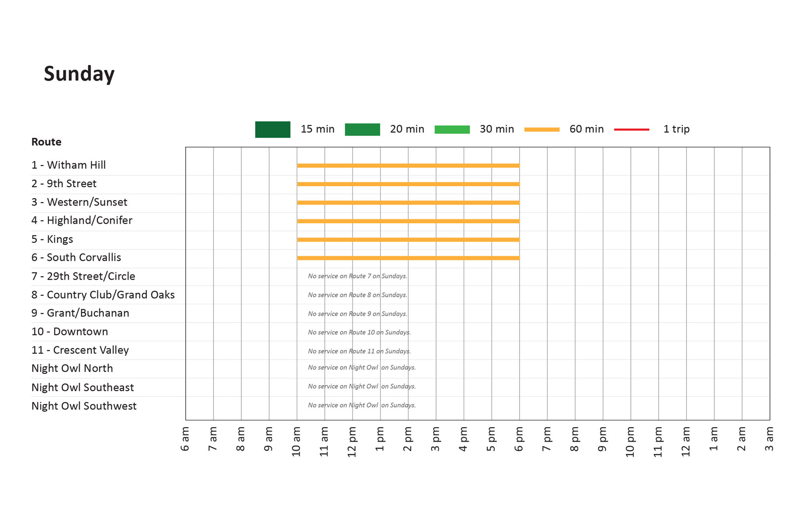
Sunday
- Routes 1 - 6 operate 10 am to 6 pm
- Service operates every hour
Questions
Do you agree that the proposed changes to the transit routes, frequency and service hours will meet public transportation needs in Corvallis?
(Check one.)Consider the following transit strategies:
- Adding frequency to weekday routes all day
- Adding frequency to weekday routes during rush hour
- Earlier service in the morning on weekdays
- Later service in the evening on weekdays
- More service on Saturdays
- Adding Sunday service
- Keeping buses on time
- Expanding to serve more areas of the city
Which transit strategies are your highest priority?
(Choose three.)Comment
- Submit your comments using the form below.
- Visit www.CorvallisTSP.org to provide comments anytime.
- Email: info@CorvallisTSP.org.
- Contact the Project Manager: Adam Steele, Corvallis Public Works Project Manager at (541) 766-6916 or adam.steele@corvallisoregon.gov
Stay Informed
- Sign up for the mailing list below.
Final Questions
Tell us about yourself
Mailing list
Provide your contact information if you would like to be added to the project mailing list. (Optional.)Demographic Questions (Optional)
Before you leave, be sure to submit any comments you've provided. (The option to review and submit answers will appear after you answer at least one question.)
