
Visit the pages on this site using the buttons below or click "Get Started" to move through the information in order.
Stations

= Page includes questions or opportunities for comment.
Last year, in response to direction from the Governor and requests from local project stakeholders, the Oregon Transportation Commission directed the Oregon Department of Transportation to retain a consultant team of local and national urban design, engineering, and environmental experts to conduct an independent assessment of the highway cover designs included in the I-5 Rose Quarter Improvement Project. The requests from Metro, Multnomah County, City of Portland, Portland Public Schools and Albina Vision Trust shaped the creation of the independent cover assessment process.
Image gallery contents:
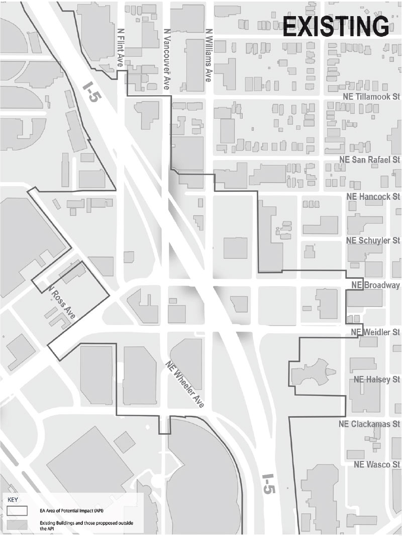
Existing Conditions
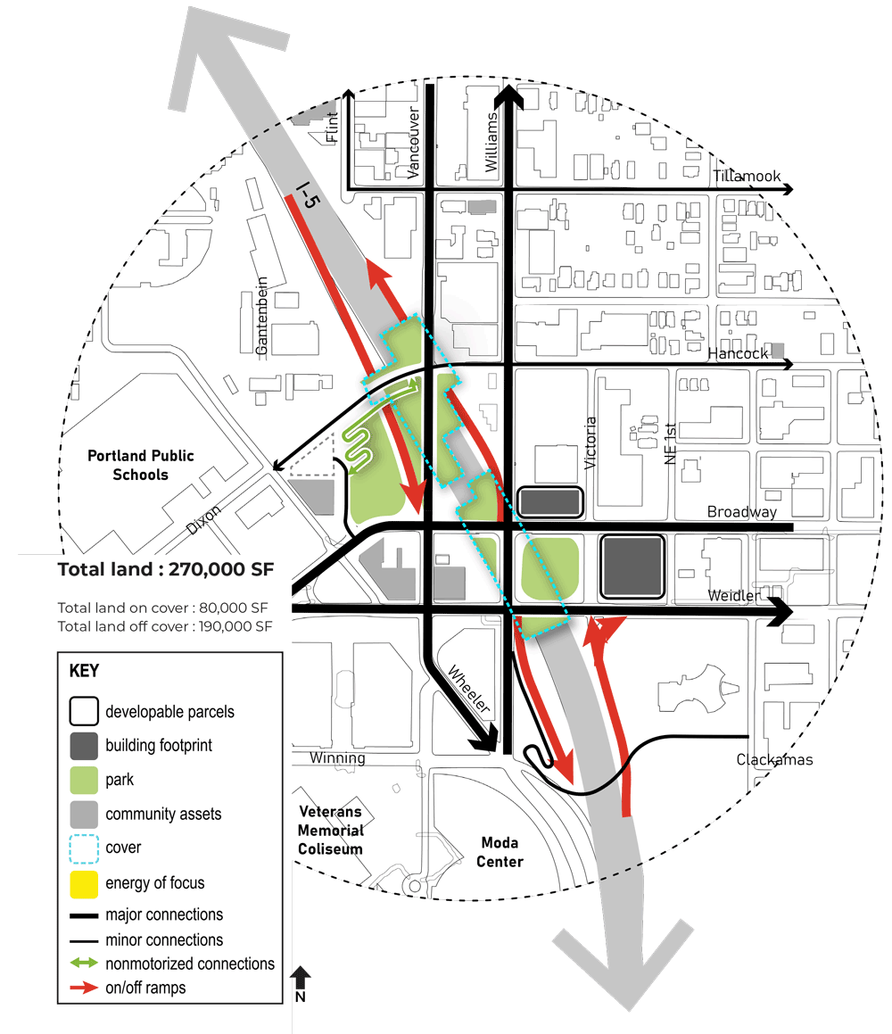
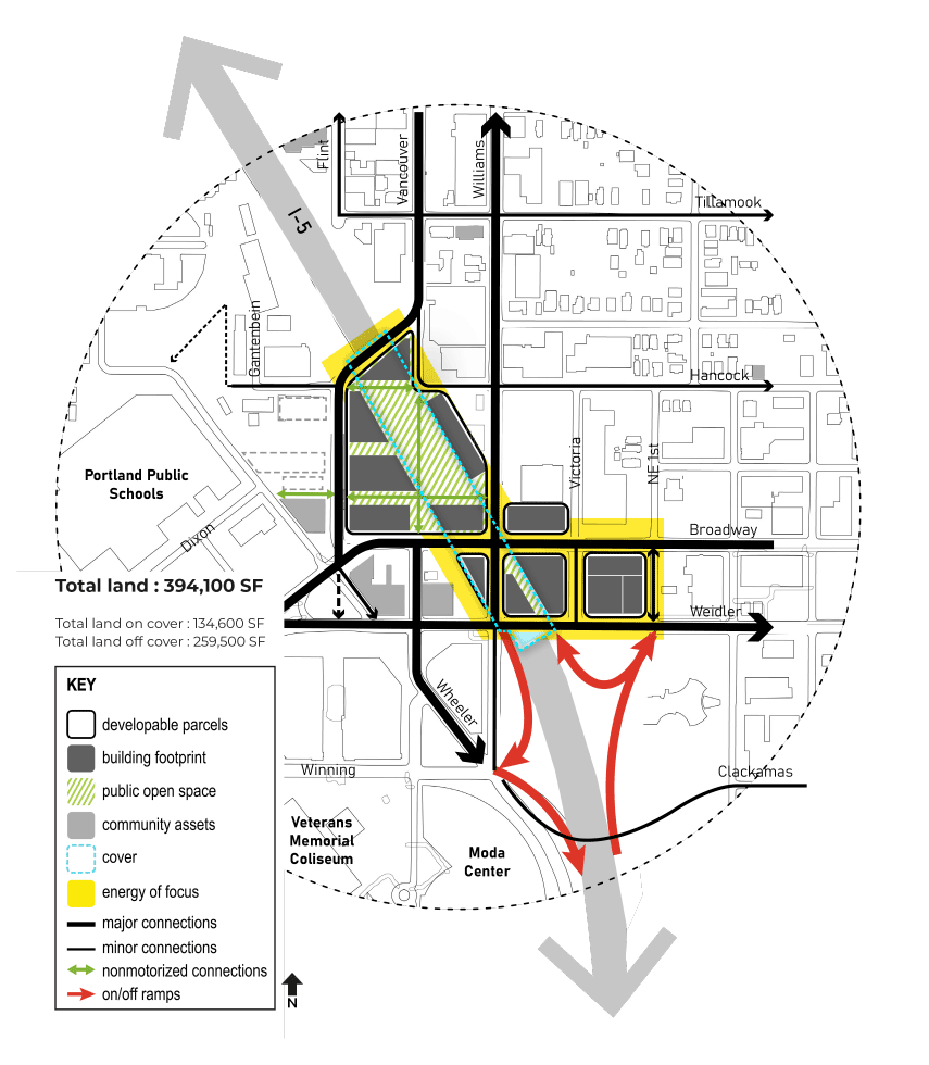
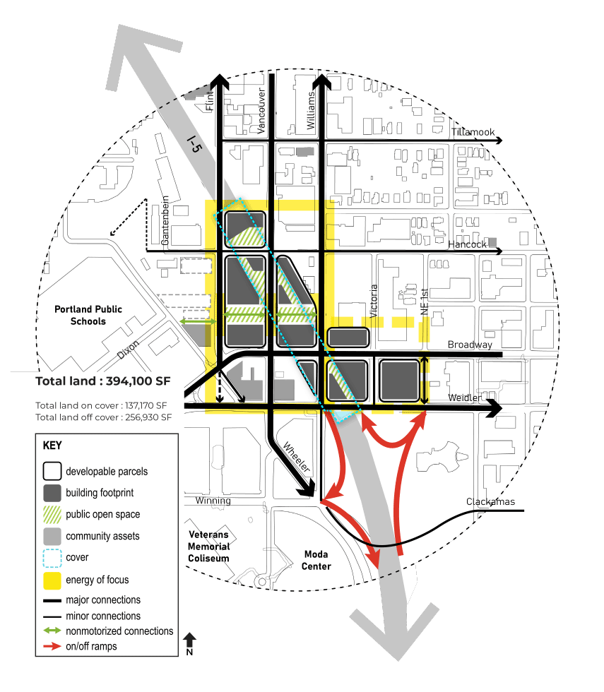
Area of potential impacts shown.
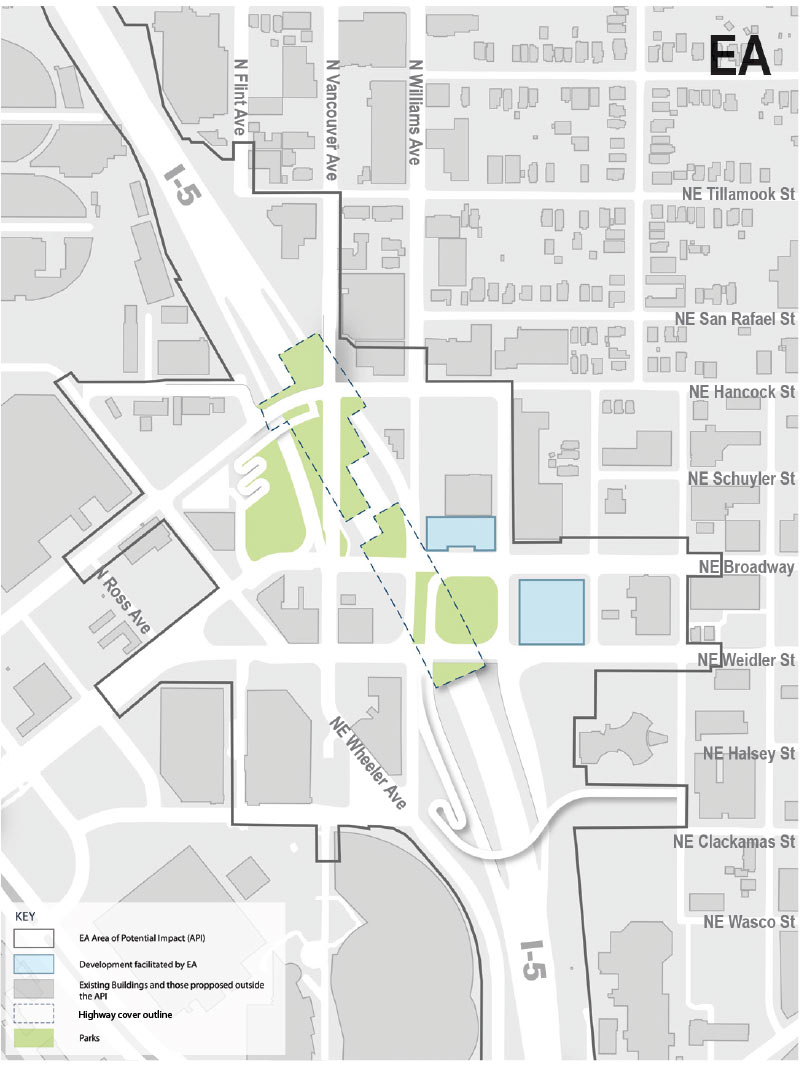
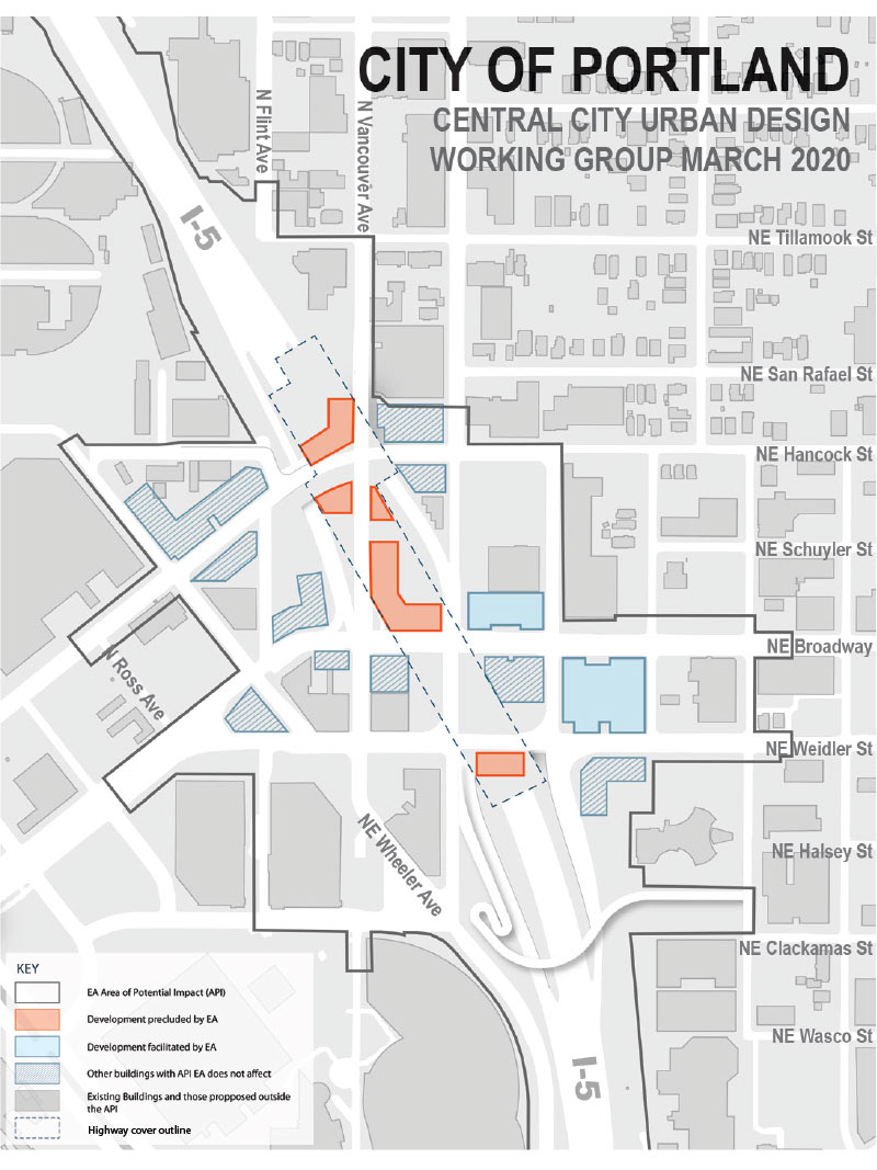
Environmental Assessment
Green space and development within the area of potential impact, analyzed in the Environmental Assessment (EA).
City of Portland
City of Portland preliminary concept for open space and development within the area of potential impact.
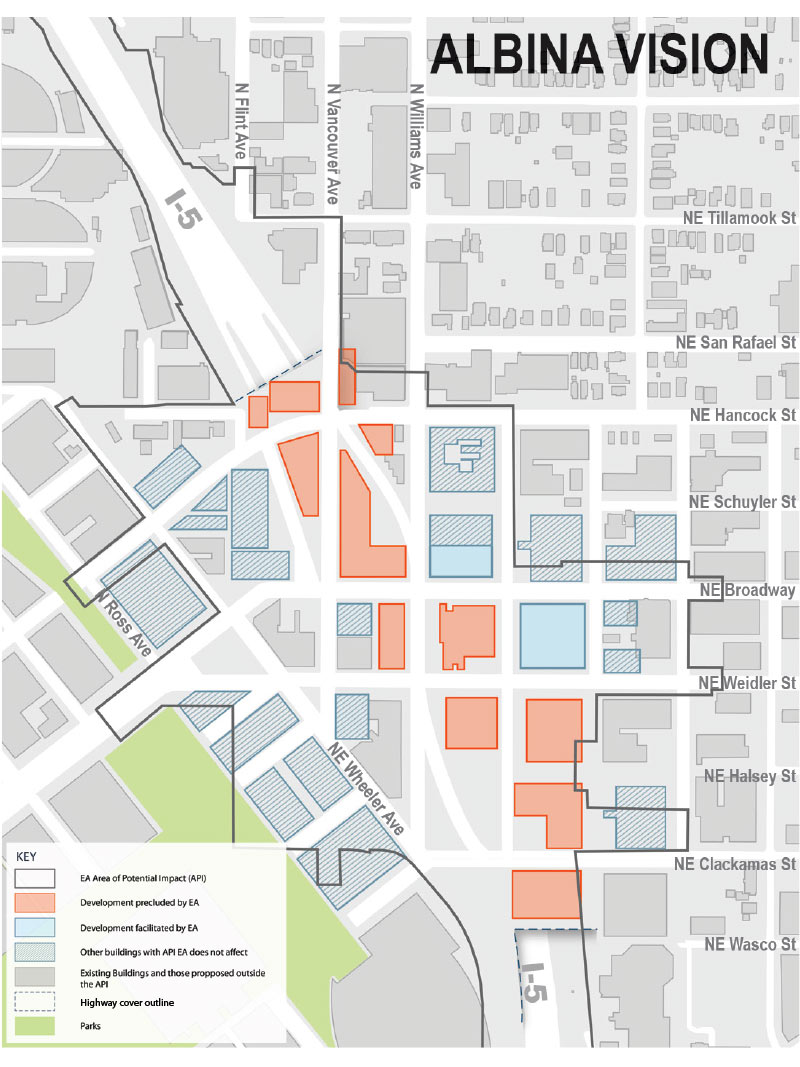
Albina Vision
Albina Vision proposal for open space and development within the area of potential impact.


Project Goals
The Independent Cover Assessment team is charged with engaging the community in a visioning and evaluation process to help identify alternative designs for the covers that will more closely align with the Black Historic Albina community’s vision and goals for the area. The goal is to create 2-3 alternative highway cover development scenarios that allow development opportunities that provide restorative justice for the past harm done to the Black Historic Albina community in the 1960s when the I-5 freeway was originally built. The I-5 freeway construction cut a pathway through the middle of the existing Black community, displacing hundreds of Black homes and businesses, and fragmenting the community.
Work Session 2
In Work Session 2, the Independent Cover Assessment team presented a range of concept scenarios that showed how the cover design configurations could facilitate the delivery of the priorities identified by the Historic Albina community participants and other stakeholders in Work Session 1. There were key questions and a discussion about each of these concept scenarios to help the Independent Cover Assessment team refine its analyses in preparation for Work Session 3. This helps the Independent Cover Assessment Team understand the benefits and trade-offs in development of scenarios that are most important to the Black Historic Albina community in the restoration of this neighborhood.
The goal and theme for Work Session 2 are:
Goal: Listen/Assess
Theme: “How can the neighborhood‘s density, mix of uses, multi-modal transportation system and freeway facilities be reorganized in the area on and around the highway covers to provide the greatest restorative benefits and improvements for the Black Historic Albina community and other stakeholders?”
(Click images to enlarge. Images courtesy of ZGF Architects.)

Existing conditions with the area of potential impact shown.

Green space and development within the area of potential impact, analyzed in the Environmental Assessment (EA).
City of Portland preliminary concept for open space and development within the area of potential impact.

Albina Vision proposal for open space and development within the area of potential impact.
Image gallery contents:
Community Wealth
Community Health
Community Cohesion


Overview
Early in the process, it was recognized that a revitalized neighborhood, would be one of the most effective ways to achieve restorative justice as described in the I-5 Rose Quarter Improvement Project Values and Outcomes.
Based on the Record Review, Executive Steering Committee’s adopted Values and Outcomes, and Work Session 1 community priorities, there is alignment in achieving a compact, service-rich, mixed-use neighborhood, with a strong community identity that showcases economic diversity and mobility, and serves as a model of how to address climate change in the built environment.
All Work Session 1 participants were asked to provide feedback on questions about which type of neighborhood programs and facilities they thought were most important to support Community Wealth, Community Health and Community Cohesion for the Black Historic Albina community and restorative justice. This feedback provides information to help the Executive Steering Committee consider which alternative cover scenario best meets community needs.
Top Programming Priorities Identified in Work Session 1
The following types of spaces, places, and outcomes were identified by Work Session 1 stakeholders as the top programming priorities and/or governance actions would be most desirable to implement for a restored neighborhood in the Lower Albina/Rose Quarter area:
Community Wealth
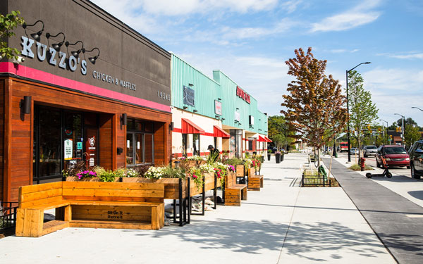
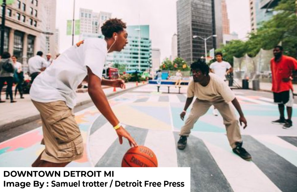
Community-owned small business with widened sidewalks, Avenue of Fashion, Detroit, MI. (Image courtesy of ZGF Architects.)
- Establish a Black community development corporation, along with a Black-controlled land trust that holds developable land in trust and can work with other partners to develop it for community benefit and maintain affordability.
- Create affordable rental and ownership business spaces of all types and sizes for Black businesses with small business support services and access to capital.
- Develop a Black food sovereignty center/market that provides job training, fresh produce for local businesses and residents, and business development support for supplying large nearby institutions, such as Legacy Emanuel Hospital, Oregon Convention Center, are hotels.
- Create permanently affordable rental and ownership housing that is mixed-use, multi-generational, built to high sustainability standards, has childcare nearby, and includes different types of living spaces such as live/work for artists and makers.
- Establish a job training and development center for vocational, technical, STEAM (Science, Technical, Engineering, Arts and Mathematics) and clean energy jobs.
- Create quality, culturally appropriate, affordable childcare and childhood development center for working parents.
(Includes Governance action priorities)
Community Health

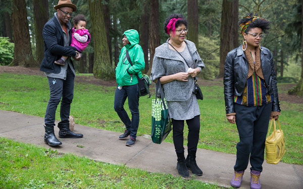
Access to green and natural environments provide physical and mental health benefits. Mount Tabor Park, Portland, OR.(Image courtesy of Intisar Abioto.)
- Develop a cultural health and wellness center with programming that addresses mental, physical and, spiritual health and provides recreation and health classes, access to healthy food, and pop-up wellness clinics.
- Provide a large, accessible outdoor community gathering space for multi-generational celebrations, festivals and events, and space that includes active recreation areas.
Community Cohesion

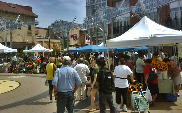
Columbia Heights Plaza in Washington DC Civic is planned and programed to celebrate and serve the historic neighborhood’s Black Community. (Image courtesy of ZGF Architects.)
- Develop a Black cultural center that showcases the history of Black Portland and creates experiences and education around Black food, Black art, and Black music.
- Develop public realm aesthetics and art installations that reflect Black culture, art, and experience.
The Independent Cover Assessment team’s evaluation of the Environmental Assessment highway cover design and alternative highway cover concepts focus on where there are opportunities to reduce the freeway interchange impacts on the neighborhood, restore the street grid, and move highway ramps to create larger, more flexible, and more valuable development parcels. The concept scenarios also consider where these new development parcels can be located to create a more cohesive neighborhood and best support the community uses identified as priorities in Work Session 1 by participants.
Review the information for each concept scenario and give us feedback that will help us understand and balance which design elements you value the most.
Image gallery contents:
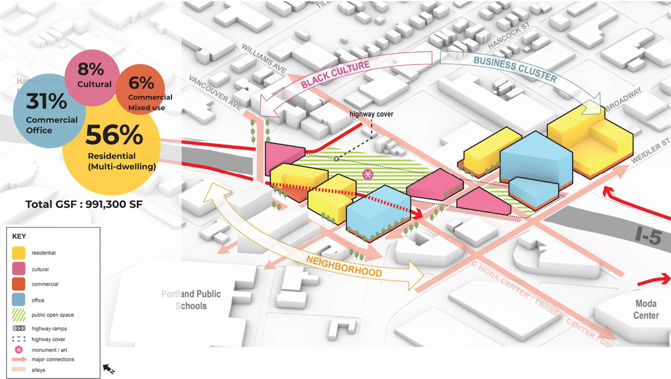
Cover Simulation
A 3d aerial image of the project area including building massing with programs in the Environmental Assessment (EA).
Plan View
A plan image of the project area including development area, green space with circulation in the Environmental Assessment (EA).


Click images to enlarge.
Development Assessment Framework Overview
| Benefits | Challenges | Feasibility | Community Wealth | Community Health | Community Cohesion | Mobility |
|---|---|---|---|---|---|---|
| ○ | ○ | ? | ○ | ○ | ◑ | ◑ |
Learn more about these ratings
Benefits
- Provides two locations for development on high-visibility streets.
- Improves pedestrian and bike connectivity on the north (via connecting Hancock) and south (via the Clackamas ped/bike bridge) edges of the project area.
Challenges
- Creates a relatively low amount of land available for community control/use.
- Park expected to be affected by air pollution, which limits its usefulness.
- Focuses traffic on a few streets, making them larger, with more traffic, less opportunity for street parking, and larger and more complicated intersections for bikes, pedestrians, and vehicles.
Regulatory/Political Feasibility ?
Unknown: The project is required to comply with a number of City of Portland plans and policies through the City’s Design Review process, (for the Dixon Hancock Connection, development planning, coordination with AVT & their development partner, Edlen & Co., and civic open space design) which are unlikely to be approved without additional coordination and consensus-building.
Image gallery contents:
Cover Simulation
A 3d aerial image of the project area including building massing with programs in concept 1, Flint/Broadway Boulevards.
Plan View
A plan image of the project area including development area, public open space with circulation in concept 1, Flint/Broadway Boulevards.


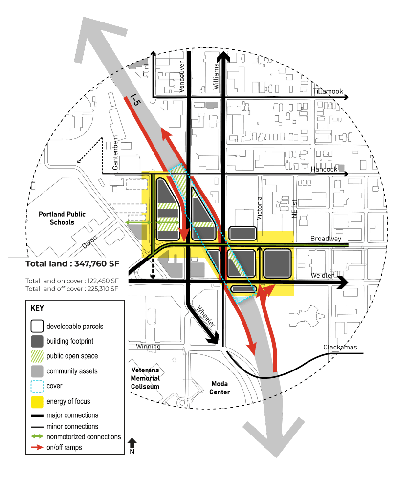
Click images to enlarge.
Development Assessment Framework Overview
| Benefits | Challenges | Feasibility | Community Wealth | Community Health | Community Cohesion | Mobility |
|---|---|---|---|---|---|---|
| ◑ | ○ | ? | ◑ | ○ | ◑ | ◑ |
Learn more about these ratings
Benefits
- Creates a moderate amount of land available for community control/use.
- Prioritizes creating active streets along Broadway and Flint.
Challenges
- Several building sites are adjacent to I-5 or a highway ramp and are expected to be affected by traffic noise and air pollution.
- Counterflow section between Williams-Vancouver and Broadway-Weidler is not intuitive for pedestrians, bicyclists, or motorists, especially for first-time users.
Regulatory/Political Feasibility ?
Unknown: The project is required to comply with a number of City of Portland plans and policies through the City’s Design Review process, (for permitting bike and pedestrian access to Dixon via Flint and Hancock, development planning, coordination with AVT & their development partner, Edlen & Co., and civic open space design) which are unlikely to be approved without additional coordination and consensus-building.
Questions
Image gallery contents:
Cover Simulation
A 3d aerial image of the project area including building massing with programs in concept 2, Vancouver as Mainstreet.
Plan View
A plan image of the project area including development area, public open space with circulation in concept 2, Vancouver as Mainstreet.


Click images to enlarge.
Development Assessment Framework Overview
| Benefits | Challenges | Feasibility | Community Wealth | Community Health | Community Cohesion | Mobility |
|---|---|---|---|---|---|---|
| ◑ | ○ | ? | ◑ | ◑ | ◑ | ◑ |
Learn more about these ratings
Benefits
- Creates a moderate amount of land available for community control/use.
- Prioritizes creating active streets along Broadway and Vancouver with a strong pedestrian connection to the Moda Center, Transit Center, and Veterans Memorial Coliseum.
- Small, thin buildings on Broadway and Weidler are expected to be inexpensive to build and could provide small, affordable business space.
Challenges
- Several building sites are adjacent to I-5 or a highway ramp and are expected to be affected by traffic noise and air pollution.
- The northbound on-ramp location prevents sidewalk construction on the west side of Williams between Broadway and Hancock.
Regulatory/Political Feasibility ?
Unknown: The project is required to comply with a number of City of Portland plans and policies through the City’s Design Review process, (for permitting bike and pedestrian access to Dixon via Flint and Hancock, proposed buildings, coordination with AVT & their development partner, Edlen & Co., and permitting for moving the southbound off-ramp onto Flint, for example), which are unlikely to be approved without additional coordination and consensus-building.
Questions
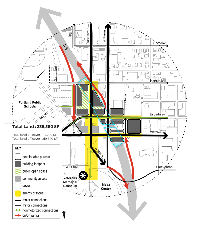
Image gallery contents:
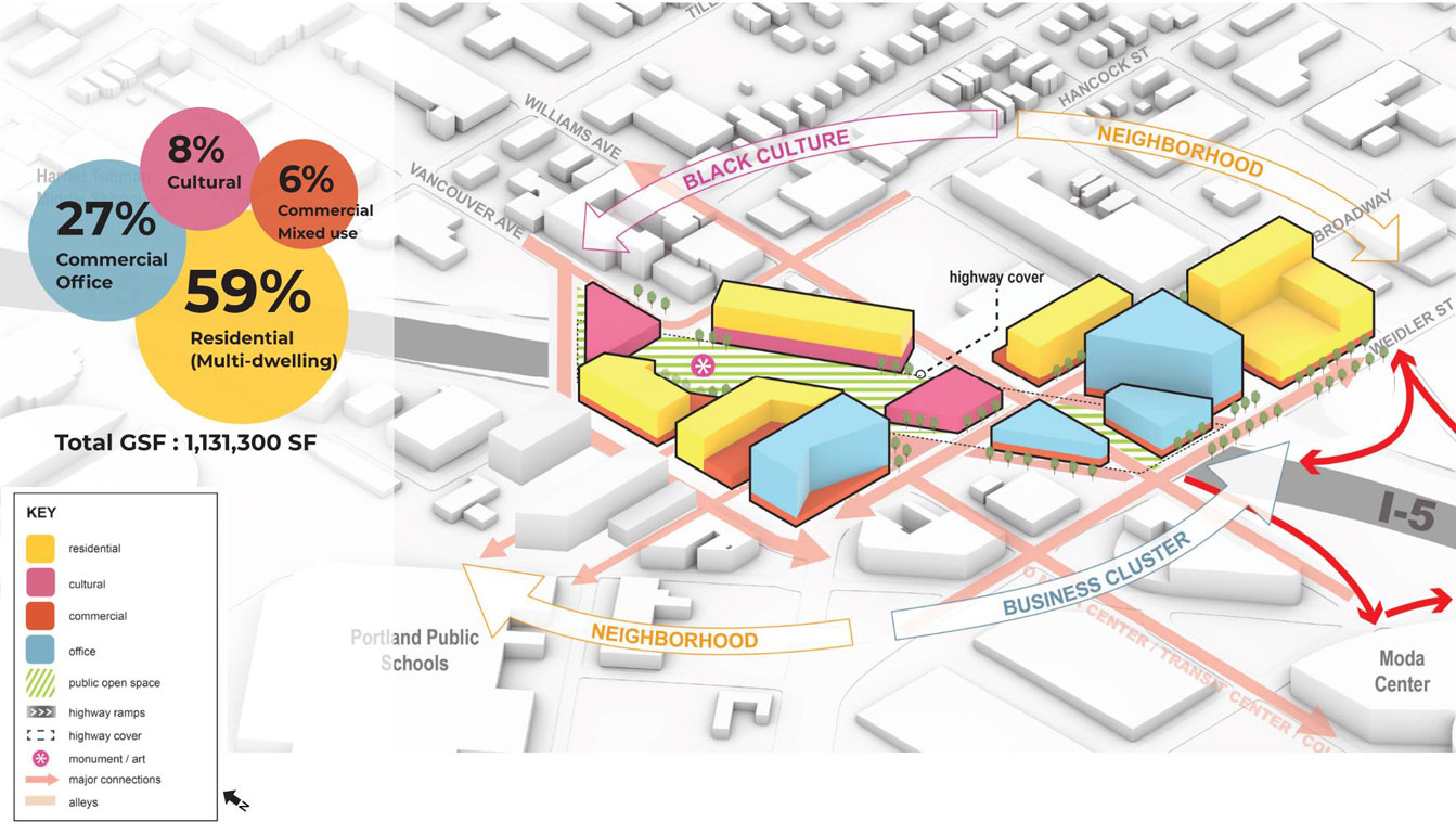
Cover Simulation
A 3d aerial image of the project area including building massing with programs in concept 3, Flint as Mainstreet.
Plan View
A plan image of the project area including development area, public open space with circulation in concept 3, Flint as Mainstreet.


Click images to enlarge.
Development Assessment Framework Overview
| Benefits | Challenges | Feasibility | Community Wealth | Community Health | Community Cohesion | Mobility |
|---|---|---|---|---|---|---|
| ◑ | ◑ | ? | ◑ | ◑ | ◑ | ◑ |
Learn more about these ratings
Benefits
- Creates a moderate amount of land available for community control/use and a civic space.
- Prioritizes creating active streets along Broadway and Flint.
Challenges
- Several building sites as well as the civic space are adjacent to I-5 or a highway ramp and are expected to be affected by traffic noise and air pollution.
- Hancock is disconnected across the cover for this scenario and does not allow pedestrians and bicyclists to bypass the high-stress Broadway - Weidler - Vancouver - Williams “box.”
Regulatory/Political Feasibility ?
Unknown: The project is required to comply with a number of City of Portland plans and policies through the City’s Design Review process, (for permitting bike and pedestrian access to Dixon via Flint and Hancock, permitting Vancouver to Flint realignment, development plans, permitting for access to properties west of Williams on Hancock, coordination with AVT & their development partner, Edlen & Co., and require coordination with Leftbank and TriMet at Wheeler and Flint for example), which are unlikely to be approved without additional coordination and consensus-building.
Questions
Image gallery contents:
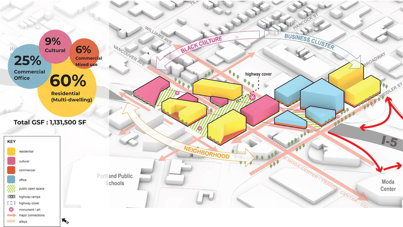
Cover Simulation
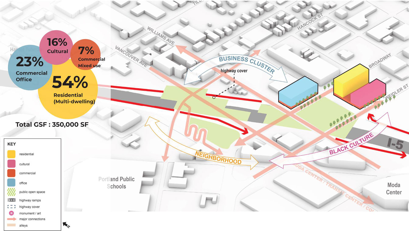
A 3d aerial image of the project area including building massing with programs in concept 4, Cultural Center on the Cover.
Plan View
A plan image of the project area including development area, public open space with circulation in concept 4, Cultural Center on the Cover.


Click images to enlarge.
Development Assessment Framework Overview
| Benefits | Challenges | Feasibility | Community Wealth | Community Health | Community Cohesion | Mobility |
|---|---|---|---|---|---|---|
| ● | ◑ | ? | ● | ● | ● | ● |
Learn more about these ratings
Benefits
- Creates a relatively high amount of land available for community control/use and a large civic space to support community events and recreation.
- Prioritizes creating active streets throughout the cover area, improving the pedestrian environment, and supporting potential future businesses.
- Relocating highway ramps to the south expected to reduce exposure of cover to noise and pollution.
Challenges
- Less buildable area than shown in concept scenario 5.
- Ramp relocation impacts
Regulatory/Political Feasibility ?
Unknown: The project is required to comply with a number of City of Portland plans and policies through the City’s Design Review process, (for permitting bike and pedestrian access to Dixon and Hancock, permitting for traffic from Vancouver to Flint, development plans, alterations to Crowne Plaza Hotel property, access and egress to events at the Moda Center, coordination with AVT & their development partner, Edlen & Co., and require coordination with Leftbank and TriMet at Wheeler and Flint for example), which are unlikely to be approved without additional coordination and consensus-building.
Questions
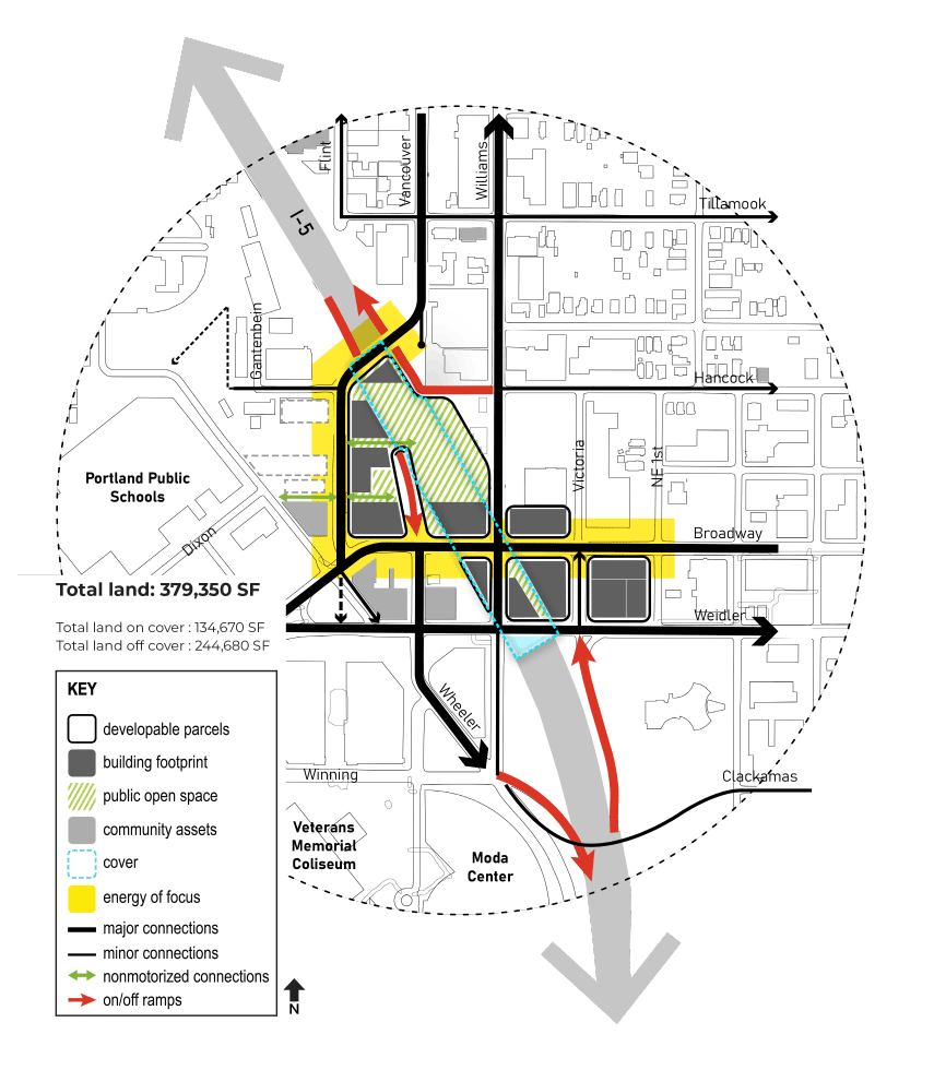
Image gallery contents:
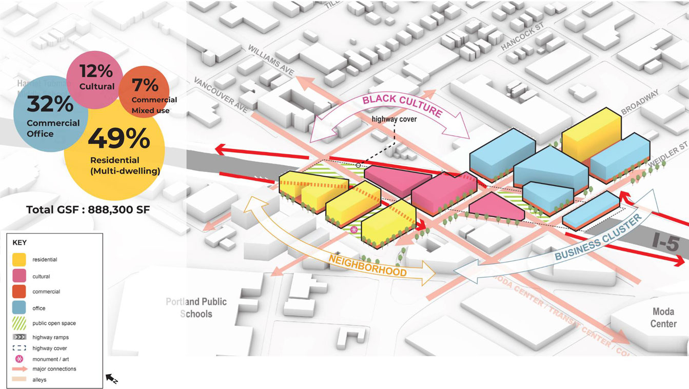
Cover Simulation
A 3d aerial image of the project area including building massing with programs in concept 5, Restore the Grid.
Plan View
A plan image of the project area including development area, public open space with circulation in concept 5, Restore the Grid.


Click images to enlarge.
Development Assessment Framework Overview
| Benefits | Challenges | Feasibility | Community Wealth | Community Health | Community Cohesion | Mobility |
|---|---|---|---|---|---|---|
| ● | ◑ | ? | ● | ● | ● | ● |
Learn more about these ratings
Benefits
- Creates a relatively high amount of land available for community control/use and a civic space.
- Prioritizes creating active streets throughout the cover area, improving the pedestrian environment, and supporting potential future businesses.
- Relocating highway ramps to the south makes a continuous cover expected to reduce exposure to noise and pollution.
Challenges
- Smaller civic space relative to other scenarios limits its capacity to support all types and sizes of community events and recreation.
Regulatory/Political Feasibility ?
Unknown: The project is required to comply with a number of City of Portland plans and policies through the City’s Design Review process, (for permitting bike and pedestrian access to Dixon and Hancock, permitting for traffic from Vancouver to Flint, development plans, alterations to Crowne Plaza Hotel property, access and egress to events at the Moda Center, coordination with AVT and their development partner, Edlen & Co., and require coordination with Leftbank and TriMet at Wheeler and Flint for example), which are unlikely to be approved without additional coordination and consensus-building.
Questions
Development Assessment Framework Overview (Summary)
| Scenario | Benefits | Challenges | Feasibility | Community Wealth | Community Health | Community Cohesion | Mobility |
|---|---|---|---|---|---|---|---|
Environmental Assessment Base Case (for comparison) | ○ | ○ | ? | ○ | ○ | ◑ | ◑ |
Concept 1 Flint/Broadway Boulevards | ◑ | ○ | ? | ◑ | ○ | ◑ | ◑ |
Concept 2 Vancouver as Mainstreet | ◑ | ○ | ? | ◑ | ◑ | ◑ | ◑ |
Concept 3 Flint as Mainstreet | ◑ | ◑ | ? | ◑ | ◑ | ◑ | ◑ |
Concept 4 Cultural Center on the Cover | ● | ◑ | ? | ● | ● | ● | ● |
Concept 5 Restore the Grid | ● | ◑ | ? | ● | ● | ● | ● |
Learn more about these ratings
Questions
Rank the five concept scenarios according to how well you think they meet community needs and serve the community priorities identified in Work Session 1.
- Concept 1 – Flint / Broadway Boulevards Not ranked.
- Concept 2 – Vancouver as Mainstreet Not ranked.
- Concept 3 – Flint as Mainstreet Not ranked.
- Concept 4 – Center on the Cover Not ranked.
- Concept 5 – Restore the Grid Not ranked.
When reviewing the differences between the cover concept scenarios, which elements do you think are most important to help provide restorative justice to the Black Historic Albina community? Which of the following features were most important in ranking your top choice(s) in the previous section?
Drag the handles to allocate points between scenario features. Give more points to the features that you think are more important. For the purposes of this exercise, you are limited to 66 points with a maximum of 15 points per feature.
| Maximizes developable land on and around the covers available for community use | 0 |
| Maximizes the intensity of development on the covers | 0 |
| Creates opportunities for active street level activity on and around covers | 0 |
| Reduces air and noise impacts for neighborhood on and around covers | 0 |
| Simplifies circulation and safety for multimodal travel in the area | 0 |
| Provides mixed use and community-oriented services in the area | 0 |
| Improves traffic flow through the area | 0 |
| Restores neighborhood street character north of Broadway | 0 |
| Creates viable, useable open space on and/or near the covers | 0 |
| Restores neighborhood street grid north of Broadway | 0 |
| Minimizes project delays and costs by implementing similar cover design | 0 |
Total Spent: 0/66
Image gallery contents:
Value Spectrum
Value Spectrum

Looking Ahead
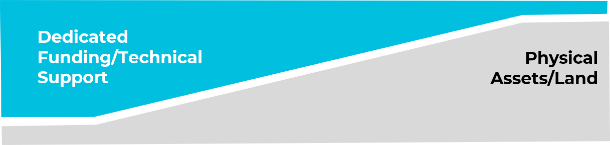
Providing viable developable land for community use and programming was one of the top community priorities identified in Work Session 1. The Independent Cover Assessment concept scenarios that maximize this goal could be used as the measuring stick to establish the “value” of the community benefits that are provided to the Black Historic Albina community to meet the Black Community’s restorative justice goal. Under this approach, how the total “value” of community benefits is delivered by the project to the Black Historic Albina community would vary depending on the which highway cover scenario is selected.
This page shows an illustration of how the five Independent Cover Assessment concept scenarios might vary in delivering total community benefits (“value”) using this approach. Scenarios falling on the left side of the community benefits value spectrum would deliver community benefits through a combination of more dedicated flexible funding and technical support for community redevelopment initiatives and less physical assets/land. Scenarios falling on the right side of the spectrum would deliver community benefits through a combination of more physical assets/land and less dedicated flexible funding and technical support for community redevelopment initiatives.
Maximum Community Benefit

Concept 1 Maximizes value through dedicated funding and technical support for community redevelopment | Concept 2, 3, 4 Balance between Concepts 1 and 5 | Concept 5 Maximizes value through physical assets and land for community development |
We are interested in your opinion about how community benefits (value) should be conveyed to the Black Historic Albina Community.
Questions
In your opinion, which of the following benefits would provide the greatest value and create the best potential for delivering restorative justice to the Black Historic Albina community?
(Check up to 4.)Image gallery contents:
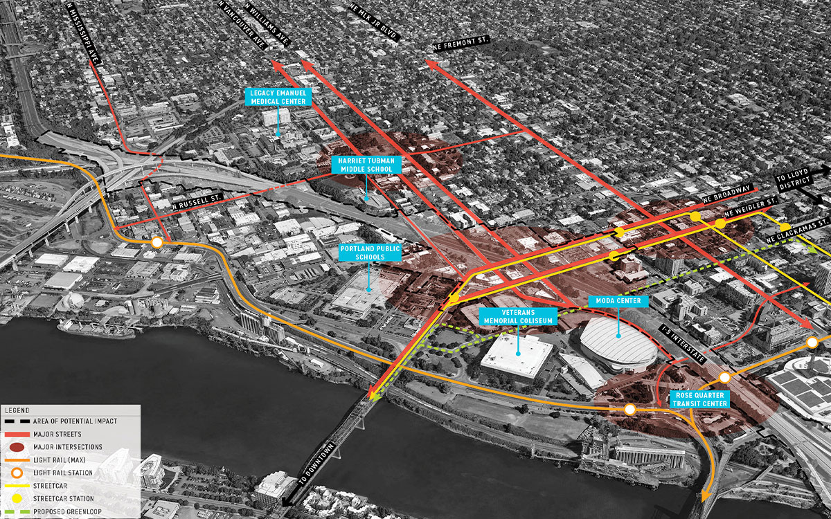
Diagram of project area
The highway covers can improve existing corridors and make new connections that revitalize this area of the City.
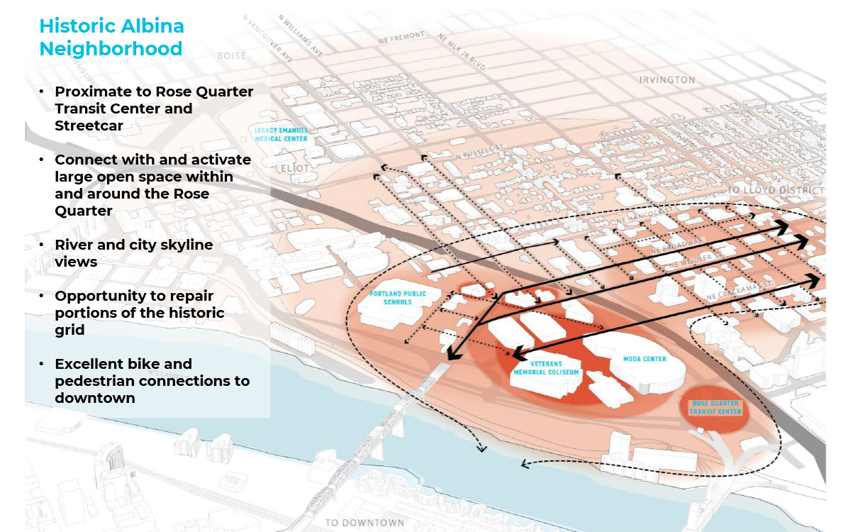
Historic Albina Neighborhood
Opportunity areas connected by highway covers if located the near Rose Quarter.
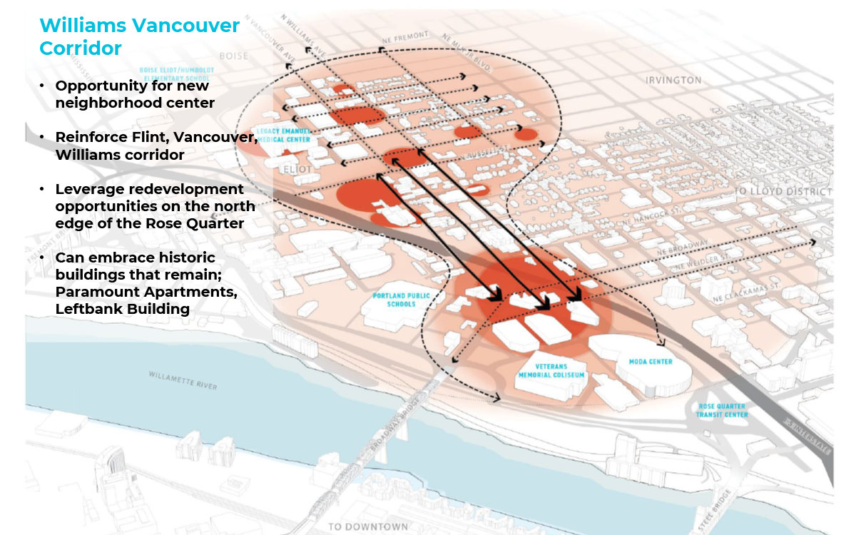
Williams/Vancouver Corridor
Opportunity areas along Williams and Vancouver that could be connected by highway covers.
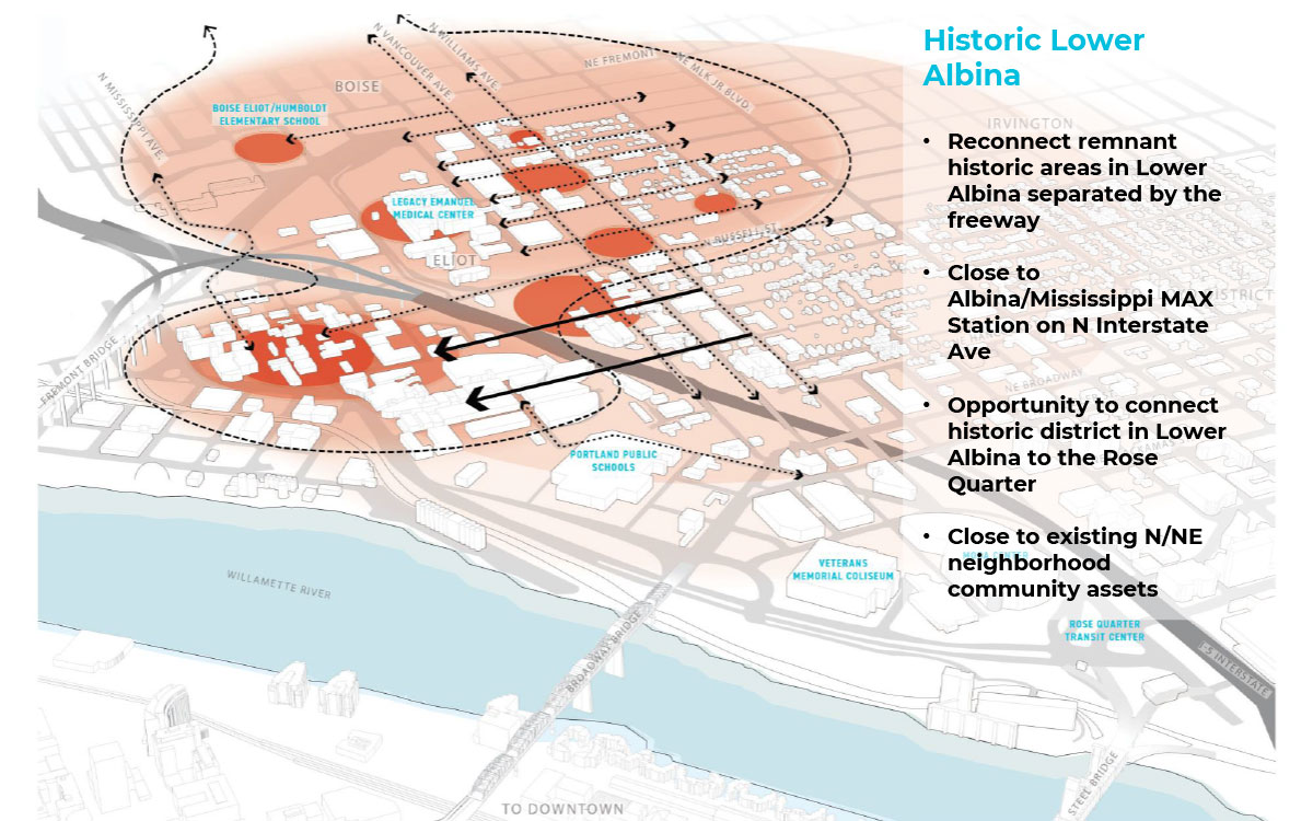
Historic Lower Albina
Opportunity areas improved or connected by highway covers near Tubman Middle School.


Looking Ahead
For the final Work Session in June, the Independent Cover Assessment team will take up to three alternative cover design concepts and further analyze and refine them based on the feedback received from participants in Work Session 2. One of these concepts must be consistent with the Environmental Assessment (EA) Base Case design parameters. Concept 1 meets this requirement, so it will be included as one of the final scenarios further studied for Work Session 3.
In addition to Concept 1, and the top scenario that emerges from Work Session 2, the Independent Cover Assessment team will be working with the Executive Steering Committee to determine whether a third scenario gets carried forward. A summary of the feedback gathered in Work Session 2 will be used to inform this decision.
Building on the feedback received in Work Sessions 1 and 2, the team will develop and provide more detailed technical cost and constructability analysis on these 2-3 options and develop governance and financing strategies for how each scenario can be implemented. The goal/theme for Work Session 3 is to review, analyze and refine these 2-3 design scenarios to form a basis for the Executive Steering Committee to make a recommendation to the Oregon Transporation Commission in July 2021.
Learn More...
Final Questions
Tell us About You
The following questions are optional and help the ICA public involvement team to continually aim for balanced and diverse involvement in our public processes.
For ADA (Americans with Disabilities Act) or Civil Rights Title VI accommodations, translation/ interpretation services, or more information call 503-731-4128, TTY 800-735- 2900 or Oregon Relay Service 7-1-1.
Si desea obtener información sobre este proyecto traducida al español, sírvase llamar al 503-731-4128.
Nếu quý vị muốn thông tin về dự án này được dịch sang tiếng Việt, xin gọi 503-731-4128.
Если вы хотите чтобы информация об этом проекте была переведена на русский язык, пожалуйста, звоните по телефону 503-731-4128.
如果您想瞭解這個項目,我們有提供繁體中文翻譯,請致電:503-731-4128
