Information and survey questions about the Recommended Option are organized around the Plan’s four key planning principles, found on the pages below. The City of Tigard wants you to weigh in on the draft plan. Thank you for participating!
For many years Tigard leaders have imagined the Tigard Triangle as a place where Tigard’s future growth could occur with a mix of complementary uses like housing, employment and shopping; an area safe and convenient for pedestrians and bicycles allowing people to not rely on their cars for some trips. Despite these hopes, development has been traditional big box retail and office buildings with few service businesses or open spaces for those in the Triangle community. There are limited places to walk or bike and the easiest way to travel within the Triangle is still by car. This planning process aims to reimagine the Triangle’s future.
About the Recommended Option
The Recommended Option considers ways to improve the experience and options of people shopping, working, living and recreating in the Triangle. This vision also includes safe and convenient transportation connections, particularly for pedestrians and bicyclists. Some of the Recommended Option’s big ideas include:
- Organizing the Triangle into several different land uses at a variety of densities to accommodate potential development now and into the future.
- Creating new gathering places and amenities for residents, shoppers and employees in the Triangle.
- Building on natural attributes to improve the way the area looks and provide ways for people to connect with the natural environment.
- Considering street design that support the different travel needs so all modes of travel can move through the Triangle effectively and safely.
- Requiring several changes to the existing Comprehensive Plan, Development Code, and Transportation System Plan.


At this event station: The Recommended Option seeks to meet the goals of the Getting Around principle (listed above) in several ways. Big ideas are reviewed in the video, listed below and shown on the Open House Displays (all shown on this page) Once you have reviewed this information, please tell us how well you think the Recommended Option accomplishes the Getting Around principle by answering the questions at the bottom of the page.
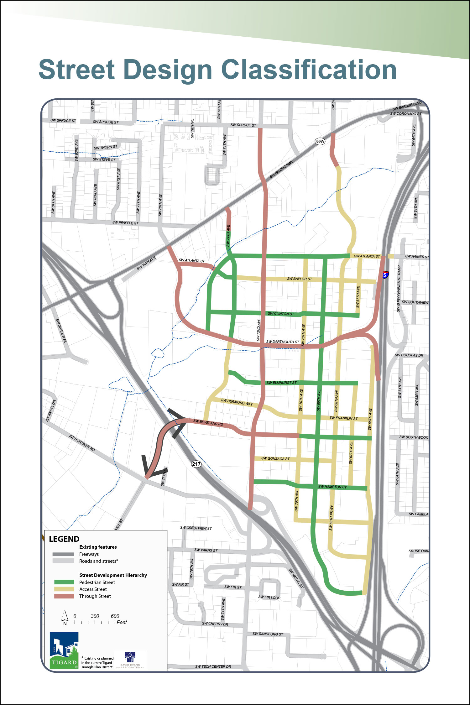
Street Design Classification
The Plan identifies different priorities for different streets within the Triangle:
- Pedestrian Streets: Requirements for new buildings and sidewalks make the area safer and more pleasant for people walking or riding their bikes.
- Access Streets: Provide access to parking, business needs, but also include requirements for buildings like pedestrian streets. Parking areas would be shielded from pedestrians by landscaping.
- Through Streets: Are busier streets for through movement and access, primarily for cars. They are wider streets with traffic devices to support all modes of travel.
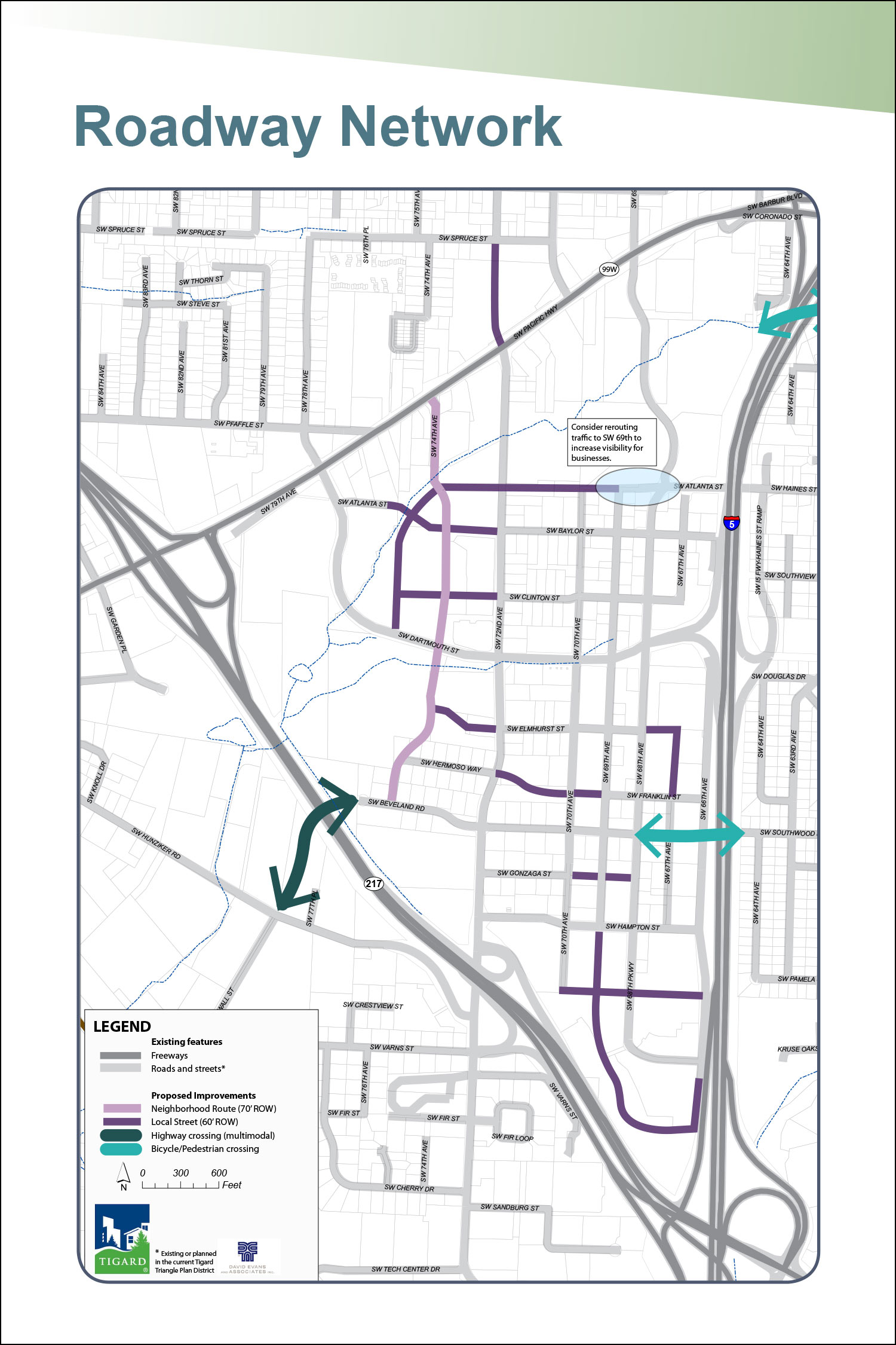
Road Connections & Highway Crossings
All modes of travel benefit from additional road connections and highway crossings.
- Pedestrian District on SW 69th Street.
- Complete the street grid.
- More designated bike lanes and roads.
- Improved pedestrian crossings and connections to transit options.
- At least 11-foot sidewalks, landscaping, and on-street parking.
- Designated bike lanes are provided along higher-traffic streets, which also connect to the larger system outside of the Triangle.
- Car travel is dispersed to relieve pressure on key intersections.
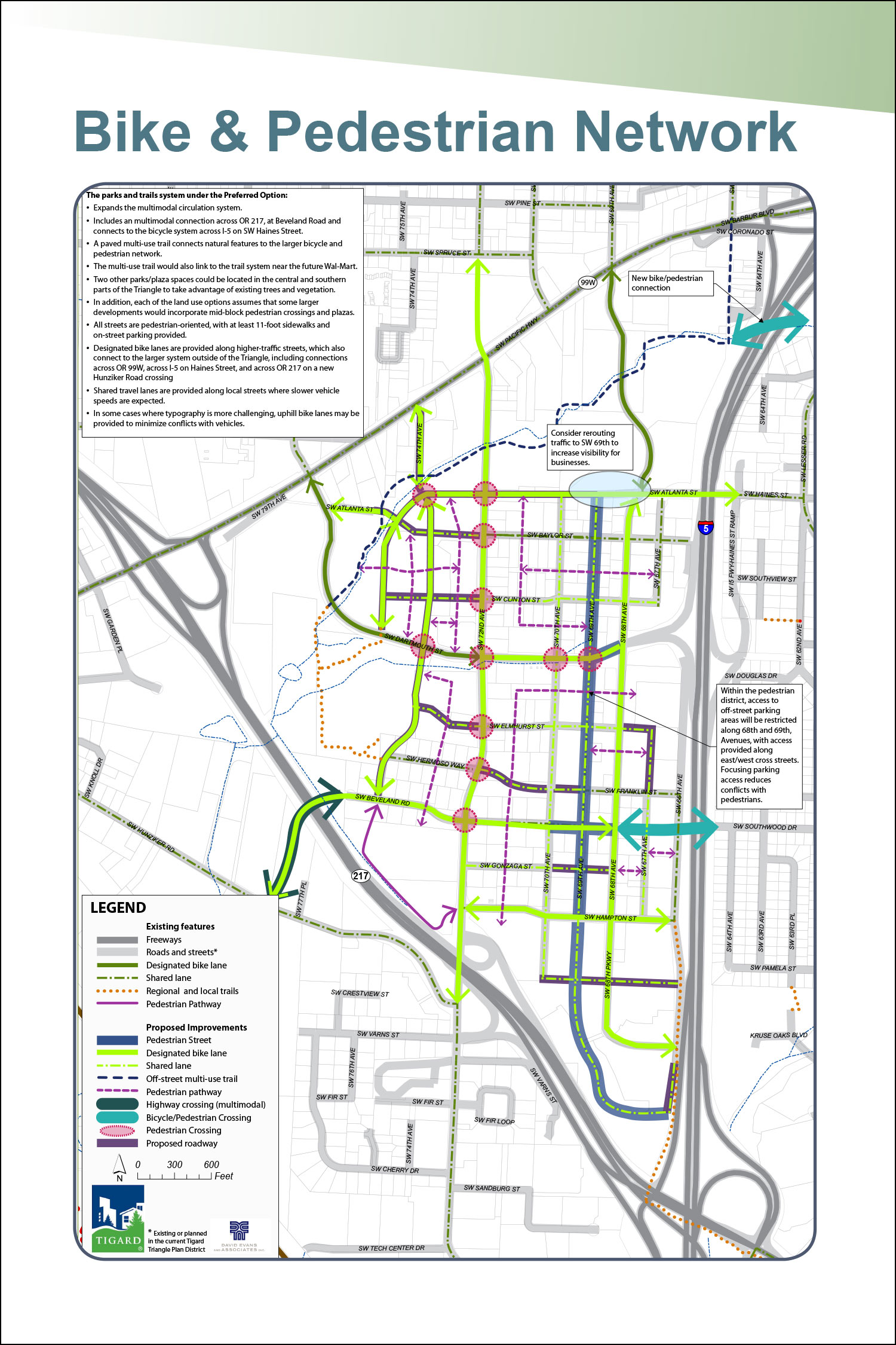
Bike & Pedestrian Network
The parks and trails system under the Recommended Option:
- Expands the multimodal circulation system.
- Includes a multimodal connection across OR 217, at Beveland Road and connects to the bicycle system across I-5 on SW Haines Street.
- A paved multi-use trail connects natural features to the larger bicycle and pedestrian network.
- The multi-use trail would also link to the trail system near the future Wal-Mart.
- Two other parks/plaza spaces could be located in the central and southern parts of the Triangle to take advantage of existing trees and vegetation.
- In addition, each of the land use options assumes that some larger developments would incorporate mid-block pedestrian crossings and plazas.
- All streets are pedestrian-oriented, with at least 11-foot sidewalks and on-street parking provided.
- Designated bike lanes are provided along higher-traffi c streets, which also connect to the larger system outside of the Triangle, including connections across OR 99W, across I-5 on Haines Street, and across OR 217 on a new Hunziker Road crossing
- Shared travel lanes are provided along local streets where slower vehicle speeds are expected.
- In some cases where typography is more challenging, uphill bike lanes may be provided to minimize confl icts with vehicles.
Traffic Sensitivity Analysis
A traffic sensitivity analysis identifies changes in trips for the Recommended Option compared with the existing zoning in the Triangle. The following results are preliminary.
Increased residential and mixed-use densities proposed with the Recommended Option appear to produce fewer new trips
because:
- More small-scale retail, residential and office in the future would generate less traffic.
- Plans make it easier to walk or bike for short trips.
- Reduces reliance on single occupancy vehicles.
Related Information
- Street Functional Classification (PDF, 987KB)
- Regional Active Transportation Network (PDF, 1.9MB)
Getting Around Questions
Plan Principle: The plan provides safe and efficient travel for drivers, bikers, and walkers. It accounts for future transit that may come to the area.
1. Does the recommended option meet the following goals?
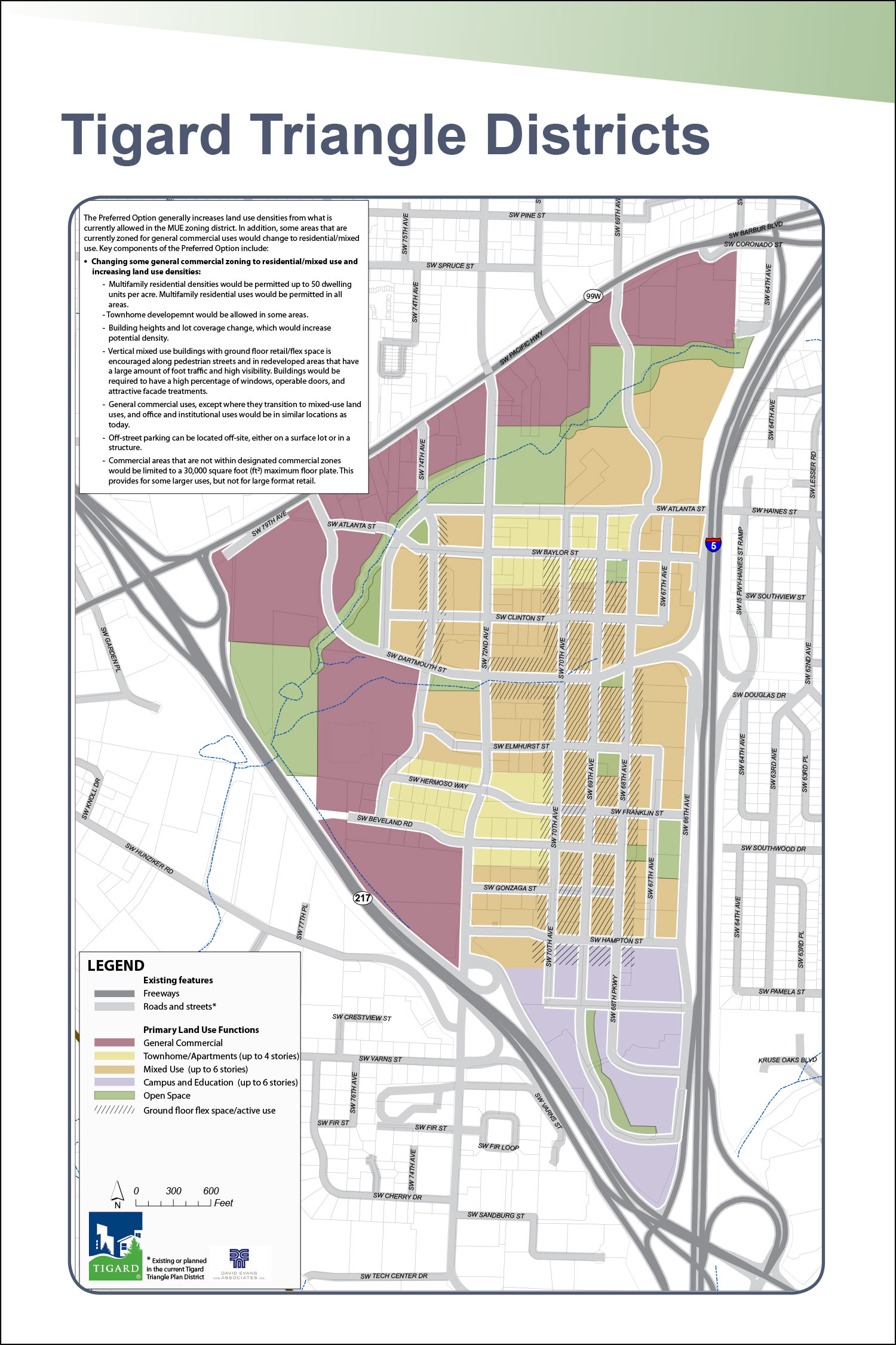
Tigard Triangle Districts

At this event station: The Recommended Option seeks to meet the goals of the Activity Centers principle (listed above) in several ways. Big ideas are reviewed in the video, listed below and shown on the Open House Displays (all shown on this page). Once you have reviewed this information, please tell us how well you think the Recommended Option accomplishes Activity Centers principle by answering the questions at the bottom of the page.
Tigard Triangle Districts
The Plan seeks to create activity centers through the development of four distinct districts in the Triangle, including:
Townhome/ Apartment
This district seeks to provide:
- Range of housing types and affordability.
- Location offers amenities like parks, trails, safe pedestrian and bicycle facilities, nearby shopping and jobs.
- Provides near-by housing for employees.
- Today’s market supports new housing in this area like townhomes or apartments.
- More people living in this district could bring additional growth to small businesses, office and housing.
Pedestrian District (Mixed-Use)
This district seeks to provide:
- Access to additional small retail businesses could offer employees places to eat, get coffee and gather.
- The plan requires pedestrian-oriented streets, which includes:
- Shorter blocks.
- Shops, business entries and windows on the street level and parking behind buildings.
- Fewer driveways interrupting the sidewalks to reduce conflicts with pedestrians.
- Buildings starting within 10 feet of the sidewalk for improved visibility from the sidewalk.
General Commercial District
This district seeks to provide:
- Minimal changes to this already established regional shopping destination.
- Provides shopping options for nearby residential and office uses.
- Employees who work in this District can live nearby.
Campus and Education
This district seeks to provide:
- Builds on existing college activity and office developments.
- Larger buildings with green spaces.
- Opportunity for consolidated parking for multiple uses.
Related Information
- Land Use and Building Heights (PDF, 1.0MB)
Activity Centers Questions
Plan Principle: The plan creates vibrant town centers by mixing shopping, dining, homes, and offices that are safe and enjoyable to walk between.
2. Does the recommended option meet the following goals?
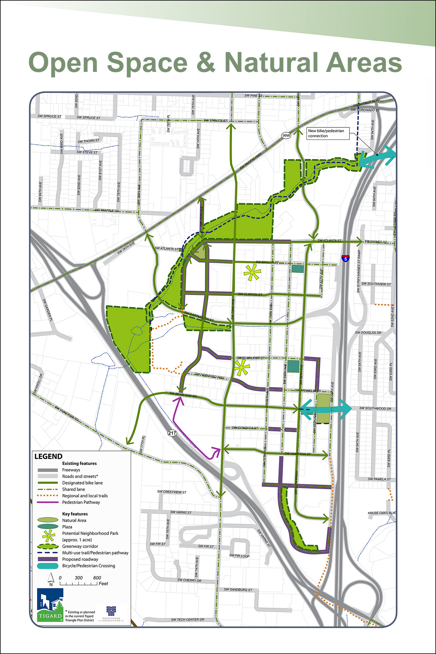
Open Space & Natural Areas

At this event station:The Recommended Option seeks to meet the goals of the Community Character principle (listed above) in several ways. Big ideas are reviewed in the video, listed below and shown on the Open House Displays (all shown on this page). Once you have reviewed this information, please tell us how well you think the Recommended Option accomplishes Community Character principle by answering the questions at the bottom of the page.
Trails/ Pathways
- Improving Red Rock Creek as both a natural and recreational amenity would make it a defining feature for the Triangle.
- Creating a pedestrian pathway system through larger blocks would make it easier to reach destinations within the Triangle.
- Improving highway crossings (one for all modes including cars over OR 217 and two crossings for only pedestrians and bicyclists across I-5).
Parks & Plazas
- Creating two neighborhood parks - could include play structures, trails, picnic tables/shelters, athletic fields, and open space.
- Including plaza spaces located in the central and southern parts of the Triangle to take advantage of existing trees and vegetation.
Community Character Questions
Plan Principle: The plan builds on existing character to make the Triangle unique, with a clear community identity. Natural areas and public spaces are incorporated.
3. Does the recommended option meet the following goals?
At this event station: The Recommended Option seeks to meet the goals of the Implementation principle (listed above) in several ways. Big ideas are listed below and shown on the Open House Displays (listed on this page). Once you have reviewed this information, please tell us how well you think the Recommended Option accomplishes Implementation principle by answering the questions at the bottom of the page.
Market and Implementation
The Recommended Option will require several changes to the existing Comprehensive Plan, Development Code, and Transportation System Plan. These changes include:
- Identifying a finance and phasing strategy to implement the plan.
- Amending/revising existing City Plans:
- Comprehensive Plan land use designations within the Triangle
- Zoning within the Triangle
- Transportation System Plan
- Amending City codes
Implementation Questions
Plan Principle: The Plan is feasible and desirable to potential residents and developers.
4. Does the recommended option meet the following goals?
5. How would you prioritize the following investments that are part of this plan?
- Parks Not ranked.
- Public plazas Not ranked.
- Natural areas Not ranked.
- Street features (benches, street lighting design, planters, etc.) Not ranked.
- Trails and off-road pathways for pedestrians and cyclists Not ranked.
- New streets that provide more connections and travel options Not ranked.
- Improvements to major roads and intersections (68th Parkway, 72ndAve., Beveland Rd., Atlanta St.) Not ranked.
- Stormwater management for the area (not site by site) Not ranked.
- Financial incentives to spur development Not ranked.
- New gateway features and signage Not ranked.
- Public art Not ranked.
- Other (explain below) Not ranked.
The Citizen Advisory Commitee and staff will review feedback recieved at through the public open house and through this online tool before finalizing a preferred plan. Once a preferred plan is finalized, the project team will develop measures for carrying out the plan. These measures will likely include zoning, code changes, and proposed finance strategies for necessary improvements. Changes to city codes, polices and zoning will be reviewed by the Tigard Planning Commission and City Council.
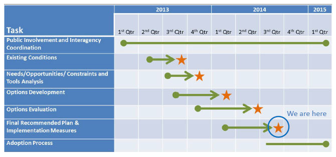
Project Schedule and Tasks
Comment Wall
From what was presented in the recommended option, which one aspect of the recommended option do you consider to be the most crucial for the successful redevelopment of the Tigard Triangle?
Read previous comments...
Susan: TRAFFIC...upgrade existing now; build new roads ASAP; keep light rail option to metro; need quick access w/o driving to entire metro area

Roger: Developing mixed use with commercial, residential, open spaces.Plan that accomodates for pedestrians, autos, and close access to light rail.