
The content of this site should take about 10 minutes to view. You may use the links below to skip to specific information, or click "Get Started" above.

= Page includes questions or opportunities for comment.


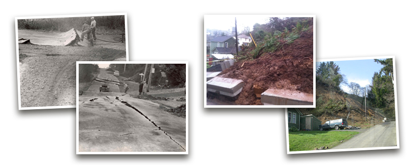
A history of landslides
Astoria has unique features. That’s part of why we love living here. Our hills are distinctive, but also put us at risk of landslides. Landslides have been part of Astoria’s geology since the City’s earliest records, and likely before. Mapping by the State of Oregon’s Department of Geology and Mineral Industries (DOGAMI) shows well over 100 landslides in Astoria — many within the last 150 years.
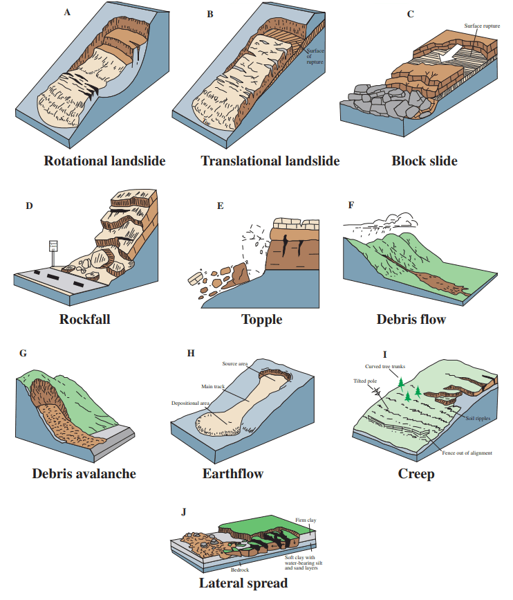
Most of the city is susceptible to landslides. About half of Astoria is prone to shallow types (9.5 feet or less) and about a third is susceptible to deep types (more than 15 feet). According to state research, the most common types in Astoria are rotational and translational (see graphic).
The City is closely monitoring risks and has taken many steps over the years to protect lives and property
These steps include using inclinometers to measure land movement, purchasing vulnerable land and restricting development, reducing water infiltration into landslide prone areas, and building retaining walls. The City also requires grading and erosion control permits in landslide prone areas.
Now, with direction from City Council, the City is developing a new ordinance that builds on previous City policies that will help homeowners and developers understand and minimize the risk of construction-triggered landslides. This ordinance uses the best available science and is informed by geological research by the State and by other cities with similar risks, including Salem, Lincoln City and Oregon City.
Landslides come in all shapes and sizes...
Questions
What kinds of landslides are we at risk for in Astoria?
Most landslides in Astoria have been rotational or translational, where an upper level of rocks and earth can separate from a more stable, underlying level. The landslide mass then can move rotationally, or in one direction. This means landslides not only pose a risk to individual properties, but also to neighboring homes and properties that lie in the slide’s direction.
Use the map on this page to determine landslide susceptibility to your property and in your neighborhood.
For more detailed information, click the link to the City of Astoria GIS page below:
Click and drag to explore the map. Zoom in to find a specific location. Turn layers on and off by clicking the  button in the upper left of the map window.
Questions
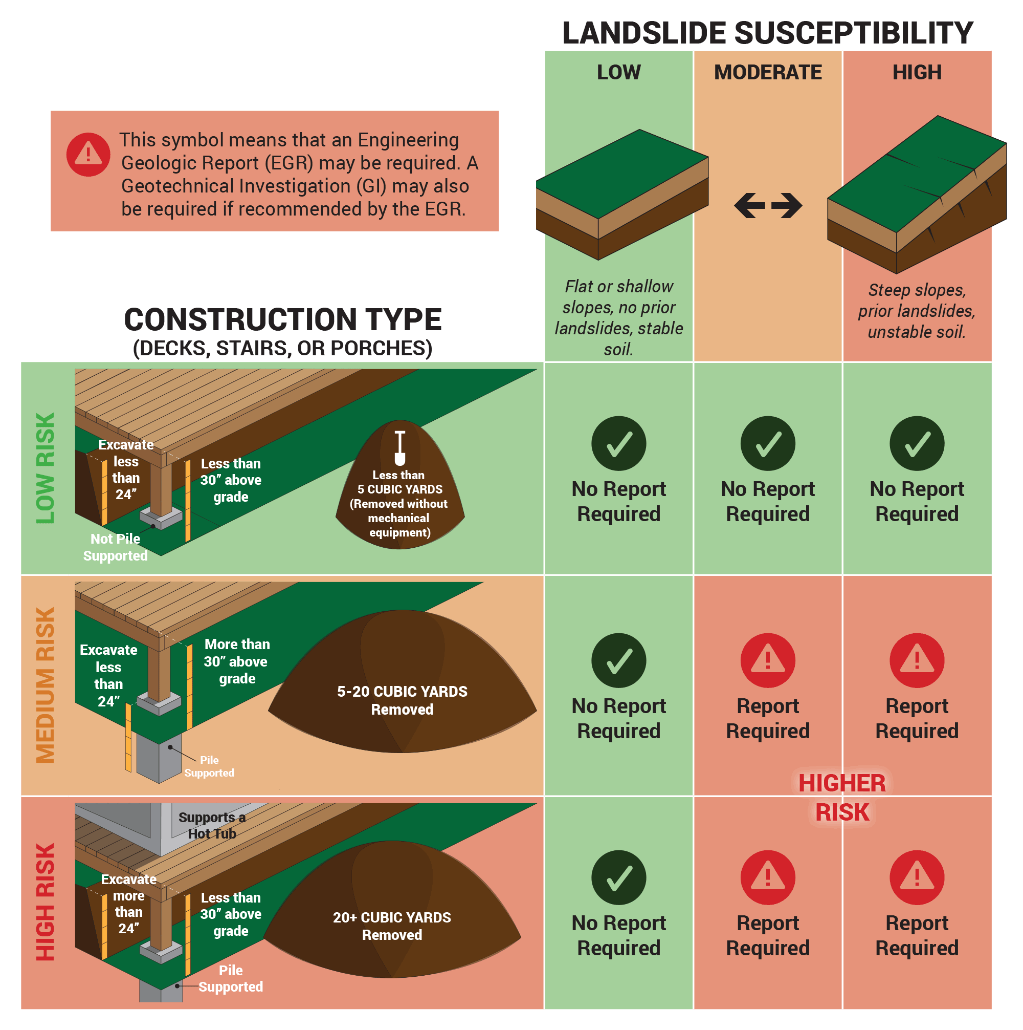
This chart shows when an engineering report may be required before construction.


Assessing Construction Risks
The City is proposing an ordinance that requires property owners to be more aware of risks before they can build some types of structures. The ordinance may require property owners to hire professional engineering geologists or geological engineers to review a project’s design and site conditions for landslide risks.
These precautions will help minimize the risk of accidental construction-related landslides to you and your neighbors.
The ordinance would consider the risk of certain construction activities, and require reports if they take place in areas with moderate or higher landslide susceptibility. Example risk levels are listed below:
- Low Risk Activity - Decks, stairs and porches less than 30” above grade that do not require excavation of more than 2’ deep, or do not require pile supported foundations, or movement of greater than 5 cubic yards of material, or use of mechanical equipment.
- Medium Risk Activity - Decks, stairs and porches greater than 30” above grade that requires pilings less than 2’ deep or excavation or movement of greater than 5 cubic yards of material but less than 20 cubic yards of material.
- High Risk Activity - Decks, stairs and porches less than 30” above grade that do require excavation of more than 2’ deep or pile supported foundations or movement of greater than 20 cubic yards of material or placement of hot tubs.
Read the full DRAFT text of the proposed ordinance (pdf, 362 KB)
(Click to enlarge.) This chart shows when a geohazard report may be required before construction.
Questions
Schedule
City Council will consider your comments and feedback at a work session in July. The City will modify the draft ordinance based on the Council’s feedback, and proceed to the Planning Commission. The City will adopt the ordinance within four to six months, depending on public health directives related to COVID-19.
Stay Involved
Provide your email below and consider sharing optional information about yourself. We’ll add you to our email list and keep you informed about other opportunities to provide input.
- For more information, contact Barbara Fryer, Community Development Department: (503) 338-5138 or bfryer@Astoria.or.us.
- Visit the City of Astoria website: www.astoria.or.us
