
Welcome to our final online open house!
Over the last year, we’ve collected a lot of great feedback from our students, faculty, staff, and PCC neighbors about the physical environment at each of our campuses. In addition to this qualitative input, we analyzed data on student enrollment, regional demographics and market trends.
Based on this information, we created draft development concepts that accommodate future college growth over the next 10 to 20 years.
For more details on the Facilities Plan and to see a full summary of community input to date, visit pcc.edu/fp2.
We need your input!
We invite you to review draft concepts for each PCC campus and let us know your thoughts. Your feedback continues to be an integral part of this process.
All comments are anonymous and will be presented in a way that does not identify individual users. It should take about 10 minutes to review and comment on one campus.
Open House Stations
View the information on this site using the buttons below or click “Get Started” above to move through the content in order.
= Page includes questions or opportunities for comment.
For technical support or assistance using this site, contact tech@jla.us.com or call 971-303-9311.
What we learned from the community
Over the 2020-2021 school year we conducted multiple rounds of outreach to collect community input on the physical spaces of the PCC campuses. During the winter over 400 community members took part in an online open house about spaces that make them feel welcome and/or safe. Additionally, in spring, approximately 200 people provided feedback while participating in virtual workshops and an online survey.
Our outreach thus far has provided insight on what is valued and appreciated on PCC campuses and what is not. Across the district, there is a shared desire for more comfortable and welcoming indoor and outdoor spaces for students to collaborate, connect, and study within a busy schedule. Campuses should be easier to navigate to remove barriers to finding resources and support. We also heard ideas about how to improve access to campus by walking, biking, transit, and driving.
What we learned from the growth study
In addition to input from the college communities, the project team analyzed data on student enrollment and demographics to forecast enrollment through 2030 for each campus. The forecast predicts an overall increase in enrollment at PCC in the next 10 years, with some campuses growing more than others. The amount of projected growth at each campus informed the draft plans and ideas for future development. We also gathered data on housing insecurity among PCC students across the district and identified opportunity sites for affordable housing partnerships at each campus.
Image gallery contents:
Existing Cascade Campus
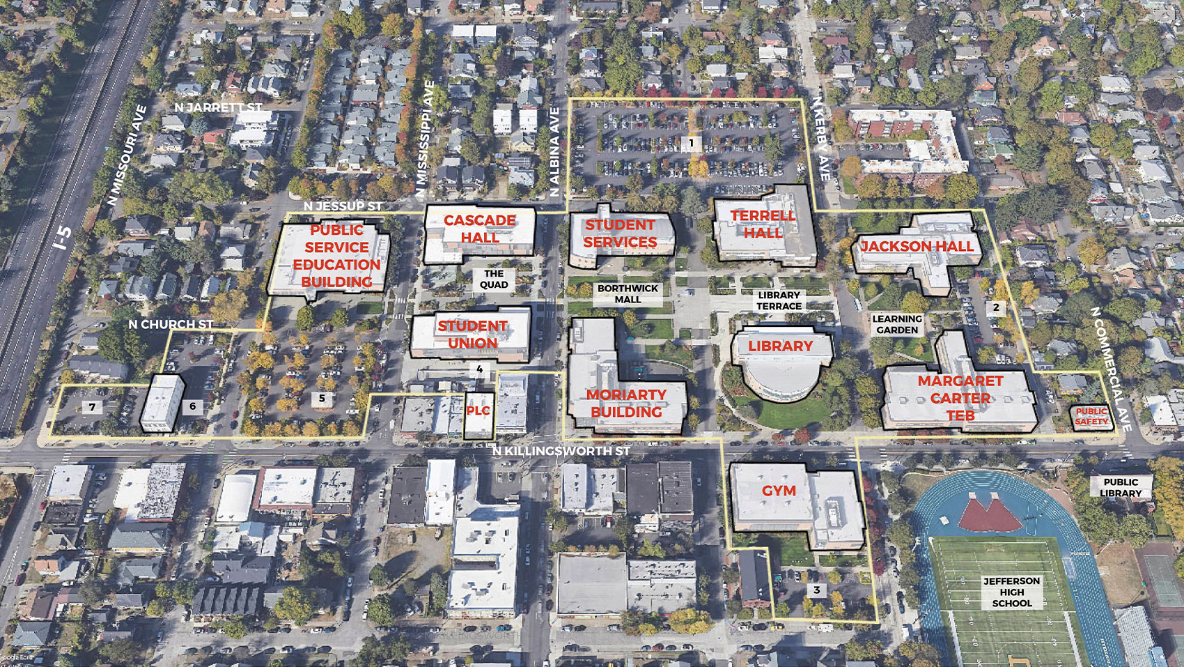
An aerial photograph view looking down at the Cascade Campus from a southern angle, showing a few blocks of the surrounding streets and neighborhoods. I-5 is visible at the left where Killingsworth Street crosses the freeway. A yellow line indicates the boundary of the existing campus. The campus buildings are outlined in black and labeled in red, and campus open spaces are labeled: The Quad, Borthwick Mall, Library Terrace, and Learning Garden. Outside the campus, in the bottom right of the image, Jefferson High School and the North Portland Library are labeled.
Campus Planning Concept
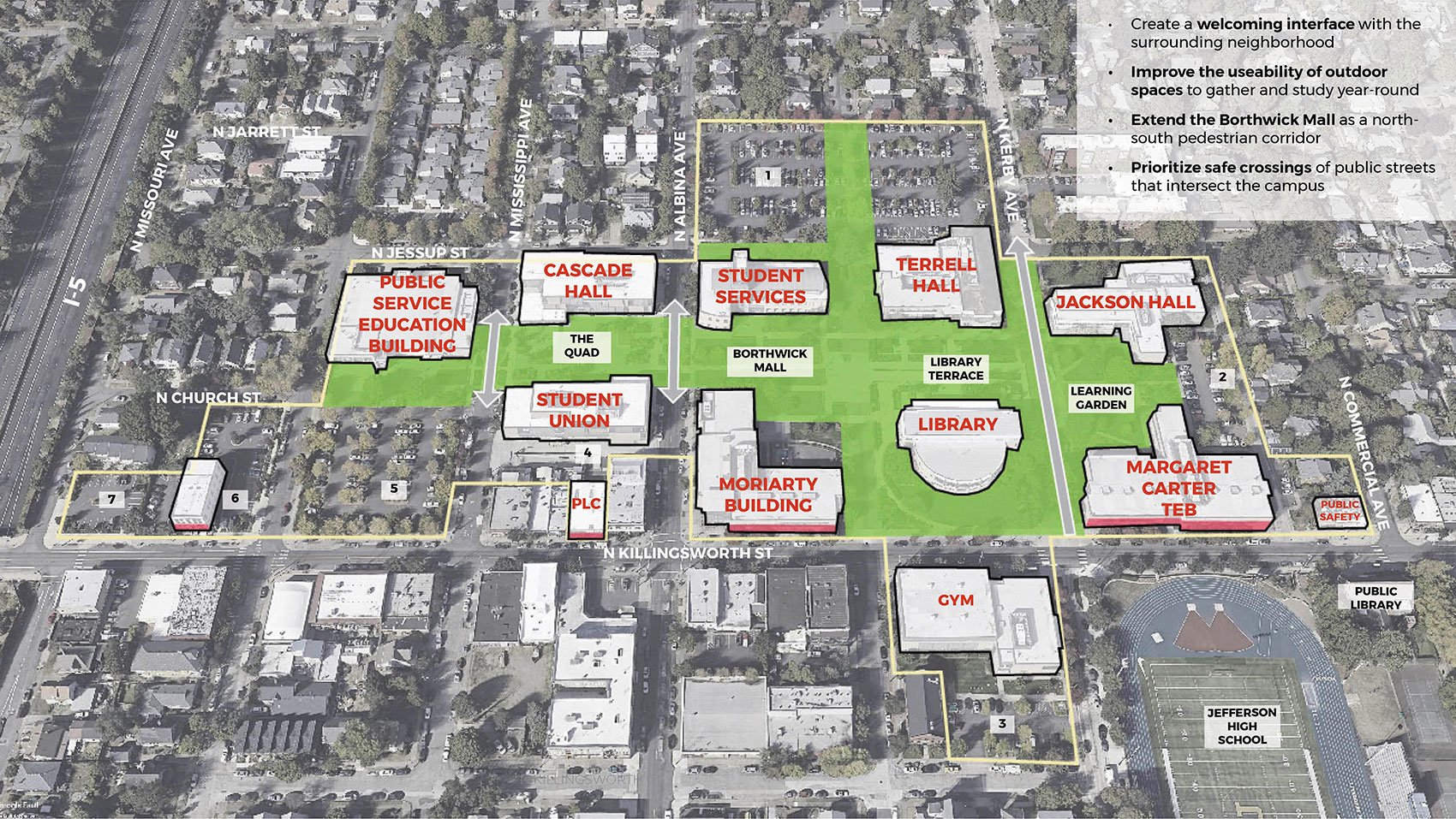
The same aerial photograph view as shown in the Existing Campus image, but slightly faded to black and white. A bright green color fills and connects the important outdoor areas of the campus, including the area in front of the Public Service Education Building, the Quad between Cascade Hall and the Student Union, the Borthwick Mall area between the Student Services Building and the Moriarty Building, the areas surrounding the library, and the area between Jackson Hall and the Margaret Carter Technology Education Building. The green color extends north between the Student Services Building and Terrell Hall through the northern parking lot to indicate a pedestrian connection to the neighborhood. A small green area extends from Terrell Hall to Albina Avenue along Jessup Street where it enters the campus. Grey arrows cross the green color where streets intersect the campus, including Mississippi, Albina, and Kerby Avenue. Along Killingsworth Street, the campus buildings have pink edges.


We heard what is cherished on campus and important to preserve, such as:
- Its integration with the community through cultural events and openness to the neighborhood
- Green spaces like the Borthwick Mall and the Learning Garden
- And ease of access by transit, biking, and walking
Based on college and community input and projected campus growth, future development at Cascade Campus should focus on:
- Creating a welcoming interface with the surrounding neighborhood, both with commercial and residential land uses
- Improving the useability of open spaces as places to gather and study year-round
- Extending the Borthwick Mall as a north-south pedestrian corridor
- Prioritizing safe crossings of public streets that intersect the campus
Existing Cascade Campus
Campus Planning Concept
(click images to enlarge)
Image gallery contents:
Option 1
The same aerial photograph view as shown in the Campus Planning Concept image. Three areas of the campus have an orange fill with a dashed black outline, indicating future development areas. At the top right of the image, a white box contains text reading: “Option one places a building just north of the Student Services Building and across Jessup Street, creating a new pedestrian open space.” An orange area about the same size as the existing Student Services Building is shown north of that building parallel to Jessup Street on the northern parking lot. It has a bright red dashed edge facing Jessup Street and along the north-south green area that connects to the neighborhood at the north. Its other edges are black. It is labeled “Option 1: 10-year growth and any other needs”. A second orange area is shown parallel to Kerby Avenue on the eastern edge of the northern parking lot. It is labeled, “Potential Affordable Housing”. A third orange area is shown on PCC’s parking lot seven, on the northeast corner of Killingsworth Street and Missouri Avenue. It is also labeled “Potential Affordable Housing”. It has a bright red dashed edge along Killingsworth Street. The existing Public Safety building on the northwest corner of Commercial Avenue and Killingsworth Street has light orange stripes over it, labeled, “Public Safety Building currently being assessed”. The Student Union building has an orange dot on its northeast corner on Albina Avenue labeled “Welcome Center”. A purple rectangle along the east side of Kerby Avenue between Jackson Hall and the Margaret Carter TEB is labeled “Mobility Hub”.
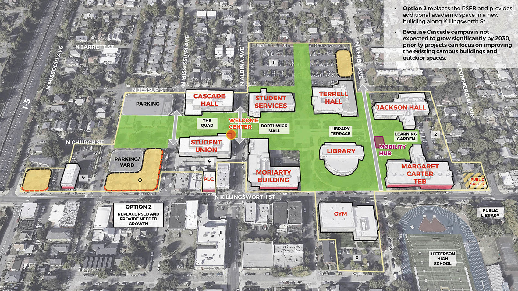
Option 2
The same aerial photograph view as shown in the Campus Planning Concept image. Three areas of the campus have an orange fill with a dashed black outline, indicating future development areas. At the top right of the image, a white box contains text reading: “Option two replaces the PSEB and provides additional academic space in a new building along Killingsworth Street. Because Cascade Campus is not expected to grow significantly by 2030, priority projects can focus on improving the existing campus buildings and outdoor spaces.” An orange area is shown in an L shape bordering Killingsworth Street between Michigan Avenue and Mississippi Avenue at the south and Mississippi Avenue across from the Moriarty Building at the east. It has bright red dashed edges along the streets, and its other edges are black. Tucked behind the L-shape is a grey area labeled “parking / yard”. The orange area is labeled “Option 2: Replace PSEB and provide needed growth.” The other parts of the drawing are the same as in Option One.
Library Terrace
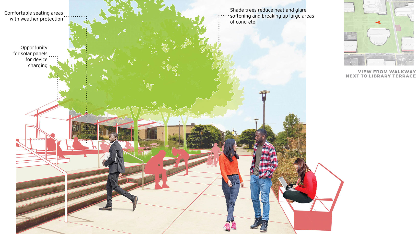
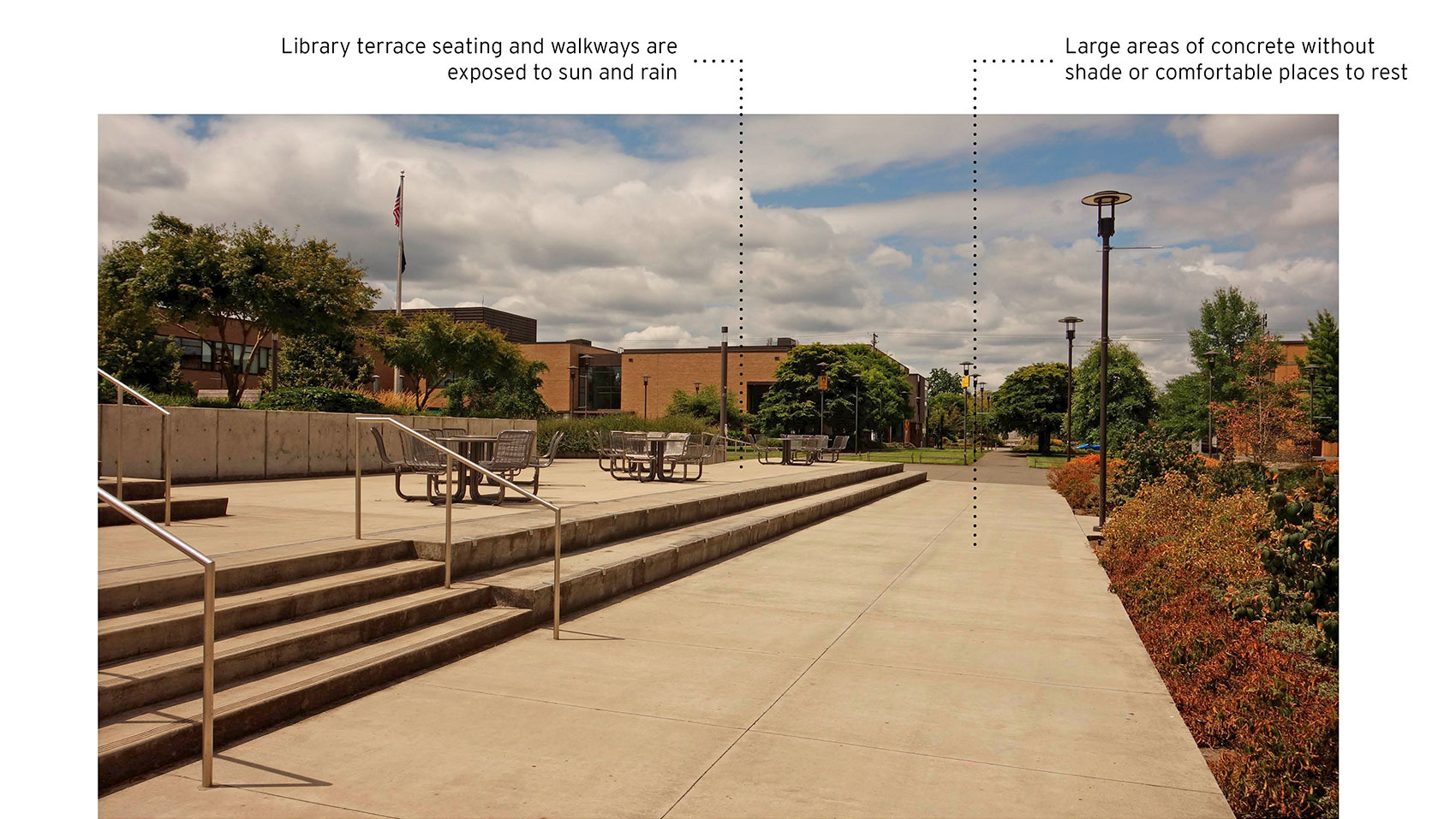
Photograph taken on a sunny day looking west toward the Borthwick Mall from the concrete pathway north of the library. The stairs up to the library are at the left. Metal seating is shown on the terrace on the left, two steps above the pathway. To the right is a landscaped area. The pathway is labeled “Large areas of concrete without shade or comfortable places to rest”. The terrace area is labeled “Library terrace seating and walkways are exposed to sun and rain”.
Conceptual Graphic
Artist’s rendering of the same view. The landscaped area at right includes a bench with a student seated using a laptop. Two students are standing in the pathway talking. A student is shown walking toward the steps to the library. On the terrace area, three trees are planted in a row at the top of the second step with planted areas around them. The trees are labeled, “Shade trees reduce heat and glare, softening and breaking up large areas of concrete”. At the back of the terrace, a long bench with a roof structure covering it is shown with silhouettes of students studying and relaxing. The long, covered bench on the terrace is labeled, “Comfortable seating areas with weather protection”. The roof structure is labeled, “Opportunity for solar panels for device charging”. A key map at the top right shows an orange arrow pointing west between the library and Terrell Hall, labeled “view from walkway next to library terrace”.


The Facilities Plan will provide multiple options for future growth to be accommodated at Cascade Campus. Because the campus does not need much additional space in the next 10 years based on forecasted enrollment data, PCC can remain flexible at this location.
Future Development Areas - Option 1
One option for future growth is just north of the Student Services Building and across Jessup St. If a new building is placed here, this area could be transformed into a pedestrian friendly, open space between those buildings.
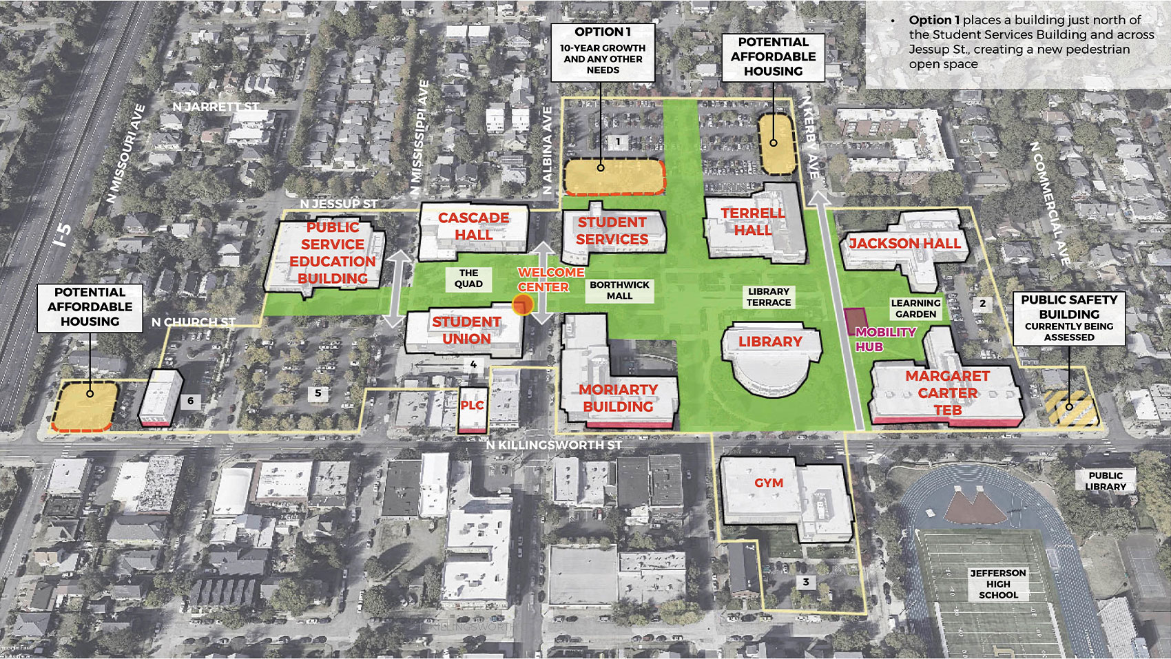
Future Development Areas - Option 2
Another option for future consideration is to replace the PSEB and provide additional academic space in a new building along Killingsworth St. This would create a more welcoming edge along the street, freeing up land to the north for parking or future development.
Other Opportunities for Improvement
While future development at this campus is more uncertain than at other locations, there is an opportunity to improve existing buildings and outdoor spaces.
- The ground floor of the Student Union building could be made into a more engaging space with student resources.
- The Learning Garden area can provide seating and gathering space that also serves the shuttle stop.
- Options for affordable housing at the far west of campus or along North Kerby Ave., north of Terrell Hall are also included.
The conceptual image envisions how outdoor spaces can be made more comfortable and usable at the Cascade Campus. Adding trees in large concrete areas will provide shade and cooling in the summer. Comfortable seating areas with weather protection could be added along existing walls. Sheltered areas could also include solar panels with plugs to charge phones and laptops.
View of Library Terrace Area Looking West
Comfortable and Usable Outdoor Spaces

(click images to enlarge)
Image gallery contents:
Existing Campus
An aerial photograph view looking down at the Rock Creek Campus from a southern angle, showing the surrounding streets and neighborhoods. Northwest 185th Avenue is visible at the left, and Northwest Springville Road is at the bottom. The campus buildings are in the center of the view, and Rock Creek is shown running along the top of the drawing. The forest is labeled “protected natural area”. The THPRD athletic facility, childcare, museum, learning garden, landscape technology area, and grazing and farm areas are labeled. A yellow line indicates the boundary of the existing campus. The campus buildings are outlined in black and labeled in red.
Concept Graphic
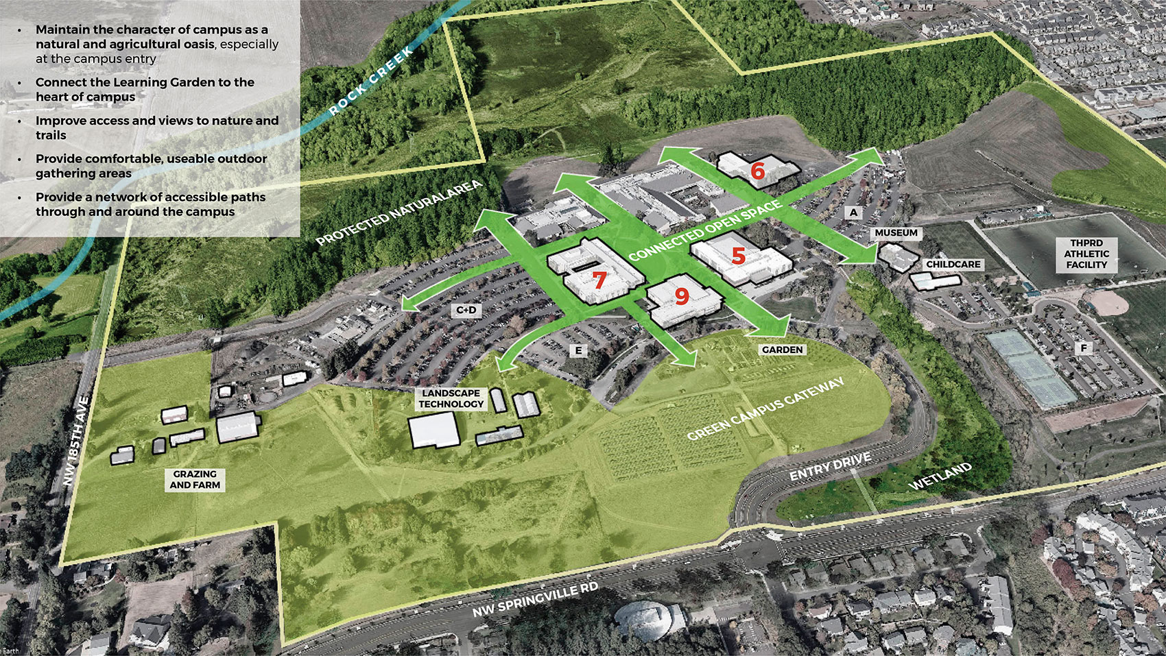
The same aerial photograph view as shown in the Existing Campus image, but slightly faded to black and white. A bright green color fills and connects the important outdoor areas in the center of campus, and extends in arrows between buildings toward the forest, fields, and learning garden. A dark green color is overlaid on the natural areas and extends along the eastern boundary of the campus, labeled “protected natural area”. A lighter green covers the fields and farm at the south and west of campus, labeled “green campus gateway”.


We heard what is cherished on campus and important to preserve, such as:
- The forested areas and wetlands
- The Learning Garden
- Art inside and outside of buildings
- Visibility into academic and career technical programs available on campus
Based on college and community input and projected campus growth, future development at Rock Creek should focus on:
- Maintaining the essential character and identity of campus as a natural and agricultural oasis, especially at the campus entry
- Improving the connection between the Learning Garden area and the heart of the campus
- Improving access and views to nature and trails
- Providing comfortable, useable outdoor gathering areas
- Providing a network of accessible paths through and around the campus
Existing Rock Creek Campus
Campus Planning Concept

(click images to enlarge)
Image gallery contents:
Future Development
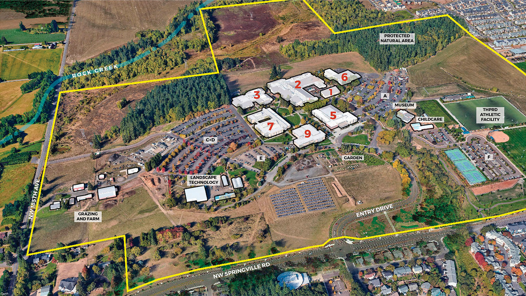
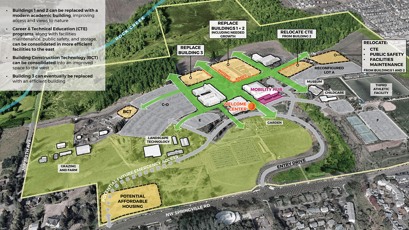
The same aerial photograph view as shown in the Campus Planning Concept image. Six areas of the campus have an orange fill with a dashed black outline, indicating future development areas. The first orange area over Buildings 1 and 2 is labeled “replace buildings one and two, including needed growth”. The second is shown over Building 3, labeled “replace Building 3”. Two orange areas along the south side of the green arrow pointing east are labeled “relocate CTE from building two” and “relocate CTE, public safety, and facilities maintenance from buildings one and two”. The development areas have bright red edges labeled “inviting edges” where they touch the important open spaces. A small orange area is shown in the existing Building Construction Technology yard. The last area is shown at the southwest corner of campus along Springville Road, labeled, “Potential Affordable Housing”. Building 9 has an orange dot on its southeast corner labeled “Welcome Center”. There is a purple rectangle along the south side of Building 5 that is labeled “Mobility Hub”. At the top left of the image, a white box contains text describing each development area.
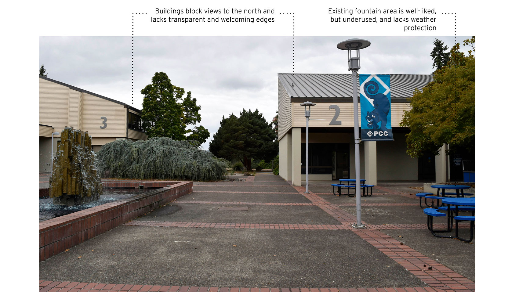
Corridor between Buildings 2 and 3
Photograph taken on a cloudy day looking north between buildings 2 and 3 toward the forest in the distance. The fountain is visible at the left, and blue metal tables at the right. The view to the forest is hidden by existing buildings and landscaping. The buildings are labeled “Buildings block views to the north and lack transparent and welcoming edges.” The seating area is labeled “existing fountain area is well-liked, but underused, and lacks weather protection”.
Future Concept Graphic
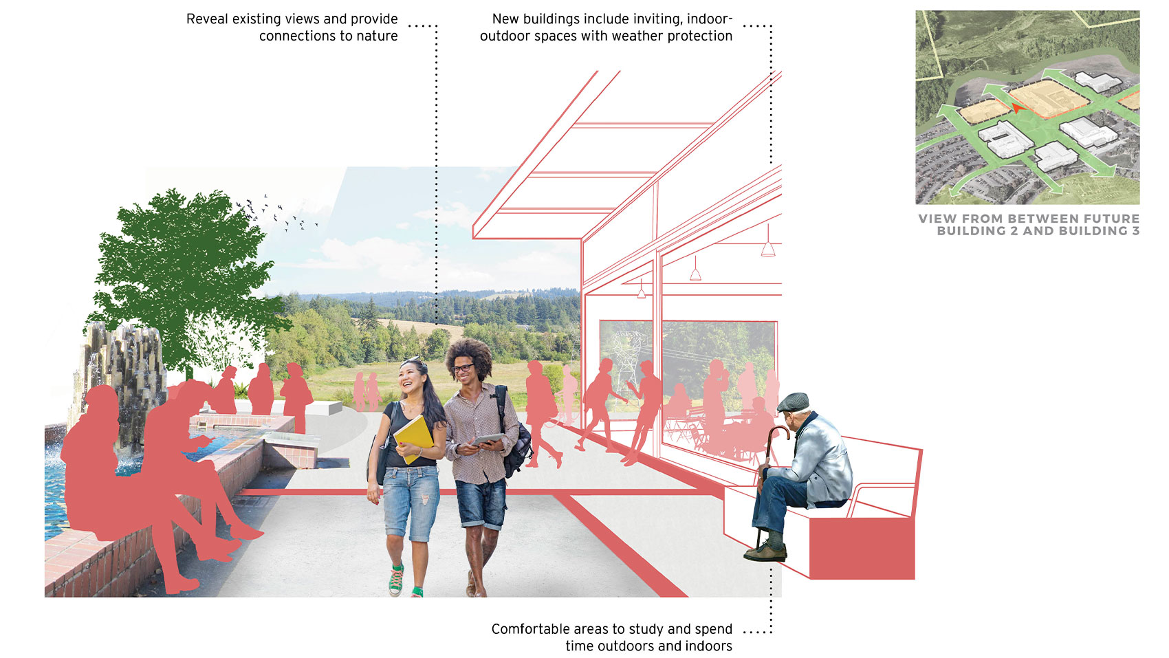
Artist’s rendering of the same view. Building 2 has been replaced with a modern building that is set back slightly and has a canopy at the first floor to provide inviting outdoor and indoor seating areas. Silhouettes of students are seen studying, walking, and interacting in and near the building. The existing view to the meadow and forest is revealed in the background, and a new seating and gathering area is shown at the edge of the meadow, connecting to a trail. A key map in the upper right shows an arrow pointing north between buildings 2 and 3, labeled “view from between future building 2 and building 3”.


The future development areas accommodate the projected space need in the next ten years and beyond.
- Buildings 1 and 2 are the oldest buildings on campus and currently contain a mix of career and technical education (or CTE) shops, storage space, and classrooms. To better serve the campus, Buildings 1 and 2 can be replaced with a modern academic building, also improving access and views to nature.
- CTE programs, along with facilities maintenance, public safety, and storage, can be consolidated in more efficient facilities to the east with strong pedestrian and vehicular connections to other campus areas.
- Building Construction Technology space currently in Building 2 can be consolidated into an improved space to the west.
- In the future, Building 3 can also be replaced with a more efficient and modern building.
Future Development Areas
Due to the building’s age and inefficiency, replacing Building 2 is considered a priority project and now being assessed for inclusion in the next capital bond measure slated for November 2022. Currently, Building 2 blocks views to the forest and turns its back to the fountain. The fountain plaza is well-liked, but under-used.
Other Opportunities for Improvement
In the conceptual drawing, you can see how improving the building, along with the site around it, will reveal lovely existing views and provide connections to the surrounding natural environment as well as offer new, comfortable gathering space for all to enjoy.
View North between Buildings 2 and 3
Open Access and Connections to Nature
(click images to enlarge)
Image gallery contents:
Existing Campus
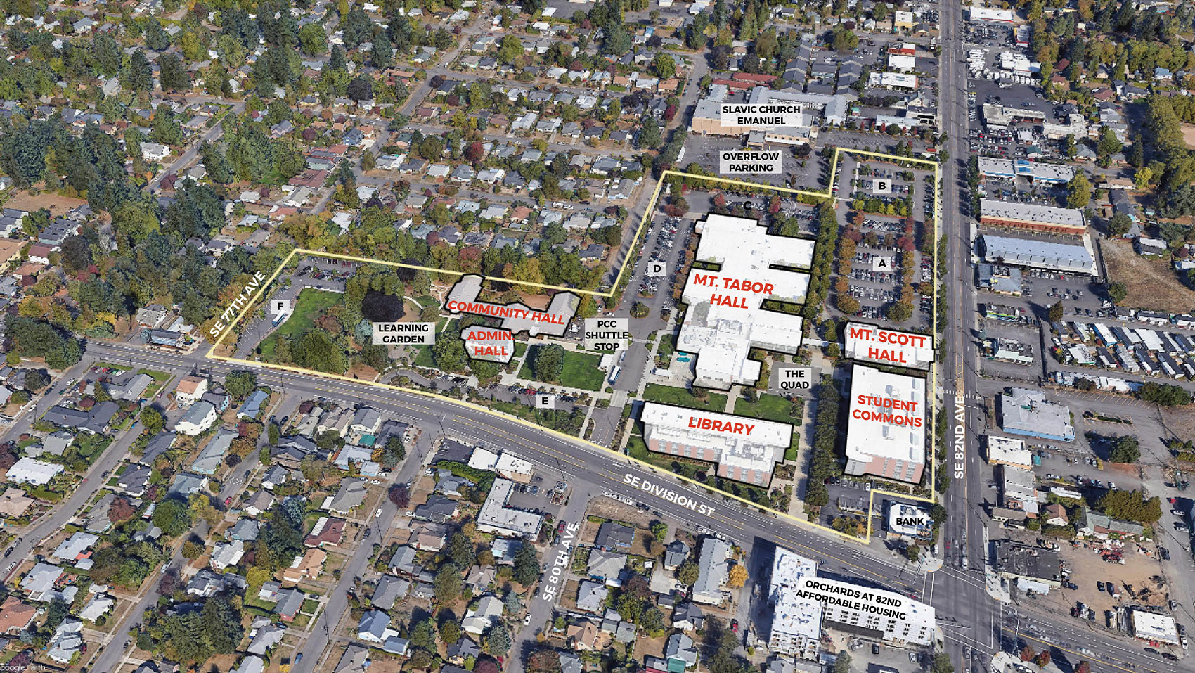
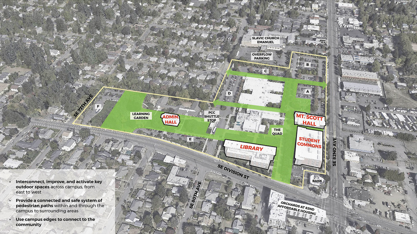
An aerial photograph view looking down at the Southeast Campus from a southern angle, showing the surrounding streets and neighborhoods. Southeast Division Street and Southeast 82nd Avenue are seen extending along the edges of the campus. The campus buildings are outlined in black and labeled in red. Campus open spaces are labeled, including the quad, the learning garden, and the PCC shuttle stop.
Concept Graphic
The same aerial photograph view as shown in the Existing Campus image, but slightly faded to black and white. A bright green color fills and connects the important outdoor areas in the center of campus, including the Quad, the lawn area and shuttle stop, and the learning garden and grove of trees. The green extends north between Mt. Scott Hall and Mt. Tabor Hall, and two new green corridors are shown running east to west through the Mt. Tabor Hall site, connecting to the neighborhood streets to the west and 82nd Avenue to the east.


We heard about what is cherished on campus and important to preserve, such as:
- Its integration within a diverse, multicultural neighborhood
- The calm, beautiful open spaces and Learning Garden in contrast with surrounding busy streets
- Spaces that support students and community, whether for studying or community gathering
Based on college and community input and projected campus growth, future development at Southeast Campus should focus on:
- Interconnecting, improving, and activating key open spaces across campus, from east to west
- Providing a connected and safe system of pedestrian paths within and through the campus to surrounding areas
- Using campus edges to connect to the community
Existing Southeast Campus
Campus Planning Concept
(click images to enlarge)
Image gallery contents:
Future Development
The same aerial photograph view as shown in the Campus Planning Concept image. Four areas of the campus have an orange fill with a dashed black outline, indicating future development areas. The first orange area is shown attached to the north side of Mt. Scott Hall, extending north along 82nd Avenue. It is labeled “new addition to Mt. Scott Hall fulfills needed growth”. The second area is labeled “Replace Mt. Tabor Hall with efficient building”. This area covers the southern portion of existing Mt. Tabor Hall, between the quad and a new east-west green corridor connecting to SE Sherman Street. An orange area is shown on the existing Community Hall site, labeled “new gym and childcare on community hall site”. The last area is shown along the western boundary of campus, labeled “potential affordable housing”. The development areas have bright red edges where they touch the important open spaces, labeled “inviting edges”. The corner of 82nd and Division Street has light orange stripes and is labeled “community corner opportunities being studied”. New Mt. Tabor Hall has an orange dot on its southwest corner near the shuttle stop labeled “Welcome Center”. There is a purple rectangle around the shuttle stop labeled “Mobility Hub”. At the bottom left of the image, a white box contains text describing each development area.
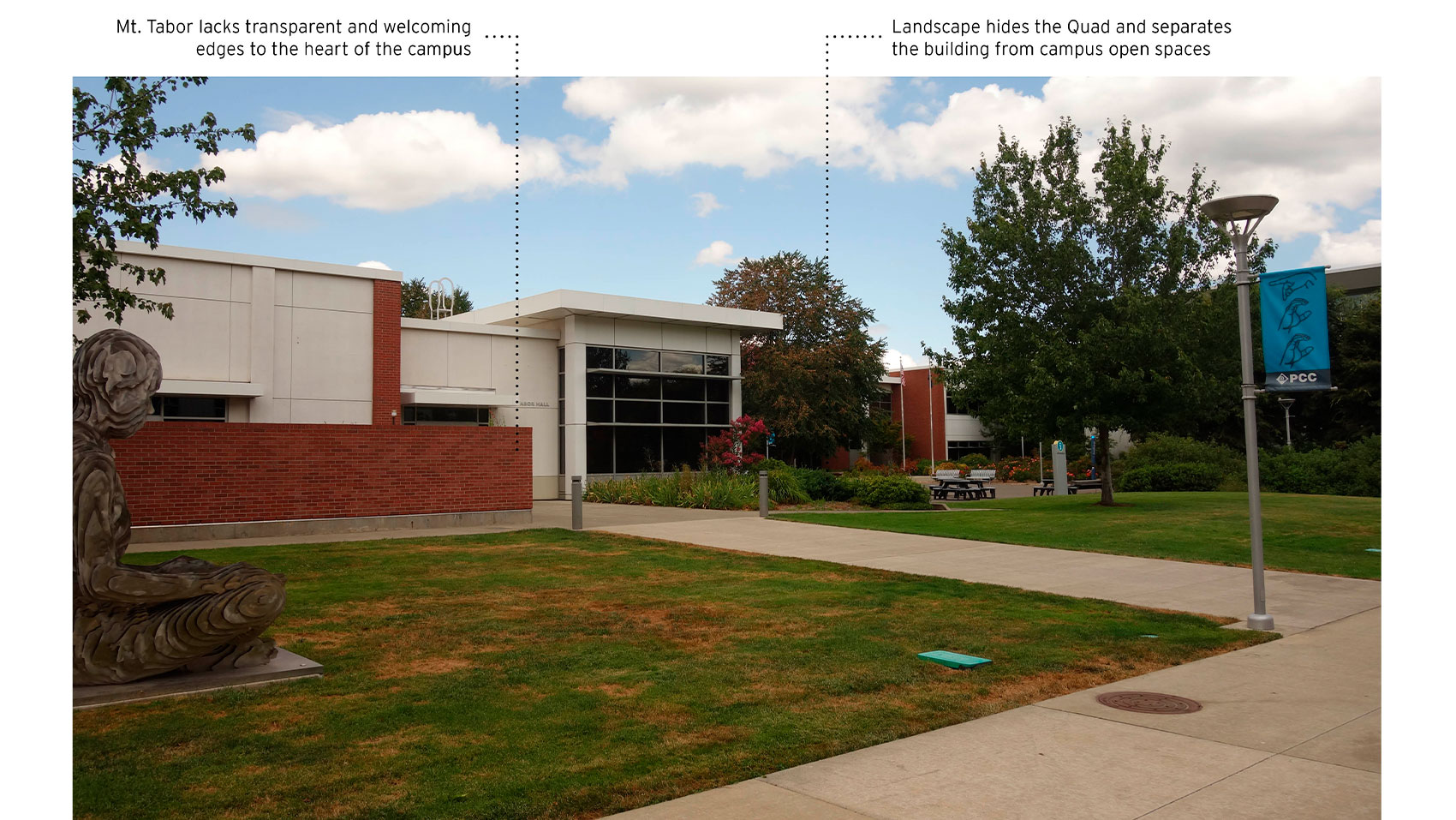
Mt. Tabor Hall
A photograph of the lawn in front of Mt. Tabor Hall in the foreground and the brick wall on the south side of Mt. Tabor Hall building in the background. The Reader sculpture is visible to the left. The Quad seating area is somewhat hidden in the background. The building is labeled “Mt. Tabor lacks transparent and welcoming edges to the heart of campus”. Another label reads “Landscape hides the Quad and separates the building from campus open spaces”.
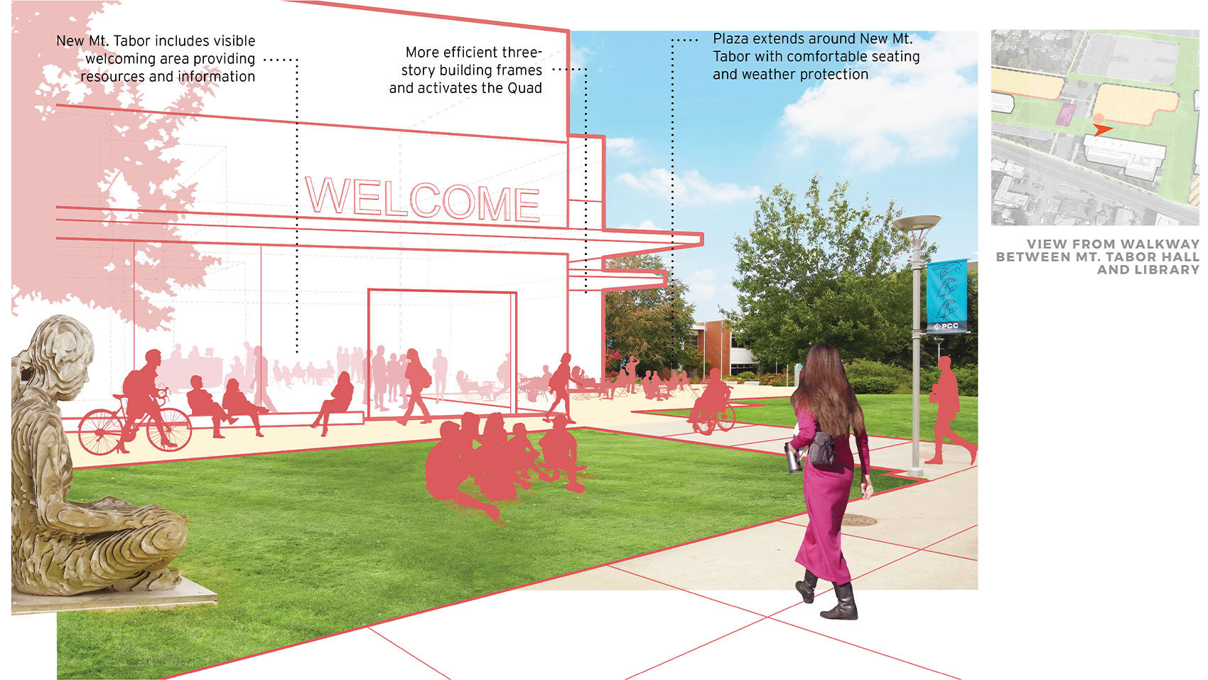
Mt. Tabor Hall Concept
Artist’s rendering of the same view. Mt. Tabor Hall is replaced with a three-story building with welcoming entrances along the Quad and canopies at the first floor that provide weather protection for outdoor seating. Silhouettes of students can be seen inside the ground floor of the building and outside in the Quad and on the lawn. A key map shows an orange arrow pointing east between the library and the new Mt. Tabor development area, labeled “view from walkway between Mt. Tabor Hall and Library”.


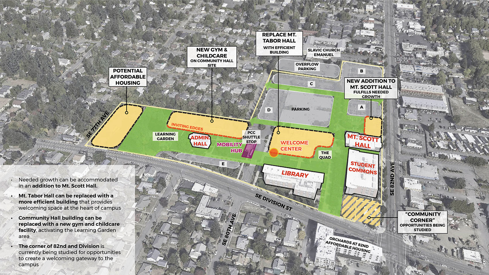


The future development areas accommodate the projected space need in the next ten years and beyond.
- The needed growth can be accommodated in a small addition to Mt. Scott Hall.
- The existing Mt. Tabor Hall (formerly a grocery store) is a large, single-story building, which could better serve students if replaced with a more efficient building that provides visible, welcoming space at the heart of campus, activating the Quad and helping students get oriented.
- The existing Community Hall building could be replaced with a new gym and childcare facility that embraces and activates the Learning Garden area.
- The far west edge of the campus is a suitable site for potential affordable housing open to the community.
- The corner at 82nd Ave. and Division St. could include a more welcoming entry to the campus that connects with the surrounding community.
Future Development Areas

Opportunities for Improvement
PCC students and staff told us that some spaces inside Mt. Tabor Hall are not comfortable or functional. Replacing Mt. Tabor Hall with a new, more efficient, and more welcoming building is a priority project being considered for potential 2022 Bond funding.
The image below envisions the potential of a new Mt. Tabor Hall to provide a public atmosphere at the heart of the campus, with a visible and open welcoming area providing student resources and campus information.
View of Mt. Tabor from Central Walkway
New Mt. Tabor Activates the Quad
(click images to enlarge)
Image gallery contents:
Existing Campus
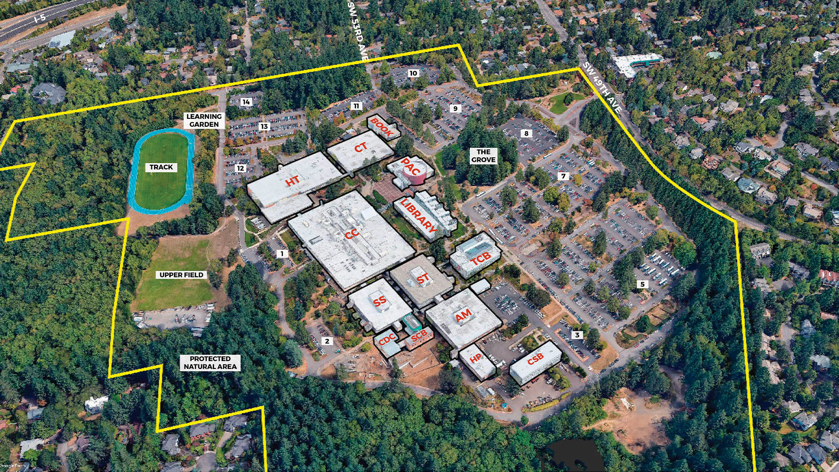
An aerial photograph view looking down at the Sylvania Campus from a southern angle, showing the surrounding streets and neighborhoods. Southwest 49th Avenue is visible at the top right, and I-5 is visible in the top left. The campus buildings are in the center of the view, outlined in white and labeled in red. The forest is labeled “protected natural area”. The Grove, learning garden, track, upper field, and parking lots are labeled. A yellow line indicates the campus boundary.
Concept 1
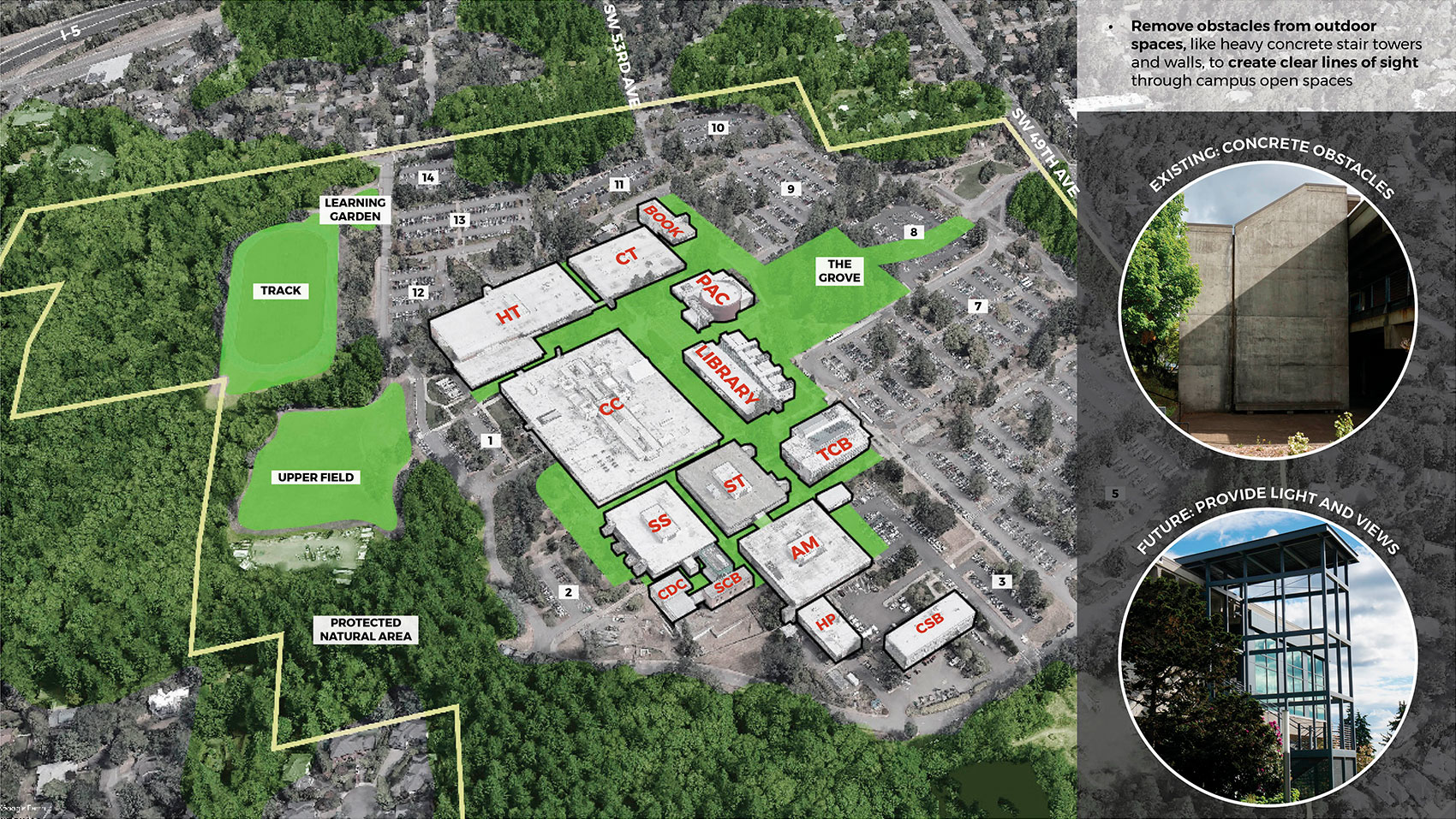
The same aerial photograph view as shown in the Existing Campus image, but slightly faded to black and white. A bright green color fills and connects the important outdoor areas in the center of campus, including the Grove. The track, learning garden, and upper field are also colored green. To the right, text reads: “remove obstacles from outdoor spaces, like heavy concrete stair towers and walls, to create clear lines of sight through campus open spaces.” Below the text are two photos of the existing campus. The first shows an existing stair tower with solid concrete walls around it labeled “existing: concrete obstacles”. The second photo shows the new stair tower on the north side of the CC building that has a shelter over it but is open at the sides, labeled “future: provide light and views”.
Concept 2
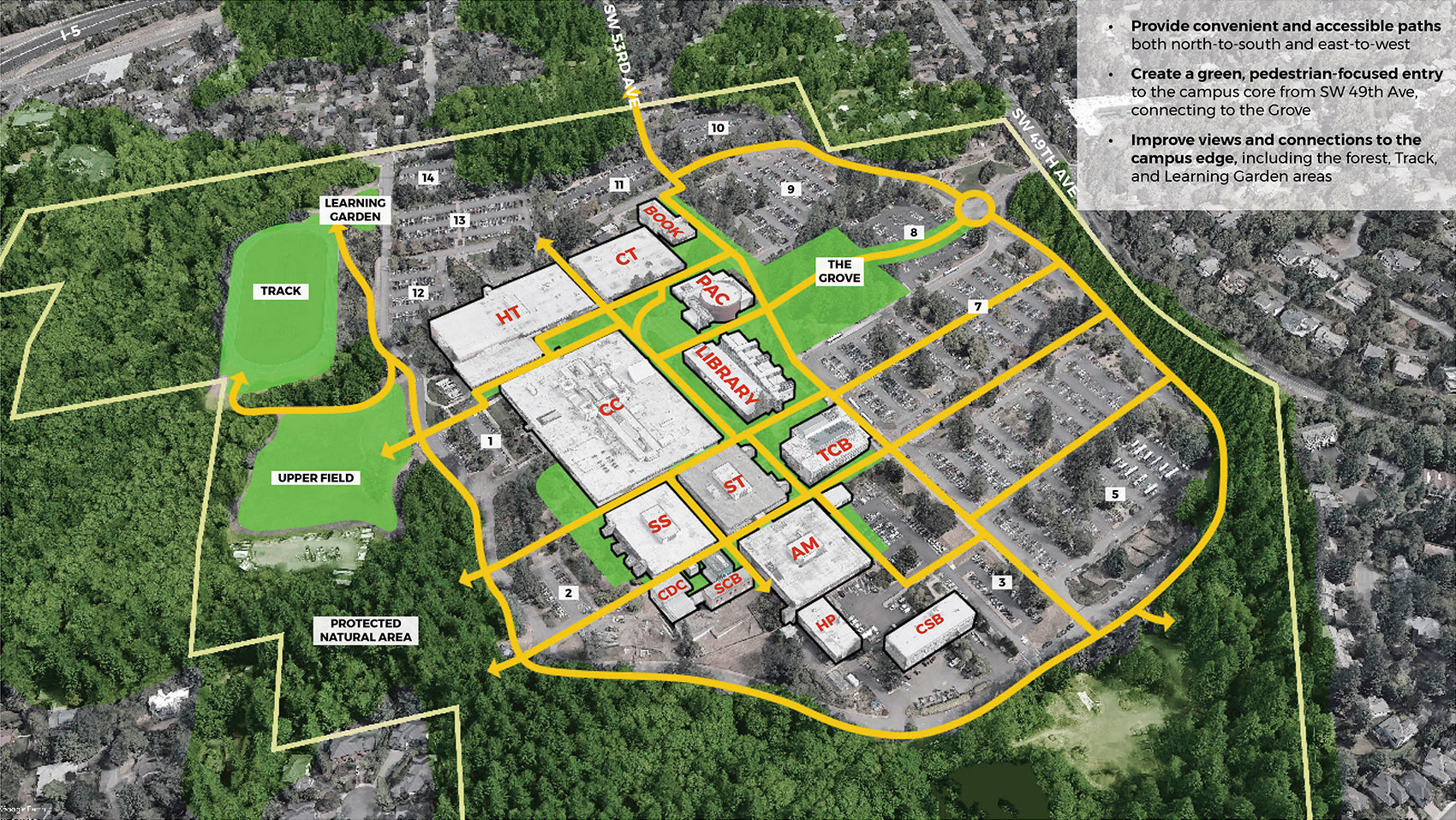
The same aerial image as campus planning concept 1, but with a network of yellow arrows indicating pedestrian pathways connected within and through the campus. The yellow paths connect from the entry at 49th Avenue, through the Grove, in between the campus buildings, and through to a loop around G street and the forested edge of campus. Arrows are shown connecting to existing trails in the forest.


We heard about what is cherished on campus and important to preserve, such as:
- Green spaces, like the Grove, the Learning Garden, and the Track area
- Its spectacular views and the forested area with trails
- The CC building as a campus “hub” for student resources
Based on college and community input and projected campus growth, future development at Sylvania Campus should:
- Remove obstacles to light and views in campus outdoor spaces
- Provide convenient and accessible paths
- Create a green, pedestrian-focused entry to the campus core from the entry along SW 49th Ave, connecting the Grove to the campus entry
- Improve views and pedestrian connections to the forested edge
Existing Sylvania Campus
Campus Planning Concept 1
Campus Planning Concept 2
(click images to enlarge)
Image gallery contents:
Future Development
The same aerial photograph view as shown in the Campus Planning Concept image. Three areas of the campus have an orange fill with a dashed black outline, indicating future development areas. One area is shown in an L shape, with its long edge facing the Bookstore to the west and the shorter edge facing the Grove to the south. It is labeled “growth option 1”. The second orange area is a rectangle along the south edge of the grove, labeled “growth option 2”. The third is shown at the northeast corner of campus on Parking Lot 10, labeled “potential affordable housing”. Options 1 and 2 have bright red edges where they face the Grove and parts of the existing campus, labeled “inviting edges”. An orange dot and purple rectangle are shown at the edge of TCB at the existing shuttle stop, labeled “Welcome Center” and “Mobility Hub”. At the top right of the image, a white box contains text describing each development area.
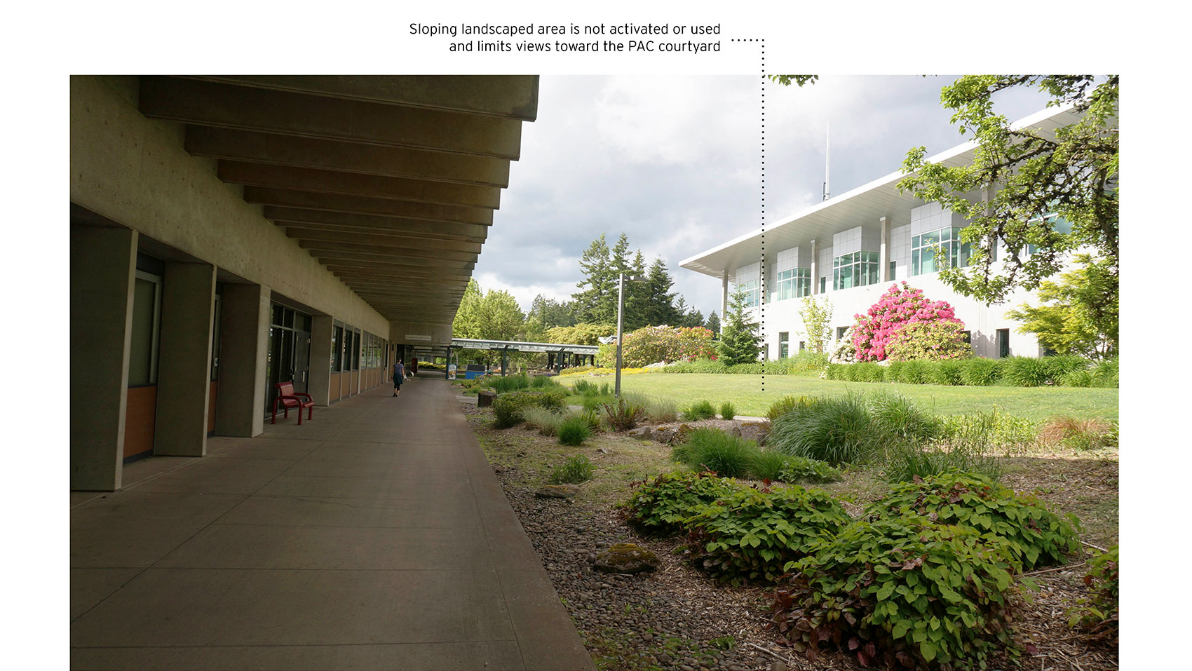
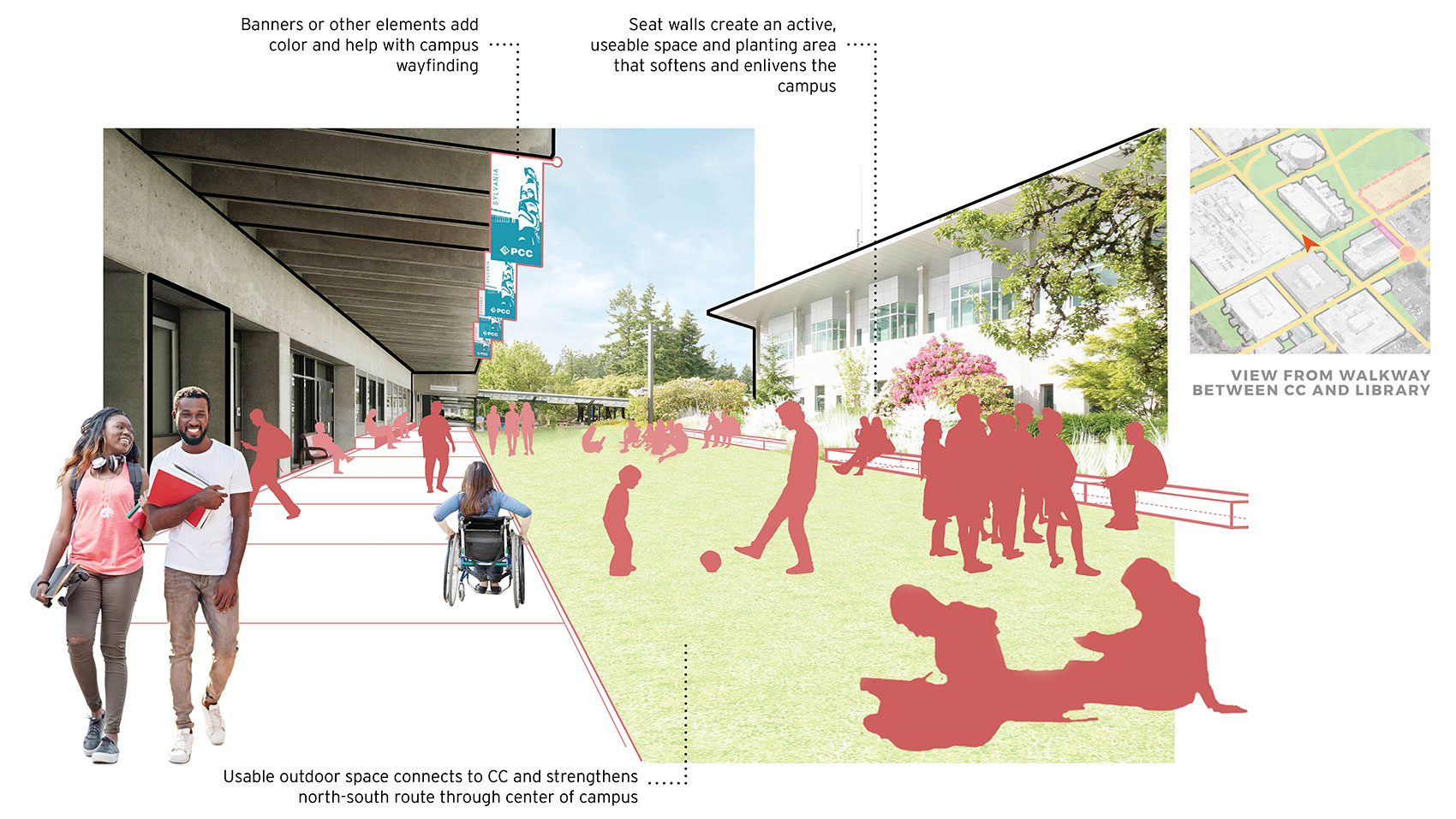
Corridor between CC and Library
Photograph taken from the southeast corner of the CC building, under the covered walkway, looking north towards the Performing Arts Center courtyard. The Library is visible on the far right. The area between CC and library is labeled, “Sloping landscaped area is not activated or used and limits views toward the PAC courtyard”.
Future Concept Graphic
Artist’s rendering of the same view. The sloping landscaped area has been flattened into a usable outdoor space with seating and gathering areas. There are silhouettes of groups of students relaxing and studying in the outdoor space. A student in a wheelchair and two students walking are seen in the foreground next to the CC building. PCC banners are shown hanging under the cover of the walkway. Labels read, “Banners or other elements add color and help with campus wayfinding”; “Usable outdoor space connects to CC and strengthens north-south route through center of campus”; and “Seat walls create an active useable space and planting area that softens and enlivens the campus”. A key map shows an orange arrow pointing north between CC and the Library, labeled “view from walkway between CC and Library.”


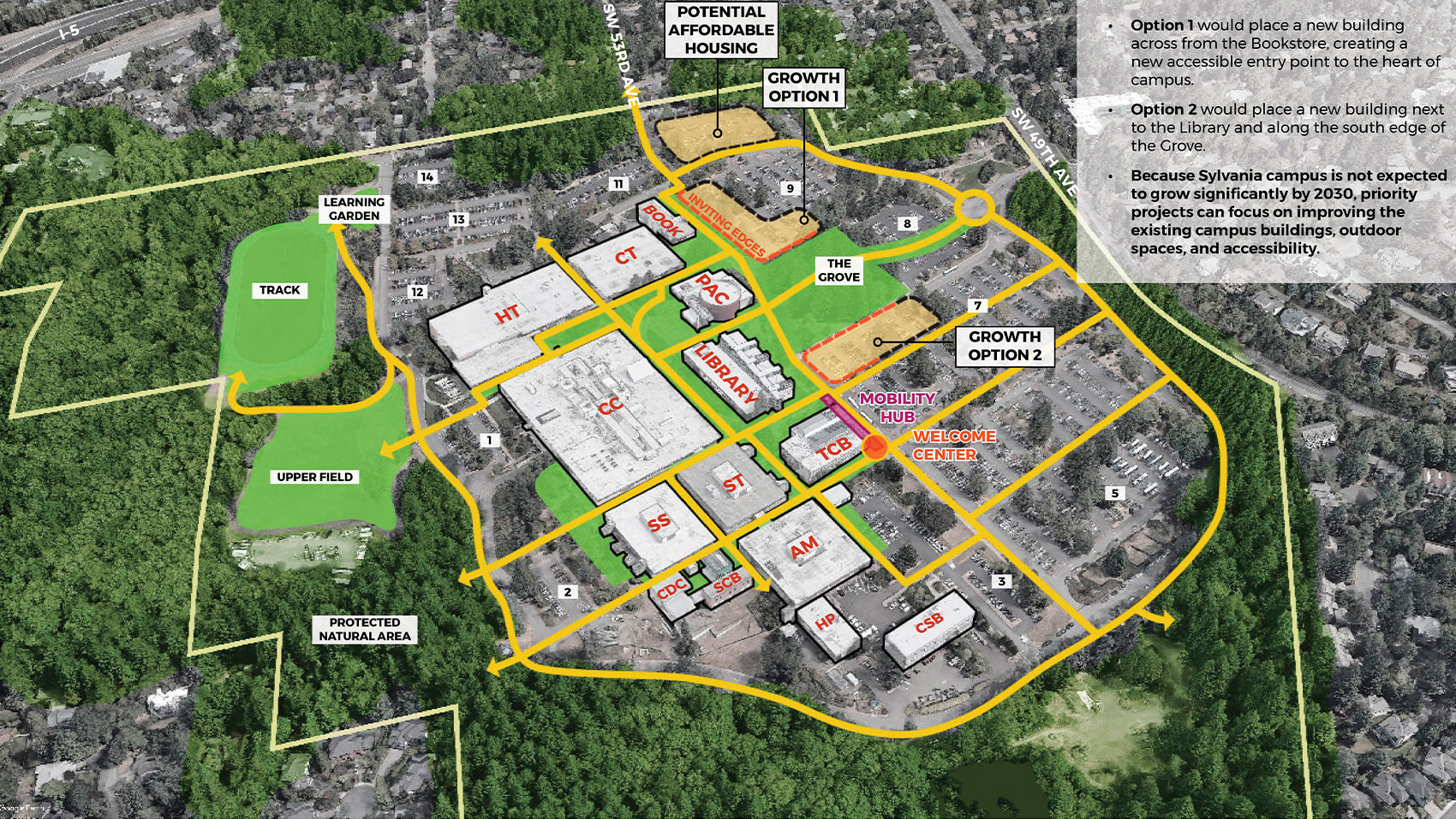

Future growth can be accommodated in one of two areas:
- Option 1 would place a new building across from the Bookstore, creating a new accessible entry point to the heart of campus.
- Option 2 would place a new building next to the Library and along the south edge of the Grove, with an opportunity to activate the transit waiting area behind the Library.
Because Sylvania campus is not expected to grow significantly by 2030, PCC is not planning to build a new academic building in the near future. Instead, priority projects at this campus can focus on improving existing campus buildings (such as the Communications Technology (CT) building), outdoor spaces, and accessibility.
- The transit waiting area can be improved as a “mobility hub” that could use part of the Technology Classroom Building (TCB) as an indoor waiting and welcome area.
- Outdoor spaces can be improved for accessibility and wayfinding throughout the campus.
- Affordable community housing could be built on parking lot 10 at the north edge of campus.
Future Development Areas

Opportunities for Improvement
An example of how the existing campus environment could be made more active and welcoming is seen here, between the College Center (CC) and Library.
The image below envisions how the renovation of this space could activate and enliven the campus, adding outdoor gathering space, color, and better navigability through the heart of campus. By flattening out the area next to CC, it can be made into usable space that could include lawn, plaza, and seating areas.
View North between CC and Library

Clear and Central Campus Corridor
(click images to enlarge)
What's next?
With your feedback, we’ll refine these draft concepts and ideas and finalize a Facilities Plan in December 2021. After the plan report is complete, there will be plenty of opportunities to get involved in the design of individual projects in the future.
For More Information
- Visit the project website
- Contact: Rebecca Ocken
Office of Planning and Capital Construction
rebecca.ocken@pcc.edu
Final Questions
We'd appreciate knowing your relationship to PCC.
Demographic Questions
We are requesting the following demographic information to help evaluate the effectiveness of our public outreach activities. Providing this information is voluntary.
The option to review and submit answers will appear after you answer at least one question.
