Where do you live (in or near)? (Please choose the location of your primary residence.)
(Check one.) This site may be easier to use if viewed in the "landscape" orientation.

Stations
Go directly to a station using the buttons below, or at the top of the screen to move through the stations in order. You can review and provide feedback on any or all of the areas that interest you. You do not have to visit every page or answer every question.
1
Learn about the project purpose and need.
2
Enter our drawing and tell us a little about how you use transit.
3
Explore routing alternatives for connections within the west side of the TriMet Service Area.
4
Explore regional connections in the east TriMet service area.
5
Explore regional connections in southeast Clackamas County.
6
Submit your feedback, learn about next steps and how to stay involved in the project.
= Page includes questions or opportunities for comment.
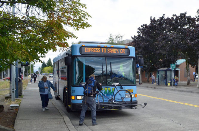
Sandy Area Metro
This project will consider...
- New Corridors: New regional connections have been identified to serve areas that currently lack local service, especially those with underrepresented communities.
- Minor Changes to Existing Routes: Existing service could be modified to meet the needs of an area or corridor.
- Service Enhancements: Potential service enhancements have been identified by looking at service span and frequency, service hours, walking and bicycling access, and ease of use. This could include changes such as increasing route frequencies or providing bus service earlier in the morning and later in the evening. Ease of use considers improving technologies such as real-time vehicle arrival, so you know when exactly the bus will arrive, and fare payment options across different transit systems.
This online open house will give you an opportunity to learn about existing transit gaps, possible solutions for filling these gaps and allow you to weigh-in on what potential new bus connections and service enhancements you would like to see in your community.

Sandy Area Metro (SAM)
Questions
Participants will be entered into a drawing for a $25 gift card to a grocery store of their choice. If you would like to be entered, please provide your name, email address, and phone number:
Please select all bus or MAX/light-rail companies that you have used to ride a bus or MAX/light-rail train in Clackamas County last year (prior to the pandemic outbreak).
(Check all that apply.)Please rank the following service improvements by order of importance to you.
Click and drag the options listed below into this box, then arrange by priority.
- Providing new connections and new local services that are not available today. Not ranked.
- Enhancing and improving existing services. Not ranked.
- Improving bicycle and pedestrian connections to transit. Not ranked.
- Improving bus stops with amenities such as shelters, benches, bike parking, and lighting. Not ranked.
- Providing information and tools such as real-time vehicle arrival, which allows you to see whether a bus is running on-time or late. Not ranked.
- Providing fare payment options, such as monthly passes or passes that work across different transit providers. Not ranked.
Click the tabs below to review and provide feedback on any service options that interest you. (You do not have to answer all questions.)
Option 1
Express route on I-205
- Bus comes every 67 minutes, allowing for 12 round trips per day operated by one full-time bus.
- Faster than Borland option.
Option 2
Local route along Borland
- Bus comes every 87 minutes, allowing for 9 round trips per day operated by one full-time bus.
- Provides more area coverage than I-205 option.
Review the routes on the map, then answer the questions at the bottom of the page.
Map: Click the  icon in the upper left to see the proposed route locations. Click each route name to learn more. Some routes overlap: click checkboxes
  to turn lines on and off to view routes underneath.
Questions
Option 1
Line 36 Extension
Extending TriMet Line 36, which currently operates between Tualatin and Lake Oswego, to West Linn’s Willamette neighborhood via Highway 43
- Future connection to the Southwest Corridor Light Rail Bridgeport Transit Center Station.
- Would add 72 minutes over existing service, allowing for 7 round trips per day operated by one additional full-time bus.
Option 2
Line 37 Extension
Rerouting and extending TriMet Line 37 to West Linn’s Willamette neighborhood via Highway 43, and incorporating TriMet’s proposed changes to Line 37 (as outlined in the Southwest Service Enhancement Plan) to reroute west from Lake Oswego to Tigard and Murrayhill.
- Existing Connection to WES Commuter Rail and future connection to the Southwest Corridor Light Rail Bonita Station.
- Would add 120 minutes over existing service, allowing for 5 round trips per day operated by one additional full-time bus.
Option 3
New Fixed Route Service
New service between West Linn, Lake Oswego, and Tigard along Rosemont Road to the west of Highway 43.
- The portion of the route between West Linn and Lake Oswego is identified in TriMet’s Southwest Service Enhancement Plan.
- Bus comes every 125 minutes, allowing for 6 round trips per day operated by one full-time bus.
Considerations
- Reliability on long routes. Schedules are harder to keep on long routes, and mechanical breakdowns could occur far from maintenance facilities.
- Non-linear routes. Lake Oswego is outside the best direction of travel between West Linn and Tualatin.
Possible solutions:
- Add a transit center or mobility hub.
- Add a route along Borland Road.
Review the routes on the map, then answer the questions at the bottom of the page.
Map: Click the icon in the upper left to see the proposed route locations. Click each route name to learn more. Some routes overlap: click checkboxes to turn lines on and off to view routes underneath.
Questions
How likely are you to use Option 1, extending TriMet Line 36?
(Check one.)How likely are you to use Option 2, rerouting and extending TriMet Line 37 to West Linn’s Willamette neighborhood via Highway 43?
(Check one.)How likely are you to use Option 3, a new service between West Linn, Lake Oswego, and Tigard along Rosemont Road to the west of Highway 43?
(Check one.)When would you most likely ride this bus?
(Check one.)Option 1
Oak Grove to Clackamas Town Center
- Bus comes every 50 minutes, allowing for 16 round-trips per day operated by one full-time bus.
Option 2
Oak Grove to Clackamas Town Center via Clackamas Industrial Area
- Bus comes every 64 minutes, allowing for 12 round-trips per day operated by one full-time bus.
Option 3
Oregon City to Happy Valley via Jennings Lodge and Clackamas Industrial Area
- Bus comes every 86 minutes, allowing for 9 round-trips per day operated by one full-time bus.
Review the routes on the map, then answer the questions at the bottom of the page.
Map: Click the icon in the upper left to see the proposed route locations. Click each route name to learn more. Some routes overlap: click checkboxes to turn lines on and off to view routes underneath.
Questions
How likely are you to use Option 1, which provides service to Clackamas Town Center?
(Check one.)How likely are you to use Option 2, which provides service to the Clackamas Industrial Area and Clackamas Town Center?
(Check one.)How likely are you to use Option 3, which provides service to Oregon City, the Clackamas Industrial Area, and Happy Valley?
(Check one.)When would you most likely ride this bus?
(Check one.)Click the tabs below to review and provide feedback on any service options that interest you. (You do not have to answer all questions.)
Option 1
Service to the Rockwood MAX station
- Bus comes every 69 minutes, allowing for 11 round-trips per day operated by one full-time bus.
Option 2
Service to Powell Boulevard
- Bus comes every 52 minutes, allowing for 15 round-trips per day operated by one full-time bus.
Considerations
Both routes assume construction of the new 172nd–190th Connector, completing the C2C mainline.
The northern ends of both routes connect with TriMet frequent-service routes.
- Potential park-and-ride location: the 181st Ave. MAX station one stop west of Rockwood.
- Buses could turn around at 185th and Stark or at the Rockwood station.
A mobility hub at the transfer point would better connect north–south service on the C2C with east–west service on the Powell bus line and on MAX. This would help people in the C2C corridor reach east Multnomah County, including Gresham and Sandy.
Review the routes on the map, then answer the questions at the bottom of the page.
Map: Click the icon in the upper left to see the proposed route locations. Click each route name to learn more. Some routes overlap: click checkboxes to turn lines on and off to view routes underneath.
Questions
Option 1
New Loop Service
- Bus comes every 30 minutes, allowing for 26 round-trips per day operated by one full-time bus.
Option 2
New Line Service
- Bus comes every 33 minutes, allowing for 23 round-trips per day operated by one full-time bus.
Option 3
New Damascus–Boring Service with Deviation
- Bus comes every 65 minutes, allowing for 12 round-trips per day operated by one full-time bus.
- This route travels through a less populated area and could reach more rural areas.
Considerations
Each option needs a bus turnaround location.
The proposed Sandy to Clackamas Town Center route would run through Damascus and along Highway 212, with transfers possible between local and regional service.
Review the routes on the map, then answer the questions at the bottom of the page.
Map: Click the icon in the upper left to see the proposed route locations. Click each route name to learn more. Some routes overlap: click checkboxes to turn lines on and off to view routes underneath.
Questions
How likely are you to use Option 1, a new loop service in Damascus?
(Check one.)How likely are you to use Option 2, a new line service through Damascus?
(Check one.)How likely are you to use Option 3, a new deviated route service between Damascus and Boring?
(Check one.)When would you most likely ride this bus?
(Check one.)Option 1
Line to the north of Sunnyside
- Bus comes every 52 minutes, allowing for 15 round-trips per day operated by one full-time bus.
Option 2
Line along Sunnyside and Highway 212
- Bus comes every 87 minutes, allowing for 9 round-trips per day operated by one full-time bus.
Considerations
Option 2 would duplicate existing TriMet service on Sunnyside Road.
Buses might be too wide for some of these roads.
Review the routes on the map, then answer the questions at the bottom of the page.
Map: Click the icon in the upper left to see the proposed route locations. Click each route name to learn more. Some routes overlap: click checkboxes to turn lines on and off to view routes underneath.
Questions
Option 1
New local service:
- Bus comes every 44 minutes, allowing for 18 round-trips per day operated by one full-time bus.
Option 2
Demand-response
- Demand-response means that a rider calls to make a reservation in advance and the bus comes to their location.
- Could accommodate about 3 trips per hour, most often with a single rider onboard.
Considerations
With this area's low population density, demand-response service might do better at making timed connections to Line 30.
Estacada-Redland-Oregon City deviated, fixed-route service could cover this as well. (See Station 5.)
Review the routes on the map, then answer the questions at the bottom of the page.
Map: Click the icon in the upper left to see the proposed route locations. Click each route name to learn more. Some routes overlap: click checkboxes to turn lines on and off to view routes underneath.
Questions
Click the tabs below to review and provide feedback on any service options that interest you. (You do not have to answer all questions.)
Option 1
New intercity service on Highway 212
- Bus comes every 113 minutes, allowing for 5 round-trips per day operated by one full-time bus.
Option 2
Intercity service on Sunnyside Road
- Bus comes every 104 minutes, allowing for 6 round-trips per day operated by one full-time bus.
Option 3
Mt. Hood Express Extension
- Bus comes every 230 minutes (96 more minutes than the existing Mt. Hood Express), allowing for 5 round-trips per day operated by one additional full-time bus (on top of the existing bus).
Considerations
Reliability on long routes: Schedules are harder to keep, and mechanical breakdowns could occur far from maintenance facilities.
The Mt. Hood Express extension (rather than new service) would reduce the number of transfers from Sandy to Clackamas Town Center.
Review the routes on the map, then answer the questions at the bottom of the page.
Map: Click the icon in the upper left to see the proposed route locations. Click each route name to learn more. Some routes overlap: click checkboxes to turn lines on and off to view routes underneath.
Questions
How likely are you to use Option 1, a new service from Sandy to Clackamas Town Center via Highway 212?
(Check one.)How likely are you to use Option 2, a new service from Sandy to Clackamas Town Center via Sunnyside Road?
(Check one.)How likely are you to use Option 3, which provides service to Oregon City, an extension of the Mt. Hood Express to Clackamas Town Center?
(Check one.)When would you most likely ride this bus?
(Check one.)Option 1
Round-trip Woodburn–Molalla
- Bus comes every 217 minutes, allowing for 4 round-trips per day operated by one full-time bus.
Option 2
Round-trip Woodburn–Estacada
- Bus comes every 217 minutes, allowing for 4 round-trips per day operated by one full-time bus.
Considerations
Option 2 means a one-seat ride between Estacada and Woodburn, but also a longer route. Schedules could be harder to keep, and mechanical breakdowns could occur far from maintenance facilities.
Review the routes on the map, then answer the questions at the bottom of the page.
Map: Click the icon in the upper left to see the proposed route locations. Click each route name to learn more. Some routes overlap: click checkboxes to turn lines on and off to view routes underneath.
Questions
How likely are you to use Option 1, which adds a new route between Woodburn and Molalla that comes more frequently?
(Check one.)How likely are you to use Option 2, which adds a new route between Molalla, Woodburn and Estacada but comes less frequently?
(Check one.)When would you most likely ride this bus?
(Check one.)Option 1
New deviated fixed-route service on Redland Road
- 36 miles and 143 minutes, allowing for 5 round-trips per day operated by one full-time bus.
- Within 1/4 mile of the proposed route, would serve 4,178 residents and 1,719 jobs; and could be modified to cover a larger demand-response area on both ends of the route.
Option 2
Demand-response service between Estacada and South Oregon City
- Demand-response service is proposed to serve all of Estacada and south Oregon City, especially the Maplelane neighborhoods which were identified through Clackamas County Shuttles outreach for their topographic challenges and lack of pedestrian facilities.
- Service could provide three passenger trips per hour.
- Within 1/4 mile of the proposed route, would serve 4,178 residents and 1,719 jobs; and could be modified to cover a larger demand-response area on both ends of the route.
Review the routes on the map, then answer the questions at the bottom of the page.
Map: Click the icon in the upper left to see the proposed route locations. Click each route name to learn more. Some routes overlap: click checkboxes to turn lines on and off to view routes underneath.
Questions
How likely are you to use Option 1, a deviated fixed-route service that has a schedule, but could go a little off of its main route to pick-up riders?
(Check one.)How likely are you to use Option 2, a demand-response service between Estacada and South Oregon City?
(Check one.)When would you most likely ride this bus?
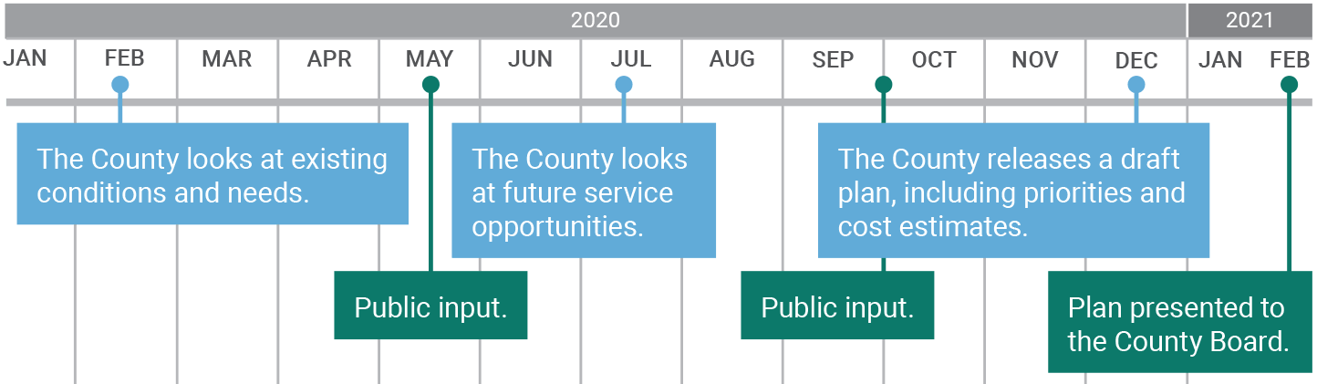
(Check one.)Timeline

Stay Informed
- Contact: Brett Setterfield - Clackamas County Project Manager
503-742-4511 or bsetterfield@clackamas.us - Sign up for email updates and learn more about the project: clackamas.us/planning/transit.