
The content on this site may take 15-20 minutes to view. You may use the links below to skip to specific information, or click "Get Started" above.

= Page includes questions or opportunities for comment.
Open house extended through midnight June 16.


What we learned
The Albany Riverfront has several distinct project areas requiring different types of expertise. We have spent the past few months researching the site history, ecology, features, access, events and relationship to the City. We have also reviewed prior planning efforts to ensure we are building on these initiatives where appropriate.
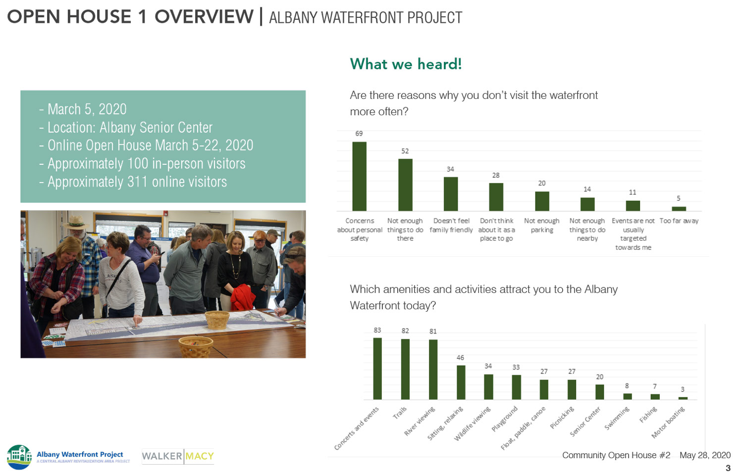
In early March we held in-person and online open houses to gather public feedback, share what we learned, and ask questions to better understand what you love about these spaces and what challenges need to be addressed. The following themes were discussed and are key elements being factored into all designs:
- Connectivity – You asked that we improve connections from downtown to the water, as well as from the water into town, and east/west along the trail. We heard about desires to access downtown and the river through many different means including running, walking, boating, and biking.
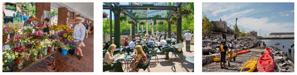
- Project Amenities – We heard that many people enjoy the summertime concert series in the park but would like more reasons to come to the waterfront to support your growing and diverse community. Some ideas included an improved playground and amphitheater, a water feature, a hand-carried boat landing and more spaces to relax and enjoy the waterfront.
- Sustainability – The feedback from the community included prioritizing environmental stewardship – recommending any design include sustainable best practices and opportunities to improve and restore habitat along the river’s edge.
- Site Character and Community Culture – The city of Albany has a long history that has developed into the rich, diverse community that is here today. It was clear in your early responses that the ultimate design for the redevelopment should honor that history and transformation, while remaining flexible to support future activities as the community evolves.
- Safety – Of all the comments received, the one most frequently repeated was a sense that the riverfront doesn’t feel safe for everyone. The redesign will address these concerns by improving lighting, connections, surveillance, and emergency access, while encouraging positive activity throughout the park and the trail.
These themes and values have guided the team and are elements within each design option we developed.
On the following pages, read how the project team has attempted to incorporate these themes into different designs and tell us what you like about each.

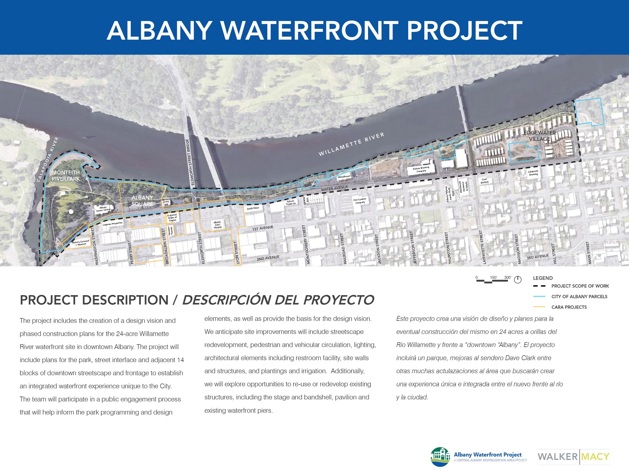
Project overview. (Click to enlarge.)

Open house 1 feedback overview. (Click to enlarge.)
Monteith Park Existing Conditions


Approach
The existing park has challenges. These include frequent flooding, limited physical and visual connections from downtown, poor accessibility through the park and to the river, and limited activities besides programmed events. These are all elements that we considered as we developed the concepts below.
Review the three Monteith Park Concepts below by clicking on the three tabs (Community Loops, Meeting Place, and Community Hub) and give us feedback.
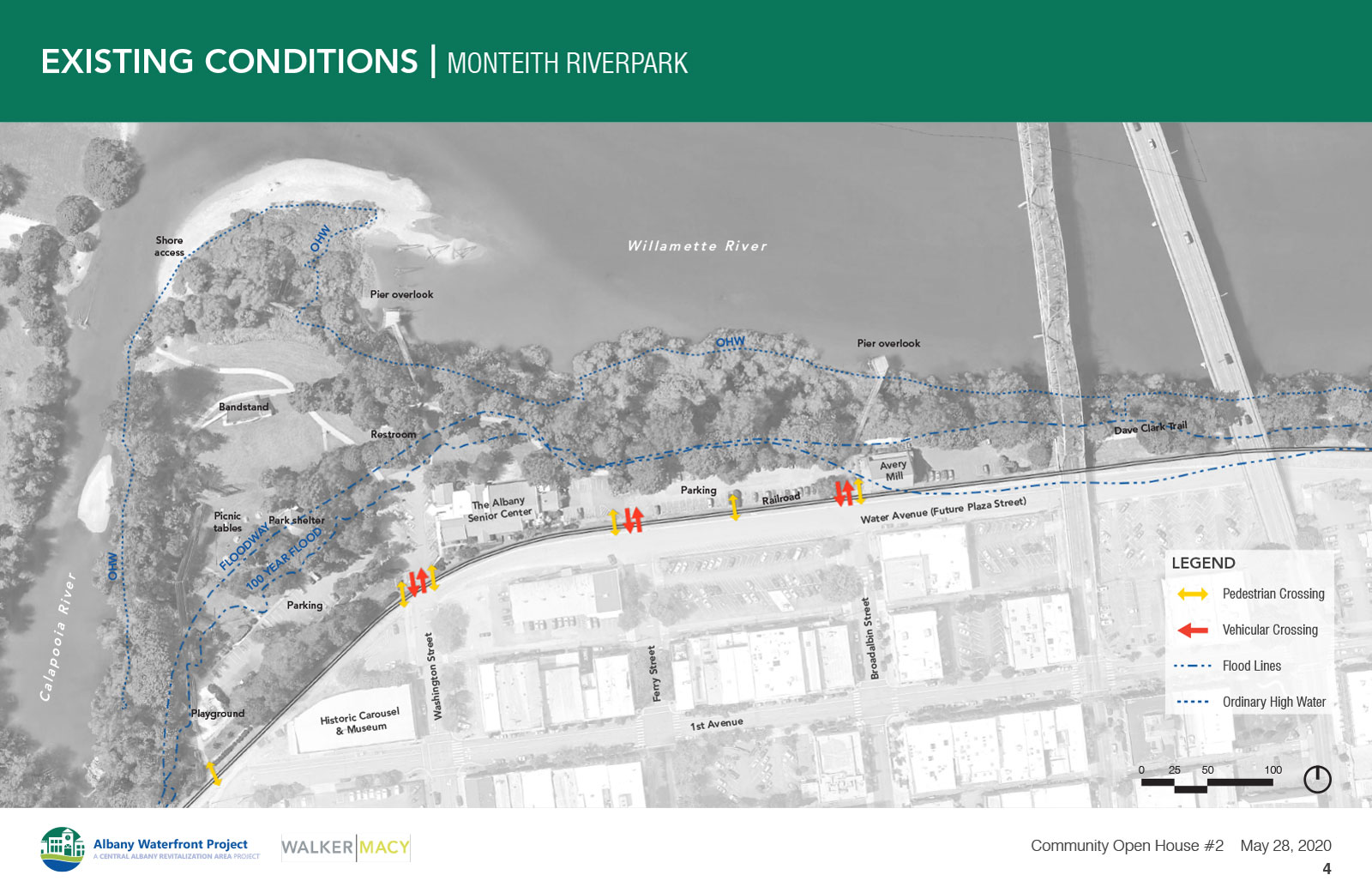
Monteith Park Existing Conditions. (Click to enlarge.)


(Click to enlarge.)
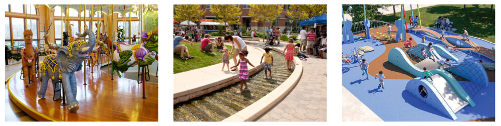
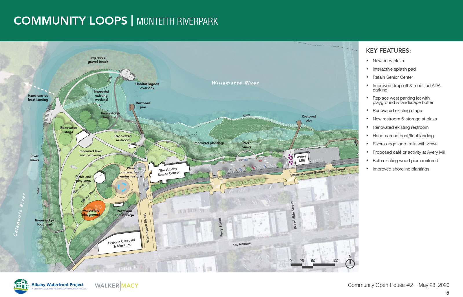
Albany has a wonderful downtown with interesting opportunities to live, shop, eat and explore. One of the focal points and major attractions is the incredible carousel, whose whirling forms, its artful playfulness, and its whimsical nature provided the inspiration for this concept.
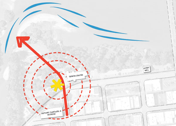
Between the existing senior center and the Carousel, near the picnic pavilion, we created a central gathering plaza with radiating paths that help define and link activity zones and step down toward the river.
Key Features
- Retain the existing senior center with improved loading/drop-off and modified parking.
- Replace the west parking lot with a family-oriented, interactive splash pad, accessible playground, and landscape buffer.
- Renovate the existing stage to better serve events.
- Provide a new restroom and storage at the central plaza and renovate the existing restroom east of the amphitheater.
- Paths to the water with seating and access for hand-carried boats and floats.
- River loop trails with views near the rivers’ edge.
- Recommended improvements for a café or similar activity at Avery Mill.
- Both existing wood piers restored.

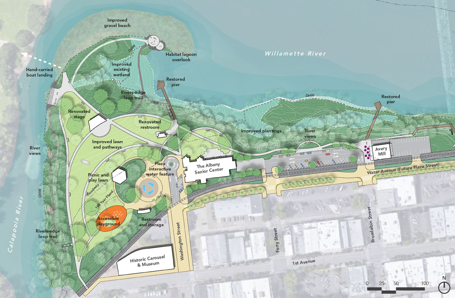
Access and Flexible Spaces
- Improved path connecting the Dave Clark trail through the site.
- New Water Avenue streetscape provides flexible event use.
- Create water views from the park and on small informal paths along the rivers’ edge.
- Modify west parking lot to provide limited ADA parking and drop off only. Improve east parking lot.
- Emergency, maintenance and event vehicular access down central pathway.
Access and flexible spaces diagram. (Click to enlarge.)
Questions


(Click to enlarge.)
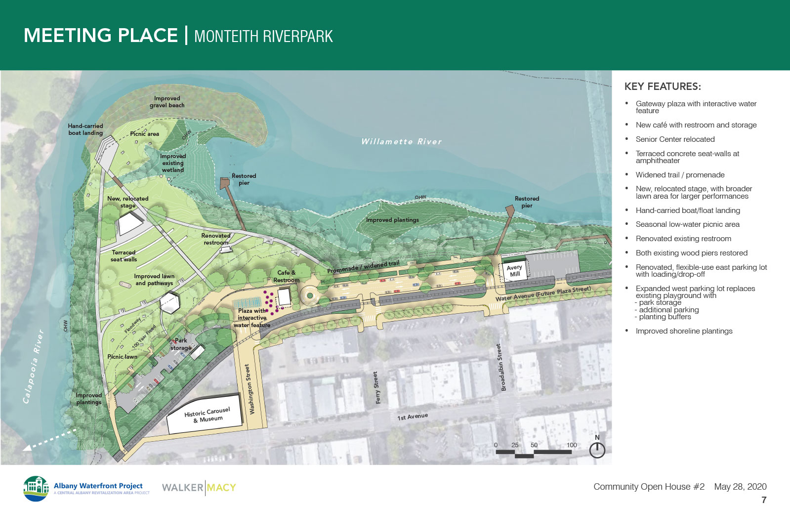
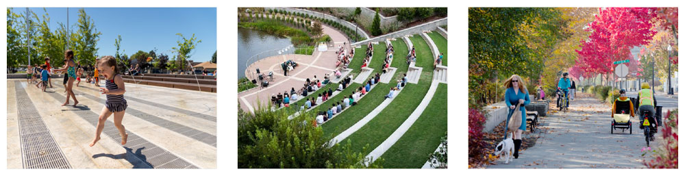
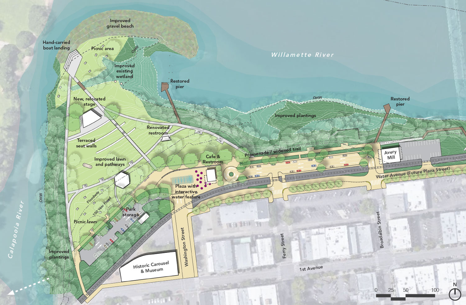
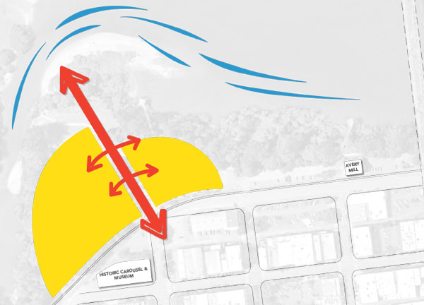
This concept creates a welcoming gateway between downtown Albany and the Park where the town, the Dave Clark Trail and the park meet. A large active plaza with an interactive water feature and adjacent café create a significant and attractive entry to the waterfront at SW Washington Street. This approach to redevelopment, combined with the already popular carousel, will generate a hub of activity that attracts people to the park at all times of the year.
From the plaza entry, direct paths provide clear access routes so community members and visitors can enjoy the riverfront activities, trail systems and the water’s edge. This option also proposes that the Dave Clark Trail takes on a widened, promenade-like condition along the gateway area that could be used for vendors and events.
Key Features
- Gateway plaza at Washington Street with an interactive water feature.
- Senior Center is relocated and site developed with a new café with restroom and storage.
- Terraced concrete seat-walls that form an amphitheater .
- Widened trail / promenade that can support event uses.
- New, relocated stage, with broader lawn area for larger performances.
- Direct paths to a hand-carried boat landing and seasonal low water picnic area.
- Renovated existing restroom.
- Both existing wood piers restored.
- Renovated, flexible-use east parking lot with loading/drop-off.
- Expanded west parking lot with Park storage, additional parking, and planting buffers that replace the existing playground.

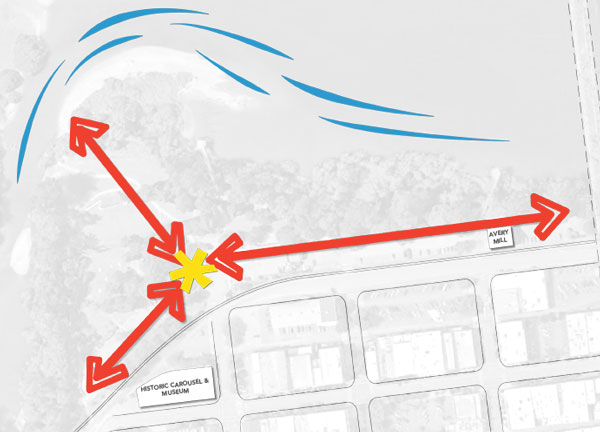
Access and Flexible Spaces
- The concept includes a wide promenade that connects to the Dave Clark trail.
- New Water Avenue streetscape provides flexible event use
- A direct path connects the gateway, the stage and the river.
- Both existing wood piers will be refurbished.
- There is an emphasis on creating a series of viewpoints from the park to the water.
- Extended west parking lot provides additional parking.
- Emergency, maintenance and event vehicular access along the west side of the park.
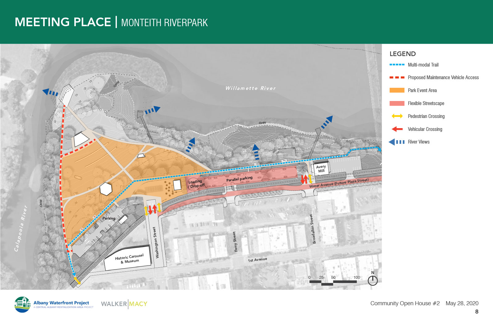
Access and flexible spaces diagram. (Click to enlarge.)
Questions


(Click to enlarge.)
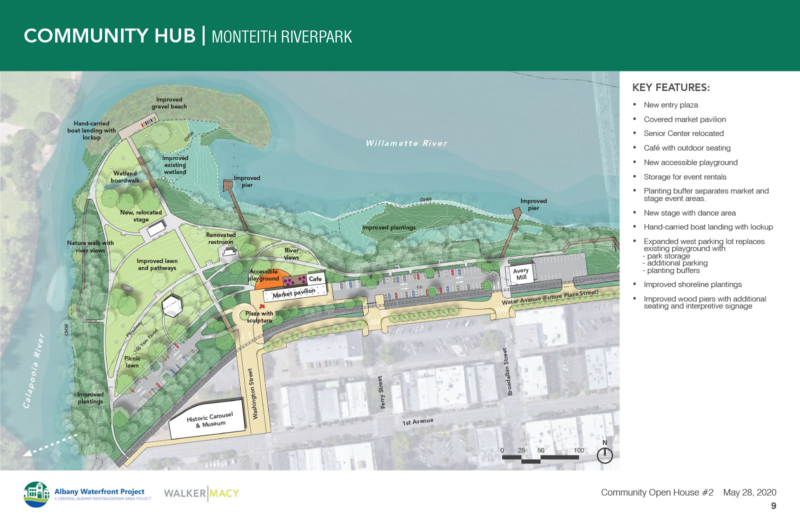
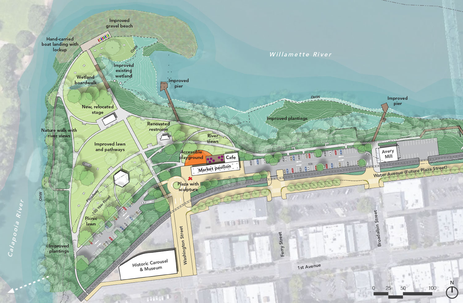
This concept imagines Monteith Park as a greater community focal point in the city. You already have a successful concert series that draws thousands each year, but there could be other programmable spaces that attract the community for a variety of activities.
From downtown, the entry into the park will be marked by a covered pavilion that can host anything from farmers or artisan markets to holiday events or beer gardens. The pavilion will be a beacon, marking the entry to the park and linking the downtown activities to the waterfront. It incorporates a café, outdoor gathering spaces and an integrated play area, and will broaden Albany’s ability to host events in the park. From the entry plaza there is a direct path to the river that bisects the park into two areas with the amphitheater on the west and the new covered pavilion on the east. This could accommodate a wide variety of small and large events where the stage and pavilion are combined, or function independently for smaller events. The pathways also link the Dave Clark Trail, the stage, a hand-carried boat landing, and other park amenities.
Key Features
- Senior Center will be relocated and a new entry plaza with a covered pavilion for markets or events will be created.
- The potential for a small café with outdoor seating and storage for event rentals.
- A new accessible playground integrated with the market pavilion plaza and adjacent lawn.
- Planting buffer and accessible pathway provides separation between the market and stage event areas.
- New stage in similar location with improved lawn, access paths, and dance area.
- New pathways lead to a hand-carried boat landing with lockup at the river’s edge.
Access and Flexible Spaces
- A direct pedestrian pathway connects from the city and entry plaza to the waterfront.
- An east/west path connects through the park and to the Dave Clark trail.
- Planting buffer with accessible paths separates market and stage event areas.
- Improved wood piers with additional seating and interpretive signage.
- Create viewpoints from the park to the water from key activity zones.
- Extended west parking lot provides additional parking.
- Emergency, maintenance and event vehicular access along the west side of the park.
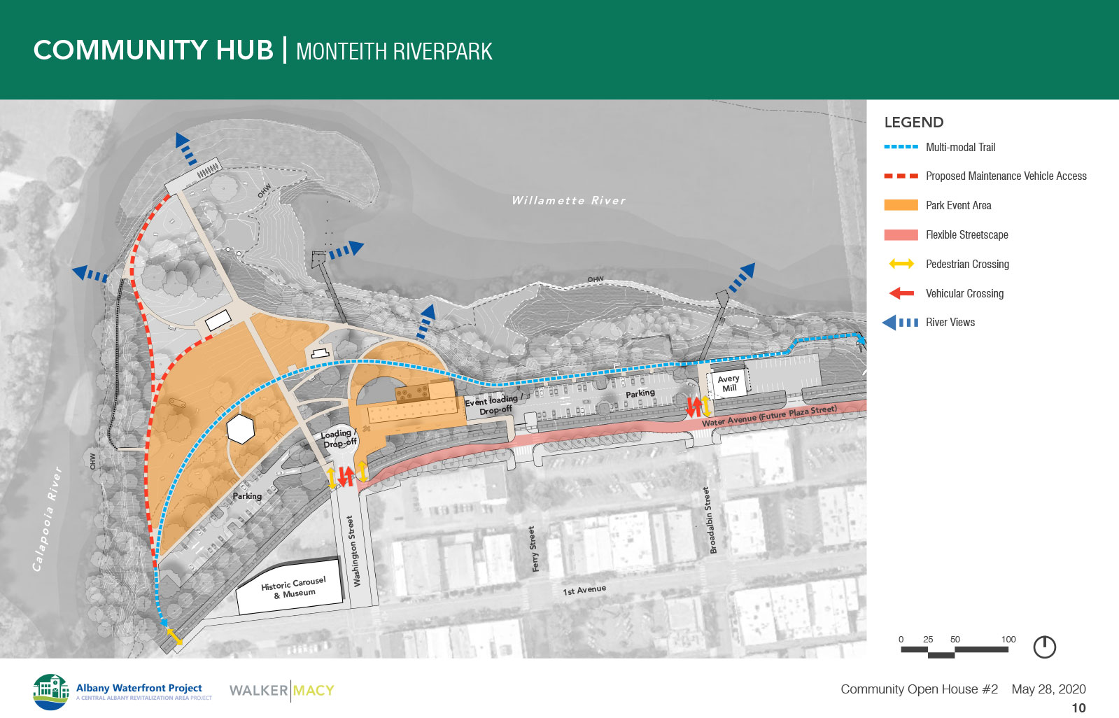
Access and flexible spaces diagram. (Click to enlarge.)
Questions
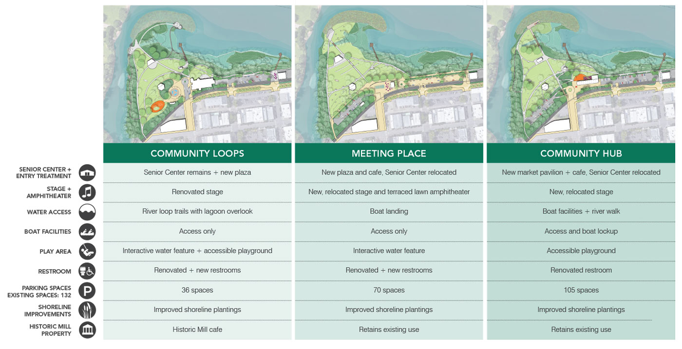
Monteith Park Design Comparison


Dave Clark Trail Overview

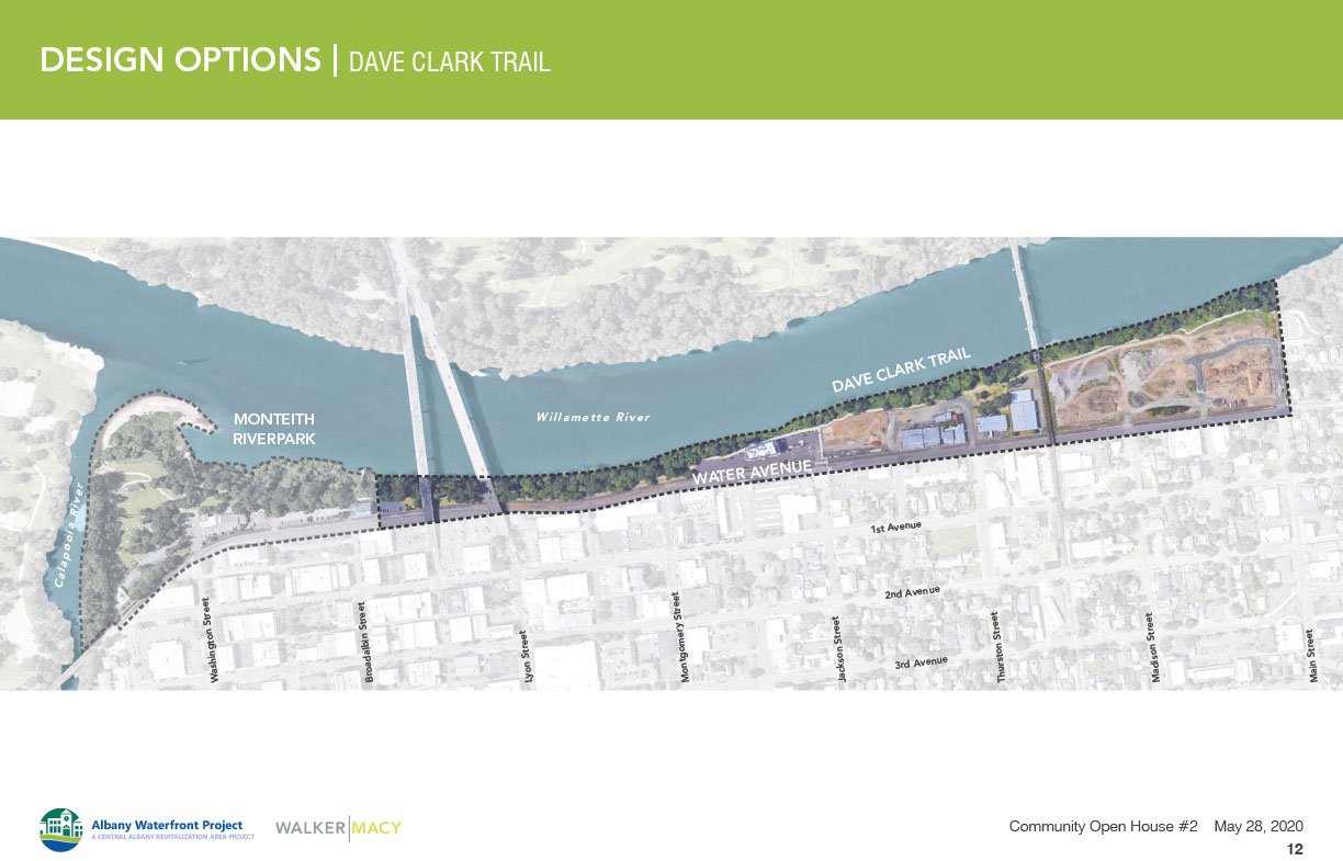
Approach
The Dave Clark Trail has challenges that include limited access points, poor lighting, safety concerns, and a lack of - or deteriorating - amenities. People expressed a desire for better river views, more opportunity for activities and seating areas, and possibly educational and interpretive elements.
The two proposed concepts for the Dave Clark Trail suggest different approaches to trail improvements that facilitate further conversation about amenities, the character of the trail, and its relationship to Albany and the river.
Please review the two concepts below and provide your feedback.


(Click images to enlarge.)

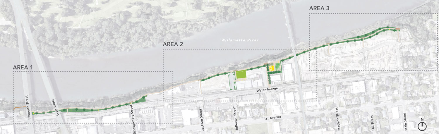
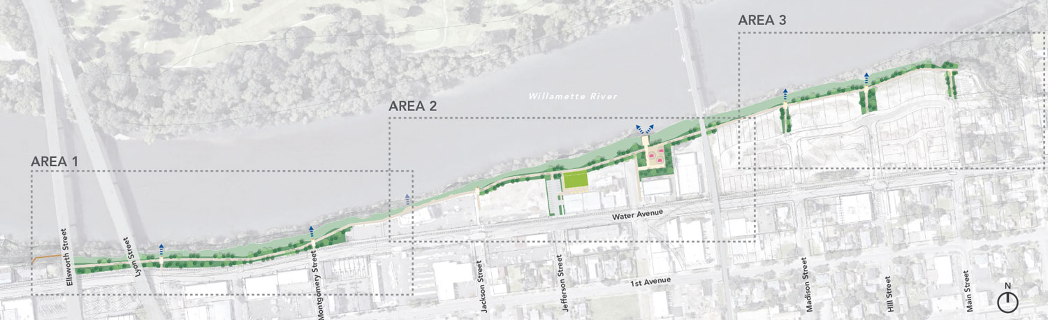
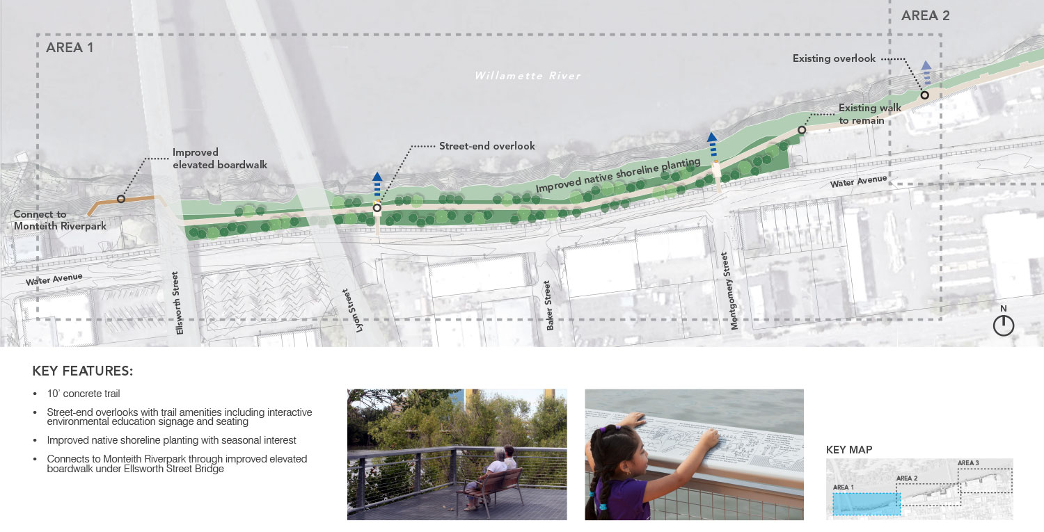
Area 1

Area 2

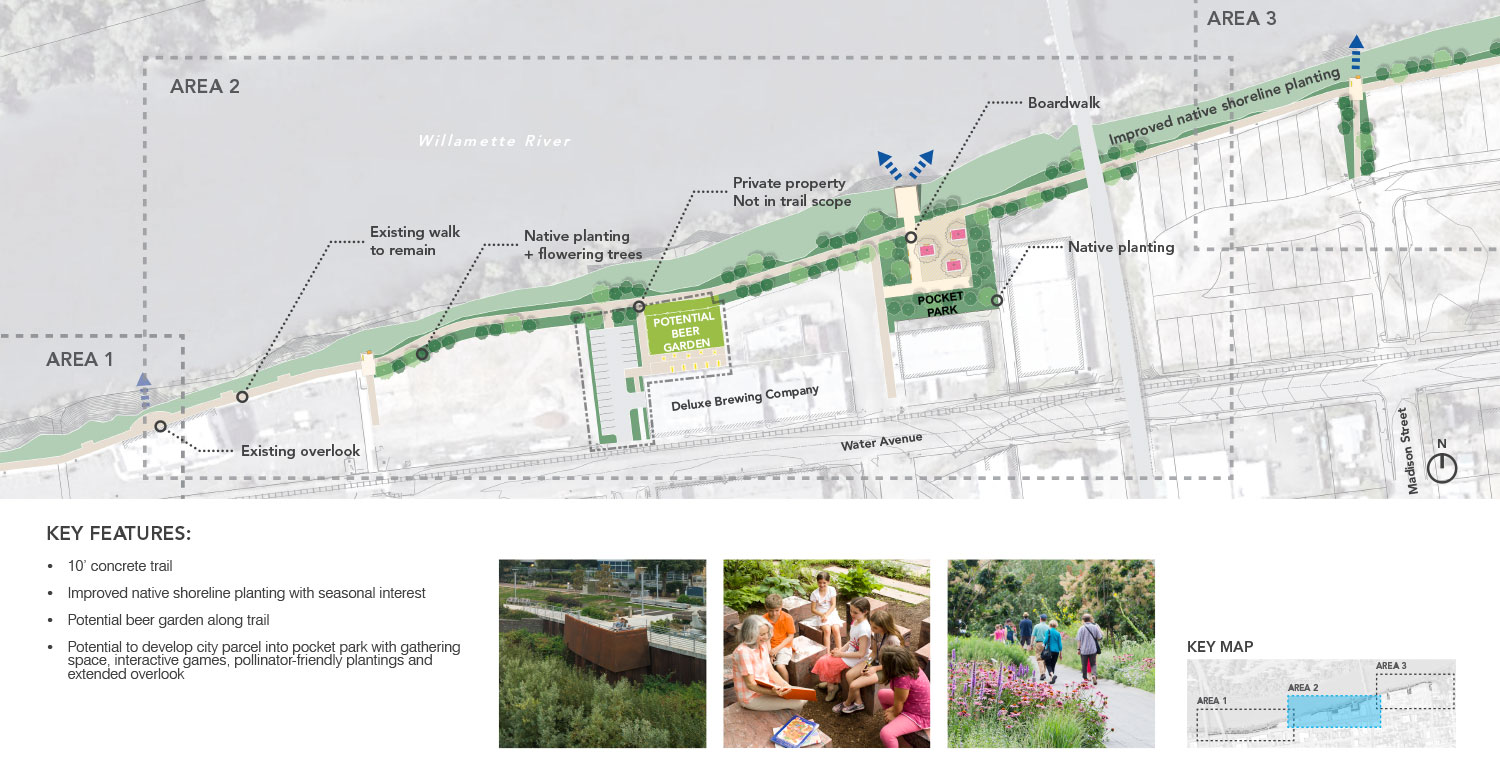
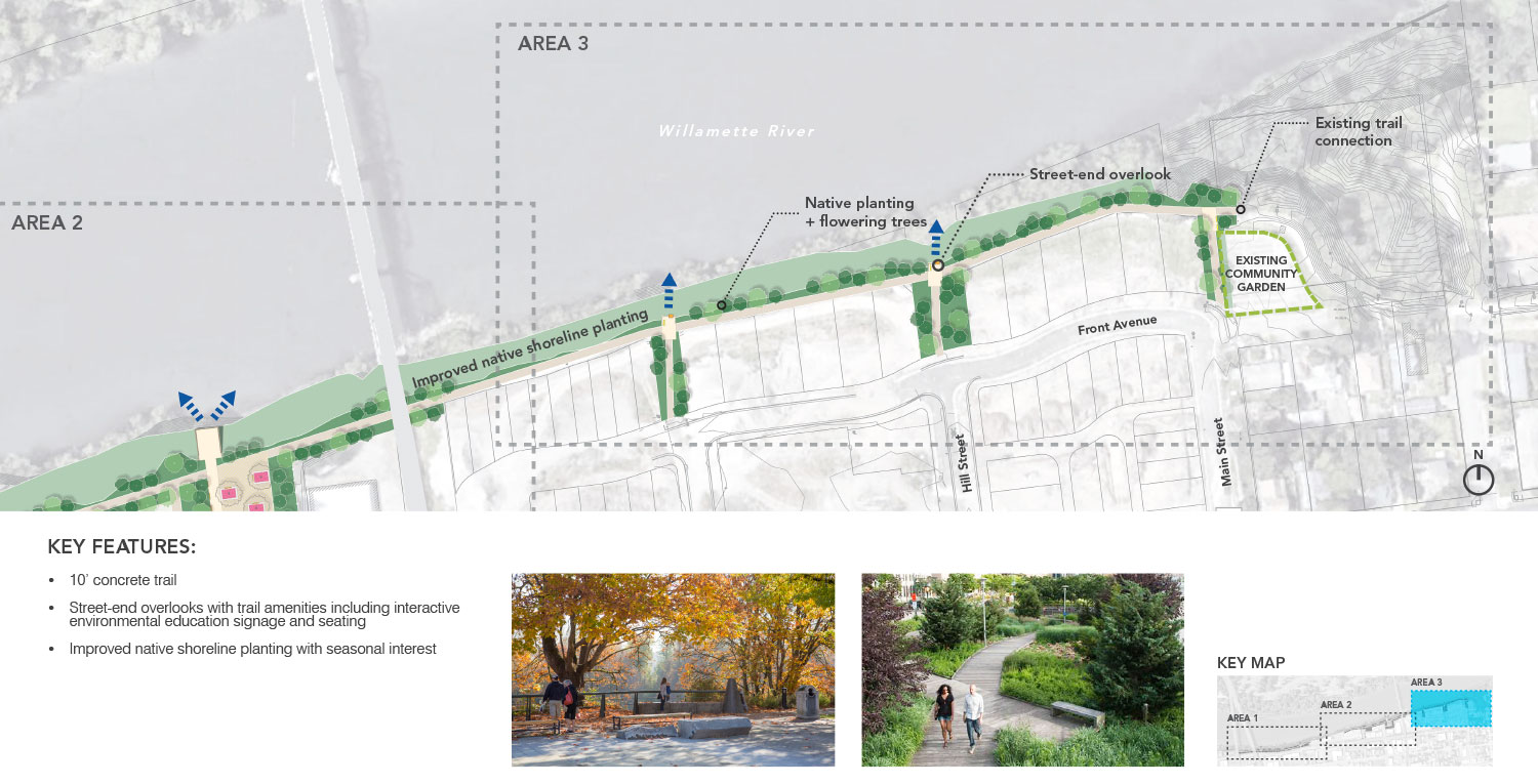
Area 3
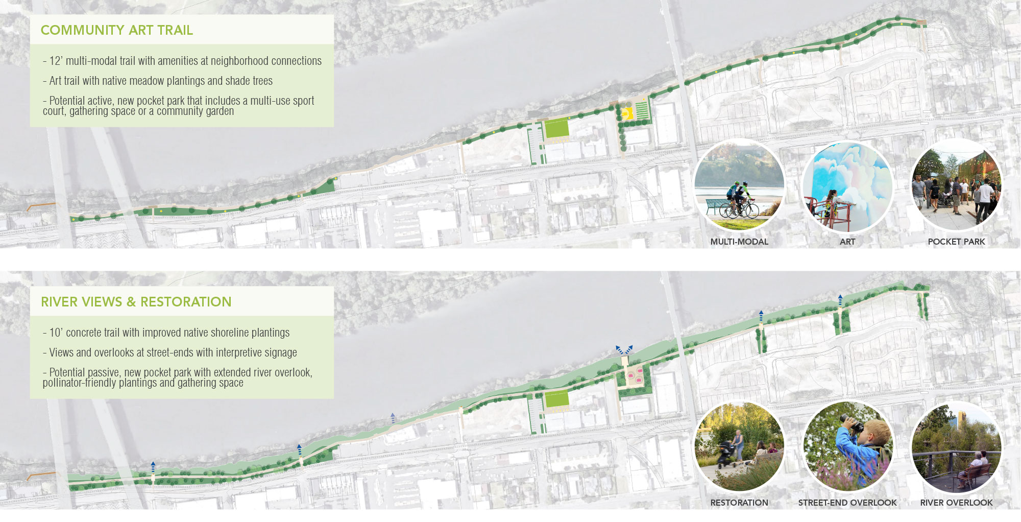
Albany has strong community ties to the arts and craftsmanship. Your talents have created a must-see destination at the carousel, and we believe that the Dave Clark Trail could be another opportunity to display and honor the talents you possess, offering up new ways to display and enjoy art in its many forms along the trail.
This concept proposes an upgraded, widened, multi-modal promenade that focuses on an active, cultural waterfront. A new alignment will gently weave back and forth along the waterfront edge, creating spaces for art, native meadows, shade trees, and park spaces with opportunities for integrating different art elements such as sculptures, installations, and murals.
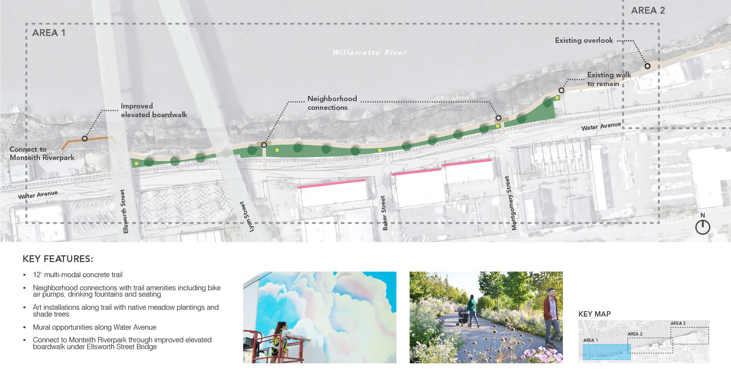
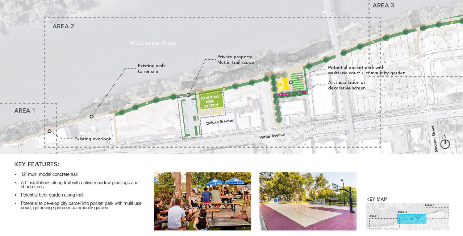
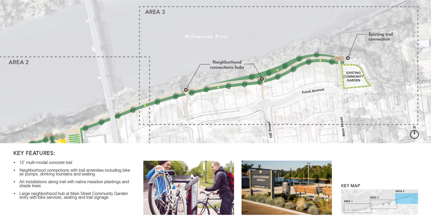
New north/south connections will be developed with improved railroad crossings at Water Avenue and direction connections to the trail. At the end of each of these connections, a “community hub” is imagined that could be a place for amenities such as bike repair stations, seating areas, art, and interpretation.
Key Features
- New 12’ wide multi modal path, weaving back and forth along the river.
- Plantings will focus on native meadows and shade trees.
- North/South connector paths every 1 to 3 blocks extending from the city’s street grid to the trail.
- Refurbishment of the existing elevated boardwalk.
- Suggested locations for sculptural and mural art that can be enjoyed from the trail and from Water Avenue.
- New lighting along the length of the trail.
- Community hub plazas with seating and bike amenities.
- A new pocket park that could be activated by a multi-use sport court, gathering space, or a community garden.
Questions


(Click images to enlarge.)

Area 1

Area 2
Area 3
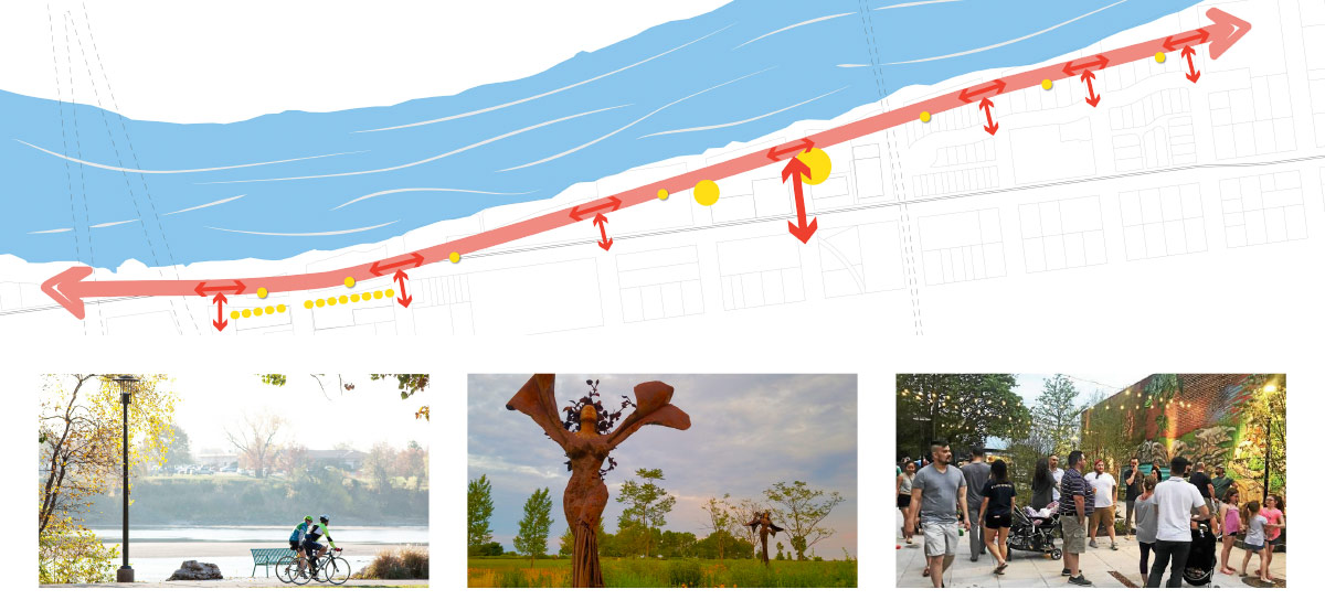
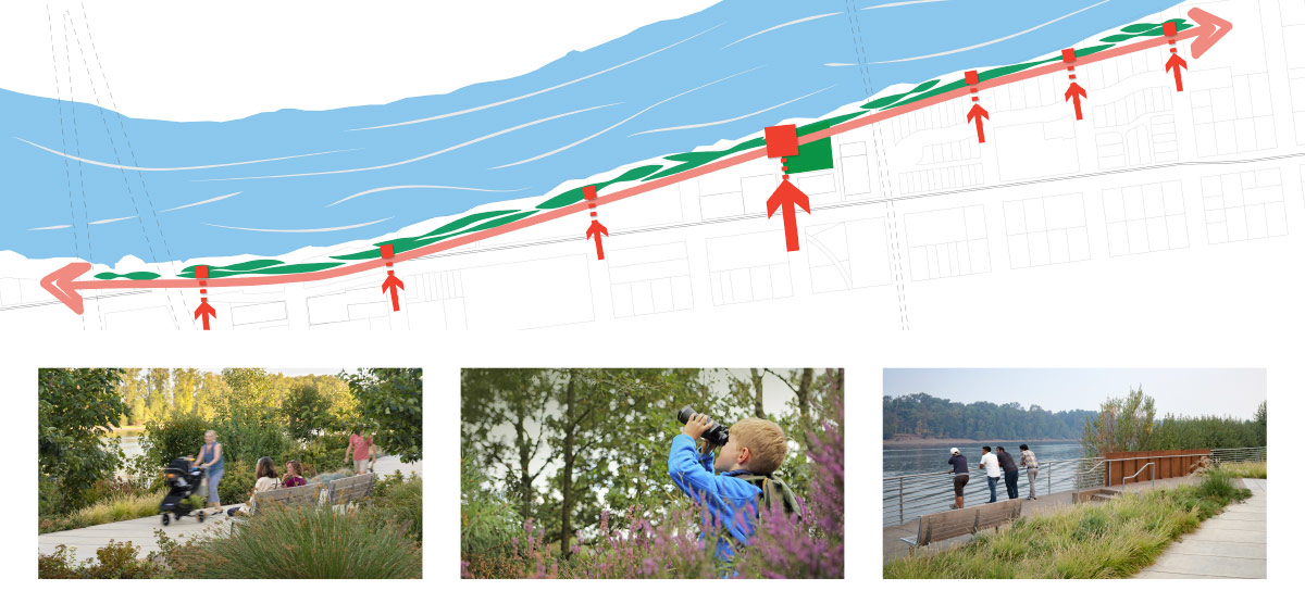
The Willamette River winds its way through the Willamette Valley, connecting cities along its beautiful shore. The focus of this concept is to emphasize this connection between the city and river. Through new plantings, street-end viewpoints, and improved trail alignments, community members can feel immersed in the natural beauty and wildlife of the Willamette, just steps from the urban downtown edge.
A more modest path width of 10’ is proposed, with naturalized plantings extending to the top of the river slope. This concept will include many opportunities for seating and enjoying the views, as well as integrated interpretive signs that offer more information about local ecology or history. Connections from side streets that intersect with Water Avenue will extend from the city grid to small overlooks that get people closer to the water.
Key Features
- New 10’ wide multi modal path, weaving back and forth along the river.
- A continuous edge of improved native shoreline planting.
- North/South connector paths every 1 to 3 blocks extending from the city’s street grid and extending past the trail to create overlooks at the river.
- Refurbishment of the existing elevated boardwalk.
- Interpretive moments can be incorporated at the overlooks and along the edge of the path.
- New lighting along the length of the trail.
- A new passive pocket park may include opportunities for gathering, relaxing, education and pollinator-friendly plantings.
Questions
Dave Clark Trail Concept Comparison


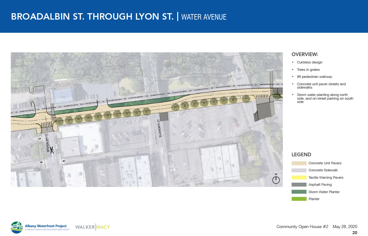
Water Avene Concept

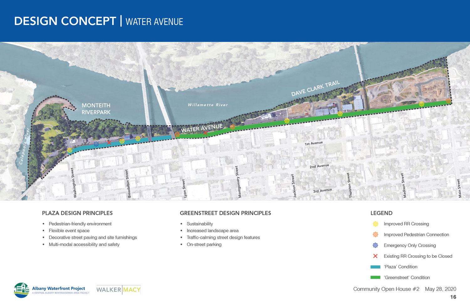
Approach
The team’s approach is guided by the 2009 plan with the intent of creating a more pedestrian friendly street condition with sidewalks and plantings that will improve the experience of walking on Water Avenue. Traffic speeds are a concern on Water Avenue, so the street has been designed with traffic calming devices including curbless streets and raised intersections that prioritize pedestrian accessibility.
The proposed design for Water Avenue is divided into two parts: a Plaza Street and a Greenstreet.
Review the images below and then answer the questions.


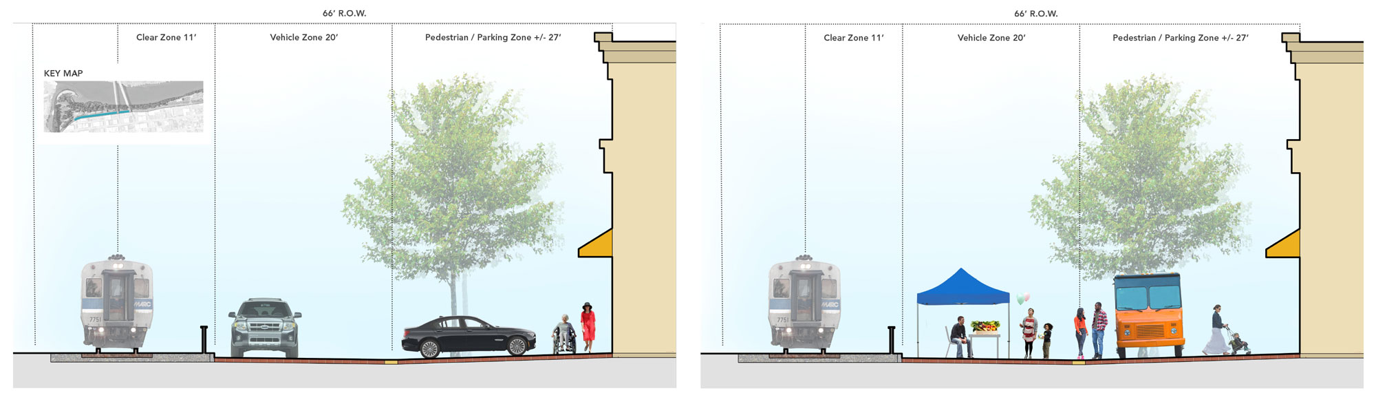


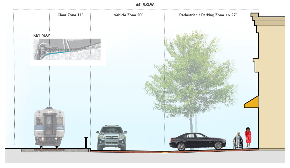
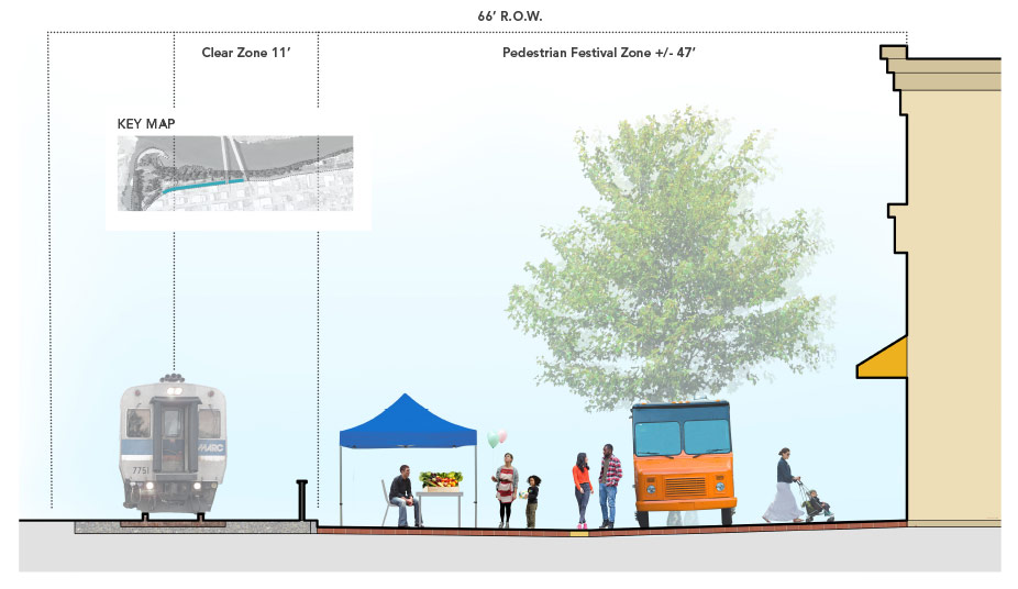
The Plaza Street is a curbless street that uses bollards and tactile paving to separate pedestrians from vehicles. This approach allows the street to be easily closed for larger events, and the full space will serve as a plaza area for events. The street and sidewalks will be unit pavers, creating a higher quality of finish than a typical street. Street trees in tree grates, lighting to match the downtown and stormwater planters will further add to the positive downtown feel and integrate Water into the downtown streetscape design.
Typical Plaza Street Section
(Click to enlarge.)
Plaza Street During an Event
(Click to enlarge.)
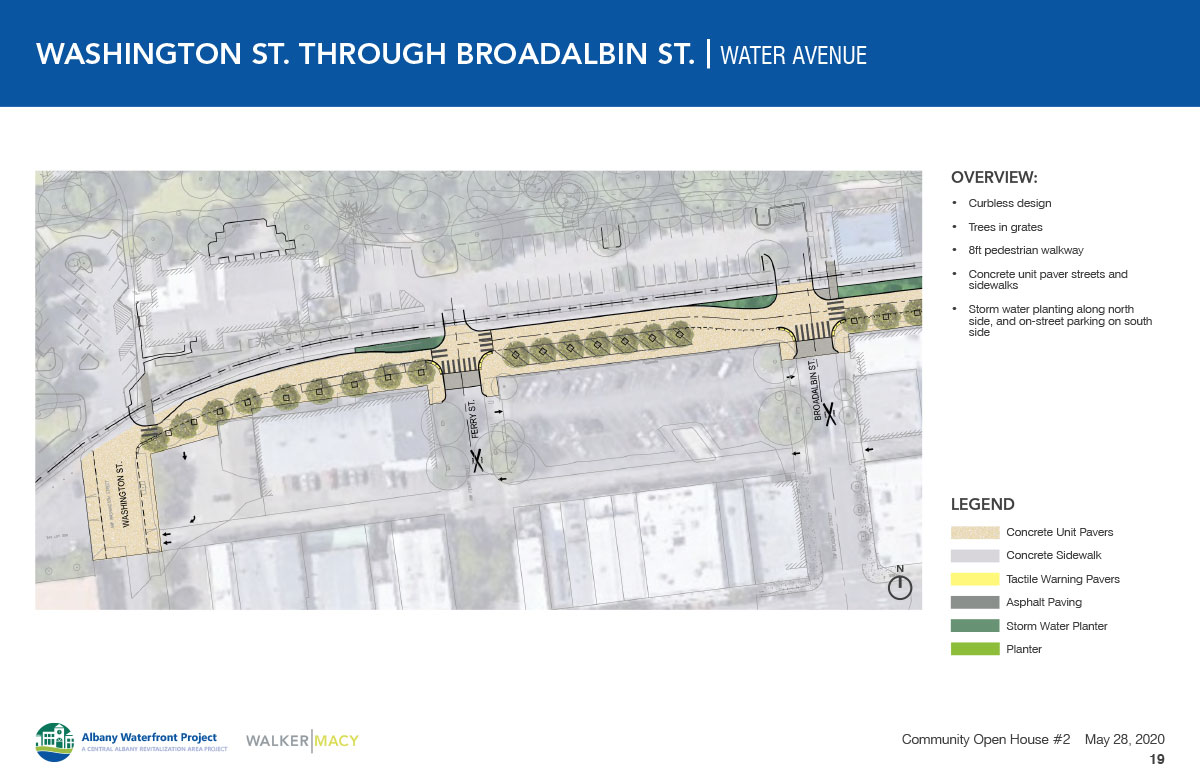
Washington to Broadalbin
- Curbless street with unit pavers for paving
- Bollards and tactile warning to separate pedestrian and vehicular zones
- Street trees in tree grates on the south side of Water Ave.
- Stormwater planters on the north side of Water Ave.
- On-street parking on the south side of the street
- Washington to Ferry is one-way heading east
- Ferry to Broadalbin is two-way traffic
- New railroad crossings for vehicles and pedestrians will be provided at Washington and Broadalbin
- The railroad crossing at Ferry will be for emergency vehicles only
Broadalbin to Lyon
- Curbless street with unit pavers for paving
- Bollards and tactile warning to separate pedestrian and vehicular zones
- Street trees in tree grates on the south side of Water Ave.
- Stormwater planters on the north side of Water Ave.
- On-street parking on the south side of the street between Ellsworth and Lyon
- Two-way vehicular traffic
- New railroad crossings for vehicles and pedestrians will be provided at Broadalbin
- The mid-block access between Broadalbin and Ellsworth will be retained


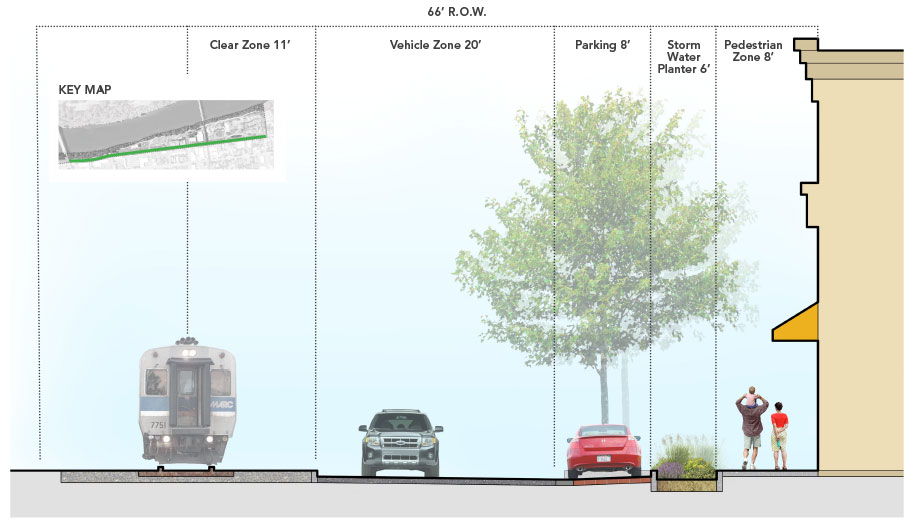


Curbs will separate concrete pedestrian sidewalks from asphalt vehicular zones. Parking areas may include pervious pavement and intersections will be raised and built with unit pavers to improve pedestrian safety and provide traffic calming. Paving street trees, planters lighting and other street furnishings will provide continuity with the downtown streetscape design.
Green Street Section

(Click to enlarge.)
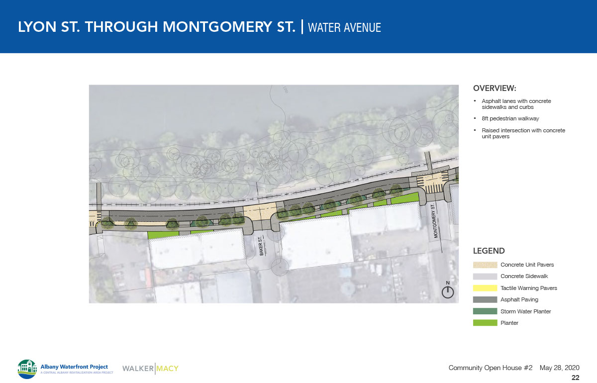
Lyon to Montgomery
- 8’ sidewalks with street trees in stormwater planters
- On-street parking on the south side of the street from Lyon to Baker
- Two-way vehicular traffic
- Raised intersections at Lyon, Baker and Montgomery
- New pedestrian railroad crossings at Lyon and Montgomery
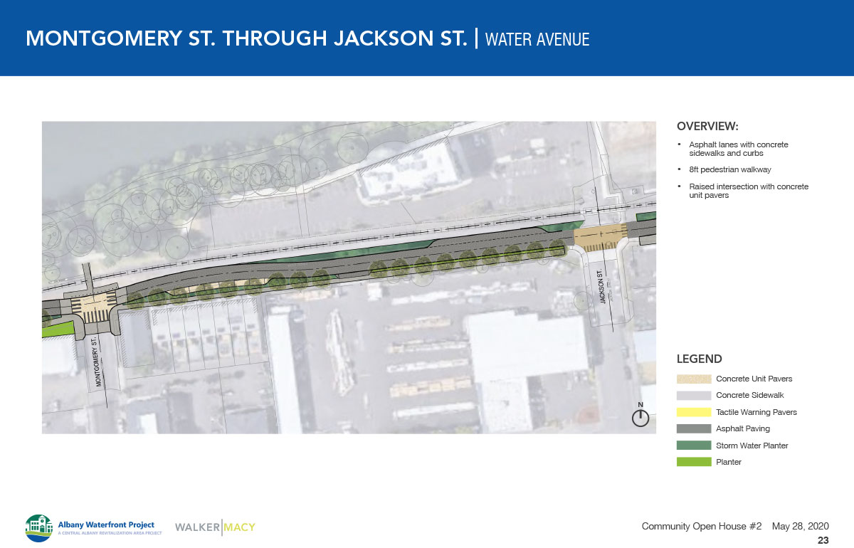
Montgomery to Jackson
- 8’ sidewalks with street trees in planters
- Stormwater planters on the north side of the street
- Limited on-street parking on the south side of the street
- Loading zone for temporary waiting on the north side of the street near Jackson
- Two-way vehicular traffic
- Raised intersections at Montgomery and Jackson
- New pedestrian railroad crossings at Montgomery

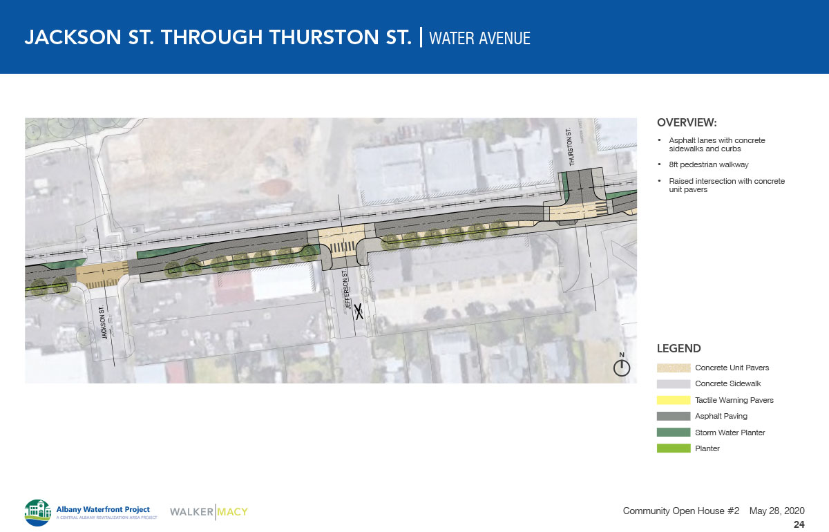
Jackson to Thurston
- 8’ sidewalks with street trees in planters.
- Limited stormwater planters on the north side of the street.
- On-street parking on the south side of the street.
- Two-way vehicular traffic.
- Raised intersections at Jackson, Jefferson and Thurston.
- New pedestrian and vehicular railroad crossings at Thurston
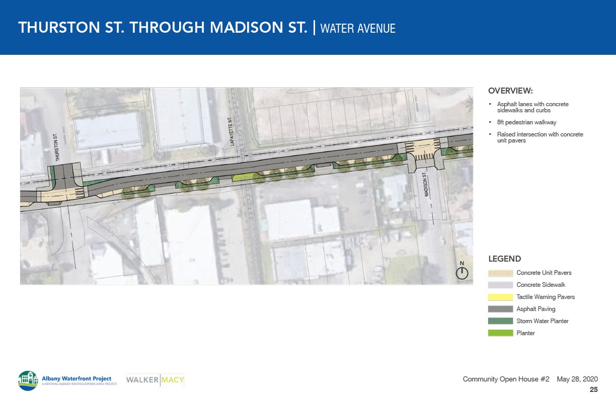
Thurston to Madison
- 8’ sidewalks with street trees in stormwater planters
- Limited stormwater planters on the north side of the street
- On-street parking on the south side of the street
- Two-way vehicular traffic
- Raised intersections at Thurston and Madison
- New pedestrian and vehicular railroad crossings at Thurston
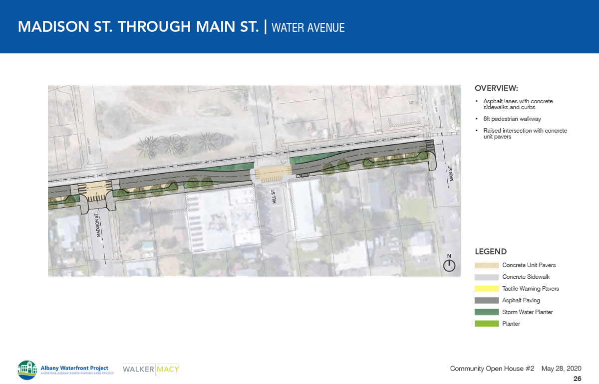
Madison to Main
- 8’ sidewalks with street trees in stormwater planters
- Limited stormwater planters on the north side of the street
- On-street parking on the south side of the street
- Two-way vehicular traffic
- Raised intersections at Madison, Hill and Main
- Existing pedestrian and vehicular railroad crossing at Main
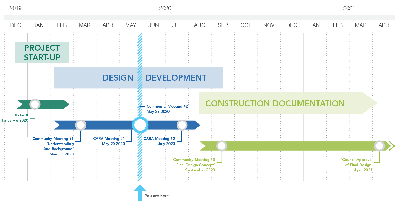
Schedule


Schedule
Your feedback will help the project team to create a new waterfront design that combines the best features from the concepts you learned about today. We hope to share the draft final design later this summer. The final plan is expected to be approved by City Council this fall.
A phased approach to construction will allow individual projects to be built over time. Pending final review, approval, and permitting, construction of individual projects could begin as early as fall/winter 2021.
Stay Involved
Provide your email below and consider sharing optional information about yourself so that we know who we are hearing from. We’ll add you to our email list and can keep you informed of the next opportunity to provide input on the project.
- Visit the project website for more information and to sign up for project updates: albanywaterfront.net
- Send questions to info@albanywaterfront.net
Final Questions
Tell us about yourself
 (Check one.)
Demographics (Optional)
The following questions help us know if we are reaching a representative cross-section of the community. They are completely optional.
