
View the information on this site using the buttons below or click "Get Started" above to move through the content in order.

= Page includes questions or opportunities for comment.
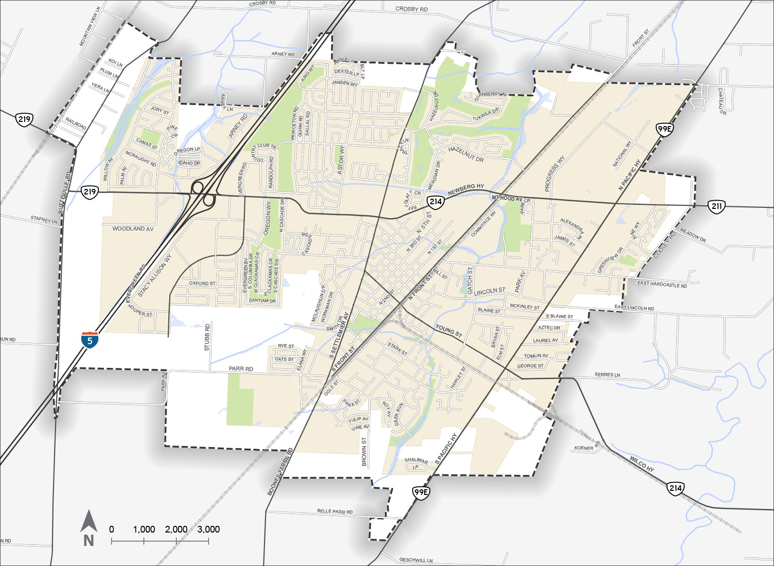
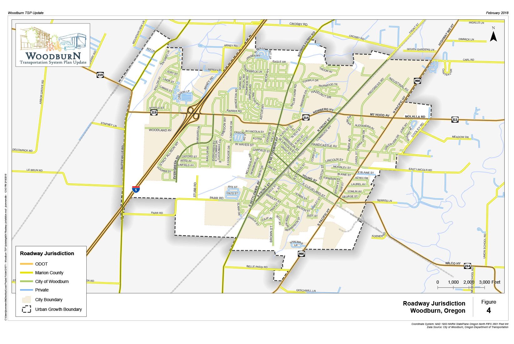
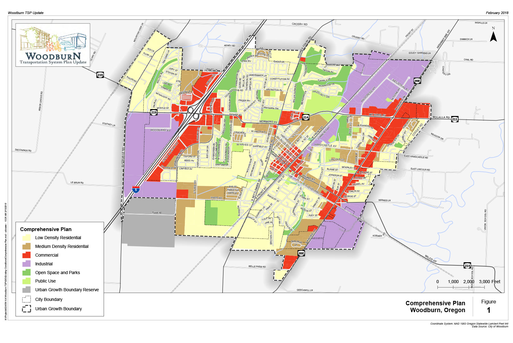
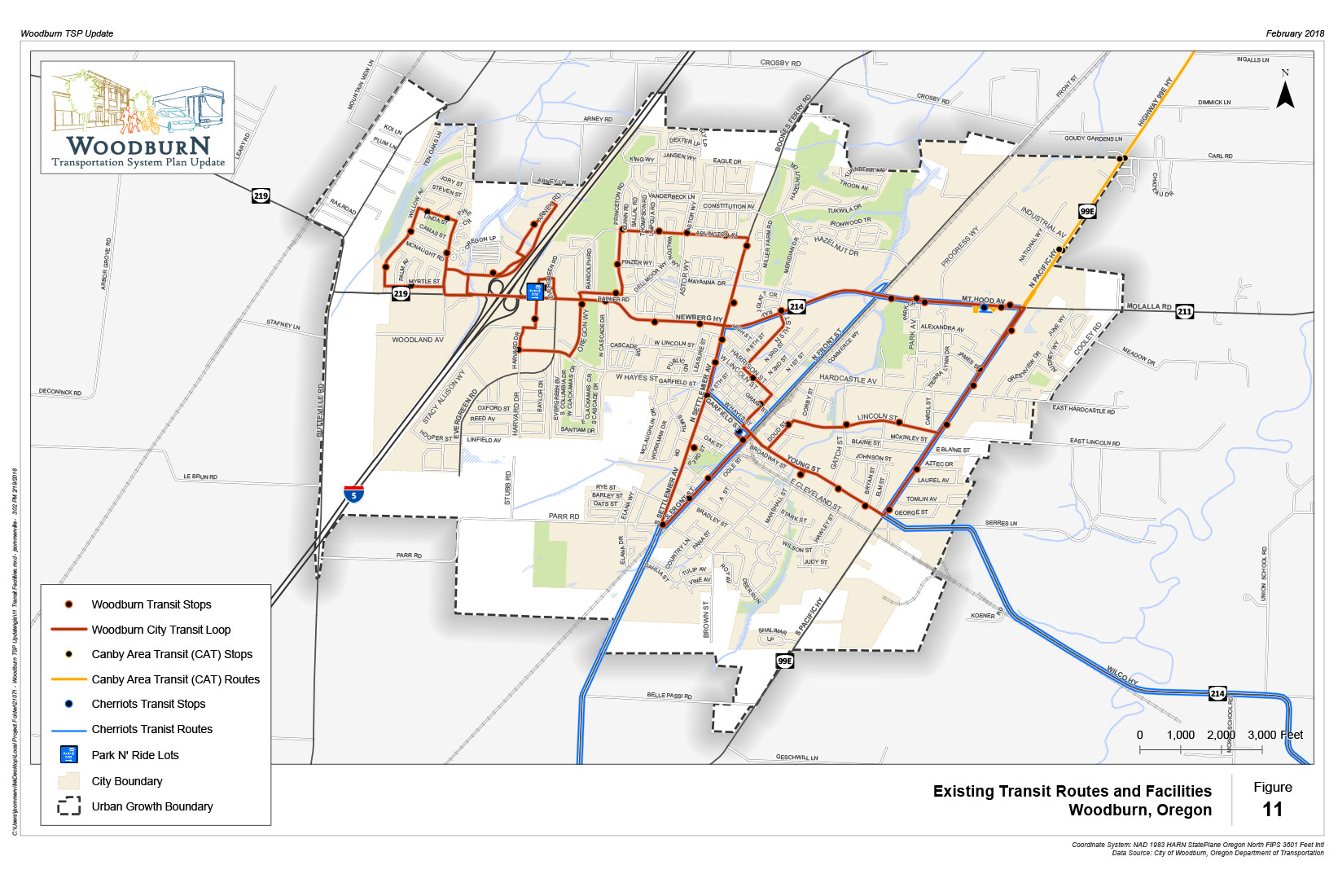
Woodburn City Limits and Urban Growth Boundary


Why update the plan?
The City’s existing Transportation System Plan was adopted in 2005. It needs to be updated to reflect the transportation needs of our community today and into the future.
In 2016, 619 acres were added to Woodburn’s Urban Growth Boundary (UGB). It will be important for the updated plan to consider our expanding community and changing transportation patterns.
Project Outcomes
What will the plan do?
- Develop an updated TSP that provides a safe, efficient, and well-connected transportation network for all transportation modes (biking, walking, rolling, motor vehicles, rail, transit, truck freight) based on existing and planned land uses.
- Identify transportation projects, policies and programs that will accommodate Woodburn’s population over the next 20 years, including opportunities to provide transportation facilities and services to the expanded Urban Growth Boundary areas and new urban reserve areas.
- Determine funding opportunities for new and future transportation projects.
- Update the existing project list to meet current and future transportation needs.
- Build on existing adopted plans and planning efforts.
- Identify strategies to create safe environments for children walking and biking to school, such as the Oregon Safe Routes to School Program.


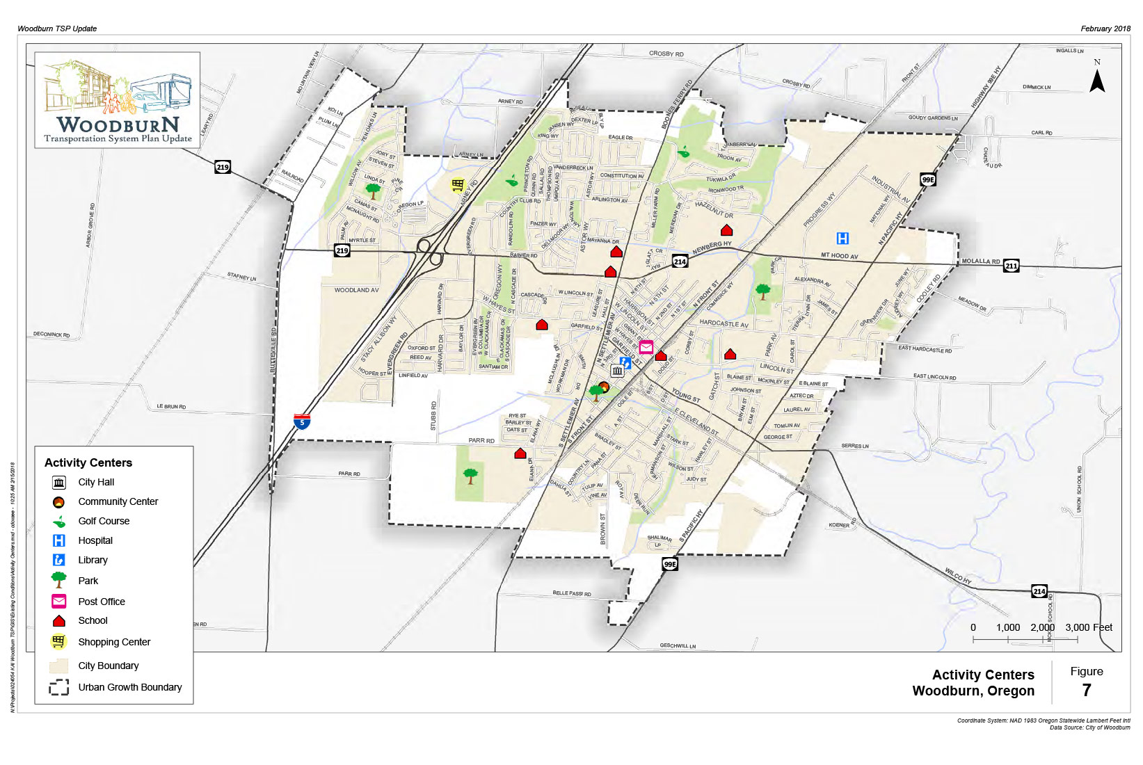

Existing Pedestrian Facilities

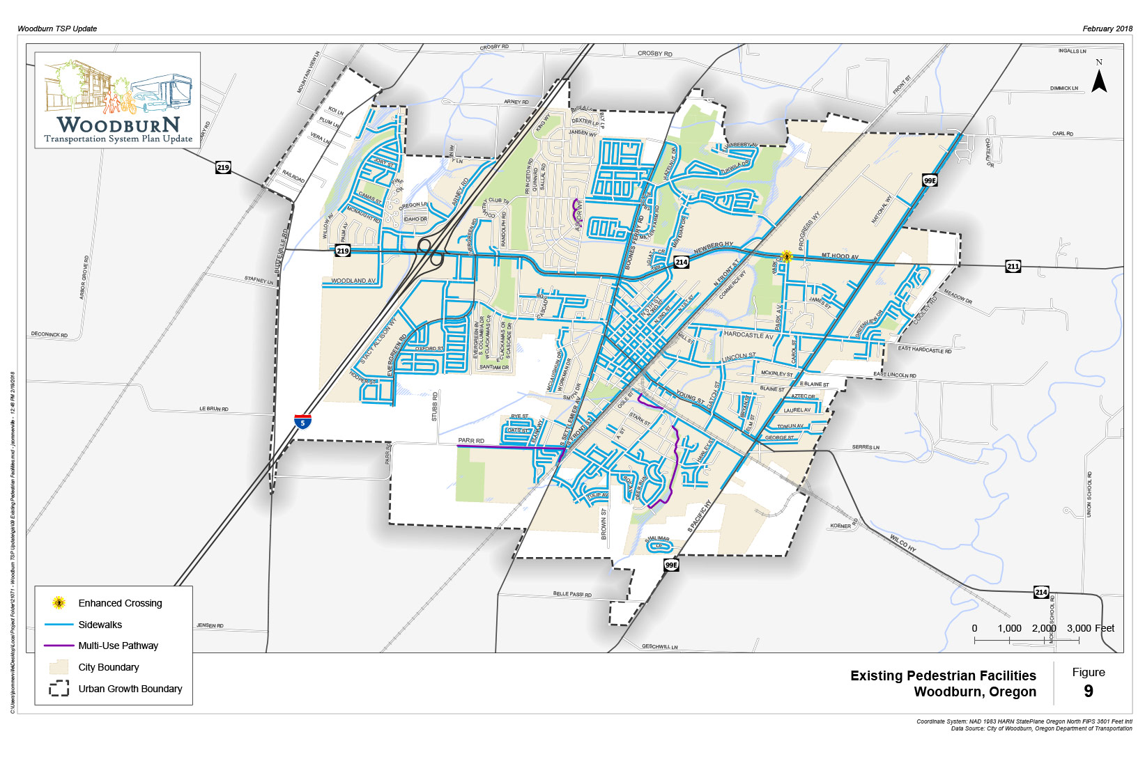
How would you rate the on-street walking/rolling network (such as sidewalks and roadway crossings) in Woodburn?
(Check one.)How would you rate off-street walking network (such as multi-use paths and trails) in Woodburn?
(Check one.)What are the main barriers to walking in Woodburn?
(Check all that apply.)Existing Bicycle Facilities

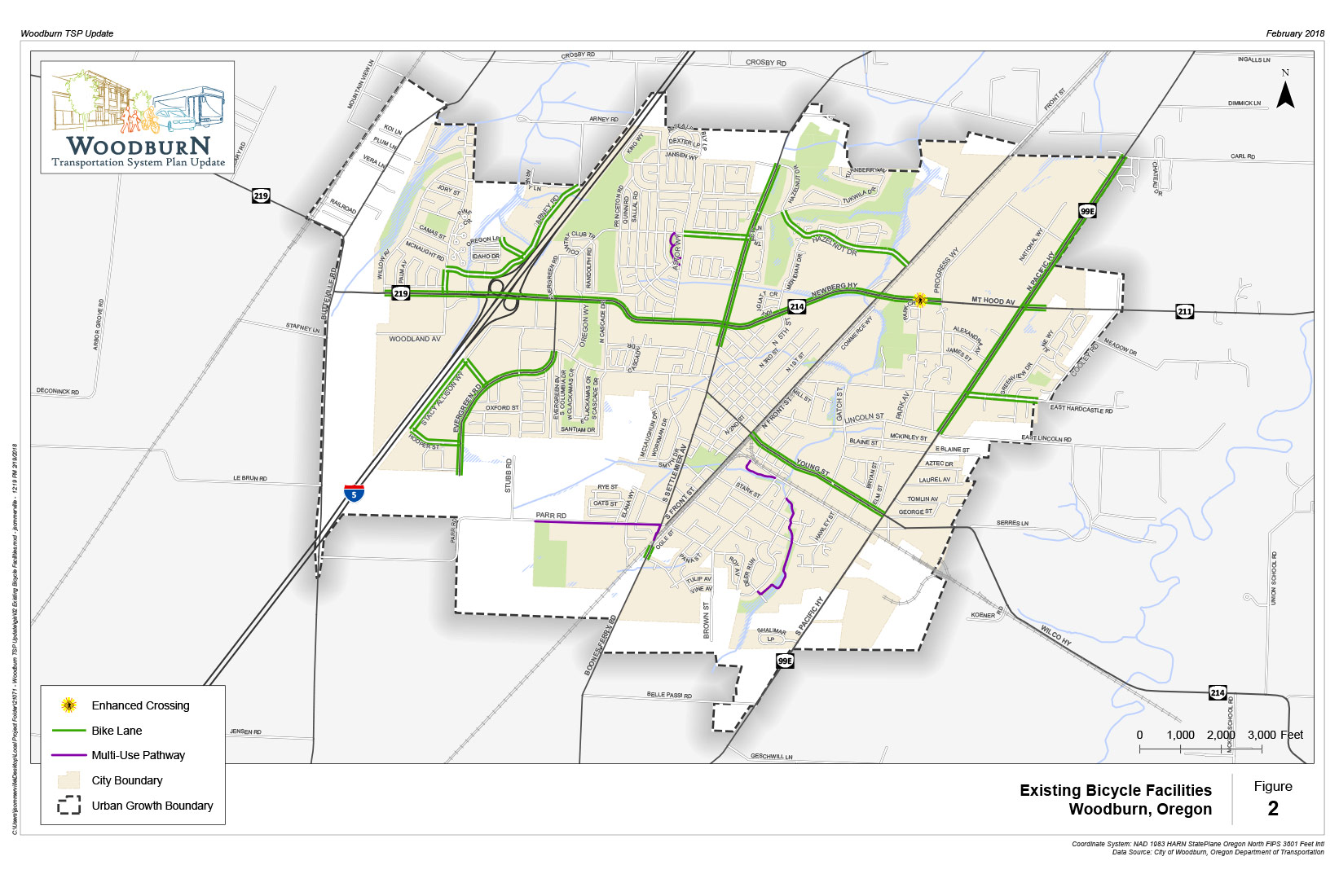
How would you rate the on-street bicycling system (such as bike lanes and bike parking) in Woodburn?
(Check one.)How would you rate the off-street bicycling system (such as multi-use paths and trails) in Woodburn?
(Check one.)What are the main barriers to bicycling in Woodburn?
(Check all that apply.)
Comment Wall Answer
characters remaining.
Read other comments...


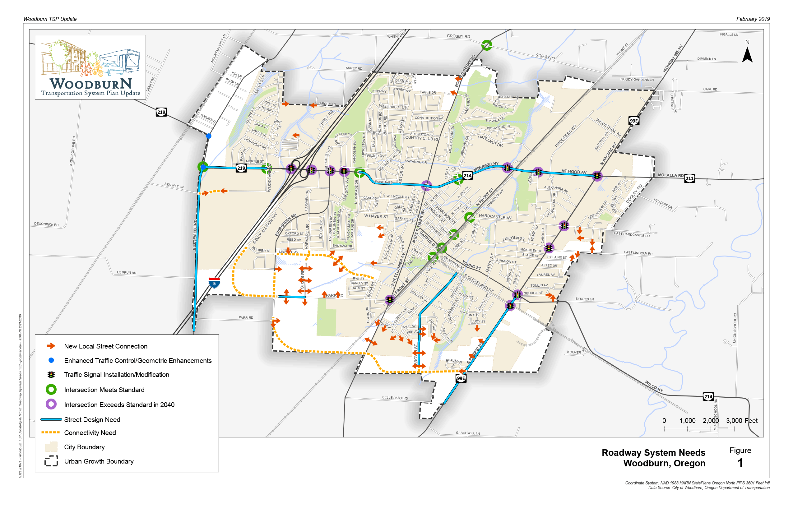
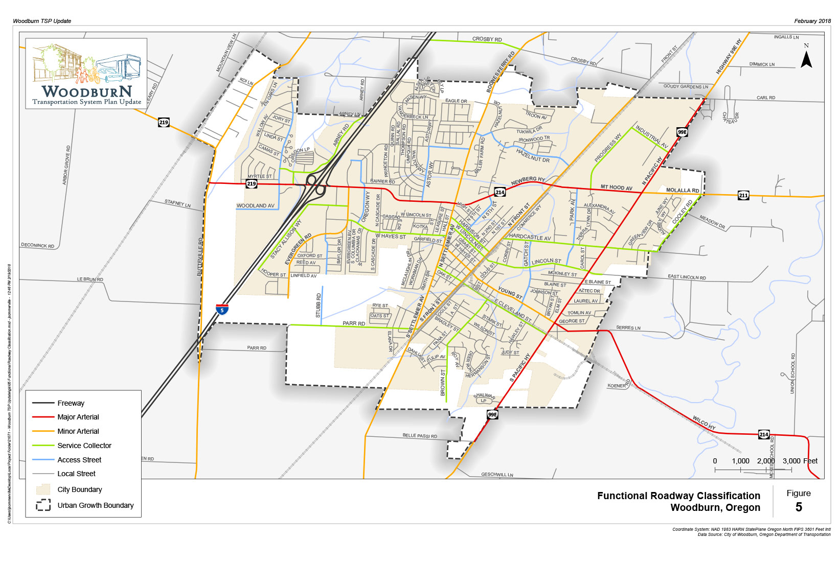
Potential Projects
Environmental Impact Engineering Challenge Consistency with Land Use
Relative Cost Preliminary Preferred Solution
Street Connectivity Improvements | ||||||
| South Arterial | Construct the Southern Arterial from Evergreen Road to OR 99E (2 lanes) | !EIY | !ECY | !LUY | $$$ | !X |
| Evergreen Road | Extend south to Parr Road | !EIY | !ECY | !LUY | $$ | !X |
| Stacy Allison Drive | Extend south to Parr Road | !EIY | !ECY | !LUY | $$$ | !X |
| Brown Street | Extend south to the South Arterial | !EIY | !ECY | !LUY | $$ | !X |
| Woodland Avenue | Extend west to Butteville Road through future development | !EIY | !ECY | !LUY | $$ | !X |
| Ben Brown Lane from Settlemier Avenue to Elans Way | Re-designate Ben Brown Lane as an Access Street | !EIN | !ECN | !LUN | $ | !X |
| Ben Brown Lane | Extend Ben Brown Lane to Evergreen Road as an Access Street as part of future residential development | !EIY | !ECY | !LUY | $$ | !X |
Capacity-based Improvements | ||||||
| OR 219 from Butteville Road to Woodland Avenue | Widen roadway to include two lanes in each direction and a two-way left-turn lane | !EIY | !ECY | !LUY | $$ | !X |
| OR 214 from Cascade Drive to OR 99E | Widen roadway to include two lanes in each direction and a two-way left-turn lane | !EIY | !ECY | !LUY | $$$ | !X |
| OR 99E from Young Street to south UGB | Widen roadway to provide a continuous two-way left-turn lane and wider shoulders (in conjunction with pedestrian and bicycle facility improvements) | !EIY | !ECY | !LUY | $$ | !X |
| Parr Road | Upgrade to service collector urban standards | !EIY | !ECY | !LUY | $$ | !X |
| Butteville Road, south of OR 219 | Upgrade to minor arterial urban standards | !EIY | !ECY | !LUY | $$$ | !X |
| Brown Street | Upgrade to service collector urban standards | !EIY | !ECY | !LUY | $$ | !X |
| OR 214/I-5 Southbound Ramp Intersection | Signal retiming | !EIN | !ECY | !LUN | $ | !X |
| Establish alternative mobility standards | !EIN | !ECN | !LUN | $ | ||
| OR 214/I-5 Northbound Ramp Intersection | Signal retiming | !EIN | !ECY | !LUN | $ | !X |
| Establish alternative mobility standards | !EIN | !ECN | !LUN | $ | !X | |
| OR 214/Evergreen Road Intersection | Signal retiming | !EIN | !ECY | !LUN | $ | !X |
| OR 214/Oregon Way/Country Club Road Intersection | Signal retiming | !EIN | !ECY | !LUN | $ | !X |
| OR 214/Front Street Ramp Intersection | Install a traffic signal | !EIY | !ECY | !LUY | $$ | !X |
| OR 214/Park Street Intersection | Install a traffic signal | !EIY | !ECY | !LUY | $$ | !X |
| OR 214/OR 211/OR 99E Intersection | Reconfigure southbound approach to have two turn-lanes and the east leg to have two receiving lanes, including signal retiming | !EIY | !ECY | !LUY | $$ | !X |
| Parr Road/Settlemier Avenue Intersection | Install a traffic signal | !EIY | !ECY | !LUY | $$ | !X |
| OR 99E/Hardcastle Avenue Intersection | Reconfigure the westbound approach to incorporate one left-turn lane and one thru-right turn lane | !EIY | !ECY | !LUY | $$ | !X |
| Reconfigure the westbound approach to incorporate one left-turn lane and one thru-right turn lane and install a separate right-turn lane on the southbound approach, including signal retiming | !EIY | !ECY | !LUY | $$ | ||
| OR 99E/Lincoln Street Intersection | Reconfigure the eastbound approach to incorporate one left-turn lane and one thru-right turn lane | !EIY | !ECY | !LUY | $$ | !X |
| Reconfigure the eastbound approach to incorporate one left-turn lane and one thru-right turn lane and install a separate right-turn lane on the southbound approach, including signal retiming | !EIY | !ECY | !LUY | $$ | ||
| OR 99E/Young Street Intersection | Install a third westbound lane to provide separate left, thru, and right turn lanes. Implement protected-permissive left-turn phasing on the eastbound and westbound approaches. | !EIY | !ECY | !LUY | $ | !X |
| OR 99E/Cleveland Street Intersection | Install a traffic signal, including OR 99E coordination | !EIN | !ECY | !LUY | $ | !X |
Safety Improvements | ||||||
| Butteville Road/Parr Road | Rebuild intersection due to grades on approaches | !EIY | !ECY | !LUY | $$ | !X |
| Southern OR 219/Butteville Road | Realign OR 219 to improve intersection(s) with Butteville Road | !EIY | !ECY | !LUY | $$ | !X |
| Enhanced traffic control (traffic signal, roundabout, or other appropriate geometric enhancements) | !EIY | !ECY | !LUY | $$ | !X | |
| Northern OR 214/Butteville Road Intersection | Enhanced traffic control (traffic signal, roundabout, or other appropriate geometric enhancements) | !EIY | !ECY | !LUY | $$ | !X |
| OR 99E | Update roadway lighting to meet ODOT roadway lighting standards | !EIY | !ECY | !LUY | $ | !X |
| OR 99E access between Young Street and Cleveland Street | Restrict certain turning movements | !EIN | !ECY | !LUY | $ | |
| Close street accesses and potential lot consolidation | !EIN | !ECY | !LUY | $$ | !X | |
| Front Street/Lincoln Street Intersection | Enhanced signs and pavement markings (e.g. stop signs, warning signs, and/or beacons) | !EIN | !ECN | !LUY | $ | !X |
| Front Street/Young Street/Garfield Street Intersection | Evaluate the intersection layout, signing, and striping in correlation to the railroad tracks. Provide clarification for westbound drivers trying to proceed through the intersection | !EIY | !ECY | !LUY | $ | !X |
| OR 99E/Tomlin Avenue | Restrict the southbound left-turn movement | !EIN | !ECN | !LUY | $ | |
| Evaluate the intersection layout, signing, and striping, including any sight distance constraints | !EIY | !ECY | !LUY | $ | !X | |
| City-wide | Evaluate traffic safety along OR 99E, OR 219/OR214, Front Street, Evergreen Road, and other key corridors to identify appropriate countermeasures | !EIN | !ECY | !LUY | $ | !X |
Questions
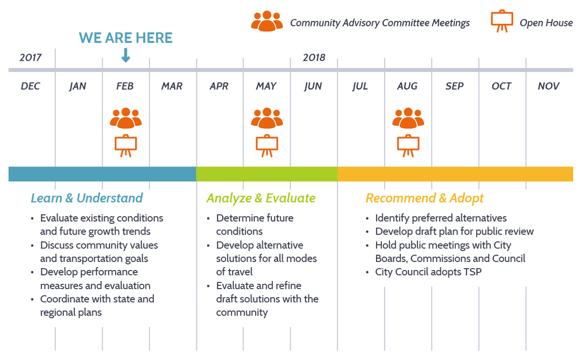
Project Schedule

Stay involved
- Learn more at WoodburnTSP.org
- Sign up for email updates below.
Final questions
Before you leave, be sure to submit any comments you've provided.
