The Transportation System Plan Update will revise local transportation planning goals, objectives and projects to reflect new growth and emissions control strategies identified in the 2035 Regional Transportation Plan (RTP). State law requires that local agencies bring their TSPs into compliance with the RTP.
This interactive tool includes a series of stations where you can learn more about the project. Thank you for participating.
Project Information
- Open House Handout (pdf, 1.2MB)
- Draft Documents and Meeting Packets (link)
Workshop Stations
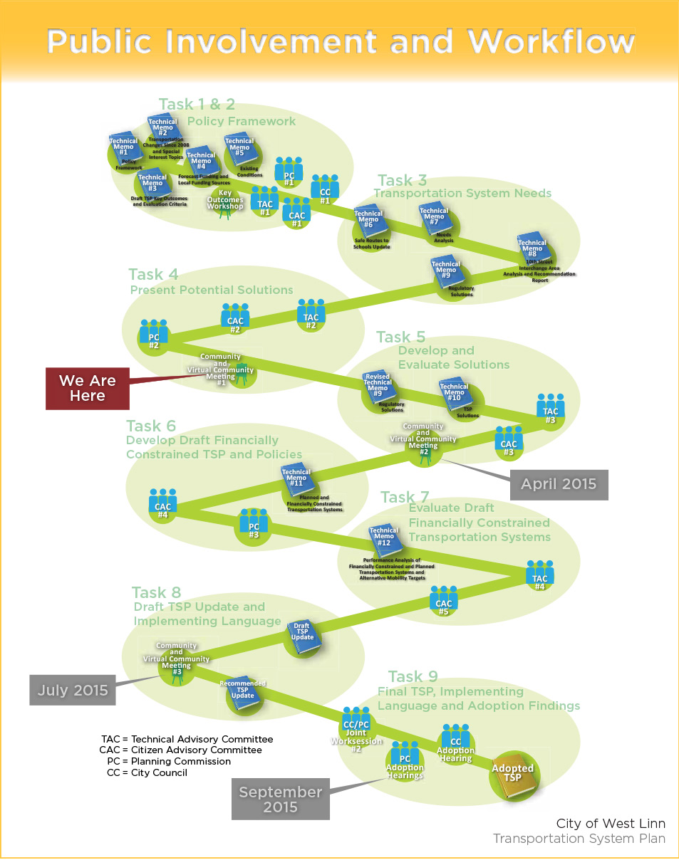
Public Involvement and Workflow


What is a Transportation System Plan?
A Transportation System Plan is a document that outlines projects, policies and strategies to improve the transportation system over the next 20 to 25 years. Projects, policies and strategies can include:
- Constructing new roads or modifying existing roads;
- Constructing new pedestrian and/or bicycle paths;
- Modifying transit service;
- Modifying roadway design standards;
- Modifying access standards; and,
- Identifying funding strategies to fund the transportation
- projects, operations and maintenance.
West Linn is required by law to create and update transportation system plans that are consistent with the Metro Transportation Plan and the State’s
Transportation Plans.
The most recent West Linn TSP was completed and adopted in 2008. The purpose of this project is to update that document with current analysis and ideas to solve existing and potential future transportation issues. A complete, up-to-date, and adopted TSP makes it easier for communities to compete and obtain funds and reserve right-of-way to implement the transportation projects needed to improve their system.
Project Background
Despite relatively low growth, much has changed since the last TSP Update in 2008. There have been significant changes in the regional transportation system and significant changes in the assumptions about future regional growth. Based on these changes, the following special interest topics, policy themes, and policy issues are being considered in the update of the TSP. You can learn more about each of these considerations in the project Technical Memos 1: TSP Policy Framework (pdf, 2.9MB), and 2: Transportation Changes Since 2008 (pdf, 1.0MB).
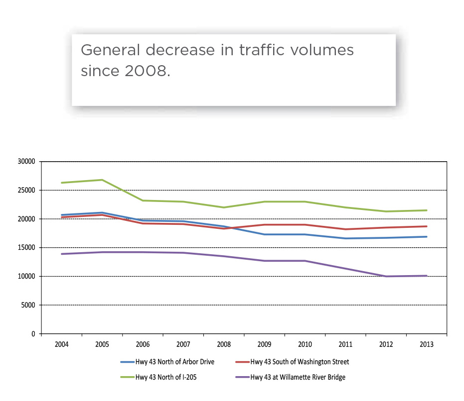
Transportation Changes since 2008
- Relatively little local land development
- Regional roadway construction projects (Sellwood bridge, Arch Bridge rehabilitation, Highway 213 jughandle)
- Incremental infill of sidewalks and bike lanes ongoing
Special Interest Topics
- Arch Bridge Town Center (addressed separately)
- Old Willamette Area parking management
- Decreasing the amount of people who commute alone
- Expanding transit supportive land uses
- New ways to measure our transportation system
West Linn policy themes
- Safety for all modes
- Increasing mobility through transit
- "Complete streets" (for walking, biking, and accessing transit, schools, parks, and commercial areas with direct routes)
- Ensuring I-205 functions well for West Linn citizens
- Limiting Highway 43 to two to three lanes (improvements for all modes but no more vehicle through lanes)
- Retain the existing UGB
TSP Policy Issues
- Current plan includes $40 million (+) new, I-205/10th Street interchange. Geography presents a constraint that a new interchange is unlikely to resolve or overcome.
- State forecast a significant revenue decline.
- City’s population density does not support transit expansion yet current policy suggests expanding transit is a solution to increase mobility.
- City opposes UGB expansion yet has limited supply of buildable land.
Key Outcomes and Evaluation Criteria
The TSP goals are based upon the city’s 2008 Imagine West Linn process, the Comprehensive Plan, and regional transportation goals. The evaluation criteria will be used to ensure that proposed set of projects will be effective in achieving the city’s goals. Read more about the project goals and evaluation criteria in Technical Memo 3: Performance Outcomes and Key Measures Workshop (pdf, 290KB).
Goal 1 - Safety: Reduce transportation related fatalities and injuries for all transportation modes +
Evaluation Criteria
- Would likely reduce severe injury and fatal crashes
- Would likely reduce the number of high collision locations
Goal 2 - Mobility, Access and Environment: Improve people’s access to jobs, schools, healthcare and other needs in ways that improve health, reduce pollution and retain money in the local economy +
Evaluation Criteria
- Would likely reduce VMT
- Supports a compact urban form and would likely increase non-SOV modes of travel in 2040 Regional Investment Centers
- Would result in improved freight travel time reliability
- Would allow more people to access schools, parks, and employment and commercial areas within 20 minute walk, bike or bus ride
- Relates to implementation of a transportation options program
- Would result in “good” or better level of quality bicycle or pedestrian facility
- Is a “green street” facility
Goal 3 - Equity: Deliver transportation improvements equitably +
Evaluation Criteria
- Would allow more people, considered transportation disadvantaged, to access schools, parks, and employment and commercial areas within 20 minute walk, bike, or bus ride
- Located in an area where transportation investments have not been made in past 10 years
Goal 4 - Maintenance:Deliver access and safety improvements cost effectively, within available revenues and responsibly to the needs of all users of the transportation system +
Evaluation Criteria
- Improves the pavement condition index
- Is an improvement to a facility that is considered “distressed”
- Supports a compact urban form and would likely increase non-SOV modes of travel in 2040 Regional Investment Centers
Project Team and Committees
Project Management Team +
- Transportation Planning & Engineering
- Kittelson & Associates, Inc.: Susan Wright and Matt Bell
- Code and Policy
- DJ Heffernan
- City of West Linn
- Community Development: Zach Pelz, John Boyd
- Engineering: Lance Calvert
- Oregon Department of Transportation
- Grant Manager: Gail Curtis
Technical Advisory Committee +
- Zach Pelz — City of West Linn
- John Boyd — City of West Linn
- Lance Calvert — City of West Linn
- Khoi Le — City of West Linn
- Gail Curtis — ODOT
- Susan Wright — Kittelson & Associates, Inc.
- Matt Bell — Kittelson & Associates, Inc.
- DJ Heffernan — DJ Heffernan
- Laura Terway — Oregon City
- Amanda Owings — Lake Oswego
- Larry Conrad — Clackamas County
- Chris Myers — Metro
- Tom Mills — TriMet
- Jennifer Donnelly — DLCD
Citizens Advisory Committee +
- Joyce Jackson
- Riad Alharithi
- Kim Bria
- Kris Kachirisky
- Dave Kleinke
- Kimberly Steele
- Craig Bell


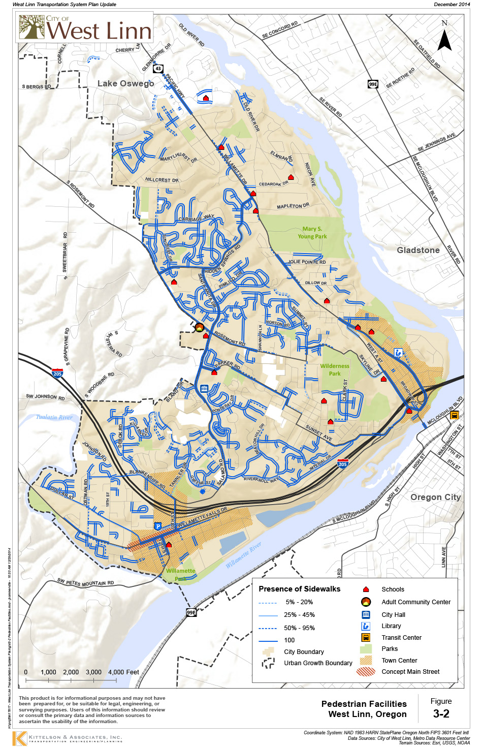
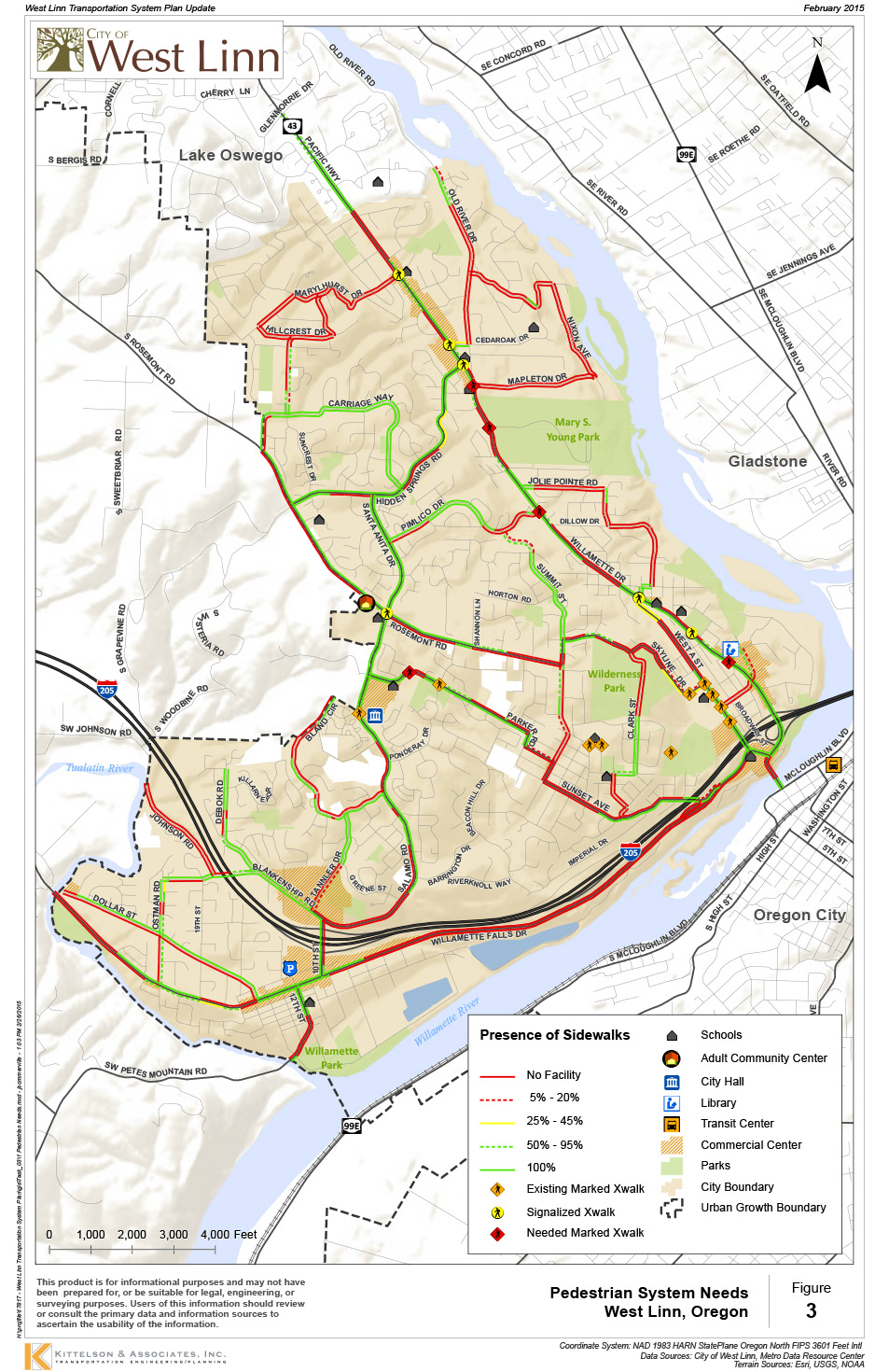
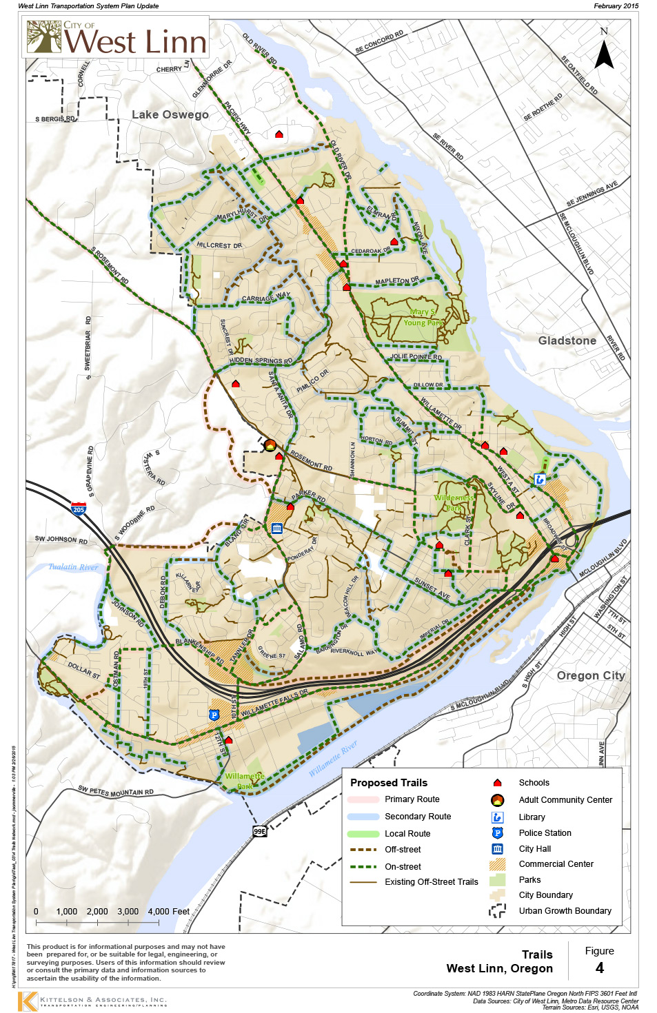
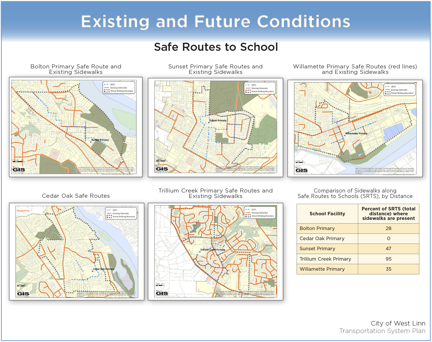
These are identified in the Pedestrian Facilities display. The Pedestrian Needs display identifies needs for crossings and where there is a lack of necessary sidewalks. The Trails display shows the City’s existing Trails Master Plan trails and on-street connections. The Safe Routes to School display identifies the routes and needs along the routes elementary schools have designated as safe routes for walking to school. Safe Routes to School an on-street connections to trails will have special consideration in prioritizing pedestrian improvements.
Read other comments...


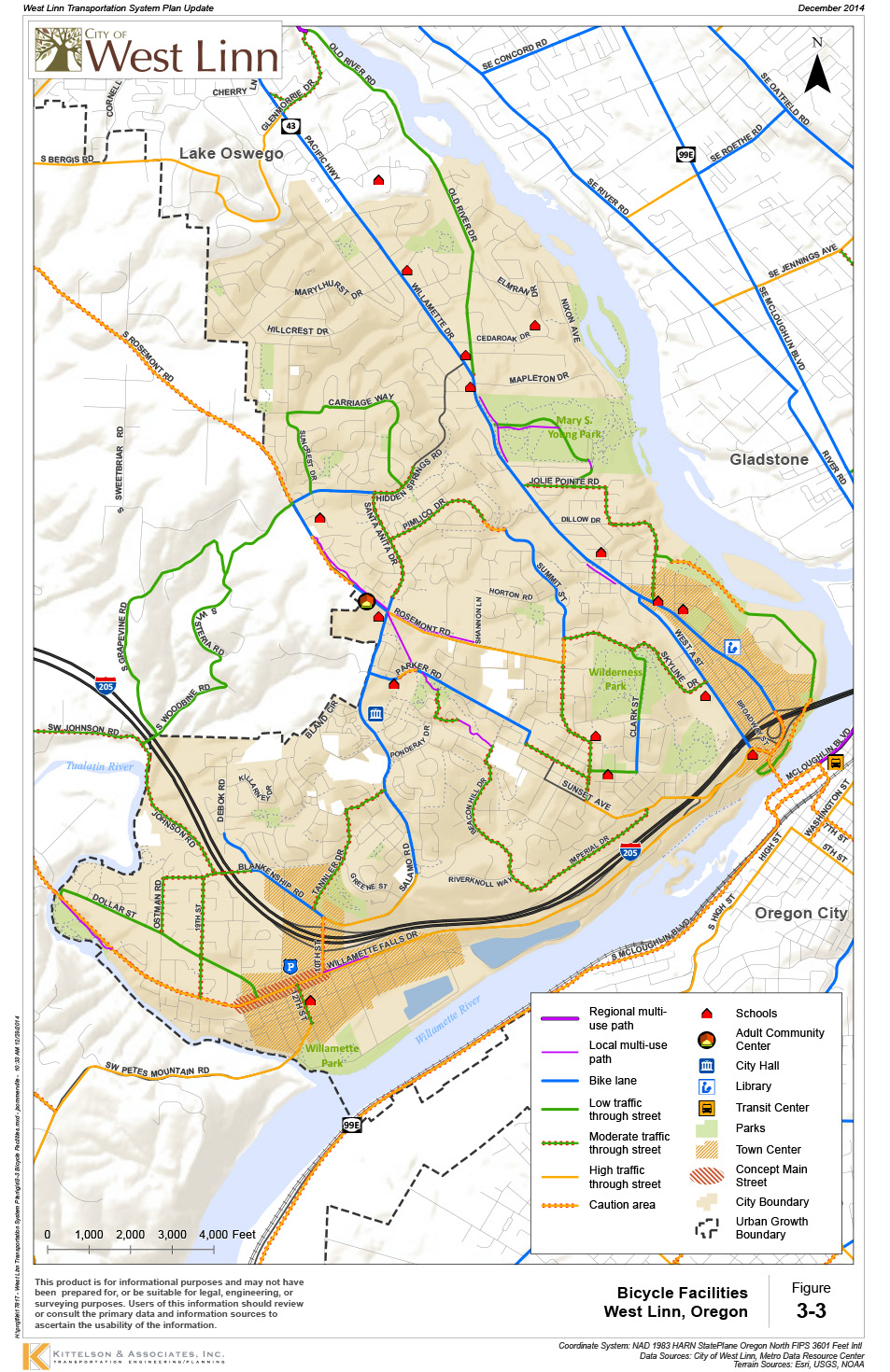
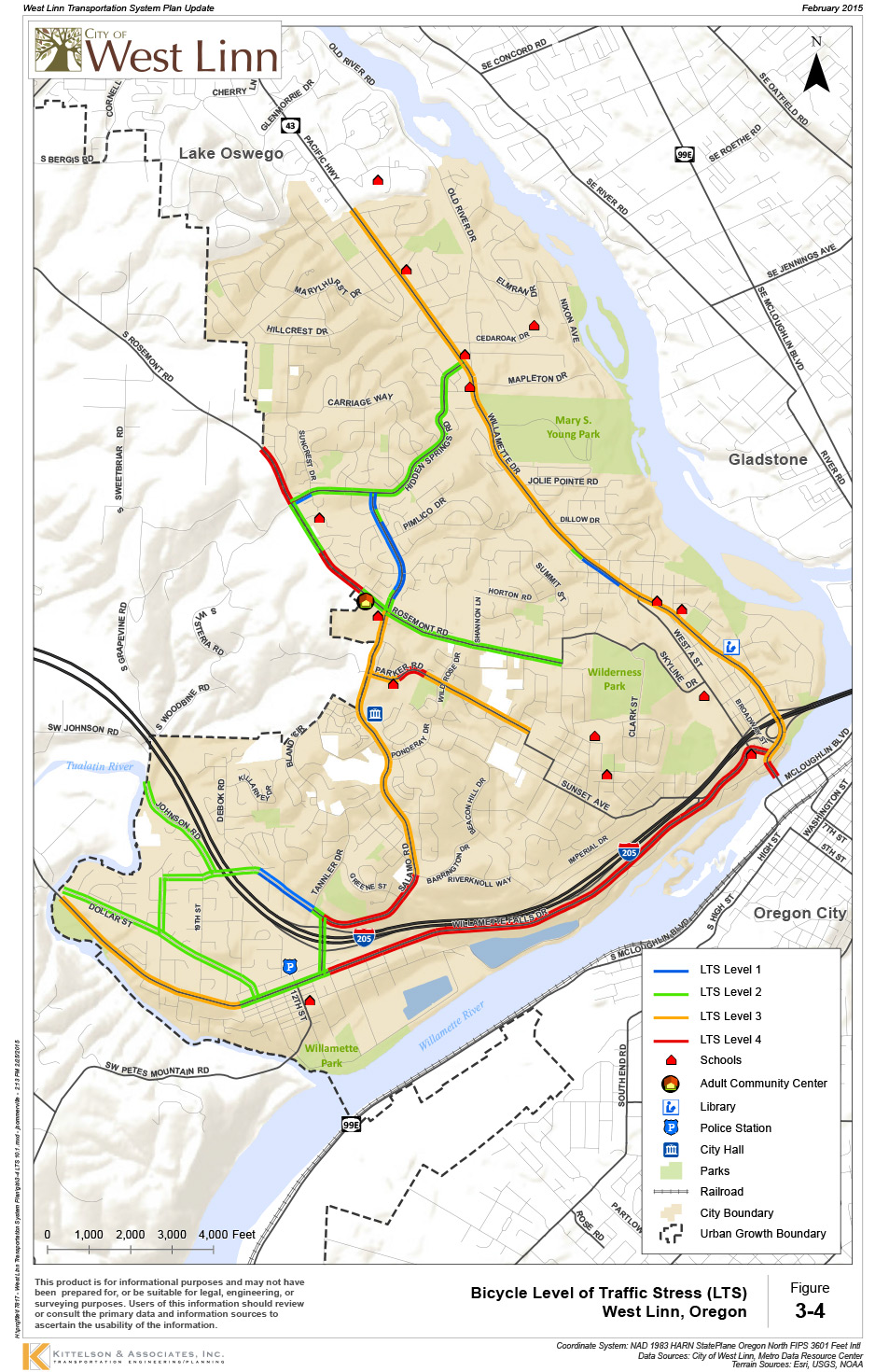
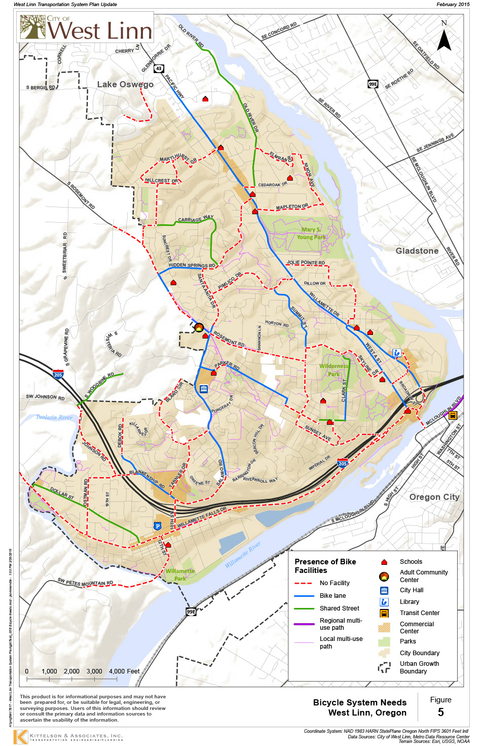
The Bicycle Facilities display identifies the on-street bike facilities. The Bicycle Needs display identifies areas where there is a lack of needed bike facilities. The Level of Traffic Stress display helps identify routes that are low stress (good for children) to medium stress (good for most adults), and high stress routes (which are not desirable routes for most adults). Connecting low-stress routes, trails, and Safe Routes to School will have special consideration in prioritizing bicycle improvements.
Read other comments...
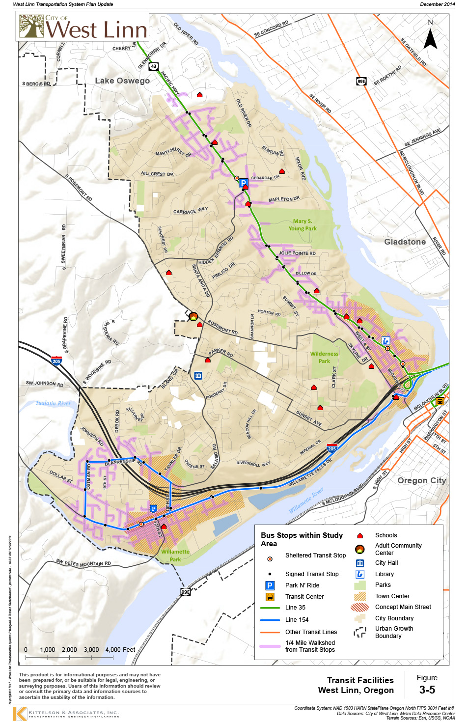
Transit Facilities

Thank you for participating! We will be using your feedback to develop and prioritize solutions to the transportation needs you’ve just reviewed and provided feedback on. Come learn about the proposed solutions at Community Workshop #2 on April 8th, 2015.
To stay involved
- Participate in Community Workshops – April 8th and again in July (these will also be available online)
- Attend Citizen Advisory Committee, Planning Commission, and City Council meetings (posted on the City’s website)
- Visit the project website to review project memos and see upcoming meeting updates: www.westlinnoregon.gov/planning/transportation-system-plan-update
- Call or e-mail Zach Pelz at (503) 723-2542 or zpelz@westlinnoregon.gov
Final questions
Before you leave, be sure to submit any comments you've provided.
