Project Information
- Project Summary(pdf | 185KB)
- Frequently Asked Questions(pdf | 159KB)
Stations
Information and survey questions about the Comprehensive Plan are organized around the following topic areas:


The Comprehensive Plan provides future direction for:
- how best to use the land,
- where transportation improvements should occur, and
- how to protect and enhance valuable natural and other resources.
This process will update three documents:
- the Comprehensive Plan document, which acts as the County’s land use mission statement. It sets policies for activities relating to the use of land, including sewer, water, and transportation systems, recreational facilities, natural resources, and air and water quality management programs.
- the Transportation System Plan, which is the element of the Comprehensive Plan that addresses our transportation needs, and
- the County Development Code, which implements the Comprehensive Plan through zoning and land use regulations.
How is the Comprehensive Plan Related to Other County Plans and Policies?
The County’s Comprehensive Plan is a guide for future growth and development in rural parts of the County. It sets goals and policies for how these rural areas should grow or change over the next 20 years. It focuses on how to best use our land, how to connect people to the places they need to go, and how to protect and enhance valuable natural and other resources. The Comprehensive Plan provides broad policy guidance to support implementation of County goals through a variety of other County plans and processes, including the following:
- Rural area plans which will be updated and integrated into the Comprehensive Plan as part of this process
- County Land Division (Zoning) Ordinance, including Land Use Permitting procedures and processes, building permitting and natural resource protection requirements
- Transportation System Plan and associated capital facilities plans for roads and other transportation facilities
- Coordination with other counties and cities in the region, as well as Metro regarding connections to neighboring areas
- Coordination and consultation with state and federal agencies regarding natural resource management and protection issues, policies and plans (e.g., the Columbia River Gorge National Scenic Area Plan)
Multnomah County also provides a variety of other services which are not directly related to the Comprehensive Plan, including health and social service programs, tax assessment, marriage licenses, animal control, elections, land records and other similar programs and services. Those activities will not be addressed during the Comprehensive Plan process.
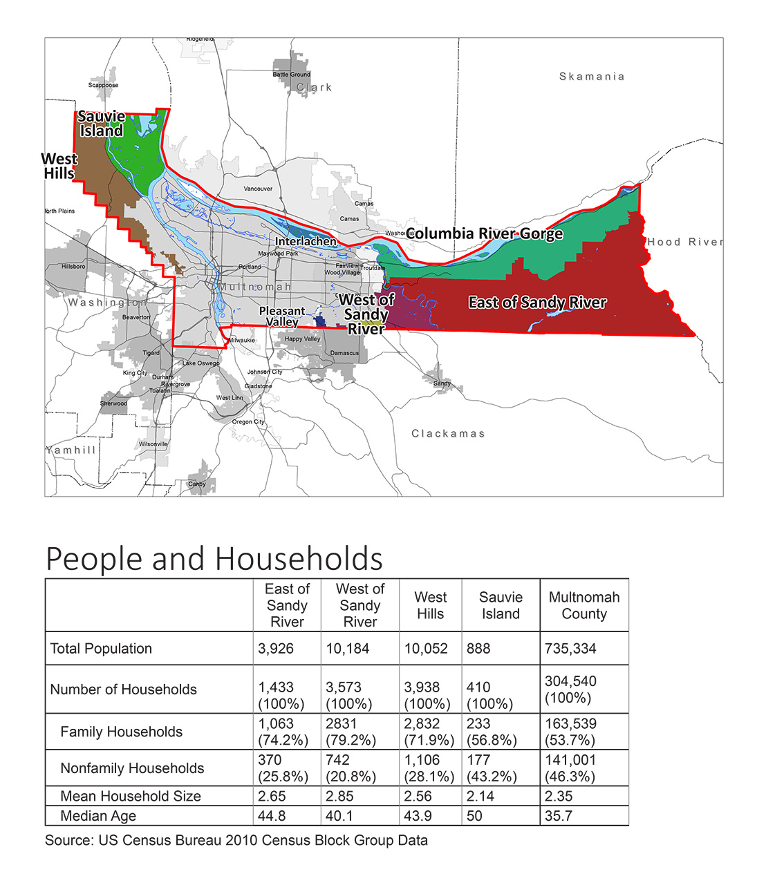
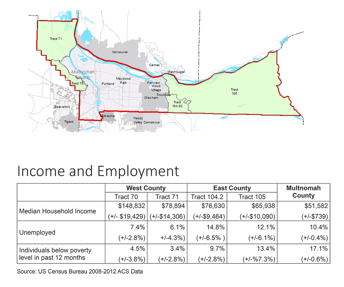
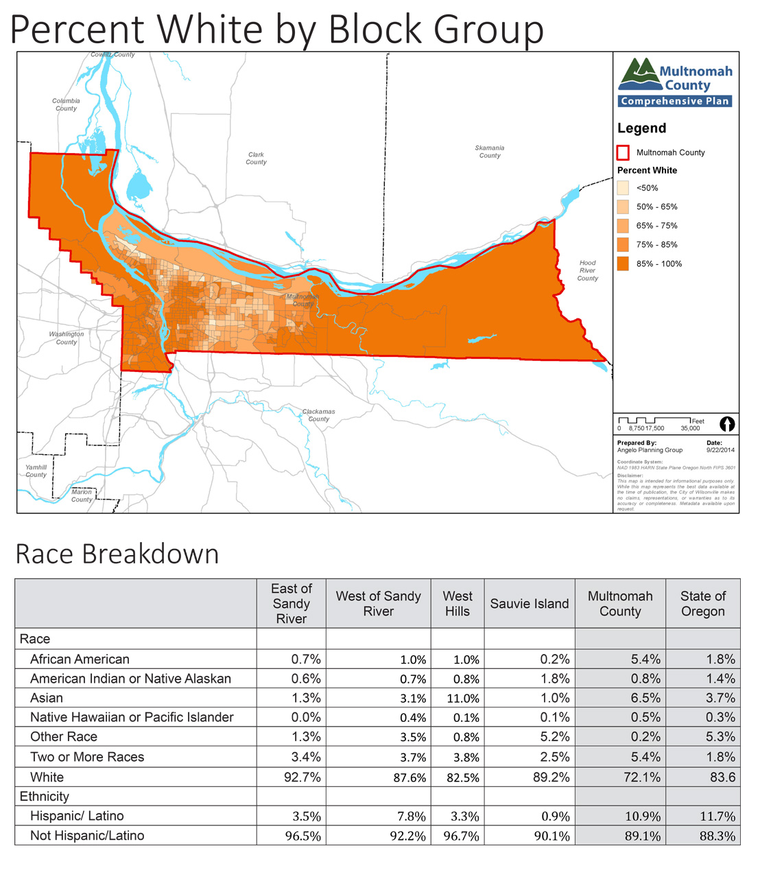
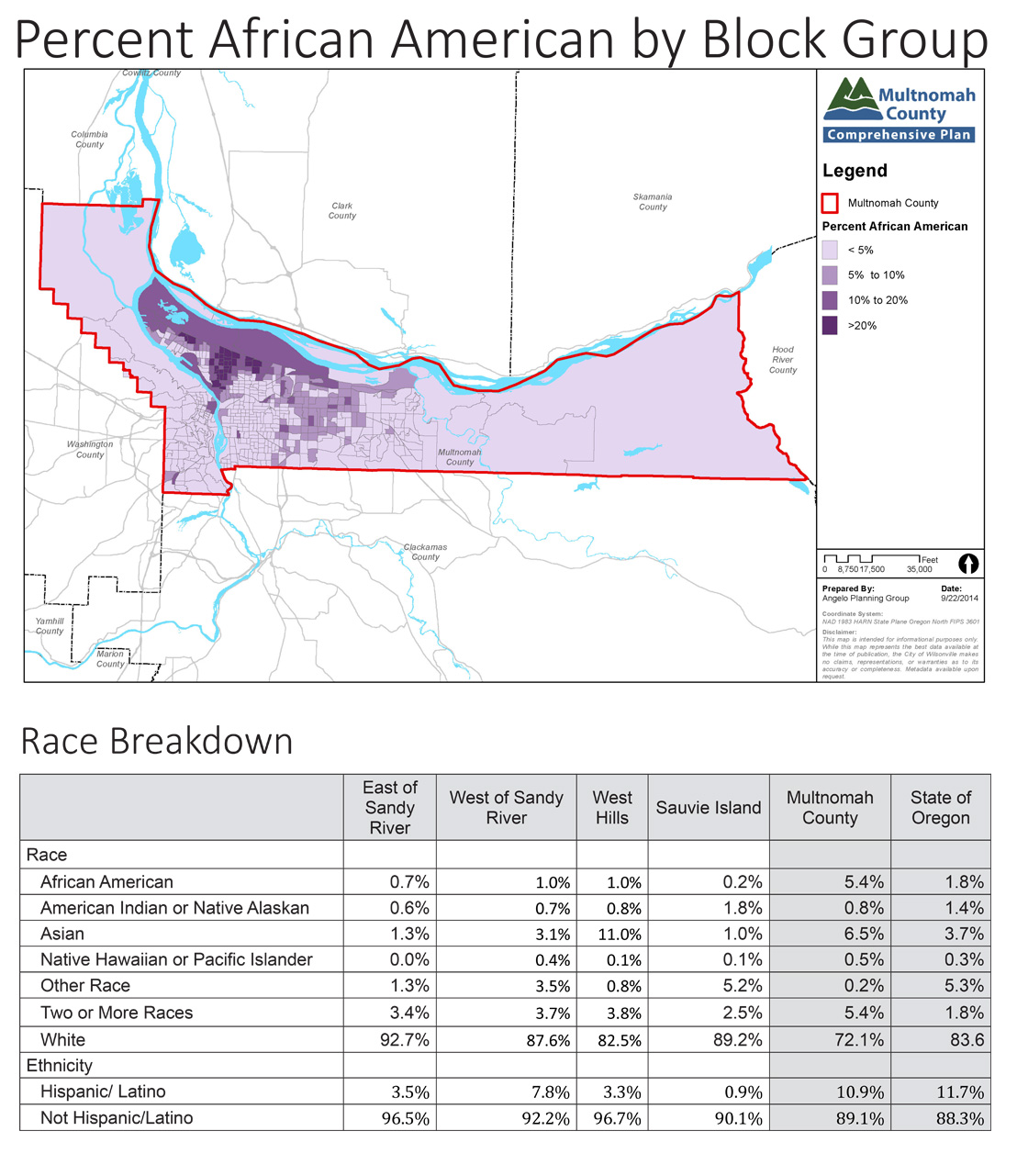
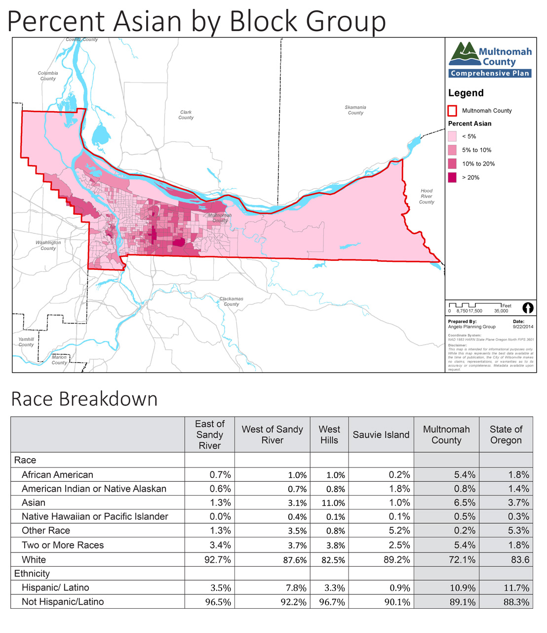
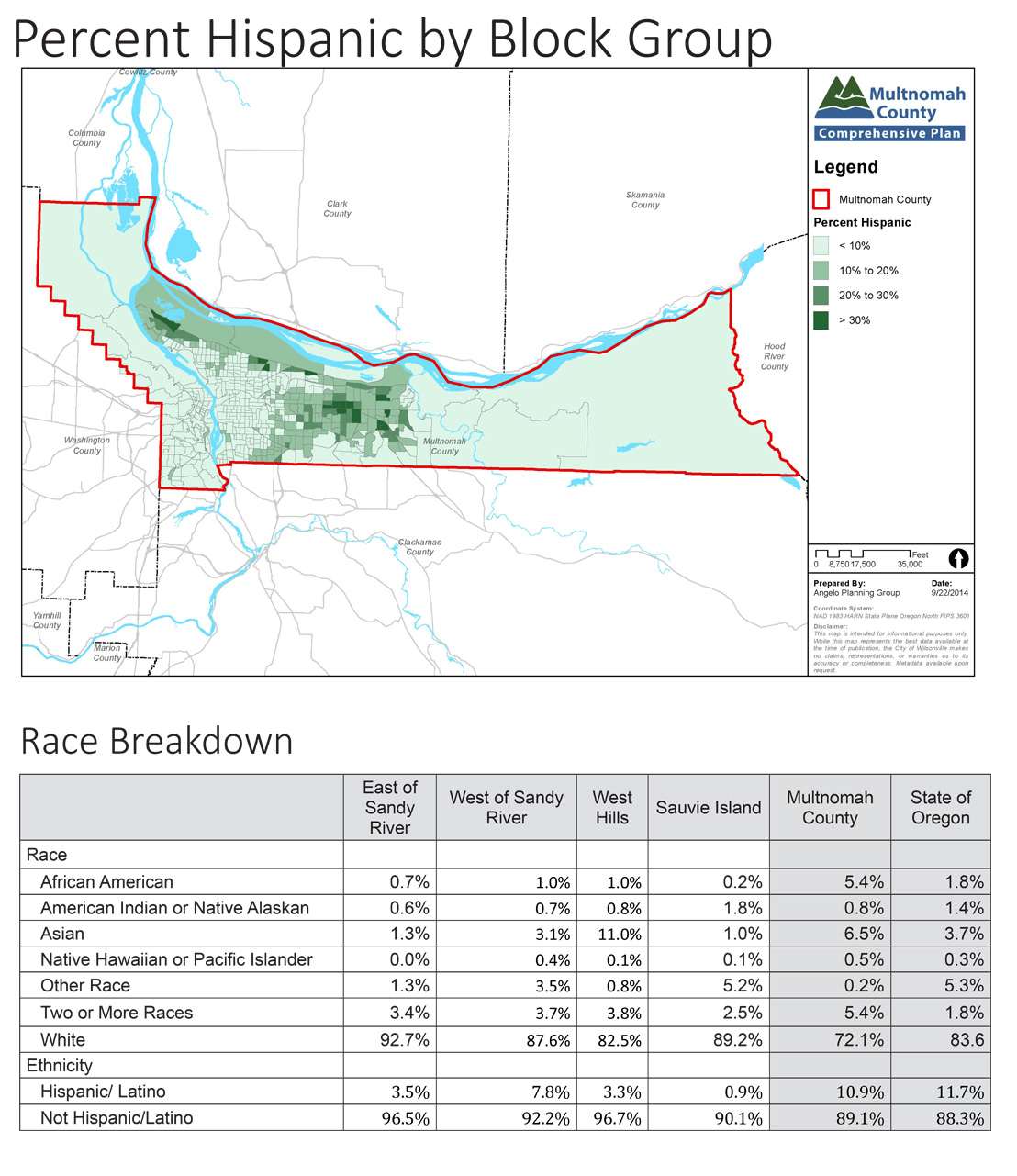
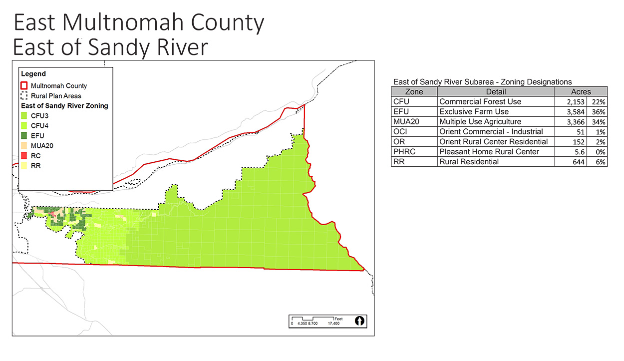
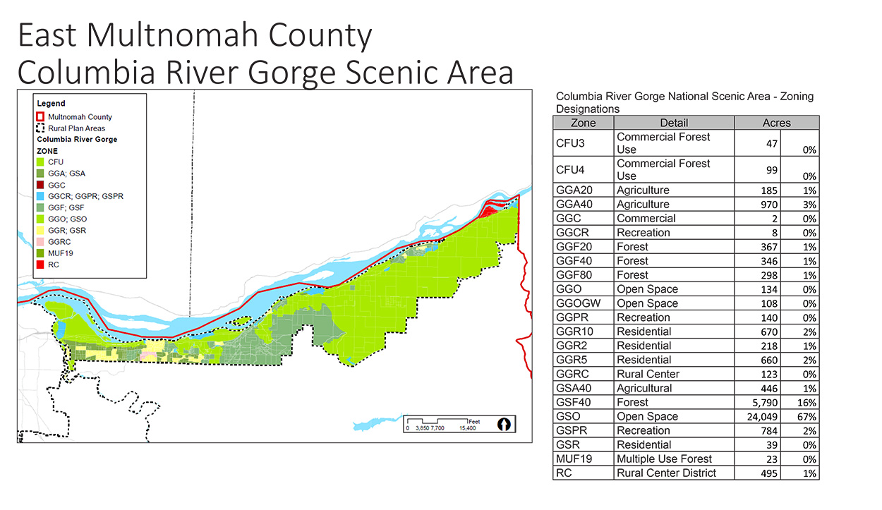
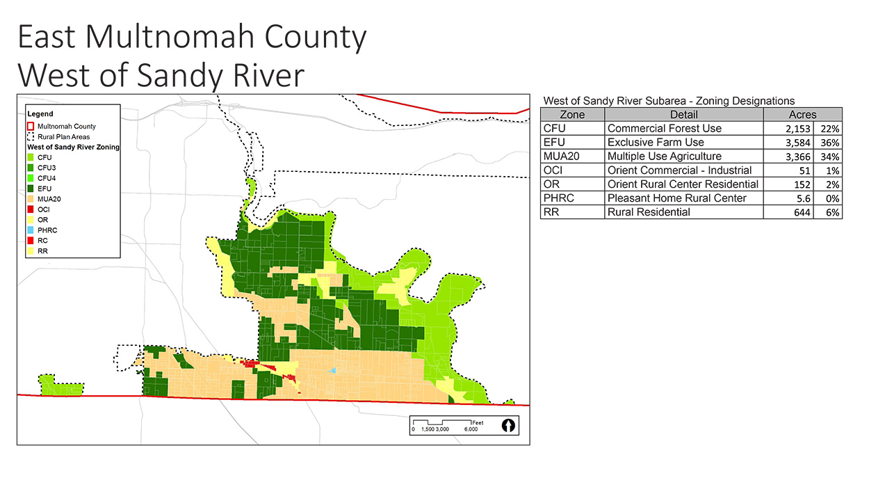
What we know
The project team has done some preliminary research on County demographics and how land is currently used and zoned. Click on the display boards on this page to learn more.
Statewide Planning Goals related to Land Use:
- Goal 1: Citizen Involvement
- Goal 2: Land Use Planning
- Goal 10: Housing
- Goal 14: Urbanization
Public Comments
Statewide Planning Goals related to Transportation:
- Goal 12: Transportation
- Goal 13: Energy Conservation
Public Comments
High Speed limits encourage drivers to drive faster than safe for wildlife, farm vehicles, and walkers and bikers who don't have shoulders/lanes.
Bicycle lanes are welcome. Regular road maintenance is necessary/doesn't occur on my road (Clara Smith). Are there plans to bring public transit to Corbett?
Add bike lanes to Skyline! It is heavily used by cyclists and is dangerous for bikes and cars. Also pedestrians could use the bike lane.
Bike lanes on Skyline and walking paths are dangerous for all.
Noisy motorcycles and trucks ruin the tranquility of the beautiful farms and forest. Restrict them except for 1 route.
Get the bikes off the road. They are dangerous. Create off-road bike and walking trails like Washington County has. At least bike and walking lanes!
Use traffic calming measures to try and reduce speeds on Skyline, Kaiser/Brooks, Newberry, and Germantown. Use signage, chicanes, pedestrian crossing points, and rumble strips.
Need speed enforcement on Cornelius Pass Road! And prohibit truck jake brakes.
Bicyclists are large users of East County roads. They need to help pay for the roads.
Would like some Trimet service in East rural area.
Angels Rest Parking is unacceptable! Cars parking all over the road is dangerous for bikers, hikers, kids, and motorists. There is a perfect spot down hill from the trail head to cut in a large parking area to get the cars off the road.
I agree, bicyclists are hard to see and difficult to pass. They have no personal accountability (i.e. license plate). We used to be able to ride our horse on the gravel side of the road, now all of the shoulders are paved for bicyclists.
Bicyclists from the city seem to have no regard that rural people work on weekends. Cyclists do not follow the rules of the road and have NO courtesy.
Parking at Angel's Rest needs to be expanded. Too many hikers on the highway, reducing traffic down to one lane. This is dangerous.
In Denmark I was told cyclists are cited for anything. Violations go against their drivers license. Good idea! Rules of the Road are followed there!
Multnomah Falls is a traffic nightmare on a sunny day. Pedestrians walk in the lanes of vehicle traffic. There are too many people.
Bike riders should have a license. They should pay for improvements for their pleasure.
Look at making the scenic highway one way in the summer. It is too narrow for the traffic it gets. We have a lot of bikers on specific roads near Corbett that have no shoulders or bike paths. Very dangerous.
Statewide Planning Goals related to Public Facilities:
- Goal 8: Recreational Needs
- Goal 11: Public Facilities and Services
Public Comments
Allow public service providers the courtesy to get permits to enable the protection of their service district (i.e. fire department)
Make decontamination of adequate water supply a condition of development.
Do no fix what is not broken.
It would be nice to have public restrooms for bikers. Could we have a public park for Corbett?
Statewide Planning Goals related to Farms, Forests, and Mineral Resources:
- Goal 3: Agricultural Lands
- Goal 4: Forest Lands
Public Comments
Land use law and tax systems should support small independent businesses which are consistent with agricultural goals but protect the environment.
I believe in restrictions for more of the area, but some are too rigid.
Statewide Planning Goals related to Environmental Quality (Air, Land, and Water):
- Goal 5: Natural Resources, Scenic and Historic Areas, and Open Spaces
- Goal 6: Air, Water and Land Resources Quality
- Goal 15: Willamette River Greenway
Public Comments
Development puts too much pressure on wildlife and resources. We need boundaries and safe zones across the west hills.
Air traffic should be much higher during foggy conditions.
The weed control is an issue, along streams, wetlands and forests. Regulations in place now are not enforced! Where is the soil and water department?
The County should preserve historic buildings and encourage remodel and purchase of them. Why was Bridal Veil church torn down? A huge loss.
How about weed control of noxious weeds along county right-of-ways? I am not happy about private lands also spreading tanzy seeds, etc.
Is it any wonder National Grassland enforce and require certified weed free hay if camping, etc.? East does not want what we already have. Smart!
"Historic" should mean something, not just old. When will the County answer to submitted plans for the future Crown Point historical building in Corbett?
Rural residents should be allowed to do the Wildlife Habitat Plan.
Statewide Planning Goals related to Natural Hazards:
- Goal 7: Areas Subject to Natural Hazards
Public Comments
It would be great to get resources in place to support rural homeowners in case of a disaster (workshops on generators, etc.).
Landslide and earthquake hazard is real and needs to limit building on street areas.
Regulate and restrict building on steep slopes. Earthquake and slide failure is a great hazard.
Concerned that DOGAMI Lidar surveys will be used to restrict buildable areas due to landslide hazard. People should have information and make their own decisions on the risk of The Big One.
People with existing land with a replaceable dwelling and well and septic in potentially hazardous areas should be grandfathered in for development.
Appreciate the snow removal. Buses during snow would be appreciated.
In the winter of 2008, the county would not come across the Sandy River with a snow plow. Locals cleared the road. The same thing happened in 1996. Organize locally.
Statewide Planning Goals related to Rural Economy:
- Goal 9: Economic Development
Public Comments
Tax plans currently encourage development rather than conservation. Consider tax credits for preserving trees, wildlife, and watershed.
Encourage home occupation uses in rural areas.
Tourism and low environmental impact business should be encouraged.
Having land use planners working with businesses to allow economic development.
Cottage industries should be encouraged.
If the smart growth goal is to reduce how far people drive to work, then people should be able to live and work here in the community. There used to be several mechanic shops, stores, hotels and restaurants in Springdale, Corbett and Chanticleer Point.
I hope that the County can figure out how to allow people to work out of their homes, especially when it constitutes an email, phone number and mailing address and UPS deliveries, etc.
We should be able to make money off the tourists by small scale development in Springdale and Corbett.
Decision Making Structure

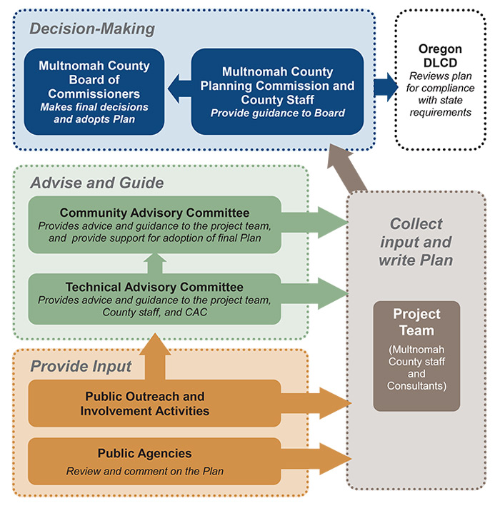
How Decisions will be Made
Final decisions regarding potential changes to the Comprehensive Plan will be made by the Multnomah County Board of Commissioners, based on guidance from County staff and the Multnomah County Planning Commission. Community and Technical Advisory Committees will provide advice and guidance to the project team. Members of the public will have the opportunity to provide input and stay involved throughout the process.
Get Involved / Stay Informed
- Sign up for our mailing list at multco/compplan.
- Attend future public outreach events.
- Fill out the comment form on this site by November 19 or visit multco.us/compplan to provide comments anytime.
- Contact Multnomah County:
Rich Faith
Multnomah County Senior Planner
503-988-3931

I am concerned about the pressure from urban development in adjacent areas, particularly North Bethany. We need Boundary Zones!
Columbia Gorge Scenic area: Property that is 100% screened by trees should not be subjected to to the same max sq ft limitation on outbuildings.
I live in Corbett. My main interest is to keep Corbett rural, but to also allow residents more housing options such as ADU's or granny flats.
Soil erosion and water quality impacts from farms. Shadow conversion and loss of farm land. Habitat connectivity and protection.
Local property rights should be considered with more weight.
Allow leeway if a land has multiple restrictions (such as wildlife, streams, "clusterings," and driveway location).
Zoning: no urban housing. Forest: divide land in 3-4 acre parcels. School Zone: keep Skyline with Lincoln. Keep in mind Mult Co, West Hills and other dense parts of the county have very different needs.
Preserve rural Portland. No massive housing developments.
This is the last close-in rural land in metropolitan area. Preserve it as rural.
Preserve farm and forest use, and maintain rural character.
Speed up the permit process. It takes years in some instances.
Provide better instructions (on web) on how to proceed with land use planning. Clarify what county and cities and responsible for (with public and within your staffs).
Simplify land usage policy. I should not pay $1,200 to place a $300 shed on 18 acres of property and wait for 60 days for a county decision.
Clearly state what your goals are of this Comp Plan. What is the reason for doing it? What will guide the decision making process (other than public input)?
As a property/forest owner I am very concerned about relaxation of the urban growth boundary. We cannot lose the natural beauty that is Oregon.
Greater consideration must be given to the recent survey results showing 80%+ of the population wants a single family detached home.
I do not want Corbett to become a suburb. I agree with land use policies but streamline the process to account for all the costs and steps!
It would be interesting to know the average property size in east county. I suspect that most are small. Maybe there should be looser rules.
Develop a rural center at Skyline/Cornelius Pass to better serve the most basic needs of local residents to reduce the need for longer trips.
Maintain and protect forest and farm owners' rights. Please do not take more away or make it more complicated.
The National Scenic Area plan is currently separate and discrete from the plan for rural Multnomah County. It should updated and integrated.