Stations
Go directly to a station using the buttons below, or at the top of the screen to move through the stations in order.
= Page includes questions or opportunities for comment.
Why are we doing this project?
Northwest in Motion aims to give people more choices for daily travel. Giving people more transportation options like walking, bicycling, and public transit means they have the choice to bypass traffic congestion, use limited roadway space more efficiently, and avoid having to look for scarce on-street parking. Providing people these choices will be especially important as the neighborhood continues to grow as a residential, commercial, and employment destination.
What we've heard
In Summer 2018, PBOT hosted a series our engagement activities to gather feedback on what areas of the neighborhood need improvement.
- Online Open House. Using an interactive, online map community members were able to identify specific locations throughout the neighborhood that they felt needed improvements. A total of 96 people participated in the online open house. 150 comments were added to the map.
- Walks and Rides. The project team led 2 public walks and 2 public bike rides around the neighborhood. Community members were able to voice concerns and possible solutions about specific locations along the routes.
- Presentations and Focus Group Meetings. We have engaged NW businesses and residents living in affordable housing, which included seniors and people with disabilities.
The feedback from these activities uncovered a number of key themes:
Vehicle speed is a major concern.
High driving speeds was the most frequent comment theme, noted in over 30 of the comments. “Speed or volume of traffic” was also the top issue category marked for comments related to biking. While some commenters suggested reducing speed limits to 20mph or less, a larger number of comments noted that drivers often didn’t adhere to existing limits. At least nine comments encouraged the use of more 4-way stops as a deterrent to speed.
Vehicle speeds and volume of traffic is an issue on existing bikeways.
Most comments about biking related to the existing main bike corridors, with “speed or volume of traffic” as the most common issue category marked for these comments. Seven people explicitly mentioned that the volume of traffic on existing greenways made it hard to feel comfortable or safe while riding. Five people requested the use of more diverters in these areas.
People who bike and/or walk want improved visibility at crossings.
A full 65% of comments about walking and over 22% comments about biking were related to difficult or unsafe crossings. The most frequently mentioned issue was visibility: Parked cars or other obstructions block the sightline, making it unsafe to cross, even at existing crosswalks. Four people mentioned curb bulbs could be a good solution to this issue; while others mentioned 4-way stops as a solution.
Sidewalk improvements are desired.
Nearly 20% of comments related to walking related to “missing or deficient sidewalks.” Among these comments, cracks and uneven walking surfaces were frequently mentioned as problems for walkers.
Traffic circles are not well-loved.
At least 10 comments – from drivers, bikers, and walkers – noted that the small neighborhood traffic circles caused more problems than they solved with cars forced to move into the pedestrian crosswalks to get around them. The majority of these comments related to the traffic circles along 25th Avenue.
Everett is challenging for all users.
As the second most frequently mentioned street (after NW 23rd Avenue), users of all types felt that the current configuration along Everett is an issue. Drivers were not happy with the bike lane and bikers did not feel drivers respected the bike lane, particularly with left turns. The area around the freeway entranc e was cited as a particularly dangerous and uncomfortable area.
Poor connections to neighborhood from the east and north.
All of the most frequently mentioned intersections were crossing I-405 or Burnside. Many comments mentioned feeling unsafe connecting to the neighborhood from these areas even with existing bike and walk infrastructure. Several people mentioned that the noise, pollution, or general street conditions around I-405 make it uncomfortable to bike and walk in this area regardless.
More space wanted for biking and walking along NW 23rd Avenue.
23rd Avenue was the most commonly mentioned street. Several people mentioned that they would prefer to be able to bike or skateboard along 23rd since it has so many commercial destinations, but that there was no space to do so. Several people also mentioned that walking along NW 23rd Ave. was too crowded with people and street amenities from businesses.
You can view and download the full outreach summary report on the Northwest in Motion website.
Project Area


What are street classifications?
Street classifications are PBOT’s policy guide for which modes should be emphasized on which streets, and what kinds of trips should be served. For example:
- Local Service Traffic Streets are meant to primarily serve local automobile access to households or businesses
- Neighborhood Collectors should serve as a primary route for people traveling in or out of the neighborhood by car
- City Bikeways are meant to be a bike route serving shorter trips
- Major City Bikeways are meant for longer bike trips
Street classifications give us a sense of how many people are expected to use these streets for which modes, and they help to balance which modes are prioritized on each of our streets.
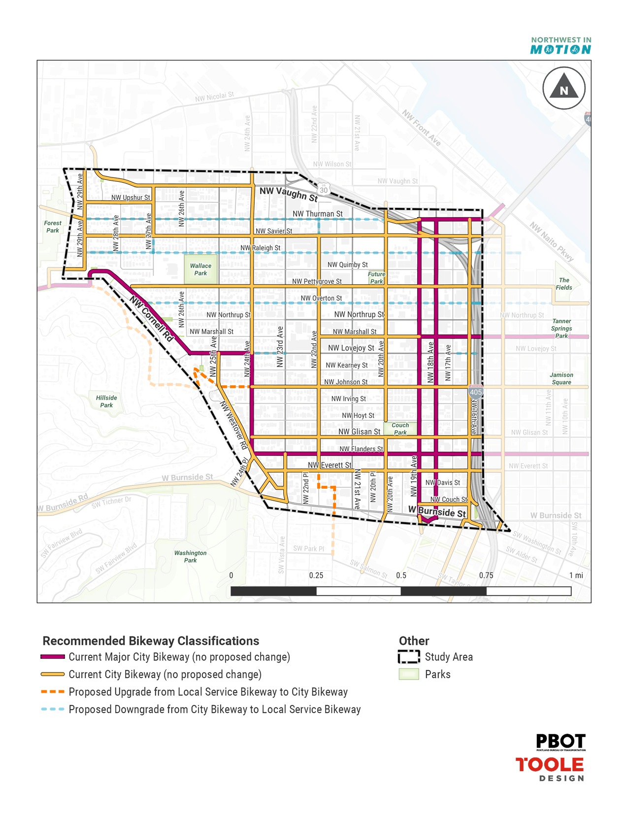
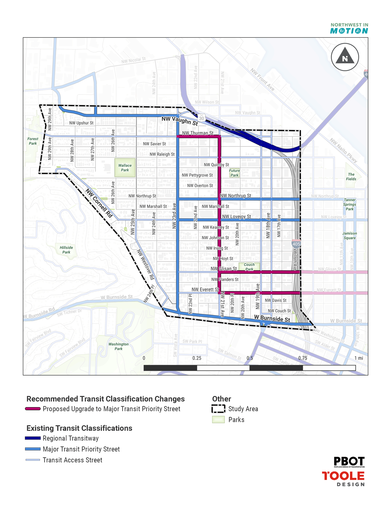
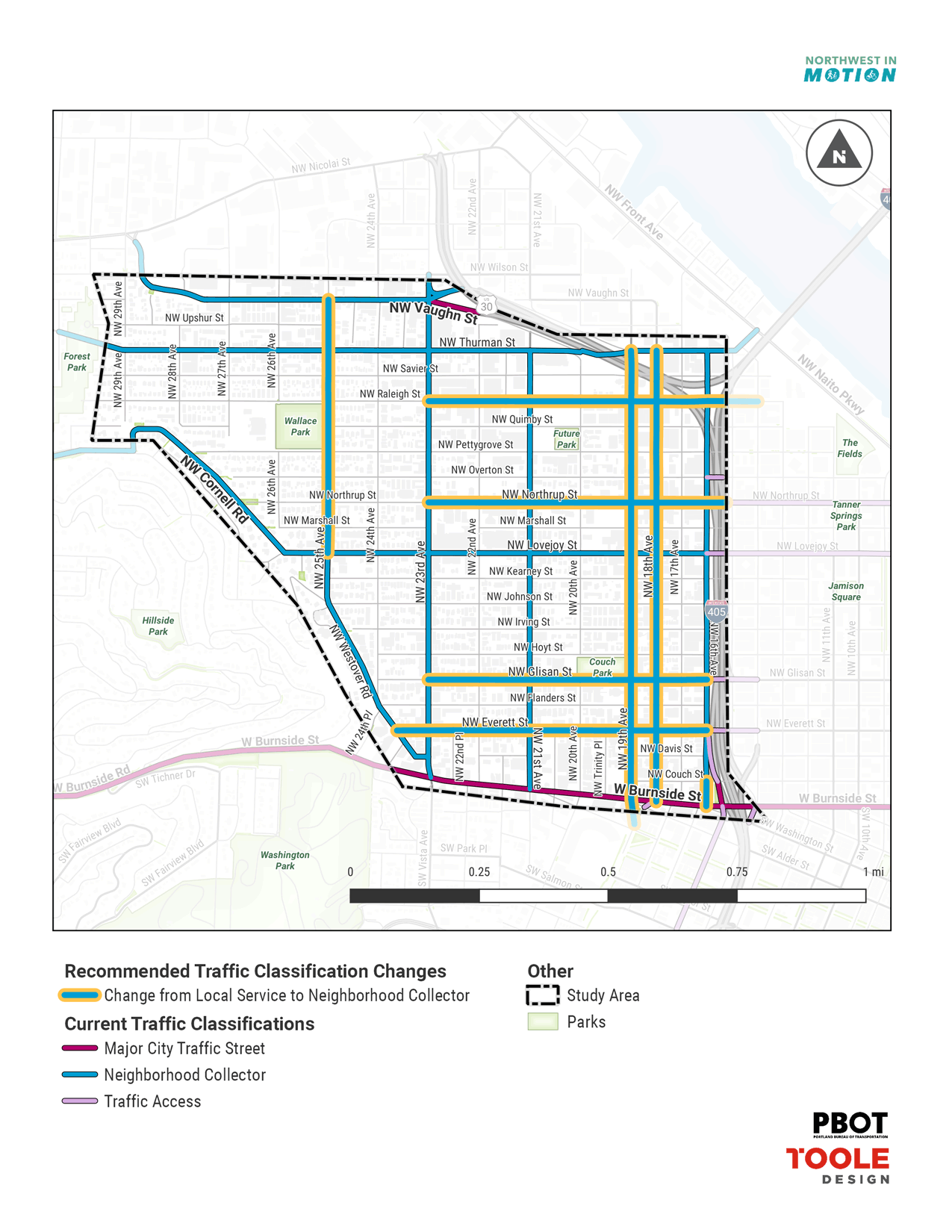
Street Classifications in NW
Early on, we recognized that the Bicycle and Traffic street classifications in the NW District were out of date and did not adequately organize the transportation network.
- NW has an extremely close spacing of City Bikeways, making it hard to know where to focus investment in bicycle facilities.
- NW has very few Neighborhood Collectors despite the high density and narrow streets in the neighborhood.
Knowing this, we have developed a proposal that provides a better balance of traffic and bike streets and provides clarity about where traffic is expected to go when some streets are prioritized for bikes. We have also recently added an update to the Transit classifications, based on feedback from TriMet about their plans for frequent bus service expansion in the future.
The other four street classifications (Pedestrian, Freight, Emergency Response, and Street Design) are either being updated through other processes or are considered adequate at this time. For more information about the Street Classifications, including policy descriptions and maps of current classifications, consult the Transportation System Plan, Chapter 3.

Bicycle
The proposed updates result in more consistent spacing of bikeways (roughly three blocks apart), with closer spacing in the eastern and southern areas closer to the Central City. Existing bikeways on Overton and Raleigh are proposed to be replaced with Pettygrove and Savier, respectively, shifting bikeways to lower-traffic streets that will be more comfortable for riders of all ages and abilities. The main street portion of Thurman is proposed for removal as a City Bikeway due to conflicts with needed curb zone space, and the availability of Savier as a parallel route. Finally, a new bikeway is added on Westover Rd (providing a parallel route to Cornell Rd) and a new bikeway is added on 22nd, Davis, and King connecting NW District to the Kings Hill area.

Transit
The proposed change upgrades the route of the Line 77 bus on 21st Ave and Everett/Glisan from Transit Access Street to Major Transit Priority Street, reflecting TriMet’s plans to upgrade the Line 77 to frequent service in the coming years. This change will provide guidance that these streets should be prioritized for transit access and operational efficiency to the extent possible.

Traffic
The proposed updates provide Neighborhood Collector spacing more typical of other inner Portland neighborhoods that developed during the streetcar area, where a combination of high density, narrow streets, and a full grid of streets necessitates closer spacing of collector streets to handle traffic. Spacing is closer in the areas closest to the Central City, and further apart moving west toward Forest Park. All the proposed upgrades are meant to formalize the way these streets are already functioning—in other words, Everett/Glisan, Northrup, Raleigh, 18th/19th, and 25th already all carry higher traffic volumes than typical local streets, and generally carry longer trips in and out of the neighborhood, so Neighborhood Collector is an appropriate designation.
Question


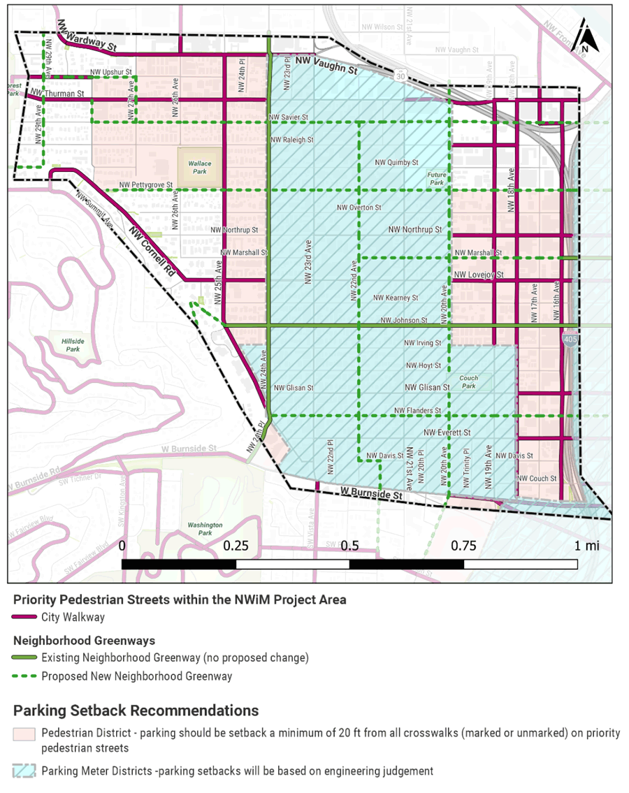
Parking setbacks
Parking setbacks are recommended for various intersections throughout the project area. These setbacks will occur incrementally as intersections are improved and Neighborhood Greenways are constructed/upgraded. (See image for more information.)
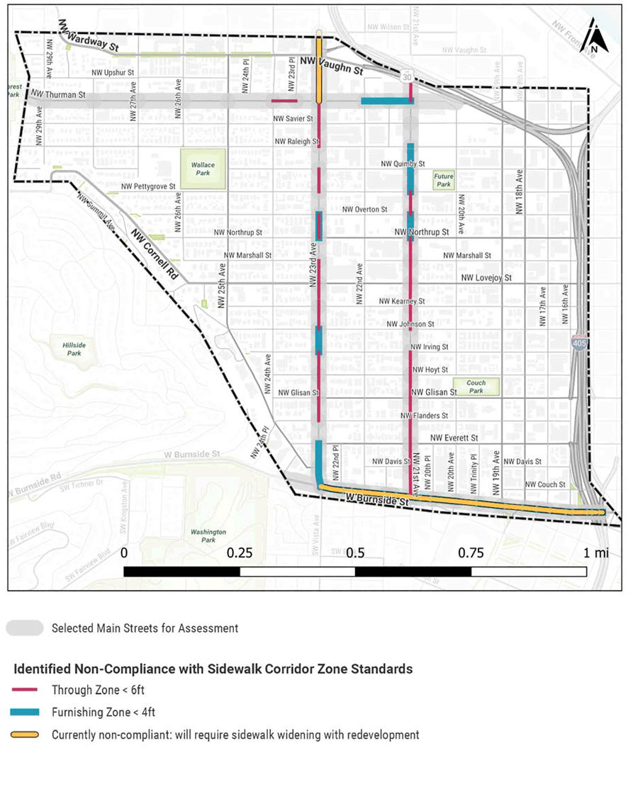
Main Street through and frontage zone improvements
Main Streets in the project area are consistently lacking in pedestrian through zones and frontage zones. As development occurs or as opportunities present themselves, additional ROW for sidewalks should be identified. In addition, many of the areas that lack a clear pedestrian through zone could be improved through physical or visual delineation, or in educating adjacent property owners about where they can (and cannot) place materials (café seating, A-boards, etc.) on the sidewalk. (See image for more information.)
Transit amenities
Through Northwest in Motion, PBOT is offering recommendations on projects that would improve access to transit and make transit more comfortable, but PBOT cannot fund amenities (shelters, trash cans, benches). That said, having appropriate amenities at each transit stop is still an important part of a complete active transportation system. Click to view the list of amenities needed to improve the transit stops to TriMet standards. This list will be given to TriMet for their information and future planning.
ADA improvements
PBOT is currently producing an ADA Transition plan and is under an agreement to build 1,500 curb cuts a year over the next 12 years to make the city’s sidewalks ADA compliant. PBOT will have a broader prioritization strategy for the order that these ramps are built and some of these ramps will be within the NWiM project area. Read more about building curb ramps and improving access.
Restrict turns on red
PBOT has received feedback from the public through multiple planning processes, including the Transportation System Plan (TSP), Vision Zero Action Plan, PedPDX (Pedestrian Master Plan update), and Northwest in Motion, that motor vehicle “turns on red” have become a growing problem for pedestrian comfort and safety throughout the City and especially in high‐volume pedestrian areas. In addition, research has shown that restricting turns on red has a demonstrated crash reduction factor for all modes, but especially for vehicle/bicycle and vehicle/pedestrian crashes. Given these factors, we recommend a “no turn on red” pilot program in the NW Pedestrian District, which encompasses most of the NW in Motion project area, to test out the benefits and impacts of this operational change before making a decision on whether or not to continue the restriction and whether or not to expand to other areas.

Parking Setback Recommendations (click to enlarge)

Identified Non-Compliance with Sidewalk Corridor Zone Standards (click to enlarge)


Evaluating Projects
As we continue to develop the Northwest in Motion plan, we will be using a set of criteria to help us refine and prioritize the list of projects. Review the list of criteria that PBOT uses for many of its transportation projects.
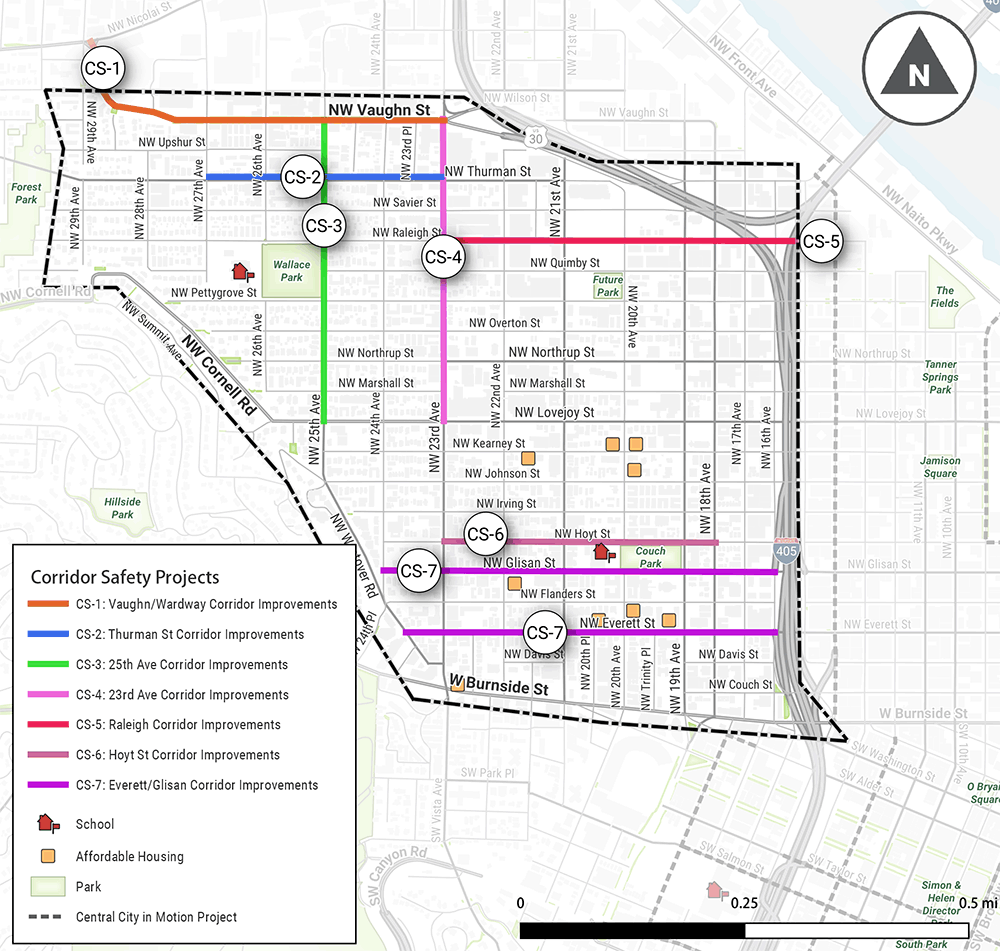
Corridor Safety Projects
Corridor safety projects focus primarily on pedestrian improvements along and across busy streets. These may include sidewalk improvements, traffic calming, or enhanced crossings to help people safely walk to community destinations such as parks or schools. We have also incorporated additional multimodal improvements where needed to address other concerns, such as pavement quality, signal timing, bike lane safety, and transit access.

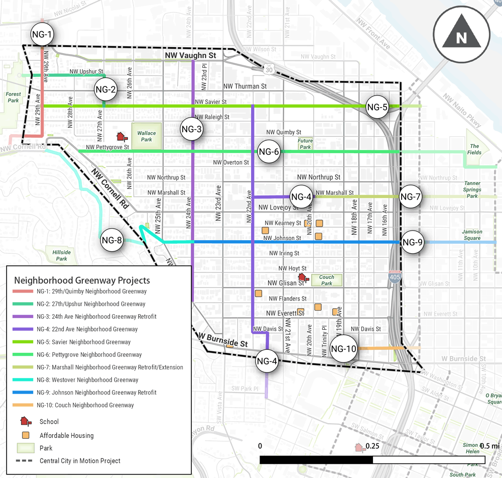
Neighborhood Greenway Projects
Neighborhood greenways are low-stress bike routes using local streets with low traffic speeds and volumes. They typically feature speed bumps, diverters, and other traffic calming tools, and parking is usually retained on both sides of the street. They also include enhanced crossings of busy streets, providing a benefit to pedestrians as well. Some of the proposed projects involve retrofits of existing neighborhood greenways, improving them to meet our current volume and speed guidelines, while others would be brand new neighborhood greenways.
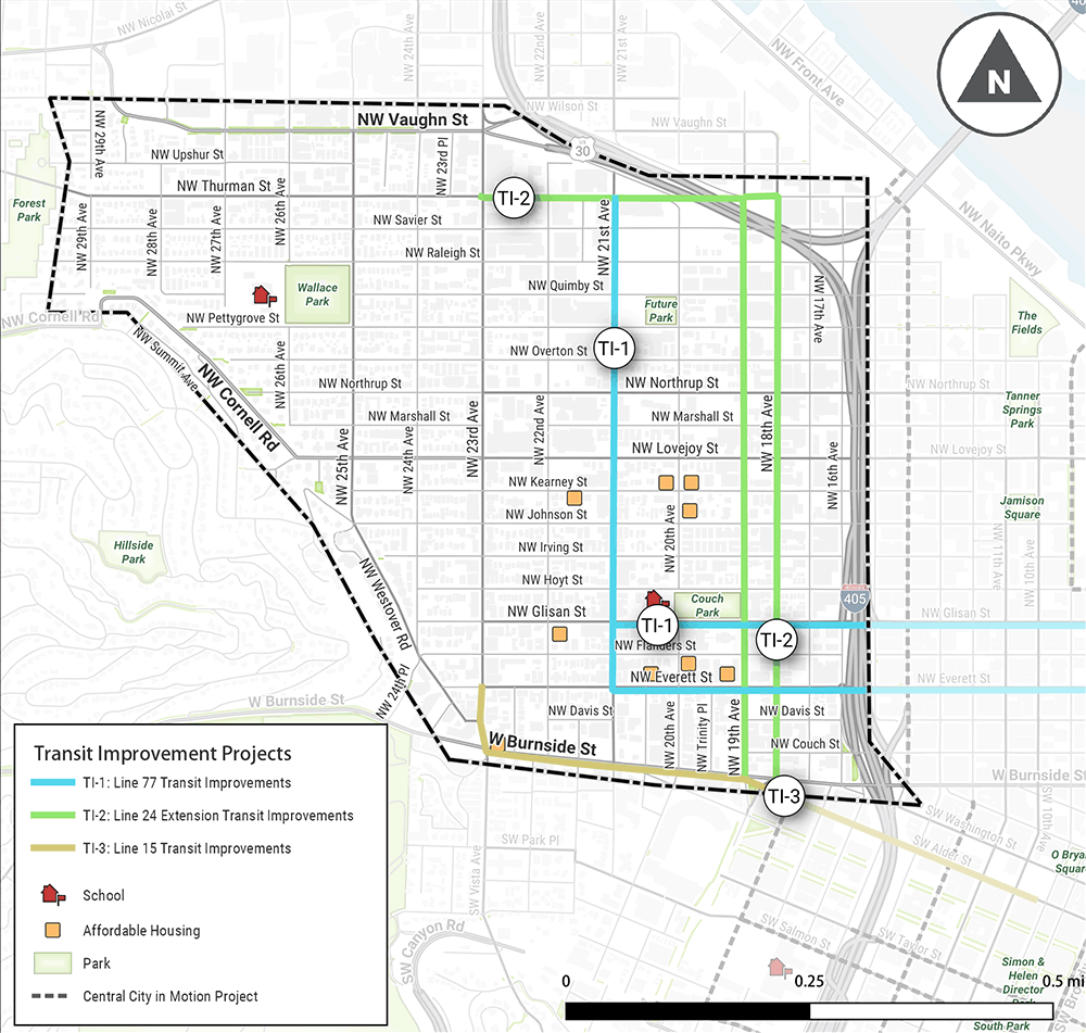
Transit Improvement Projects
Transit improvements are focused on making public transit service more attractive to use by improving access to transit stops, enhancing bus stop quality, and helping transit move more quickly and reliably on our streets. Examples include adding marked crosswalks at bus stops, providing curb extensions or transit islands for bus stops, adding a protected left signal to ease a bus turn, or shifting a bus line to a more direct route. Two of the proposed projects would improve existing bus lines in NW Portland, while another would improve a new bus line that will launch in 2019.
Other Projects
The interactive map shows several funded biking and walking projects (shown in gray) that are already planned for construction in the neighborhood.
Potential Projects Map
Click and drag to explore the map, click lines, shapes, and icons to read about individual projects. Turn layers on and off and browse the list of projects by clicking the  button in the upper left of the map window. You may need to turn off layers with large map objects to select other objects beneath.
Questions
(Consider the four Evaluation Criteria as you answer the questions below.)
- Equity - How much does this project benefit traditionally underserved communities?
- Safety - How much will this project reduce the risk of fatal and serious injury crashes?
- Demand - How many people are expected to benefit from this project?
- Connectivity - How much does this project improve or expand the priority networks for each mode?
Which five projects best address the project criteria? Why?
Project 1 of 5
(Select one.)Why did you choose this project? (1 of 5)
(Check all that apply.)Project 2 of 5
(Select one.)Why did you choose this project? (2 of 5)
(Check all that apply.)Project 3 of 5
(Select one.)Why did you choose this project? (3 of 5)
(Check all that apply.)Project 4 of 5
(Select one.)Why did you choose this project? (4 of 5)
(Check all that apply.)Project 5 of 5
(Select one.)Why did you choose this project? (5 of 5)
(Check all that apply.)What happens next?
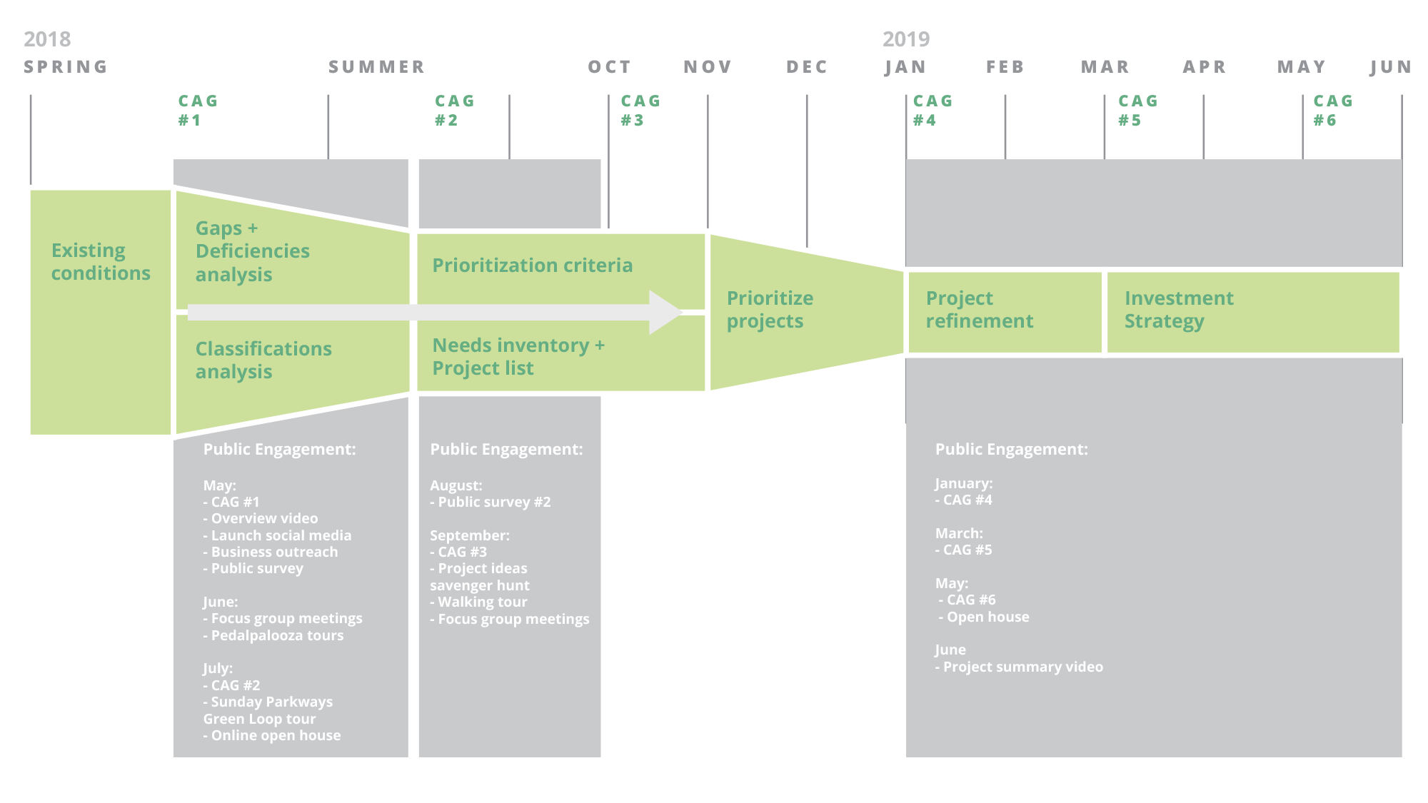
Using the feedback and information gathered from this open house and other outreach activities, the Community Advisory Group will continue to refine the list of priority projects for the Northwest in Motion plan and start to develop an investment strategy for funding and building the projects. Throughout this process there will be additional opportunities for the public to weigh in. For more information about the project timeline or to see the schedule of Community Advisory Group meetings, visit the project website: www.portlandoregon.gov/transportation/nwinmotion
Stay Involved
- Sign up for email updates below.
- Contact us directly: NWinMotion@portlandoregon.gov
- Follow “Portland Bureau of Transportation (PBOT)” on Facebook
- Follow @PBOTinfo on Twitter
Timeline
Final Questions
Tell us about yourself
Participation Demographics (Optional)
The City of Portland complies with all non‐discrimination, Civil Rights laws including Civil Rights Title VI and ADA Title II. To help ensure equal access to City programs, services and activities, the City of Portland will reasonably modify policies/procedures and provide auxiliary aids/services to persons with disabilities. Call 503-823-5185, TTY 503-823-6868 or Oregon Relay Service: 711 with such requests, or visit http://bit.ly/13EWaCg.
