
Stations
Go directly to a station using the buttons below, or at the top of the screen to move through the stations in order.
= Page includes questions or opportunities for comment.
What is the Roads Capital Improvement Plan (RCIP)?
Every few years, Multnomah County updates a plan of roads to improve over the next 20 years. This plan:
Helps the County know how much money (capital) is needed for roads and how to get the most from it.
Lays out which road improvements to make, and in what order.
Why update it now?
For the first time in more than a decade, the County is digging in deep to understand its roads. That’s crucial because:
Many more people live here now than 10 or 20 years ago, and more get around without a car.
Landslides and floods from extreme weather affect County roads more often, especially in rural areas.
With better tools than ever for collecting data, we can make a truly in-depth plan.
What information goes into the plan?
Along with your input last year, the County is gathering two types of information to help shape the plan:
What's on or near a road
- Lanes (how many and how wide)
- Shoulder type and width
- Pavement condition
- Posted speed limits
- Inventory (traffic signals and signs; crosswalks; sidewalks and ramps; driveways; bus stops; striping; storm pipes and culverts; guardrails; bike facilities; on-street parking)
What happens on or near a road
- Average daily traffic
- Collisions and crashes
- Landslide risk
- Lifeline routes
- Description of who lives and works nearby
- Function (such as arterial, collector or local road)
More Information
- Frequently Asked Questions (pdf, 544 kb)
Problem Spots
Last year we asked, "Do you have any problem spots on County roads?"
In response, you mentioned 56 roads. Seven were mentioned at least 10 times. They are ranked below by number of mentions.
| Segment | Road | Mentions | Issues in a nutshell |
|---|---|---|---|
| West | Skyline Blvd. | 38 | Too narrow for motor and non-motor users to safely mix. Speeds too high. Poor sight lines at intersections. |
| West | Scholls Ferry Road | 30 | Confusing speed limits near county border, actual speeds too high. Lack of facilities for non-motor users. Water runs across road, with ice in winter. |
| West | Germantown Road | 20 | High-volume commute route despite being narrow and winding — a poor fit for both non-motor users and large trucks. |
| West | Cornelius Pass Road | 19 | Intersection with Skyline is confusing and dangerous, with poor sight lines. |
| West | Cornell Road | 18 | Too narrow and potholed for motor and non-motor users to safely mix. |
| Rural East | Historic Columbia River Hwy. | 11 | Dangerous intersection with Hurlburt, pros and cons of converting to one-way to mitigate effects of tourist traffic, including by bike. |
| East | Marine Drive | 11 | Needs sidewalks and bike lanes, as well as better intersection controls at 223rd, 185th, Interlachen due to increased freight movement. |
Priorities
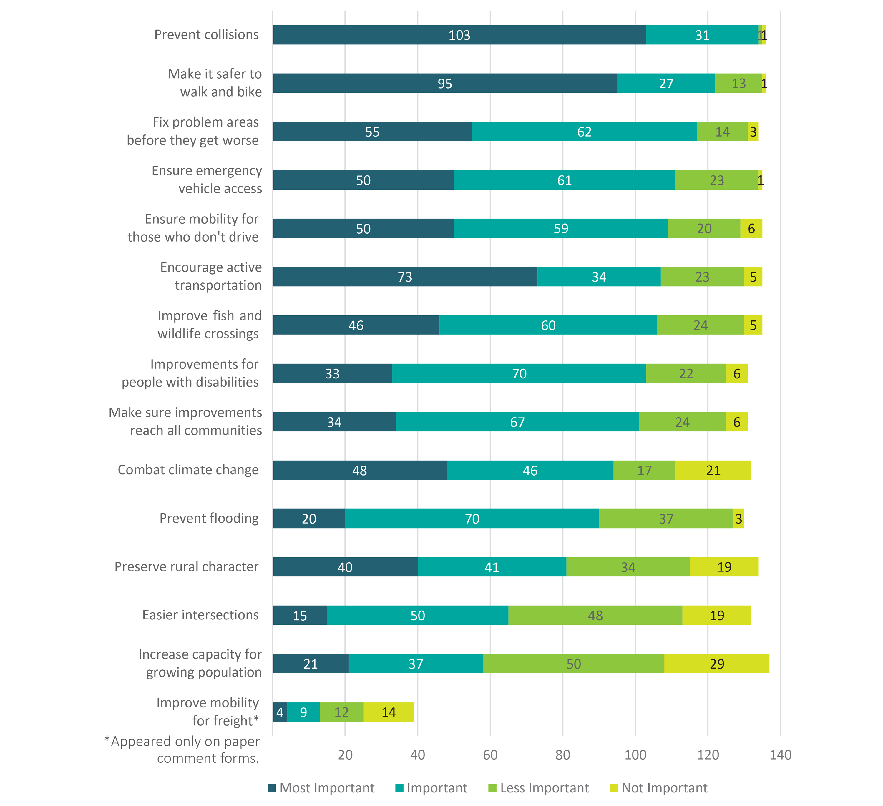
Last year we asked, “What’s most important to consider in planning and building County roads?”
Most priorities received greater than 60 percent support in terms of combined Most Important/Important measures (shaded blue below). “Prevent collisions” received nearly unanimous support, with “Make it safer to walk and bike” a close runner-up.
More Information
For more information about the public feedback we received, please see the Outreach Summary.
Scenarios
Scenario 1
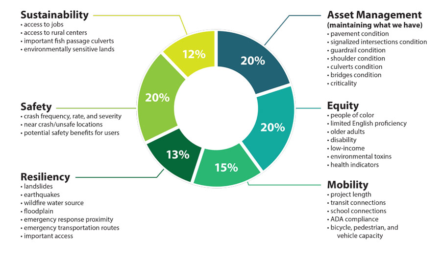
This scenario represents a balanced weighting between the six criteria.
Below is how 10 sample projects would be prioritized if the criteria were weighted by Scenario 1:
- NW Cornelius Pass Rd (Highway 30 to NW Skyline Blvd)
- NE Halsey St (NE 202nd Ave to NE 223rd Ave)
- Larch Mountain Rd (Historic CR Hwy to end of road)
- NE Marine Dr (NW Frontage Rd to NE Sundial Rd)
- Johnson Creek culverts of regional concern
- SW Scholls Ferry Rd (SW Humphrey Blvd to county line)
- Cochran Rd and Troutdale Rd (intersection improvements)
- Stark Street Bridge
- Sauvie Island Loop Roads (shoulder improvements)
- Newberry Rd
Scenario 2
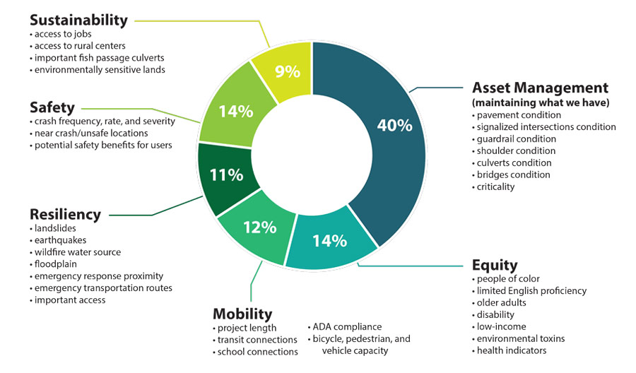
This scenario heavily weights Asset Management: choosing projects based on the condition of what exists there now, including pavement, signals and more.
Below is how 10 sample projects would be prioritized if the criteria were weighted by Scenario 2:
- NW Cornelius Pass Rd (Highway 30 to NW Skyline Blvd)
- Cochran Rd and Troutdale Rd (intersection improvements)
- Larch Mountain Rd (Historic CR Hwy to end of road)
- NE Marine Dr (NW Frontage Rd to NE Sundial Rd)
- Johnson Creek culverts of regional concern
- SW Scholls Ferry Rd (SW Humphrey Blvd to count line)
- NE Halsey St (NE 202nd Ave to NE 223rd Ave)
- Stark Street Bridge
- Sauvie Island Loop Roads (shoulder improvements)
- Newberry Rd
Scenario 3
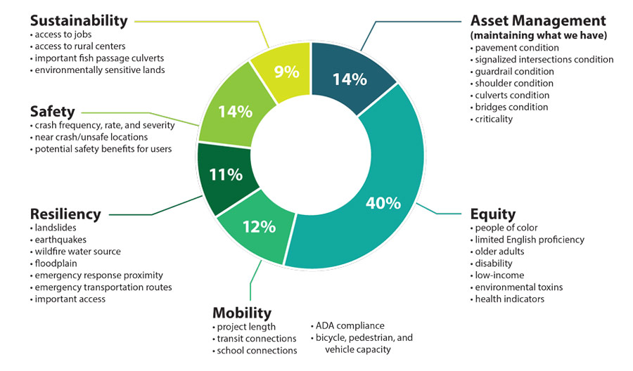
This scenario heavily weights Equity: choosing projects based on serving County residents of all backgrounds and characteristics.
Below is how 10 sample projects would be prioritized if the criteria were weighted by Scenario 3:
- NE Halsey St (NE 202nd Ave to NE 223rd Ave)
- Cochran Rd and Troutdale Rd (intersection improvements)
- Stark Street Bridge
- NW Cornelius Pass Rd (Highway 30 to NW Skyline Blvd)
- Larch Mountain Rd (Historic CR Hwy to end of road)
- NE Marine Dr (NW Frontage Rd to NE Sundial Rd)
- SW Scholls Ferry Rd (SW Humphrey Blvd to county line)
- Johnson Creek culverts of regional concern
- Sauvie Island Loop Roads (shoulder improvements)
- Newberry Rd
Scenario 4
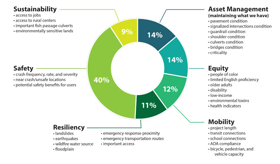
This scenario heavily weights Safety: choosing projects based on data such as crash frequency, and on potential safety benefits.
Below is how 10 sample projects would be prioritized if the criteria were weighted by Scenario 4:
- Larch Mountain Rd (Historic CR Hwy to end of road)
- NE Halsey St (NE 202nd Ave to NE 223rd Ave)
- NW Cornelius Pass Rd (Highway 30 to Skyline Blvd)
- NE Marine Dr (NW Frontage Rd to NE Sundial Rd)
- Johnson Creek culverts of regional concern
- SW Scholls Ferry Rd (SW Humphrey Blvd to county line)
- Cochran Rd and Troutdale Rd (intersection improvements)
- Stark Street Bridge
- Sauvie Island Loop Roads (shoulder improvements)
- Newberry Rd
Questions
Please rank the weighting scenarios below: 1 (most important or most preferable) through 4 (least important or least preferable).
- Scenario 1 (Balance) Not ranked.
- Scenario 2 (Asset Management Focus) Not ranked.
- Scenario 3 (Equity Focus) Not ranked.
- Scenario 4 (Safety Focus) Not ranked.
Click the tabs below to browse the list of potential projects as a map or searchable list, then answer the questions.
 button in the upper left of the map window. You may need to turn off layers with large map objects to select other objects beneath.
(The projects shown on this map are the same as shown in the project list.)
(The projects listed in this table are the same as shown on the project map.)
What else influences how we decide what projects to build?
The prioritized list of projects is a reflection of the order in which we would deliver projects if we had limitless resources and no emergencies or other mitigating factors when selection criteria is applied. However, we have to be responsive to issues and funding opportunities when they arise. Mitigating factors that can influence when and why we build a project:
- Natural Disasters - Some capital projects may be prioritized in response to landslides and wildfires to ensure safety through timely repairs.
- Grant Availability - Prioritization may be given when grant opportunities arise.
- Development - Sometimes the conditions of a development project require the County to make improvements, such as ensuring curbs are ADA compliant.
- Partnering - Other jurisdictions often do work that involves our roads. The County aims to leverage these partnerships where items such as cost and time savings can occur.
- Community Feedback - Community concerns and safety issues are received and tracked to inform and evaluate project priorities in order to address these concerns. Report hazardous road conditions.
Stay Involved
- Visit the project website at multco.us/CIPP
- Sign up for email updates below
- Contact Jessica Berry at Multnomah County: road_cipp@multco.us.
Schedule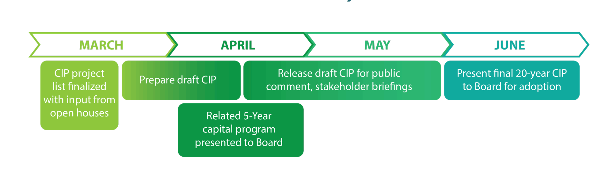
Tell us about you
On average, how often do you use rural County roads such as those on Sauvie Island or in the Columbia Gorge?
(Check one.)On average, how often do you use urban County roads such as those in Troutdale, Fairview and Wood Village?
(Check one.)How do you usually get around?
(Check one.)How would you describe yourself
(Check all that apply.)How did you hear about this online workshop?
(Check all that apply.)What are the best ways to communicate with you?
(Check all that apply.)Contact Information
Optional: Join the list for email updates.
