View the information on this site using the buttons below or click "Get Started" above to move through the content in order.

= Page includes questions or opportunities for comment.
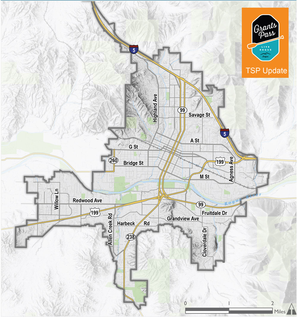
Grants Pass Urban Growth Boundary


Why is this important?
TSPs are required by state law and help decide which new transportation projects are most likely to get funding. The Grants Pass TSP was originally adopted in 1997 and most recently updated in 2008. It is time to revisit the plan and make changes so that it reflects the needs of residents and businesses.
Interchange Area Management Plans
The City of Grants Pass contains two Interstate 5 interchanges (Exit 55 and Exit 58). As a part of this process, two Interchange Area Management Plans (IAMPs) will look at how well these interchanges are meeting current travel needs and describe possible changes. The IAMPs will:
- Examine existing multimodal system facilities, operations and safety.
- Consider the size and type of future development near the interchanges.
- Identify any needed long-range interchange and street system improvements or land use policy actions necessary to protect the function of the interchanges and support the local street network.
Goals
The TSP will be informed by a set of Goals. These goals will provide the project team with direction throughout the project and guide the City after plans are adopted. The project team will use your feedback to refine these draft Goals and to develop performance measures that will be used to evaluate future transportation improvements and projects. A summary of the 1997 TSP Goals are below, along with a suggested new goal: #8 enhancing public health.
- Provide for the safe and efficient accommodation of travel through a variety of transportation modes, including private vehicles, public transportation, bicycles, and walking.
- A well-coordinated plan between the City of Grants Pass, Josephine County and the Oregon Department of Transportation.
- Provide continued funding to invest in the maintenance and operations of the Grants Pass transportation network.
- Provide a transportation network with acceptable levels of traffic congestion, accessibility to jobs and adequate movement of goods to support economic development.
- A transportation plan that helps preserve and enhance the city's physical surroundings and maintains a high quality of life.
- A plan that ensures stable financing sources to fund new transportation improvements and conduct ongoing maintenance and operations.
- A plan with effective strategies to systematically implement the city’s planned transportation improvements.
- Provide a transportation system that enhances the health and safety of Grants Pass' residents.
(Click to enlarge.) The decisions we make today will directly impact how the city can grow in the future. There are currently 143 miles of city streets in the Grants Pass transportation system, as well as over 190 miles of sidewalks and trails. All of this infrastructure requires money to maintain, so we have to choose new investments carefully.
Questions
Is this list of Goals appropriate for guiding the development of the TSP?
(Check one.)Comment Wall: Are there other goals or ideas that need to be reflected in the TSP?
characters remaining.
Read other comments...


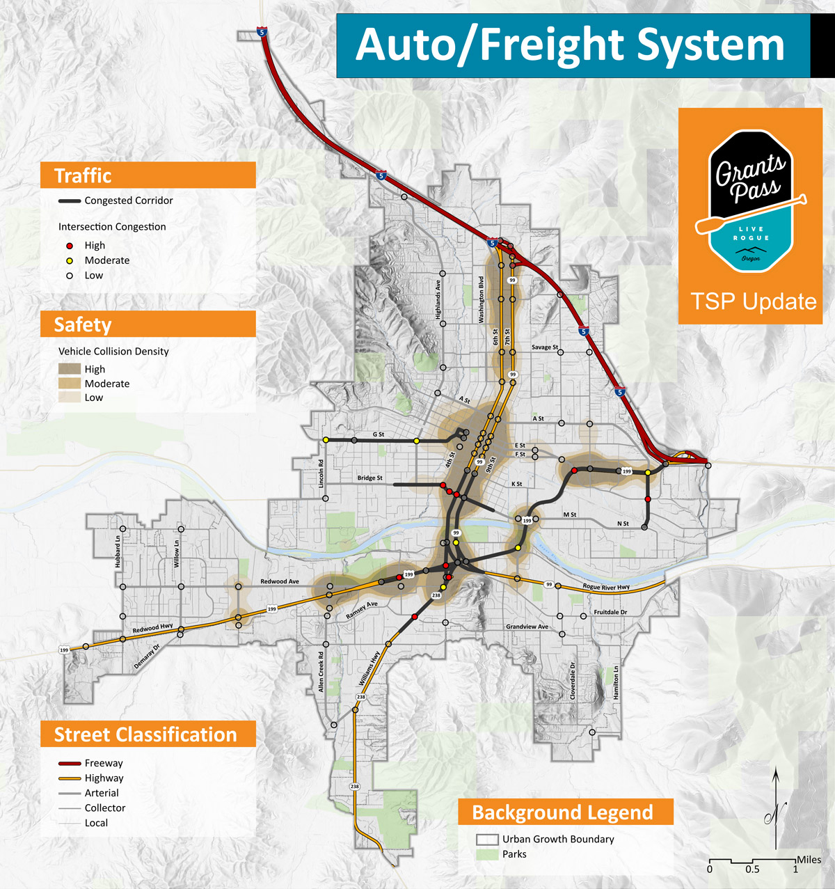

Existing Roadway System
- The three bridges spanning the Rogue River and the US 199/OR 99 junction (the “Y”) are major bottlenecks to traffic within and through Grants Pass.
- There is notable traffic congestion on US 199 during peak hours, especially at Agness Avenue near I-5, E Street, 6th Street/7th Street (OR 99) and Ringuette Street.
- 6th and 7th Streets (OR 99) are congested at Morgan Lane in the I-5 interchange area.
- Other streets and highways experiencing higher levels of traffic congestion include: OR 238 south of US 199, Bridge Street and G Street.
- Historically, there are more vehicle crashes at major intersections along US 199 and OR 99 (6th and 7th Streets).
- Truck traffic passing through Grants Pass primarily uses I-5 and US 199.
- Rail service in and through Grants Pass caters almost exclusively to the wood products industry.
Possible Roadway System Improvements
- Multiple streets and highway routes within and through the city.
- Streets designed to desired travel speeds for public safety.
- Traffic control systems to manage varying vehicle, bicycle and pedestrian traffic demand.
- Well-lit streets for nighttime safety.

Click to enlarge image.
I-5 Interchanges in Grants Pass
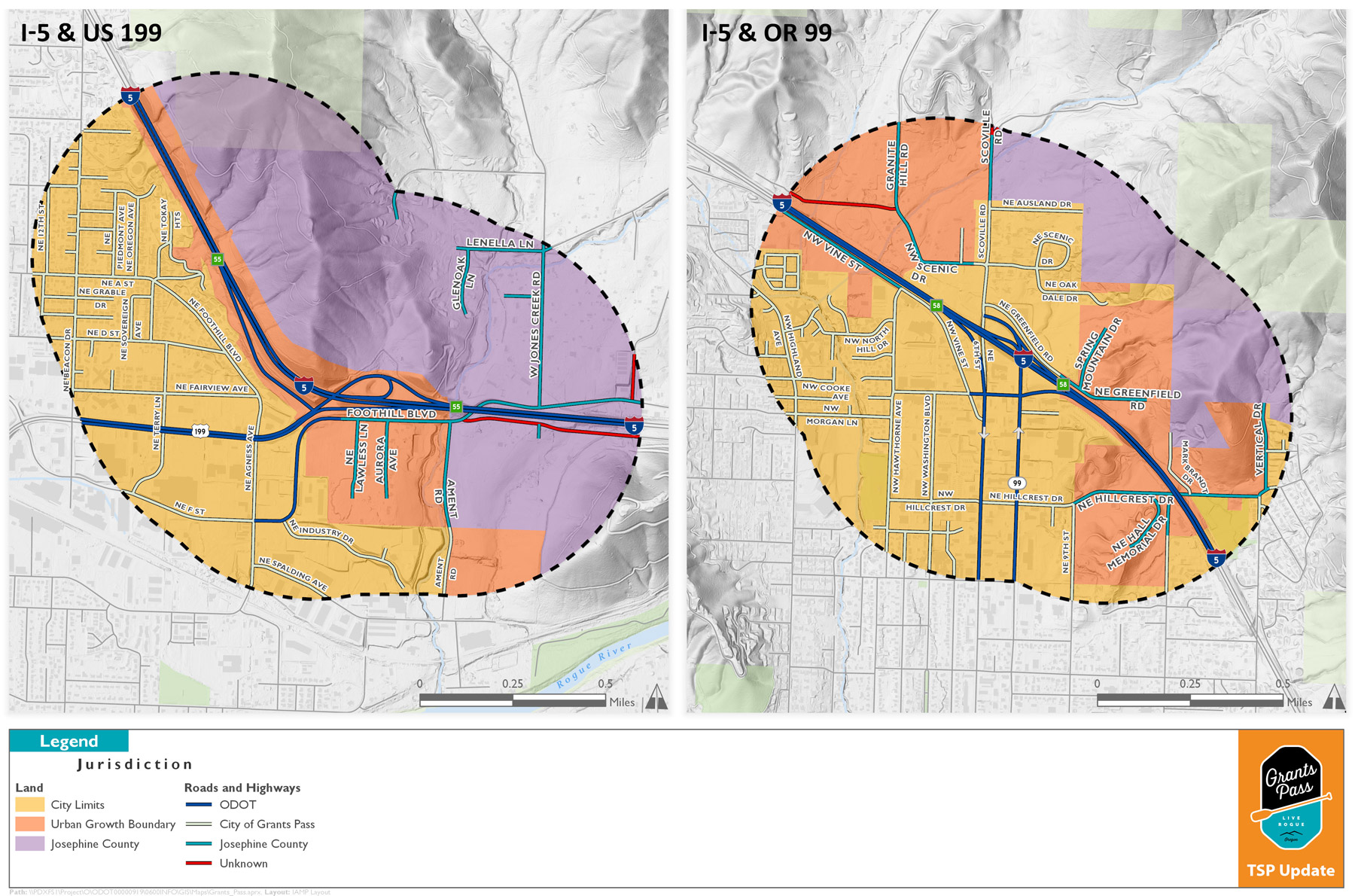
Click to enlarge image.
Questions


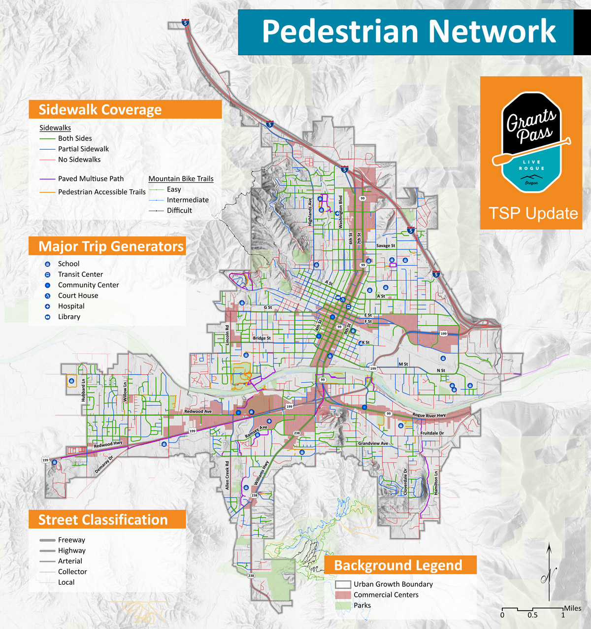

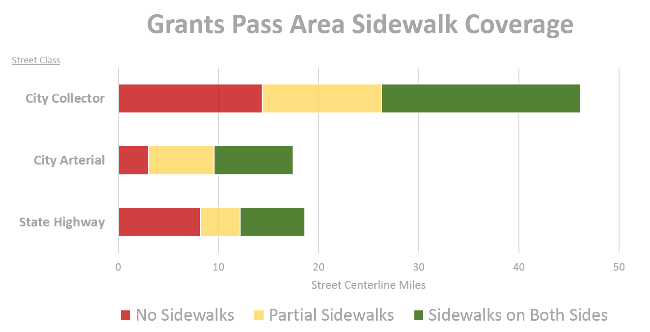
Existing Pedestrian System
- Over 80% of the city’s arterial and collector streets have sidewalks on at least one side.
- The City has recently completed several street improvement projects that added sidewalks and bicycle lanes, including: portions of Park Street, Redwood Avenue, G Street, D Street, Harbeck Road, Drury Lane, Hubbard Land, and Elmer Nelson Bridge.
- There are known gaps in the sidewalk network along some important city arterial and collector streets such as Highland Avenue, Dimmick Street, Beacon Drive, Fruitdale Drive, and Allen Creek Road.
- Long segments of Highway 199 have no sidewalks, though a pedestrian-bicycle path is adjacent to the highway west of Redwood Avenue.
- Only about 2% of Grants Pass residents walk to work.

Possible Pedestrian System Improvements
- Barrier free sidewalks along streets with fewer travel lanes, lower traffic volumes, and slower vehicle speeds.
- Street and sidewalks separated by on-street parking and/or landscaping.
- More direct routes to schools, parks, community centers and other walking attractions.
- Wider sidewalks along commercial streets within the city center with shade trees, benches, and other amenities.
- Well-lit sidewalks and street crossings for nighttime safety.
- Separated pedestrian-bicycle pathways similar to the path across the Rogue River linking Reinhart Volunteer Park and Tussing Park.

Click to enlarge image.

Click to enlarge image.
Questions


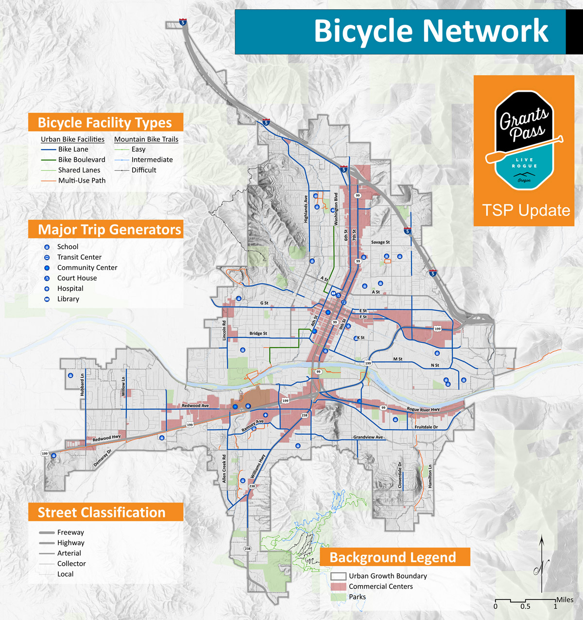

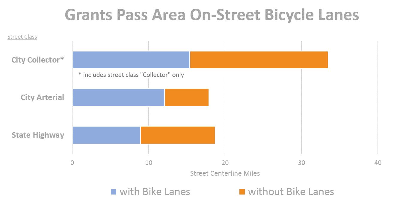
Existing Bicycle System
- Over 70% of the city’s arterial and collector streets have on-street bicycle lanes.
- The City has recently completed several street signing and pavement treatments to formalize on-street bike lanes on routes and Park Street and 4th Street, or designate “Bicycle Boulevards” on routes like Bridge Street and 3rd Street.
- Gaps in the bike lane network along key arterial and collector streets (e.g. Highland Avenue, 6th Street (through the city center), Beacon Drive, A Street, Savage Street, J Street, Allan Creek Road, Harbeck Road and Cloverlawn Drive.
- Only 1.3% of Grants Pass residents bicycle to work, slightly lower than their nearest-neighbors in Medford and Roseburg.
- Pedestrian-bicycle path across Rogue River linking Reinhart Volunteer Park and Tussing Park is very popular as are other short pathway segments throughout the city. However, the pathway network is disconnected.
Possible Bicycling System Improvements
- Designated bicycle lanes along streets with fewer travel lanes, lower traffic volumes, and slower vehicle speeds.
- Separated pedestrian-bicycle pathways.
- Bicycle parking racks and other end of trip facilities.

Click to enlarge image.
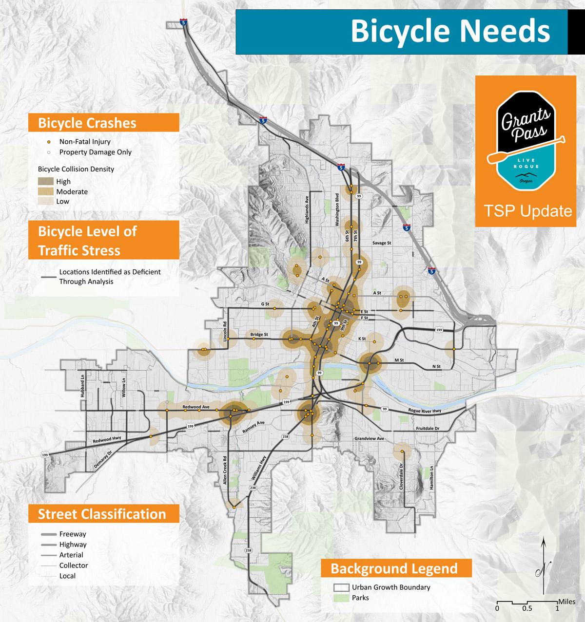
Click to enlarge image.
Questions


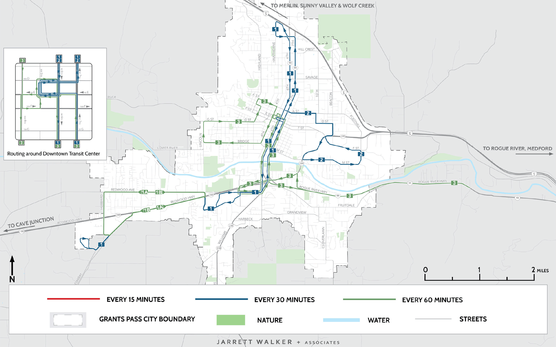

Existing Service
- Complete New Downtown Transit Center
- Four Local Bus Routes – 10, 20, 35 and 40
- On-Demand Paratransit Service
- Long-Distance Commuter Bus Routes: Cave Junction (50) Merlin, Hugo, Sunny Valley and Wolf Creek (80) Medford via Rogue River and Gold Hill
Near-Term Service Improvements
Step 1: Restructure and Re-number Current Bus Routes to Improve Coverage
- Route #1: 30 minute service connecting North End, Downtown, Three Rivers Hospital and Rogue Community College
- Route #2: 30 minute service connecting Downtown and east commercial, industrial and residential areas
- Route #3: Combines hourly service west of Downtown to Two-Way service on Rogue River Highway
Long-Term Service Improvements
Step 2: Provide Saturday Service
Step 3: 30-Minute Service on Route 3
Step 4: Evening Service – all three local bus routes
Step 5: New Service to Murphy and Williams
Step 6: New Service along Highland Avenue and Williams Highway
Near-Term Transit System

Click to enlarge image.
Future Transit System
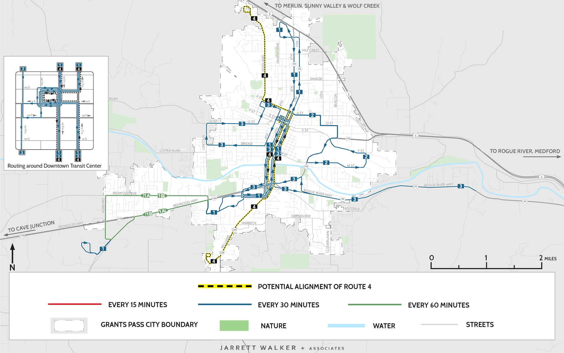
Click to enlarge image.
Questions
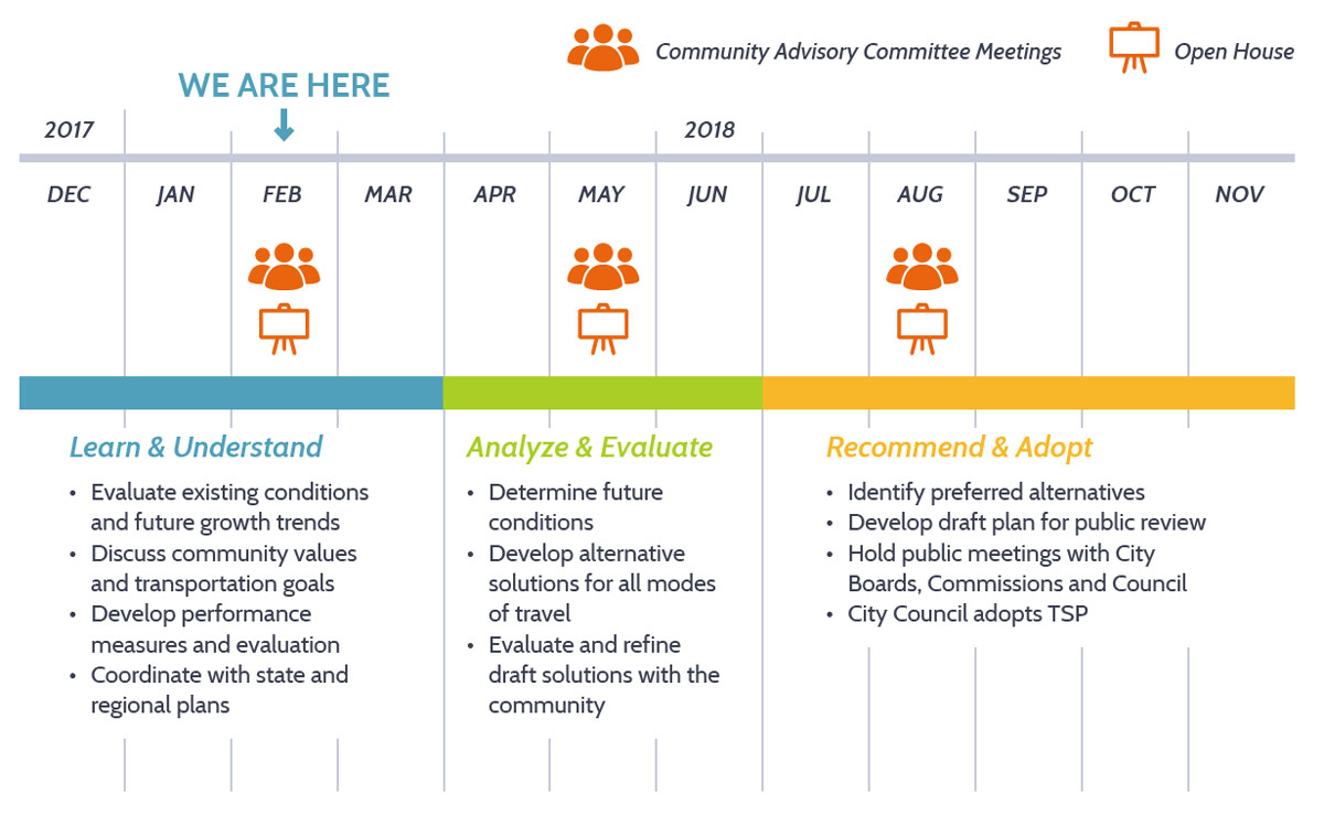
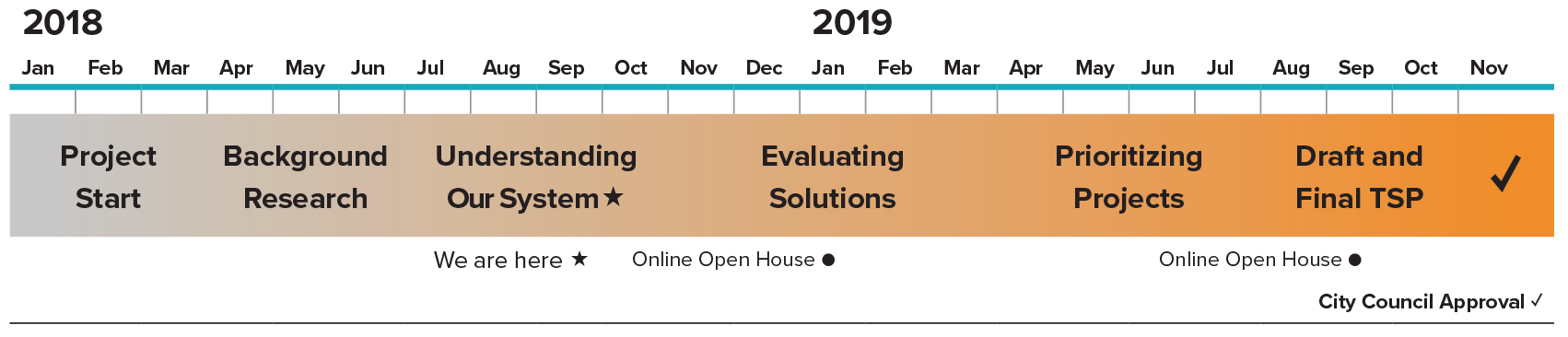
Project Schedule

Stay involved
- Learn more at GrantsPassOregon.gov/1201
- Sign up for email updates below.
Timeline
Final questions
Before you leave, be sure to submit any comments you've provided.
