
Project Information
- November Newsletter (pdf, 6.7 MB)
- Technical Memos (LINK)
Open House Stations

= Page includes questions or opportunities for comment.
Schedule

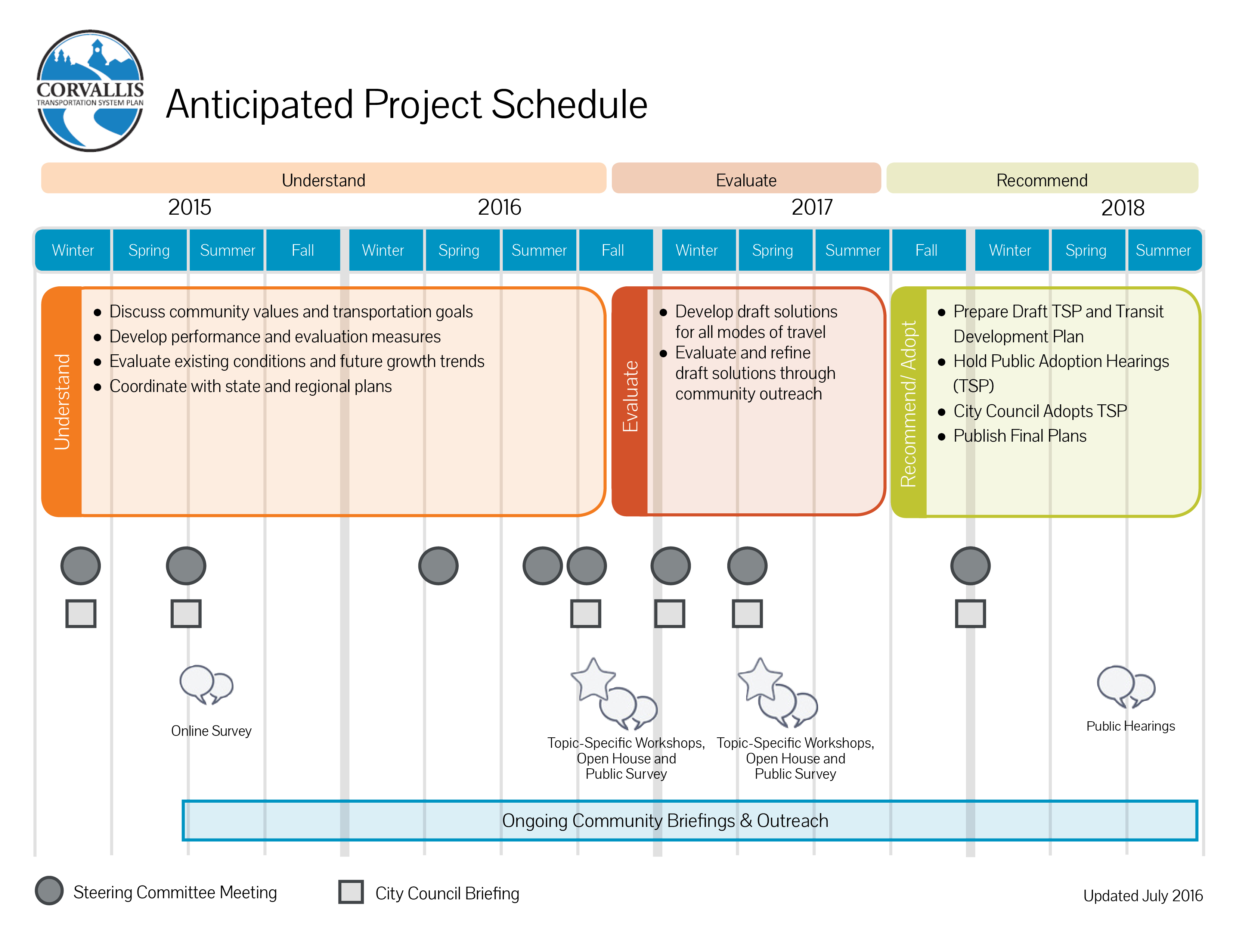

Project Update
The project has achieved many milestones since kick-off. A project Steering Committee was formed to provide a community perspective to the process of developing the Transportation System Plan update and Transit Development Plan. Their meetings are open to the public. Last year, a city-wide survey gathered information from people living and working in Corvallis about the TSP goals. The team used that input to refine the draft goals and objectives. The project goals include:
- Providing an efficient transportation system that supports economic vitality by facilitating the local and regional movement of people and goods.
- Providing a transportation system that enhances the health and safety of residents.
- Providing a diversified and accessible transportation system that ensures mobility for all members of the community and provides viable alternatives to automobile travel.
- Providing a sustainable transportation system through responsible stewardship of financial and environmental resources.
Most recently, a series of memos were prepared identifying transportation challenges and opportunities in Corvallis. You can review summaries of these findings on the following pages.
A draft TSP document is expected to be complete by fall 2017 with an adopted final draft by summer 2018.
Provide Your Input
On the following pages you can learn about the current and future needs for driving, biking, walking and taking transit in Corvallis, then provide your ideas for solutions that address these needs. This is an important time for you to weigh in on the project. Your input will be used to inform the project team as they develop solutions to meet our transportation and transit needs over the next 20 years.
Existing Driving Conditions and Key Issues (2014)
- Nearly two thirds of the workers in Corvallis live in another city, encouraging travel by motor vehicle.
- Motor vehicle volumes on the roadways in Corvallis most commonly peak during weekday evenings between 4:45 p.m. and 5:45 p.m.
- Within Corvallis, most truck traffic is concentrated on the state highways (US 20, OR 34, and OR 99W), which are classified as state and federal freight/truck routes.
- The one-lane Van Buren Bridge is a key congestion bottleneck that cannot accommodate large trucks and emergency service vehicles due to a weight restriction and substandard vertical clearance.
- Corvallis experiences around 530 crashes a year, though the severity of most crashes is generally low, with 83 percent involving only property damage or minor injuries. Crashes involving pedestrians and people on bikes generally result in higher severity injuries.
- Most crashes result from mistakes, so solutions involving education and enforcement may be most effective.
- A common complaint is that traffic diverts through neighborhood streets to avoid congested corridors.
Future Driving Conditions and Key Issues (year 2040)
- Vehicle-miles Traveled (VMT) per capita is projected to increase by 19% if no further investments in the transportation system are made.
- Congestion on the Van Buren Bridge and OR 34 to the east will increase significantly, likely leading to diversion of traffic to US 20 and OR 99W (north).
- Over-capacity conditions on US 20-OR 34 between Philomath and Corvallis has the potential to increase traffic on city streets, with re-routing onto parallel roadways such as SW West Hills Road and SW Western Boulevard.
- By 2040, the number of congested intersections failing to meet mobility standards is expected to double. The most congested areas will likely be along state highway corridors.
- The travel times for most freight/truck routes are expected to increase by up to 30 percent except eastbound OR 34 where travel times are expected to double, both from downtown (via Van Buren Avenue) and via the OR 34 Bypass.
Use the map below to provide comments
To place a comment, click the " + Comment" button which will reveal a crosshairs on the map. Click and drag the map with your mouse to center the cross-hairs on a location, or use the search box to find a specific address. You can use the zoom buttons (+/-) to view more or less map detail. Click "Place Comment" to place a marker on the map. To read and respond to other comments, click the icons on the map. Click "Reset" to re-center the map.
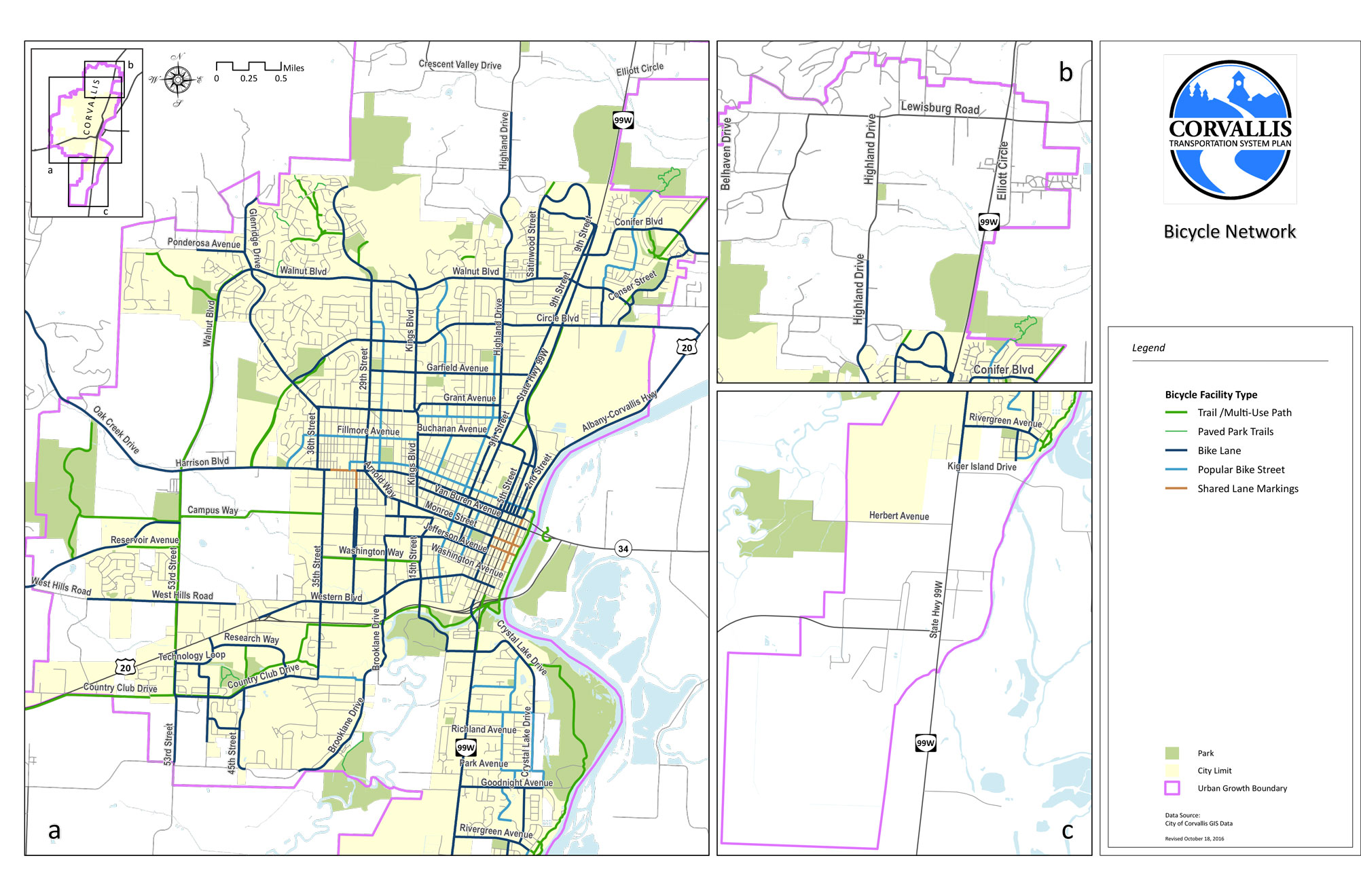
Map Legend
 | High Crash Location |  | Congested Corridor |
 | Freight Issue |  | Higher Collision Density |
 | Public Comment |  | |
 | Additional Information |  | Lower Collision Density |
Comments
Qualities of Good Bicycle Facilities
- Presence of bike lanes
- Fewer travel lanes
- Low speed limits
Existing Bicycle Conditions
- 12% of Corvallis residents bike to work (2nd highest bike mode share in country) 2
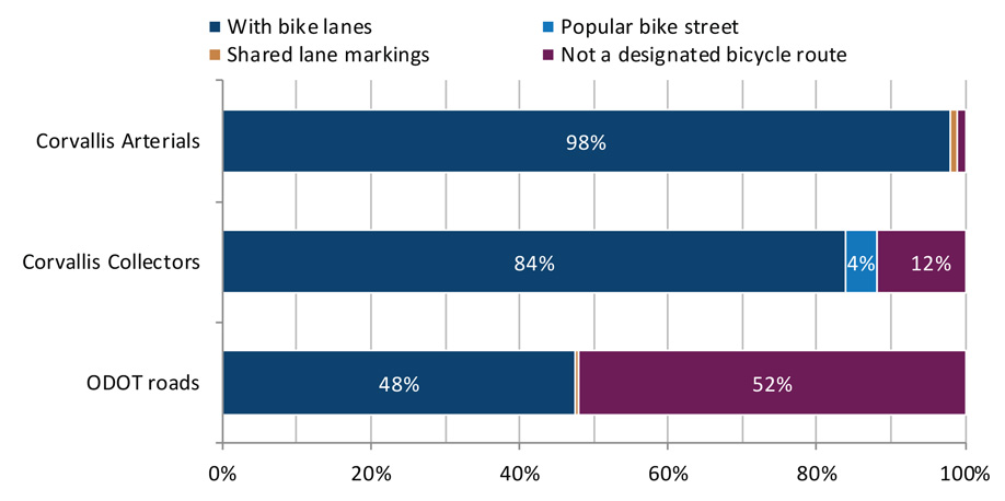
- More than 80% of Corvallis arterials and collectors have bike lanes
- Half of ODOT roads have bike lanes
- High bicycle stress on larger roadways
Bicycle Concerns
- Safety at intersections and vehicle right turns
- Crossing wide streets with heavy traffic volumes present barriers along low stress bike streets, such as: Tyler Avenue at 9th Street; Jackson Ave at 3rd/4th Streets; Adams Ave at 4th Street
- Vehicle speeds and traffic density are a concern
- Bike lanes need better maintenance and design
- Heavy conflicts between modes of travel surrounding OSU
2 For communities of 50,000 or more. US Census ACS 2010-2015 5-Year Estimates
Use the map below to provide comments
To place a comment, click the " + Comment" button which will reveal a crosshairs on the map. Click and drag the map with your mouse to center the cross-hairs on a location, or use the search box to find a specific address. You can use the zoom buttons (+/-) to view more or less map detail. Click "Place Comment" to place a marker on the map. To read and respond to other comments, click the icons on the map. Click "Reset" to re-center the map.
Map Legend
 | Intersection With Extreme Bicycle Stress | | Higher Collision Density |
| Deficient Roadway Segment* | | |
 | Public Comment | | Lower Collision Density |
*Deficient segments were identified if they met one or more of the following criteria: High or extreme bicycle stress near important destinations; Extreme stress in urbanized areas; Moderate, high or extreme stress near transit with 30 or more trips per day; High or extreme stress near transit stops; Moderate, high or extreme stress along a Safe Routes to School network; Substandard ODOT facility.
Comments
Qualities of Good Pedestrian Facilities
- Low traffic volumes
- Low speed limits
- Fewer travel lanes
- On-street parking or landscaped buffer between roadway and sidewalk
Existing Pedestrian Conditions
- 12% of Corvallis residents walk to work (17th highest walk mode share in the country)1
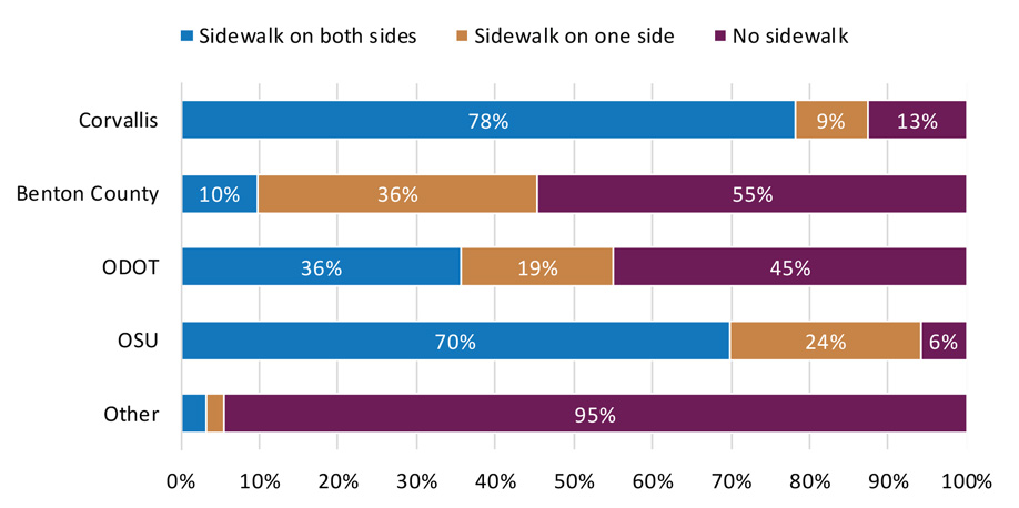
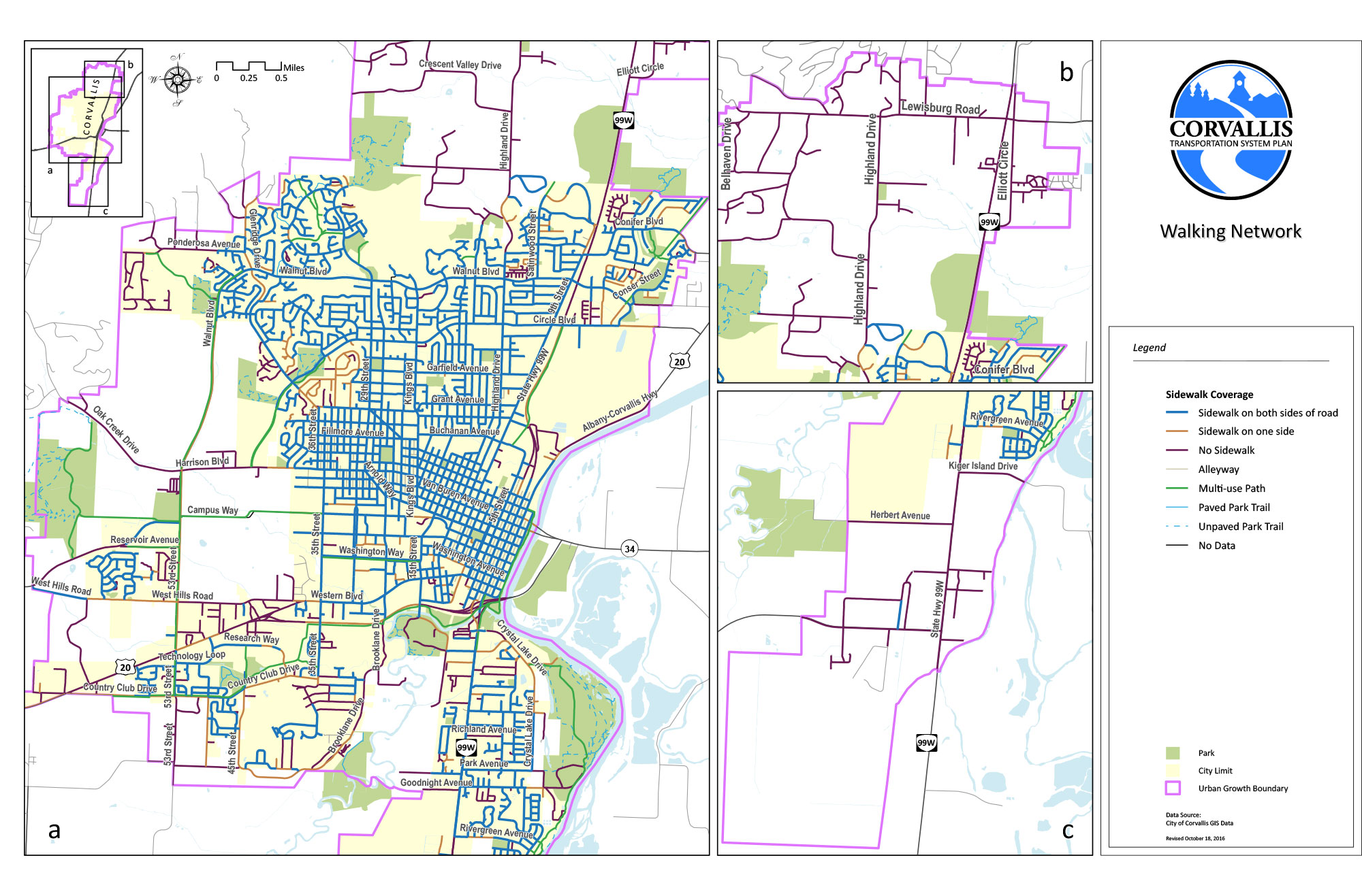
- 78% of roads owned by the City of Corvallis and 36% of roads owned by ODOT have sidewalks on both sides (71% overall)
- High pedestrian quality exists on most roads in Corvallis; however larger and busier streets tend to have lower quality
Pedestrian Concerns
- Downtown and commercial areas do not feel pedestrian friendly
- Heavy conflicts between modes of travel on Monroe, Harrison, and other streets around OSU
- Vegetation encroaching into sidewalks/multi-use paths
- Gaps in sidewalk system
- Establishing Safe Routes to Schools
- Sidewalks on some of the city’s bridges are too narrow
1 For communities of 50,000 or more. US Census ACS 2010-2014 5-Year Estimates
Use the map below to provide comments
To place a comment, click the " + Comment" button which will reveal a crosshairs on the map. Click and drag the map with your mouse to center the cross-hairs on a location, or use the search box to find a specific address. You can use the zoom buttons (+/-) to view more or less map detail. Click "Place Comment" to place a marker on the map. To read and respond to other comments, click the icons on the map. Click "Reset" to re-center the map.
Map Legend
 | Intersection With Low Pedestrian Quality | | Higher Collision Density |
| Deficient Roadway Segment* | | |
 | Public Comment | | Lower Collision Density |
*Deficient segments were identified if they met one or more of the following criteria: Pedestrian quality less than high near important destinations; Low quality in urbanized areas; Pedestrian quality less than high near transit with 30 or more trips per day; Medium or lower quality near transit stops; Pedestrian quality less than high along a Safe Routes to School network; Substandard ODOT facility.
Comments
Existing Transit Conditions
- Route design aligned with community characteristics
- 2 of the 8 all-day routes have 30‑minute frequencies
- Ridership increased following implementation of fare free operations (February 2011) and is now stable
- High ridership relative to level of investment in transit
- On-time performance not meeting expectations
- Transit dependent populations are concentrated in SE Corvallis and areas of North Corvallis
- Kings Blvd., 9th St. and SE Corvallis are highest boarding areas
Potential Future Transit Service Needs
- Expected population growth in SE and western Corvallis
- Expected employment growth in NE and SW Corvallis
Outreach - Community Feedback on Barriers to Using Transit
- On-time performance issues
- Lack of weekend service
- Indirect routes – out-of-direction travel
- Does not go where potential rider wants
- Trip planning difficulties
- No stop near home
Outreach - Rider Feedback on Desired Improvements
- Better on-time performance
- Sunday service
- More frequent service
- Later service at night
- More Saturday service
- Service earlier in the morning
- Easier transfers
Use the map below to provide comments
To place a comment, click the " + Comment" button which will reveal a crosshairs on the map. Click and drag the map with your mouse to center the cross-hairs on a location, or use the search box to find a specific address. You can use the zoom buttons (+/-) to view more or less map detail. Click "Place Comment" to place a marker on the map. To read and respond to other comments, click the icons on the map. Click "Reset" to re-center the map.
Map Legend
| Roadway With Forecasted Congestion |
 | Public Comment |
Comments
Comment
- Submit your comments using the form below.
- Visit www.CorvallisTSP.org to provide comments anytime.
- Email: info@CorvallisTSP.org.
- Contact the Project Manager: Adam Steele, Corvallis Public Works Project Manager at (541) 766-6916 or adam.steele@corvallisoregon.gov
Stay Informed
- Sign up for the mailing list below.
- Attend our next Open House in the spring.
Tell us about yourself
Mailing list
Provide your contact information if you would like to be added to the project mailing list. (Optional.)Demographic Questions (Optional)
Before you leave, be sure to submit any comments you've provided. (The option to review and submit answers will appear after you answer at least one question.)
