
Stations
In this open house there are a series of stations where you can learn about the project and provide input. Go directly to a station using the buttons below, or at the top of the screen to move through the stations in order.

= Page includes questions or opportunities for comment.


The main objectives of the ATP are to:
- Enhance safe opportunities for walking, biking, and taking transit to the destinations they need to reach: schools, employment, transit, and other community destinations.
- Ensure that all neighborhoods in Beaverton have options for walking, biking, and transit.
- Reduce climate-changing emissions.
- Create a network of low-stress neighborhood routes to serve all ages and abilities of bicyclists and pedestrians.
- Improve safety for all modes.
- Set up Beaverton transportation projects to be competitive for grants and regional funding opportunities.
In the following stations, we'll describe some of the feedback we've heard so far and give you the opportunity to provide feedback on the types of bike and pedestrian facilities being proposed in the ATP.
What we learned from bicyclists
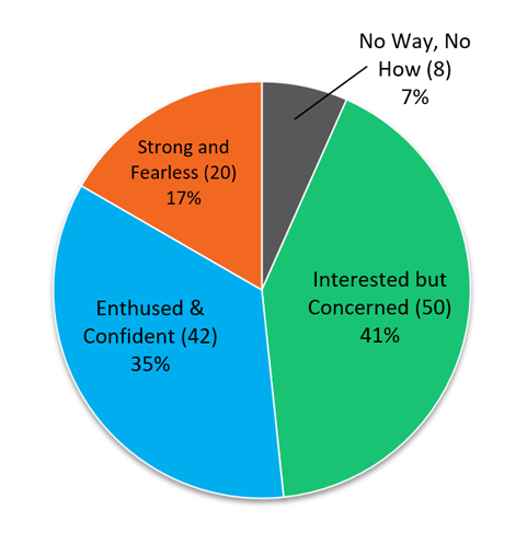
"What type of bicyclist are you?"
At the first virtual open house, participants were asked to define what type of bicyclist they are based on the “Four Types of Bicyclists” – Strong and Fearless, Enthused and Confident, Interested but Concerned, No Way No How.
A total of 50 participants identified as "Interested, but Concerned"bicyclists. This group in particular was reviewed, since they represent the "target rider" for bicycle facility design in Beaverton. The graph below illustrates this group’s responses to the survey questions that followed, regarding their comfort level on the various bicycle facilities in Beaverton.
"Would you be comfortable bicycling here?" (Interested but Concerned Respondents only)
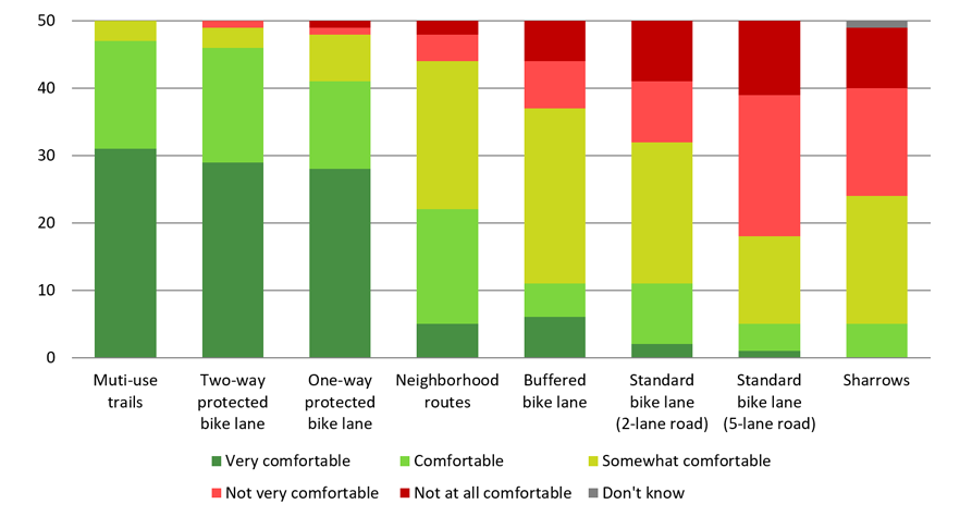
The feedback provided to us by those who identified as "Interested but Concerned" bicyclists conveys a clear desire to provide protected bicycle facilities in the form of multi-use trails and protected bicycle lanes. Providing bicycle infrastructure that accommodates this group of "Interested but Concerned" bicyclists has the greatest potential of increasing bicycling in Beaverton.
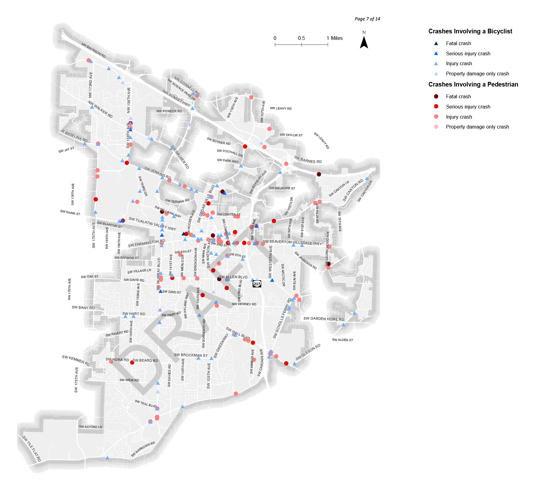
What we learned from pedestrians
In the first virtual open house, participants were also asked how they felt about different pedestrian facilities in Beaverton. We received feedback about treatments that make people feel comfortable and what makes them uncomfortable. Most comments received were related to needs for improved crossings at existing locations by providing safety enhancements in the form of paint, American’s with Disabilities Act (ADA) compliant facilities, and traffic calming features. Comments were also received relevant to improving routes by providing sidewalk facilities in missing network gaps and enhancing existing facilities.
Each comment is being considered to help the project team understand where there is a need or desire for an improvement, and will ultimately help inform the policies and projects included in the Active Transportation Plan.
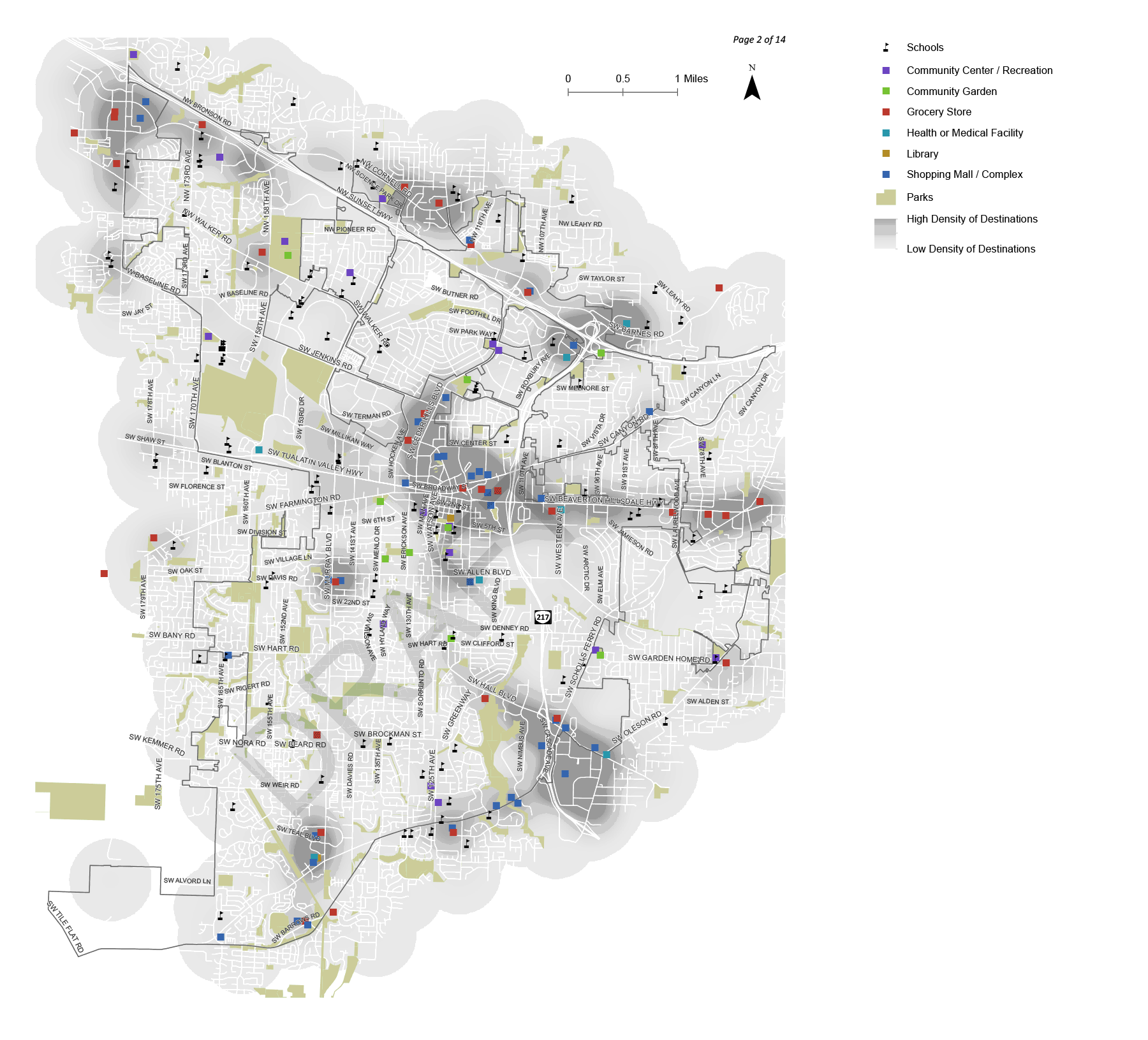
Proposed pedestrian functional classifications

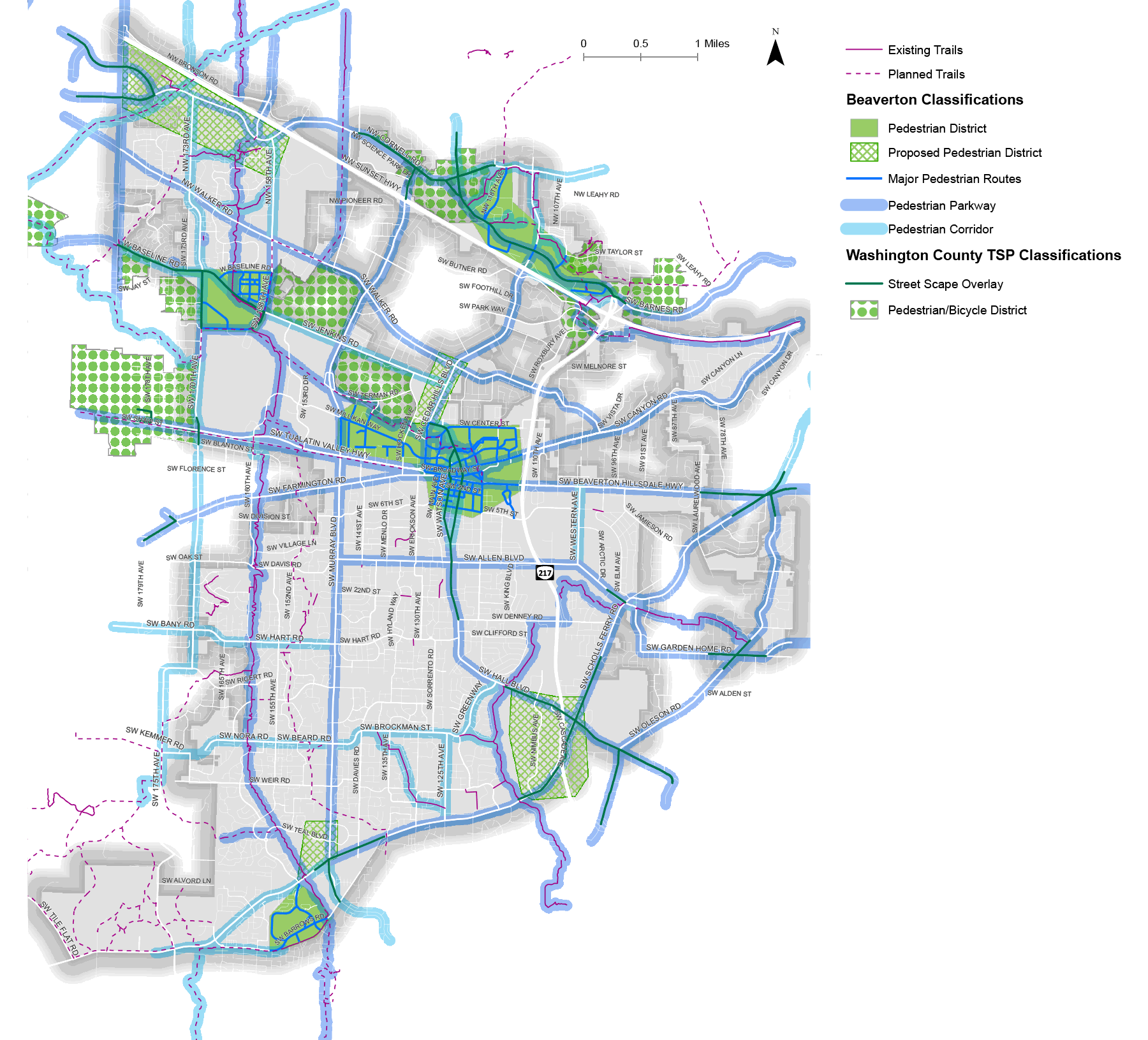
Defining Functional Classifications for Pedestrians
Pedestrian Parkways
Typically proposed for major streets with transit service (arterials and collectors) or along regional trails. Provide direct regional connections over longer distances and have enhanced crossings at transit stops.
Pedestrian Corridors
Proposed on minor collectors and arterials with transit service or along regional and local trails. Provide connections between pedestrian parkways and have enhanced crossings at transit stops.
Local Streets
Local streets provide connections between residential areas and local destinations, and between pedestrian parkways and corridors. All local streets serve as designated routes for pedestrians.
Pedestrian Districts
Areas that currently have or are planned to have a mix of land use types and densities that support high level of pedestrian activity. Highly connected networks and frequent, safe and accessible enhanced crossings at arterials, collectors and other types of barriers. Washington County’s designated Pedestrian Districts in unincorporated areas are also identified to show all areas that are anticipated to be designed as pedestrian orientated areas.
Washington County Designations
Washington County Streetscape Overlay
A Washington County requirement for enhanced pedestrian treatments, as defined by the Washington County Pedestrian Enhancements Guidelines or other applicable County standards. This is shown to identify where sidewalks may be required to be wider than standard along County roadways within the City of Beaverton.
Washington County Pedestrian and Bicycle Districts
Washington County Pedestrian and Bicycle Districts are classified as Regional Centers, Town Centers and Station Communities in Metro’s 2040 Growth Concept. Pedestrian and Bicycle Districts have high pedestrian and bicyclists use observed or intended and use of enhanced street design features to help foster the envisioned land use, economic and transportation mode share targets. Washington County’s Pedestrian/Bicycle Districts are located in unincorporated areas and are shown to identify all areas anticipated to be designed as pedestrian oriented.
Questions
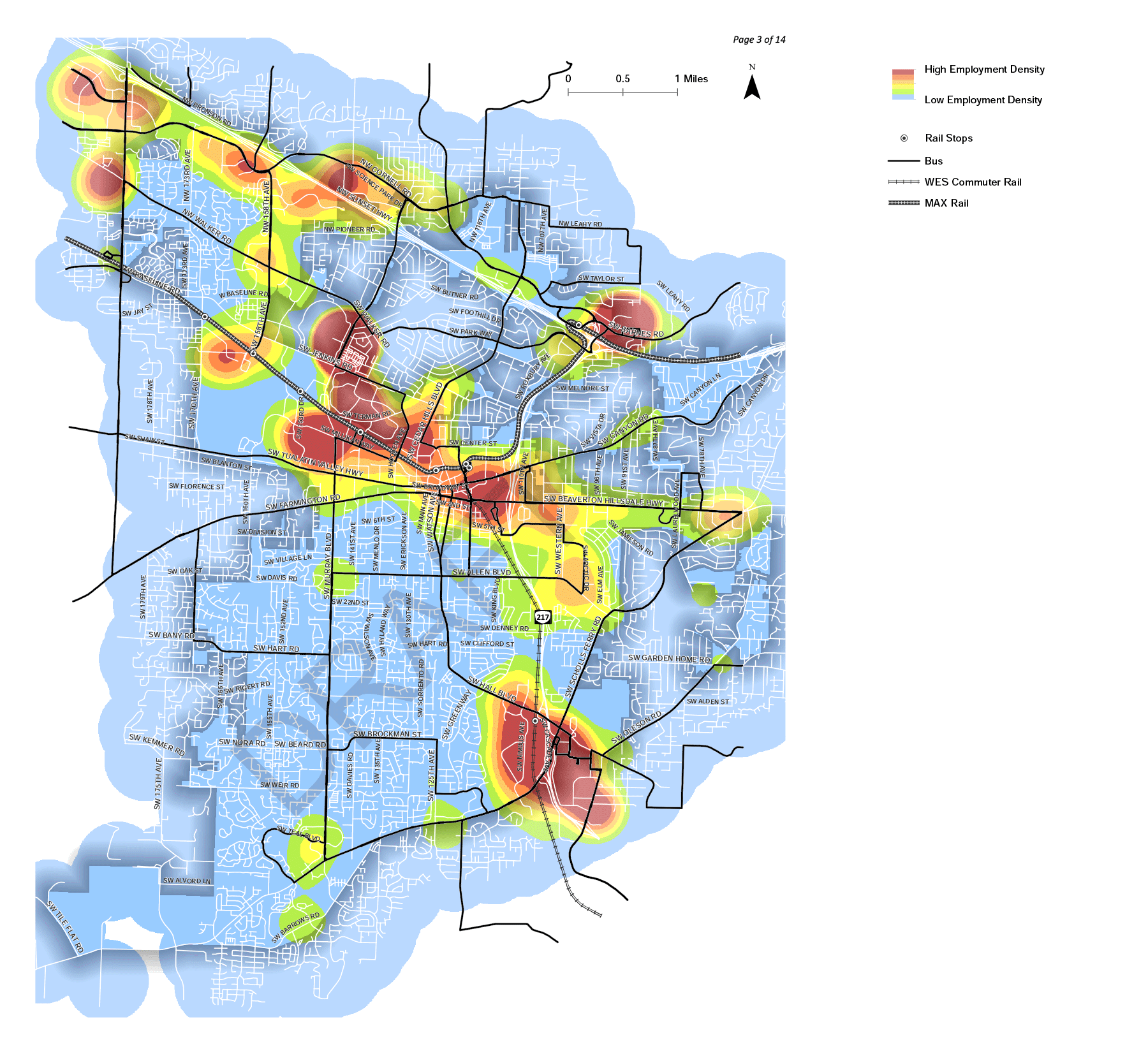
Proposed bicycle functional classification map

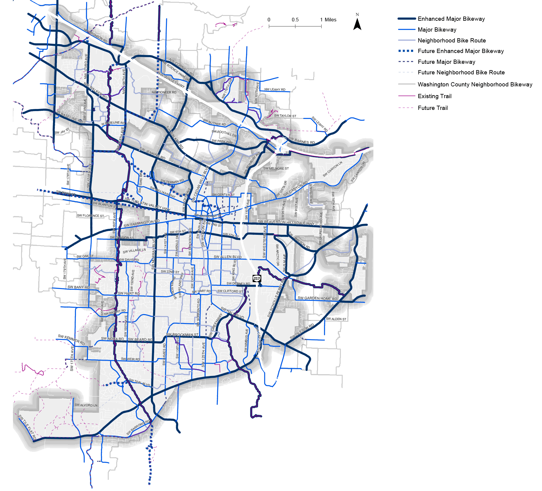
Defining Functional Classifications for Bicyclists
Enhanced Major Bikeways
Proposed along major arterials where vehicle volumes and speeds are high. Provide an exclusive space for bicyclists along or within a roadway that is physically separated from motor vehicles by vertical or horizontal elements.
Major Bikeways
Proposed on collectors and occasional arterials where vehicle volumes and speeds are high but less than a major arterial. Designated space for bicycle travel separated from motor vehicles with paint or temporary vertical elements such as flex-post or bollards. The separation between bicycles and motor vehicles for major bikeways largely depends on the context of the corridor.
Neighborhood Bikeways
Proposed on residential streets where vehicle volumes and speeds are low. Provide sharrows, designated to inform motorist to expect bicyclists to be in the middle of a travel lane while also serving as a wayfinding resource for bicyclists in neighborhood bikeway networks.
Questions
Proposed bicycle facilities

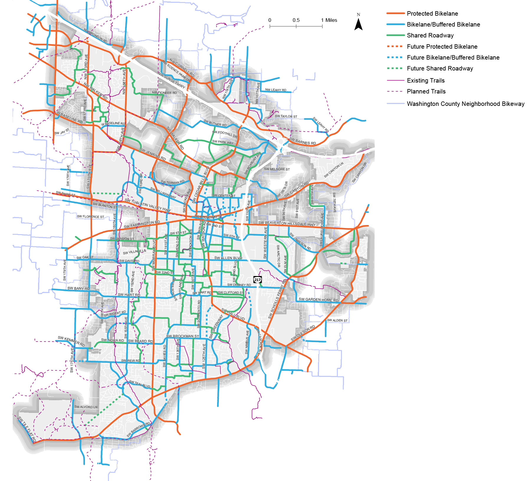
Bicycle facility types
Protected Bike LanesTypically located on major arterials with high vehicular volumes, a protected bike lane is an exclusive space for bicyclists along or within a roadway that is physically separated from motor vehicles by vertical and horizontal elements. They may be one-way or two-way facilities as shown here. | 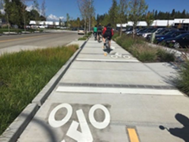 | 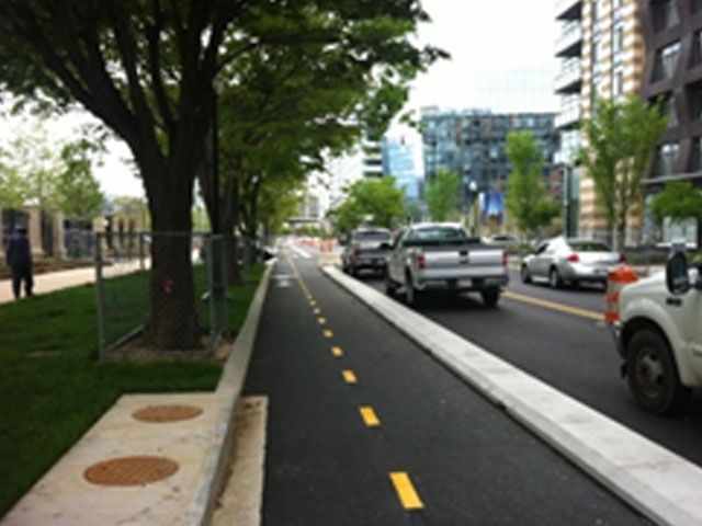 |
Buffered Bike LaneProvides physical separation in the form of vertical flexible posts or paint. Buffered bike lanes are typically suggested for collector roadways with medium to high vehicular speeds and volumes. | 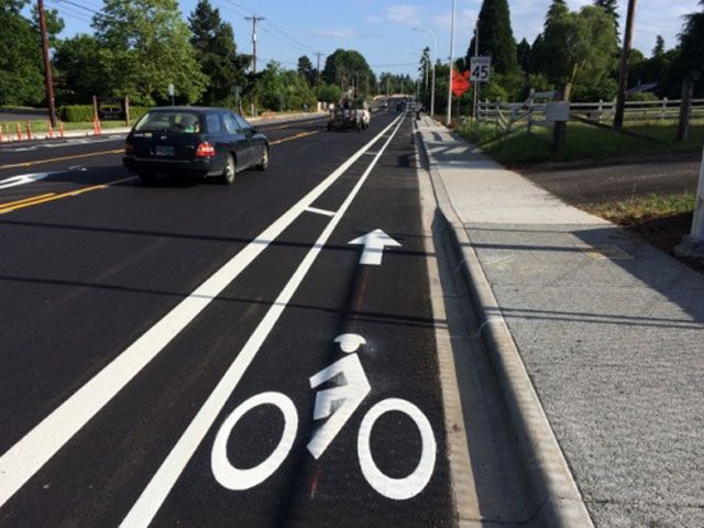 | 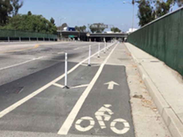 |
Bike LaneDesignated exclusively for bicycle travel, bike lanes are separated from vehicle travel with striping and include pavement stencils. They may include additional enhancements such as green paint. | 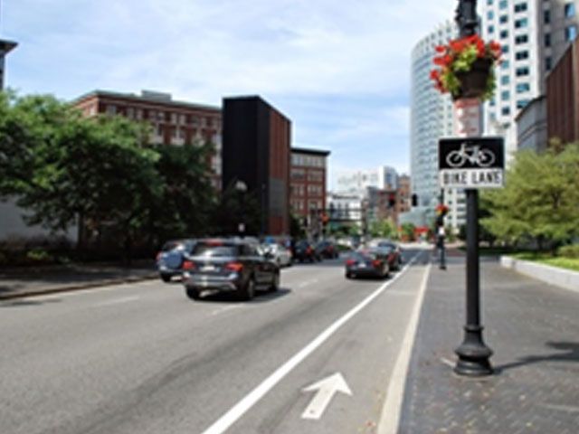 | 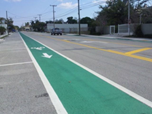 |
Mixed Traffic or Shared Lane Marking (Sharrow)Typically located on neighborhood streets with low vehicular volumes and speeds, “sharrows” are designated to inform motorists to expect cyclists to be in the travel lane. Shared lane markings also provide wayfinding for bicyclists on and neighborhood bike routes. | 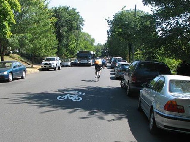 | 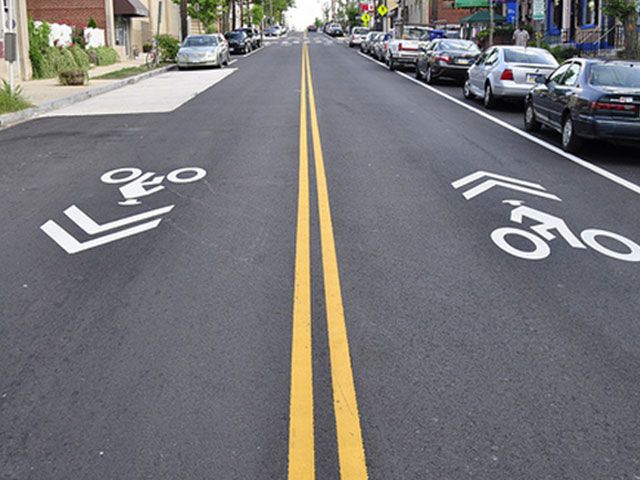 |
Facility map (give feedback)
Click map elements to read about segment proposals and offer your feedback.Click "Reset" to re-center the map.
Questions

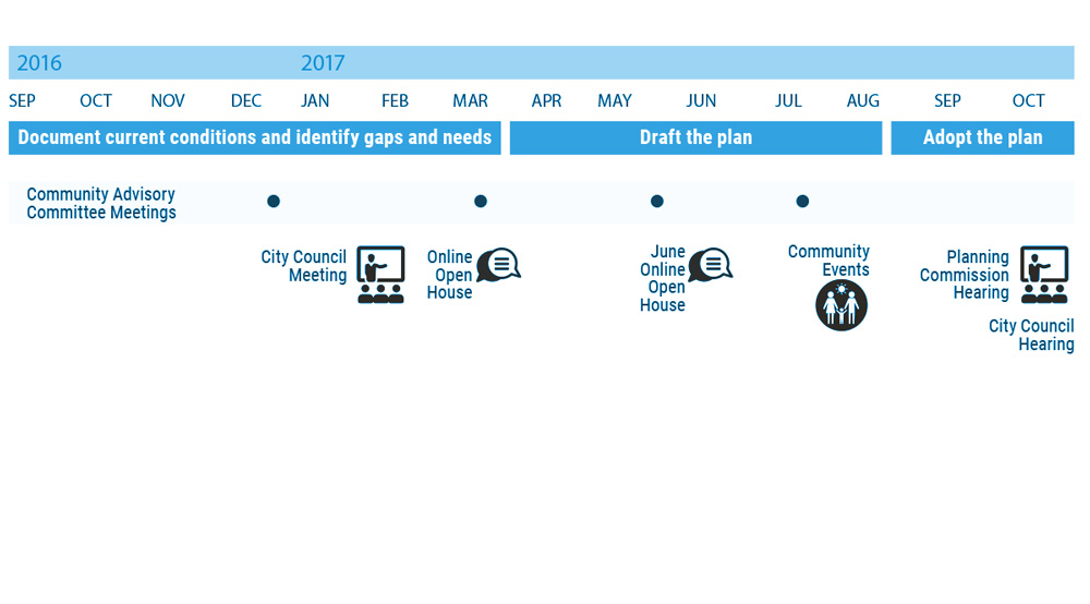
Project timeline

For More Information
- Visit the project website: BeavertonOregon.gov/ActiveTransportationPlan
- Contact: Todd Juhasz, Transportation Division Manager, (503) 526-2424
- Sign up for project updates below...
Final Questions
Mailing list (Optional)
Provide the following optional contact information if you would like to be added to the project mailing list.
Demographic Information (Optional)
This information can help us evaluate the effectiveness of our public outreach activities and tell us if we are reaching a representative cross-section of our community. The identity of individuals is kept confidential. The results are reported as totals only, and used solely to help improve future community engagement. Providing this information is voluntary and optional.
